A Caribbean map can show a sea, an island region or a collection of countries and territories. Those are not identical outlines. Separating the mainland shores, island groups and ocean passages makes the physical geography much easier to read.
The Caribbean Sea is a tropical Atlantic sea bordered by Central America, northern South America and the Antilles. Its mainland coasts extend from Mexico to Venezuela, while its islands include sovereign countries and territories. The wider Caribbean region also reaches into the Gulf of Mexico and neighboring Atlantic waters.
How to use this article: Find the mainland coasts, distinguish the island groups, or follow the connecting passages.
1. Where the Caribbean Sea lies
The sea is smaller than the wider region
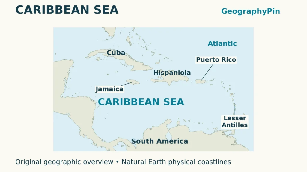
The Caribbean Sea lies in the tropical western Atlantic, between the mainland Americas and the Antilles. Central America forms its western side, northern South America its southern side, and islands frame the northern and eastern approaches. On a world ocean map, it belongs to the Atlantic system rather than constituting a separate ocean.
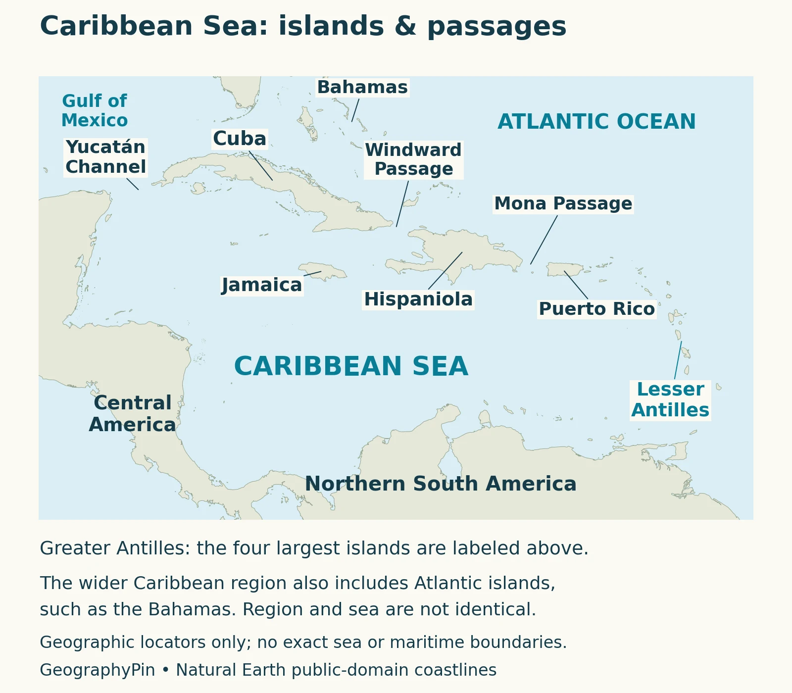
The wider Caribbean is a different geographic frame. UNEP’s Cartagena Convention covers the Caribbean Sea, the Gulf of Mexico and adjacent Atlantic waters. Its regional membership therefore cannot simply be copied into a list of countries bordering this sea. A map designed for environmental cooperation can legitimately cover more territory than a physical map of the Caribbean basin.
The Bahamas and Bermuda illustrate the distinction: both are associated with the wider Caribbean, but lie in the Atlantic rather than inside the Caribbean Sea proper. Barbados needs more care. Hydrographic conventions can include it within the sea’s eastern limit, so a simple line through the main island arc is not a universal boundary.
2. Mainland coasts and island jurisdictions
Follow the mainland from Mexico to Venezuela
The mainland shoreline runs from Mexico’s Yucatán Peninsula south through Central America, then east along northern South America. The table separates these coastal states from the islands, which have a mixture of sovereign countries and territories. It is a mainland orientation list, not a total for every Caribbean jurisdiction.
| Coastal stretch | Countries |
|---|---|
| Yucatán and northern Central America | Mexico, Belize, Guatemala and Honduras |
| Southern Central America | Nicaragua, Costa Rica and Panama |
| Northern South America | Colombia and Venezuela |
El Salvador is a useful contrast within Central America: its coast faces the Pacific, not the Caribbean. Membership in a continental region does not automatically provide a shoreline on both sides. Likewise, a country’s participation in Caribbean regional organizations does not by itself establish a coast on the Caribbean Sea.
Island names and political names also differ. Hispaniola is one island shared by Haiti and the Dominican Republic. Puerto Rico is an island and a U.S. territory, not a separate sovereign state. The U.S. and British Virgin Islands are distinct jurisdictions despite sharing a geographic group name. For the political inventory, use the separate Caribbean countries and territories map.
3. Greater and Lesser Antilles
Two group names, several geological stories
Cuba, Hispaniola, Jamaica and Puerto Rico are the main large-island reference points in the Greater Antilles. Smaller islands, including the Caymans, also appear in broader groupings. These names help organize the map without requiring every island to fit an exclusive, universally agreed four-island list.
The Lesser Antilles form the eastern island chain extending toward Trinidad and Tobago. Their curved arrangement contrasts with the large islands along the northern side of the sea. Small-scale maps often replace many individual names with one group label; that label should not be mistaken for a single country or a continuous strip of land.
The region’s tectonic setting helps explain this contrast. Research on Caribbean active faults describes predominantly sideways motion along much of the northern plate boundary, whereas subduction is important along the eastern arc. Subduction means one plate descends beneath another and can supply the conditions for volcanic activity.
That does not make every Caribbean island a volcano. “Greater Antilles” and “Lesser Antilles” are geographic groupings, while volcanic origin describes geology. Nor does the outline of the Caribbean tectonic plate exactly define the Caribbean Sea. A physical map, a geological map and a political map answer different questions about the same region.
4. Passages connecting the sea with neighboring waters
Yucatán, Windward and Mona
The Caribbean is partly enclosed, not sealed off. The Yucatán Channel, between Mexico’s Yucatán Peninsula and western Cuba, connects it with the Gulf of Mexico. It is a different passage from the channels through the northern Antilles.
The Windward Passage lies between eastern Cuba and Hispaniola. Farther east, the Mona Passage separates Hispaniola from Puerto Rico. These gaps connect Caribbean waters with the Atlantic side of the island chain. Additional passages among the Lesser Antilles provide eastern connections.
The International Hydrographic Organization’s 1953 sea-name convention uses coastal points, islands and passage limits to describe the Caribbean. It is a naming framework, not a division of sovereign maritime rights. On the map, passage labels identify openings; they do not show current direction, a shipping lane or a navigable route for a particular vessel.
5. Deep basins beneath the island-framed sea
A connected sea with an uneven floor
The water surface hides a series of deep basins rather than one smooth bowl. Oceanographic research commonly distinguishes the Yucatán, Cayman, Colombia, Venezuela and Grenada basins. Underwater ridges and sills separate parts of this system. A sill is a raised threshold on the seabed, not a barrier that necessarily reaches the surface.
These features matter because surface connections and deep-water connections are not identical. Water can pass above a ridge while the ridge restricts exchange farther down. Island outlines alone therefore cannot reveal how the entire water column communicates between neighboring basins.
López-Álzate and colleagues’ analysis of 1993–2019 observations describes circulation shaped by this basin structure, including swirling eddies and recirculation in the southwestern Caribbean. An eddy is a rotating body of water within the larger flow. The sea is not a uniform westward conveyor at every location and depth.
6. How Caribbean waters connect with the Atlantic
A major route, not the only route
A broad surface-water pathway enters through the island passages, crosses the Caribbean and continues through the Yucatán Channel into the Gulf of Mexico. Water leaving the Gulf toward the Atlantic contributes to the Florida Current. This sequence links the regional sea to a much larger ocean circulation system.
A study by Drouin and colleagues used drifting instruments to examine surface pathways from the South Atlantic toward the North Atlantic. It found both a Caribbean–Gulf route and routes east of the Caribbean through the Antilles Current and the Atlantic interior. Not all water moving north through the tropical Atlantic passes through the Caribbean Sea.
The distinction also limits what arrows can tell us. A surface-drifter study describes movement near the surface, not every depth simultaneously. Individual paths can bend, loop or remain within circulating features before continuing onward. A broad route is useful for understanding connections, but cannot predict where an object released from a particular beach will go.
7. Reefs, coastal habitats and connections across borders
More than a sea of coral reefs
Caribbean marine environments include coral reefs, mangroves, seagrass beds, sandy bottoms, rocky shores and deep-water habitats. Reefs are a prominent part of the region, but they do not cover the entire seabed. The deep basins and shallow coastal shelves support different physical settings.
A regional biodiversity study by Miloslavich and colleagues found that scientific records were unevenly distributed, with coastal and shallow-water environments generally better studied than offshore and deep habitats. A place with fewer recorded species may partly reflect less sampling. An older inventory is therefore not a complete census of everything living in the sea today.
Connections between habitats also depend on more than distance. Research discussed in a NOAA-hosted Caribbean connectivity symposium examined how currents, larval behavior and life histories influence movement and settlement. Two reefs linked by a general current need not exchange the same organisms in the same proportions. Larvae are early life stages; their behavior and time spent in the water can affect where they eventually settle.
That connected geography gives regional environmental cooperation a practical purpose. UNEP’s Cartagena Convention addresses pressures such as land-based pollution and shipping impacts across the wider region. National shorelines divide responsibility, but moving water and the materials it carries do not stop at a political boundary.
What Did We Learn Today?
The Caribbean’s mainland shores, island groups and political jurisdictions describe different layers of geography. Passages connect its deep basins with neighboring waters, while currents connect coastal environments without following political borders. Reading those layers separately avoids turning a regional label into an inaccurate country count or a coastline map into a circulation forecast.
Sources & Data Notes
The map is a physical locator, not an exact hydrographic boundary or a jurisdictional map. The mainland table excludes island jurisdictions; no combined country total is implied. Historical sea-name conventions are distinguished from the wider environmental region. Research describes the cited observation periods, not live currents or a current species census.
- IHO: Limits of Oceans and Seas (1953), printed pages 14–15
- UNEP: Cartagena Convention and the wider Caribbean region
- USGS: Geologic map of the Greater Antilles and Virgin Islands (2025)
- Styron and colleagues (2020): Caribbean and Central American active-fault database
- López-Álzate and colleagues (2022): Caribbean circulation and eddies
- Drouin and colleagues (2022): tropical Atlantic surface-water pathways
- Miloslavich and colleagues (2010): Caribbean marine biodiversity
- Caribbean Connectivity: Implications for Marine Protected Area Management (2008), NOAA-hosted symposium proceedings
- Natural Earth: public-domain basemap terms