Small islands and shallow bays make Eibsee look different from one stretch of shore to another. Behind that changing view is a longer story of ice, fallen rock and underground drainage, with the Zugspitze rising far above the lake.
Eibsee is a natural lake in Grainau, Bavaria, Germany, below the Zugspitze massif. Its island-dotted basin combines a glacial landscape with later rock-avalanche reshaping. The lake has no surface outlet river, and the nearby cable-car station is a separate destination from both the lakeshore and the high Zugspitze summit.
How to use this article: Distinguish the lake from the mountain, understand its multi-stage formation, or explore the islands and Untersee.
1. Where Is Eibsee? Germany, Bavaria and Zugspitze
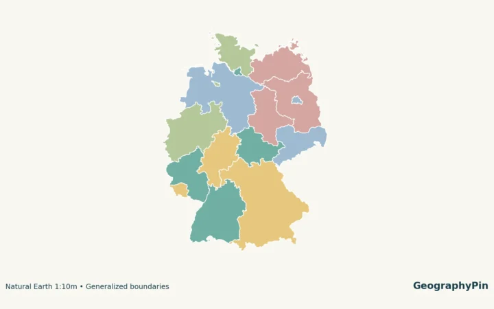
Eibsee lies in the municipality of Grainau, in Bavaria’s Garmisch-Partenkirchen district, southern Germany. Its setting is the northern side of the Zugspitze massif in the Wetterstein Mountains. The lake is below the mountain, not on its summit or on the high Zugspitzplatt plateau.
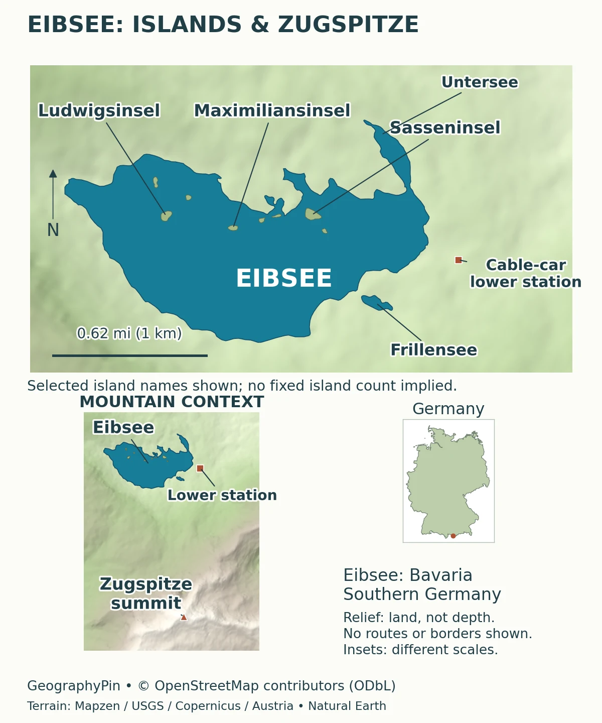
The lake, lower station and summit are different destinations
The German-side Zugspitze cable car starts beside Eibsee and reaches the summit area. The cogwheel railway is another part of the transport system: it runs via the Eibsee area toward the Zugspitze plateau, with the Gletscherbahn providing a further connection to the summit. A ticket or itinerary mentioning “Zugspitze” may therefore describe several locations rather than a single lakeside stop.
This distinction matters even if the mountain dominates your photograph. A view upward from the shore and a view down from the summit tell opposite stories about the same relief. To understand the scene, first locate the water, then the transport stations, and finally the mountain itself. A straight label leader on a locator is not a hiking route.
2. Eibsee Facts: Area, Depth and Elevation
The Weilheim Water Management Office (WWA) provides a concise reference profile of Eibsee. Its figures describe different parts of the lake system. The surface area tells you how much water appears on a map; the catchment is the larger surrounding area contributing water. Neither should be confused with a walking distance.
| Measurement | Reference value | Meaning |
|---|---|---|
| Mean surface elevation | About 3,193 feet (973.28 meters) | Height above the stated sea-level datum; not lake depth |
| Surface area | About 0.685 square miles (1.774 square kilometers) | WWA reference: 177.4 hectares |
| Maximum depth | About 116 feet (35.4 meters) | Deepest reported water, not typical shoreline depth |
| Catchment area | About 5.94 square miles (15.39 square kilometers) | Drainage-basin area, distinct from the lake’s surface area |
Reference values are not a survey made today
The district’s bathing-water profile, updated April 14, 2026, also lists a maximum depth of about 116 feet (35.4 meters), with rounded area and elevation values of about 0.68 square miles (1.77 square kilometers) and 3,192 feet (973 meters). The update date identifies the document; it does not establish that the entire lake was resurveyed that day.
The lake operator’s visitor page gives a different depth, about 107 feet (32.5 meters). That difference is left visible rather than averaged into a new number: the table follows the water authority and the district profile. A source can be useful for access information without being the chosen authority for every physical measurement.
3. An Older Lake Reshaped by a Rock Avalanche
The Bronze Age event crossed a lake that already existed
Eibsee’s landscape records more than one stage. Its basin belongs to a terrain shaped by glaciation, melting ice and rock debris. The older WWA description emphasizes postglacial rockfalls and debris around dead ice, with subsequent melting contributing to the uneven basin. That is a more complex history than a single clean excavation of bedrock.
The Bavarian Environment Agency (LfU) adds an important chronological distinction. Its 2018 geological announcement describes a large rock avalanche roughly 3,750 years earlier that crossed an already existing Eibsee. The moving material altered the lake and created islands and shallows. The event therefore helped shape the lake we see today; it should not automatically be treated as the date when water first occupied the basin.
A rock avalanche is a rapid movement of a large mass of broken rock down a slope. When that material enters a lake, it can interrupt a previously continuous basin, create submerged ridges and leave high points above the water. An island in such a setting is not necessarily the exposed summit of a mountain that predates the lake.
This is also why the age of a landform and the age of a basin need separate questions. The shoreline, islands and deeper hollows need not all have formed together. Compare the explanation of glacial erosion landforms: erosion, deposition and later slope failure can each contribute to the geography of one lake.
4. Islands, Untersee and Underground Drainage
Small rocky features make island counts less simple
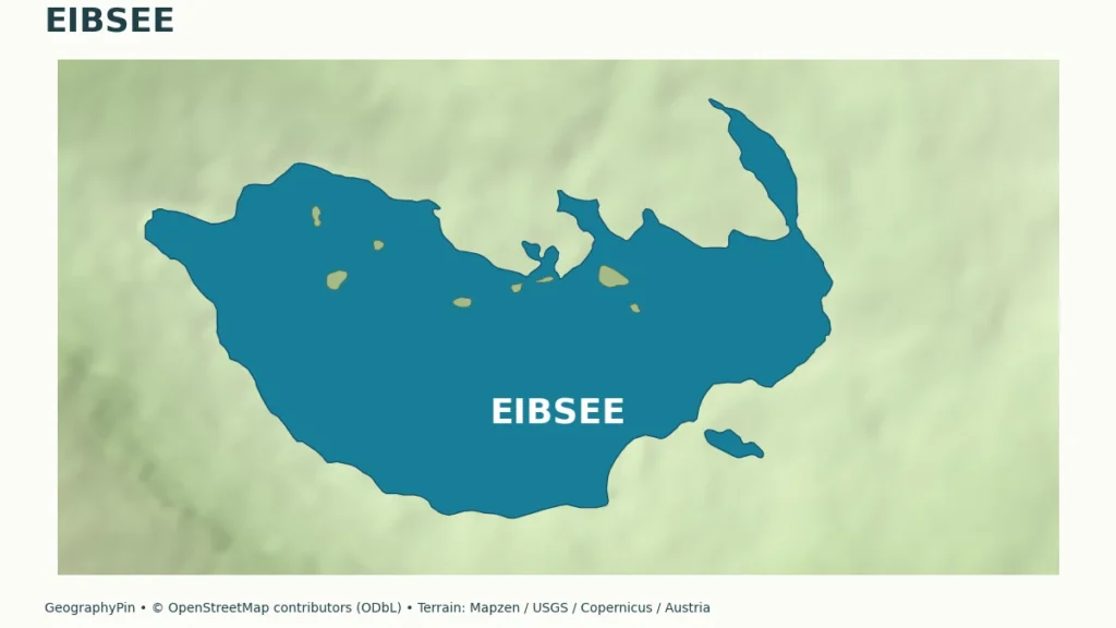
Grainau’s municipal place-name guide lists seven named islands, including Sasseninsel, Braxeninsel and Maximiliansinsel. It treats Steinbergle, also called Steinbühl, separately: this rocky rise is visible at low water but commonly submerged at higher water. The distinction is useful when comparing lists that do not count exposed rocks in the same way.
A map should therefore identify actual features rather than force every small patch of land into one fixed total. An island name may also have local alternatives. Those aliases describe the same place, not additional islands, so counting labels alone can produce a misleading result.
The same municipal guide explains that Untersee is separated from the main basin by a shallow threshold, with the Untersee bridge crossing above it. Water level affects whether this threshold is submerged. Untersee is consequently not just an unrelated nearby lake that happens to share a name; it is part of the connected basin geography at suitable water levels.
No surface outlet does not mean no water leaves
WWA identifies underground springs and the Kotbach as inflows, and underground seepage as the outlet. The district profile also names the Weiterbach and describes groundwater input from fractured karst terrain. Eibsee is called a Blindsee or Endsee because it lacks an above-ground outlet river.
Water can move through gaps and connected openings in rock or loose material without appearing as a visible stream on a map. The absence of an outlet line must not be interpreted as a sealed container, nor does the term imply a salt lake. The locator shows surface geography, not a measured reconstruction of underground flow paths.
5. Why the Water Looks Different Around the Shore
Color, transparency and depth answer different questions
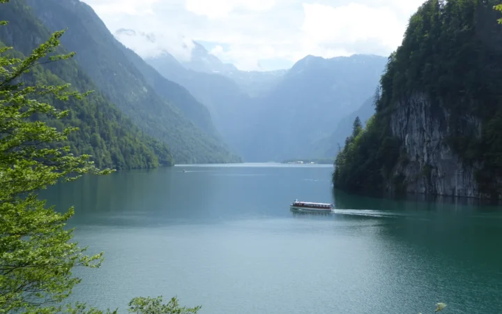
The attraction of Eibsee is partly the contrast between its open water, small islands, forested shore and high mountain backdrop. A shallow margin can look very different from deeper water nearby, especially where the bottom remains visible. Reflections, viewing direction, light and the appearance of the lake bed all affect a photograph; a particular blue or green shade is not a measurement of depth.
A useful way to read a lake image is to separate three observations. First, where is land exposed above water? Second, where can the bottom be seen? Third, where is the surface mainly reflecting the sky or mountains? These are visual clues, not enough information to draw a precise bathymetric contour or locate a safe entry point.
WWA characterizes Eibsee as nutrient-poor, using the term oligotrophic. That describes a lake’s nutrient and biological conditions rather than certifying every use of its water. For current bathing information, consult the district’s official bathing-lake information; do not turn a scenic photograph or an older water-quality description into a guarantee.
The shore is a boundary between water and land, not a uniform strip of beach. The district profile describes a mixture of rocky, stony and gravelly settings alongside other shore environments. Similar-looking positions around a small-scale map can therefore feel quite different on the ground. Islands, shallows and a broken shoreline are part of the lake’s physical character, not just decorative features.
6. Lake Walk or Mountain Trip? Planning the Right Visit
Choose a lakeside outing separately from the summit journey
The lake operator describes a circular shoreline route of about 4.7 miles (7.5 kilometers). That is a walking-route length, not the measured perimeter of the water or the distance to the Zugspitze summit. Route surfaces, conditions and personal pace matter more than treating a suggested duration as a promise.
For a lake-focused outing, the main geographic interest is the changing relationship between shore, islands and mountain views. For a summit trip, the important questions are instead the relevant railway or cable car, its operating status and the conditions at much greater elevation. Both can fit into a visit, but neither substitutes for planning the other.
Use the lake operator’s visitor information for the shoreline route and local facilities. For mountain transport, check the official operating times and maintenance notices. A published route description or year-round attraction does not mean every connection operates every day.
Finally, a lake in a mountain setting should be read at more than one scale. The detailed shoreline explains islands and nearby water; the wider map explains the Zugspitze relationship; the Germany locator explains the national setting. Keeping these scales distinct makes Eibsee more understandable than treating the lake, cable-car station and summit as interchangeable names.
What Did We Learn Today?
Eibsee is a lake below the Zugspitze, not a summit lake. Later rock-avalanche deposits reshaped an existing basin, while islands, shallow thresholds and underground drainage explain features that a scenic photograph alone can hide. Source-specific measurements and separate lake and mountain plans make its geography easier to understand.
Sources & Data Notes
US customary equivalents are rounded. Document dates do not automatically identify survey dates. Reference measurements, older geological interpretations and current visitor operations have different purposes; lake dimensions are not inferred from the illustrative map.
- WWA Weilheim: Eibsee lake profile. Reference dimensions, lake-basin description, underground springs and seepage, nutrient status. Publication date is not stated in the short profile.
- Garmisch-Partenkirchen district: Eibsee bathing-water profile. Updated April 14, 2026; the January 2025 wording is the form-template date. Pages 4–6 cover location, drainage, shore types and physical reference measurements.
- Bavarian Environment Agency: Eibsee rock avalanche. June 25, 2018 geological account explicitly describes the event crossing an existing lake and creating islands and shallows.
- Gemeinde Grainau: landscape and place-name guide. 2011 municipal guide, stations 37–40: island names, Steinbergle and the Untersee threshold. Upload-folder date is not the publication date.
- Eibsee operator: lake and visitor information. Circular-walk length, facilities and differing visitor-page depth reference.
- Bayerische Zugspitzbahn: Zugspitze round trip. Distinguishes cogwheel railway, plateau, summit, Gletscherbahn and Eibsee cable-car station.
Map sources and method: Original GeographyPin cartography uses complete OpenStreetMap lake and island geometry, selected named island polygons, and actual station and summit positions: © OpenStreetMap contributors, ODbL. Island names are checked against the Grainau guide; mapped exposure can vary with water level. Historical Mapzen elevation tiles supply surrounding land relief, not bathymetry. Global terrain data courtesy of the U.S. Geological Survey; European terrain produced using Copernicus data and information funded by the European Union – EU-DEM layers; Austrian terrain © offene Daten Österreichs, Digitales Geländemodell (DGM) Österreich. Exact per-tile source composition was not independently resolved; see Mapzen source attribution. The Germany locator uses Natural Earth public-domain data. The main map uses a latitude-adjusted geographic aspect and an approximate scale bar; insets have separate scales. No cableway route, national boundary or rock-avalanche footprint is drawn.