Germany’s geography is easy to oversimplify: Alpine scenery, industrial river valleys and northern beaches can look like separate countries. Reading its map from the two coasts toward the Alps reveals how lowlands, uplands and drainage basins fit together, and why the federal states are a different layer of geography.
Germany is a central European country bordered by nine countries, with North Sea and Baltic Sea coasts and an Alpine fringe in the south. Its main geographic contrast is between northern lowlands, central uplands and southern foothills and mountains. Berlin is the capital, and the country is organized into 16 federal states.
How to use this article: Find Germany’s nine neighbors, interpret the dated national figures, or compare Alpine landmarks with the major river routes.
1. Where is Germany?
Germany lies in central Europe, with the North Sea and Baltic Sea along its northern edge and a section of the Alps along its southern border. Its territory connects coastal lowlands with the mountain and river landscapes of inland Europe. Berlin, the capital, is in the northeast, not at the country’s geographic center.
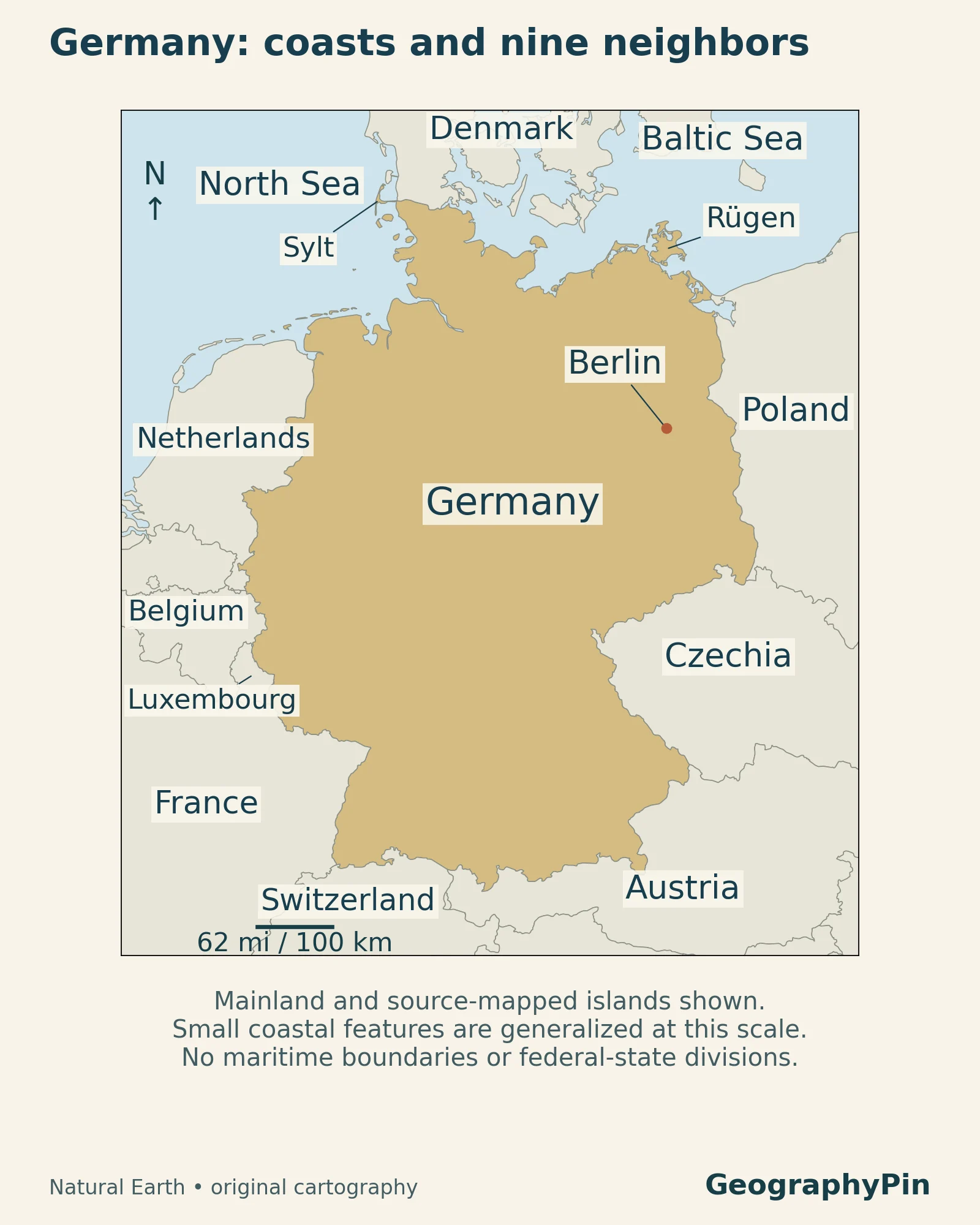
Nine neighbors, not nine regions
Starting in the north and moving clockwise, Germany borders Denmark, Poland, Czechia, Austria, Switzerland, France, Luxembourg, Belgium and the Netherlands. The locator separates these neighboring countries from Germany itself. Czechia and the Czech Republic refer to the same country.
Neither the seas nor the Alps make Germany an isolated unit. The North German Plain continues beyond its borders, while rivers connect it to countries upstream and downstream. This is why a country map is most useful when it includes some surrounding territory rather than ending exactly at the national boundary.
2. Country facts and the dates behind them
| Fact | Value and scope |
|---|---|
| Official name | Federal Republic of Germany; Bundesrepublik Deutschland |
| Capital | Berlin |
| Political structure | Federal parliamentary republic with 16 states |
| Population | 83,467,117 residents at December 31, 2025, based on the 2022 census |
| Area | About 138,102 square miles (357,683 square kilometers), 2024 land-use statistics |
| Highest mountain | Zugspitze: approximately 9,718 feet (2,962 meters) |
| Currency | Euro |
Why the dates and definitions matter
The population figure comes from Germany’s federal and state statistical offices. It counts residents, not only German citizens, and is a year-end estimate rather than a live population counter. An older figure based on a different census should not be treated as directly interchangeable.
Area also needs a definition. The German Environment Agency’s 2024 land-use total includes inland waters and certain near-coastal waters. It is not a land-only measurement. Other geographic-area series can differ slightly in coverage or reference year; those differences do not by themselves show that Germany’s borders moved.
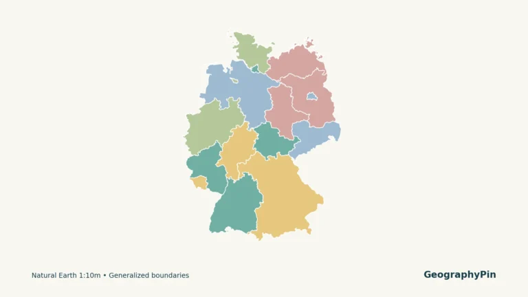
The 16 federal states are administrative units, not the physical regions described below. For their boundaries and capitals, use the separate Germany states map rather than trying to match each state to a single landscape.
3. The North German Plain and two coasts
The North German Plain, also called the North German Lowlands, stretches inland from the coasts. “Plain” does not mean uniformly flat: glaciation left low hills, ridges of deposited debris called moraines, lake basins and broad meltwater valleys. The German Environment Agency describes this mixture of lowlands and glacial landforms, rather than an uninterrupted level surface.
Sylt and Rügen: two different coastal settings
On the locator, Sylt sits on the North Sea side and Rügen on the Baltic side. They provide a quick way to distinguish the two coasts without confusing either island with an inland lake district.
Along the North Sea, the Wadden Sea is a shifting environment of tidal flats, channels, sandbanks and salt marshes. UNESCO describes a connected coastal ecosystem extending through the Netherlands, Germany and Denmark. Its visible shoreline changes with the tide, so the edge of blue water on a small map cannot represent every moment of the tidal cycle.
Farther inland, Berlin illustrates another important distinction: a major city can occupy a lowland region without being a coastal city. The lowlands explain the broad terrain around it, not its distance from the sea or the character of every neighborhood.
4. The central uplands and river valleys
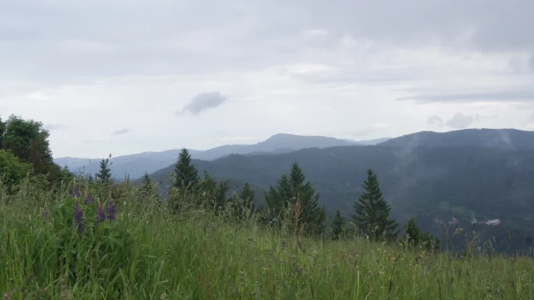
Germany’s middle is a mosaic of uplands, basins and valleys, not one continuous mountain chain. The term Mittelgebirge refers to its low mountain ranges. The Harz, for example, rises within this broader belt, while the Black Forest occupies the southwest beside the Upper Rhine valley.
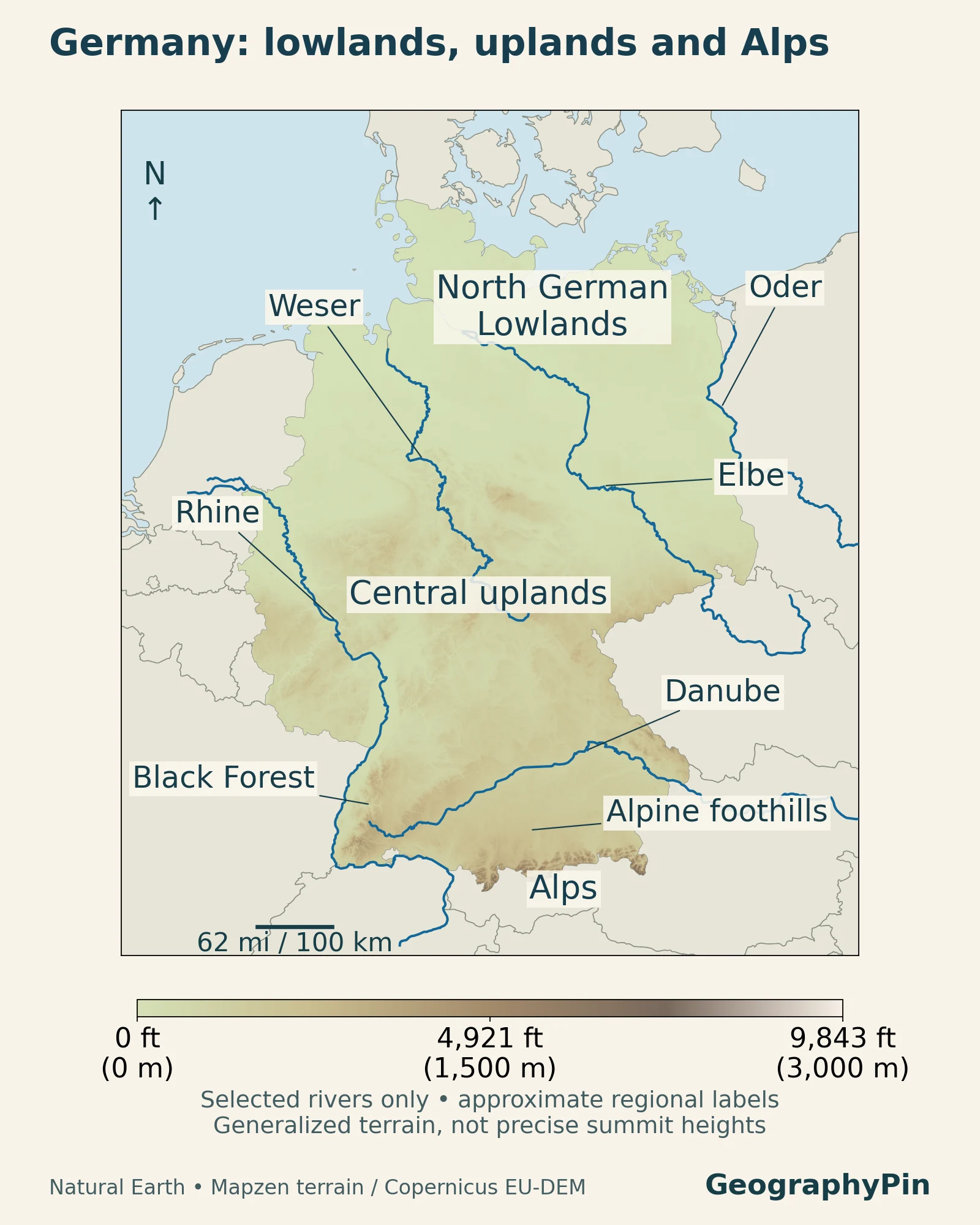
Read the relief map in two directions. North to south, compare the open lowlands with the more broken terrain in the central uplands and the Alpine edge. West to east, follow the valleys between higher areas. These contrasts explain why a simple statement such as “southern Germany is mountainous” misses substantial low corridors and basins.
The Black Forest is a useful example: it is an upland region, not part of the Alps. Its western edge faces the lower-lying Upper Rhine valley, so nearby places can occupy very different terrain. Forest cover and mountain relief are also different map layers; a green-looking landscape is not automatically flat, and a shaded relief map does not tell you which slopes are wooded.
5. The Alpine south and its lakes
The Alpine foothills form a transition between the uplands and the high mountains along Bavaria’s southern edge. They include rolling terrain and lake basins, while the Alps themselves occupy a relatively narrow southern fringe. Germany’s entire southern half should not be colored or described as Alpine.
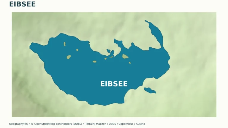
Zugspitze, Eibsee and Königssee
The Zugspitze, on the Austrian border, is Germany’s highest mountain at approximately 9,718 feet (2,962 meters). The Federal Agency for Cartography and Geodesy explains that precise heights depend on the national height reference system; rounding to the nearest meter avoids implying greater precision than this country overview needs.
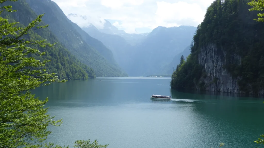
Eibsee, below the Zugspitze, and Königssee near Berchtesgaden give the Alpine landscape a different character from northern Germany’s lowland lakes. At Königssee, steep mountain walls closely enclose the water, as the featured photograph shows. The Bavarian Palace Administration describes the lake occupying the valley between the Watzmann and the mountains to its east.
Those examples are not interchangeable with the whole country. Comparing the northern islands, central Black Forest and southern Königssee is a more useful mental picture than choosing either a mountain photograph or a city skyline as representative of every German region.
6. Rivers draining toward three seas
Germany has coastlines on two seas, but its river drainage connects it to three. A drainage basin is the area from which water reaches a particular river and its outlet. It can cross national borders and need not correspond to a federal state.
| System | Geographic connection | Sea |
|---|---|---|
| Rhine | Swiss Alps, western Germany and the Netherlands | North Sea |
| Elbe | Czechia, eastern and northern Germany | North Sea |
| Weser and Ems | Separate river systems in northwestern Germany | North Sea |
| Oder | Eastern drainage toward the Baltic | Baltic Sea |
| Danube | Southern Germany and downstream central and southeastern Europe | Black Sea |
Why the Danube goes a different way
The Rhine begins in the Swiss Alps and reaches the North Sea through the Netherlands. Germany’s western river corridor is therefore one section of an international system, not a river wholly contained in Germany. The Rhine river map follows the wider route.
The Elbe starts in Czechia’s Giant Mountains and reaches the North Sea near Cuxhaven. By contrast, the Danube forms where the Breg and Brigach meet near Donaueschingen and continues eastward toward the Black Sea. Germany’s mountains and drainage divides, not simply the nearest coastline, determine these different destinations.
River length is another scope trap. Comparing entire international rivers produces a different answer from comparing only their German stretches. The map is designed to explain routes and drainage, not to rank rivers by a mixture of those two measurements.
7. Climate: Atlantic influence, continental contrasts
Germany lies in the temperate zone between Atlantic maritime influences and more continental conditions farther east. The German Weather Service describes a transition, not a sharp climatic boundary running through the country.
Moist Atlantic air moderates conditions, while continental air can bring colder winters or hotter summers. Elevation and exposure add local contrasts: uplands and Alpine areas generally receive more precipitation than lower terrain, and windward slopes can differ from sheltered valleys. Rainfall occurs throughout the year rather than following one nationwide dry season.
These patterns help explain why a weather description for northern lowland Hamburg cannot stand in for a high Alpine location. They are long-term geographic tendencies, not a forecast or a promise of snow. A particular wet summer, dry month or heatwave also cannot, on its own, describe the country’s whole climate.
8. Population, cities and languages
Germany’s population is distributed across many urban regions. The federal Deutschlandatlas shows dense concentrations along parts of the western urban belt, including the Ruhr, Rhine-Main and Stuttgart regions. Much of the northeast is more sparsely settled, with Berlin and its surrounding area a clear exception.
This pattern is not captured by naming only the capital. Berlin is a separate federal state, as are Hamburg and Bremen; the remaining states contain many towns, cities and rural districts. A city population, a metropolitan-region population and a state population describe different geographic units and should not be compared as though they were equivalent.
German and regional language communities
German is the principal nationwide language, but the linguistic map is not uniform. Protected minority languages include Danish, North and Sater Frisian, Upper and Lower Sorbian, and Romani; Low German is protected as a regional language. The Minority Secretariat places the Danish community near the Danish border and the Sorbian communities in Lusatia, in Saxony and Brandenburg.
These are examples of long-established communities, not a complete account of languages spoken by residents today. Citizenship, language and cultural identity are different categories; the national population total should not be read as a count of one ethnic or language group.
9. The economy in its geographic setting
Germany’s economic geography is similarly multi-centered. Facts about Germany identifies major centers around the Ruhr, Munich and Stuttgart, the Rhine-Neckar region, Frankfurt and Hamburg. Their specialisms differ: Frankfurt is a financial center, Munich and Stuttgart are associated with high-tech and automotive industries, and Hamburg combines port activity with aircraft construction.
The geographic links matter as much as the city names. Hamburg’s port connects with the North Sea through the Elbe, while the Rhine corridor connects industrial and commercial regions across borders. Rivers are both working transport routes and environments that require cross-border management; the physical map helps explain the connection without reducing economic success to terrain alone.
Nor is Germany’s land surface mostly urban. In the German Environment Agency’s 2024 land-use account, agriculture occupied 50.2% and forests 29.9%. Settlement and transport occupied 14.6%, a category that also includes such uses as recreation areas, not only buildings and paved roads. The contrast between heavily connected urban regions and extensive cultivated or wooded land is central to understanding the country.
Frequently Asked Questions
Are Germany and Deutschland different places?
No. Deutschland is the German name for Germany. Bundesrepublik Deutschland is the German form of its official name, Federal Republic of Germany.
Are East Germany and West Germany still separate countries?
No. Germany was reunified on October 3, 1990. Those names refer to the former divided states or, in some modern discussions, to regional and historical differences within the same country.
What Did We Learn Today?
Germany makes more sense when several maps are kept distinct: its national border and federal states, its lowlands and mountains, its river basins, and its population centers. The north-to-south terrain contrast is a useful starting point, but river valleys and urban regions cut across that simple pattern. Dates and measurement definitions keep the country facts consistent with the geography.
Sources & Data Notes
Population refers to year-end 2025 and the present Federal Republic; area and land-use shares use the German Environment Agency’s 2024 account. Square miles and feet are rounded conversions. Older environmental reports support stable landscape and climate explanations, not current rainfall averages or current water quality. Maps generalize geography for orientation and show selected river systems, not every tributary or official landscape boundaries.
- Federal and state statistical offices: population by state, 2025
- German Environment Agency: land use and area, 2024
- European Union: Germany, political structure and currency
- German Environment Agency: Water Resource Management in Germany, 2018, natural conditions
- UNESCO: Wadden Sea
- German Weather Service: National Climate Report, climate setting
- Deutschlandatlas: population-density patterns, 2024
- Minority Secretariat: recognized communities and protected languages
- Facts about Germany: regional economic centers
- Federal Institute of Hydrology: Rhine, Elbe and Danube basin descriptions; German Environment Agency river-system overview; Weser and its headstreams.
Additional geographic references: Germany’s neighbors; BKG height references for the Zugspitze; Bavarian Palace Administration on Königssee; Federal Government chronology of reunification.
Map credits: GeographyPin; Natural Earth geographic data; Mapzen terrain. Europe terrain data produced using Copernicus data and information funded by the European Union – EU-DEM layers. Featured photograph: Rosa-Maria Rinkl, Königssee, Berchtesgaden, CC BY 4.0; cropped, resized and converted to WebP.