The Red Sea is connected to the ocean, yet its water is unusually salty. That makes it a useful contrast with a closed salt lake: it loses freshwater to the atmosphere, but it also exchanges water through a narrow marine gateway. To understand the saltiness, follow both parts of that story rather than imagining a sealed basin slowly drying out.
The Red Sea is unusually salty because evaporation removes freshwater while rainfall and river runoff provide little dilution. Water exchanged through Bab el-Mandeb replaces much of the loss and exports saltier water. It is therefore an actively exchanging marine basin, not a closed salt lake, and its circulation changes with the seasons.
How to use this article: Start with concentration, compare seasonal exchange, and interpret salinity values.
1. Evaporation concentrates salt that is already present
Separate the water balance from the origin of salt
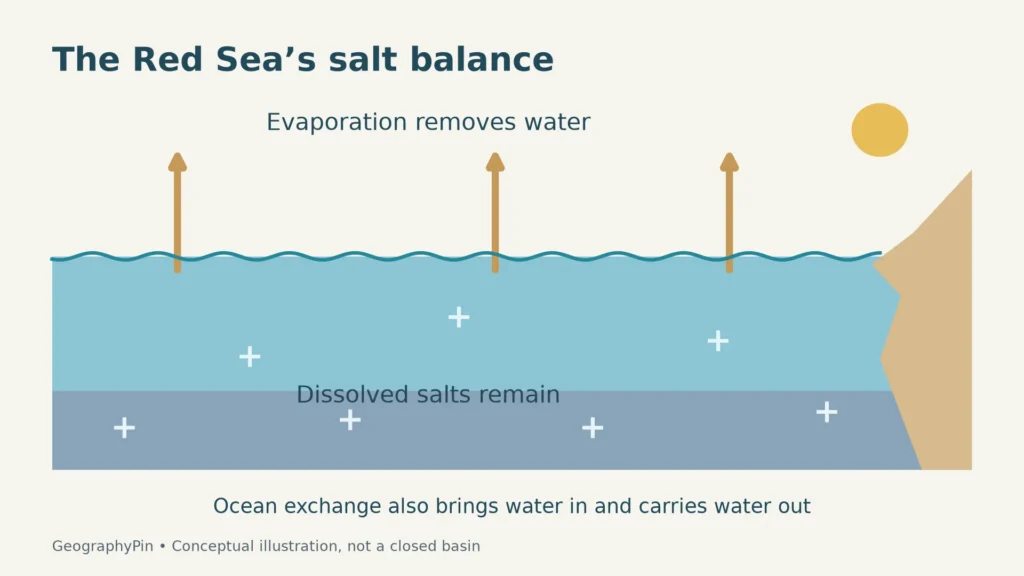
When water evaporates, most dissolved salts remain in the sea. Removing water while retaining dissolved material raises the concentration. Evaporation therefore explains why a particular body of seawater can become saltier; it does not manufacture the salt itself.
Ocean water already contains dissolved ions supplied through processes such as rock weathering and exchanges with the seafloor. Water entering the Red Sea is consequently seawater, not fresh water waiting to be salted. The regional question is why the concentration becomes higher than in the water entering from outside.
The Red Sea is surrounded by arid land. Freshwater input from rainfall and river runoff is small compared with evaporation. Large, permanently flowing rivers do not deliver the kind of dilution that major rivers provide to some other seas. This does not mean that rain never falls or that a coastal wadi can never carry runoff; it describes the dominant basin-scale balance.
A useful distinction is net freshwater loss. Rain adds water, evaporation removes it, and runoff may add more. What matters to salinity is the combined effect, not simply whether the sun is strong on a particular afternoon. Wind, humidity and the temperature contrast between the sea and air also influence evaporation.
The sea does not need to shrink for concentration to occur
An open connection changes the outcome. Water imported from the Gulf of Aden helps replace the net loss to the atmosphere. At the same time, saltier water leaves the Red Sea. The basin’s water level and salt content therefore depend on exchange as well as evaporation.
This is why “evaporation makes water saltier” should not become “the Red Sea is turning into a dry salt pan.” The first describes a process; the second ignores circulation. The sea is not a closed-container experiment, even though a small-container analogy can help explain concentration.
2. Bab el-Mandeb connects the salty basin to the ocean
Locate the southern gateway before following the currents
The Red Sea lies between northeastern Africa and the Arabian Peninsula. Its main natural ocean connection is at the southern end, through Bab el-Mandeb into the Gulf of Aden and the wider Indian Ocean system. The strait constrains exchange, but it does not prevent it.
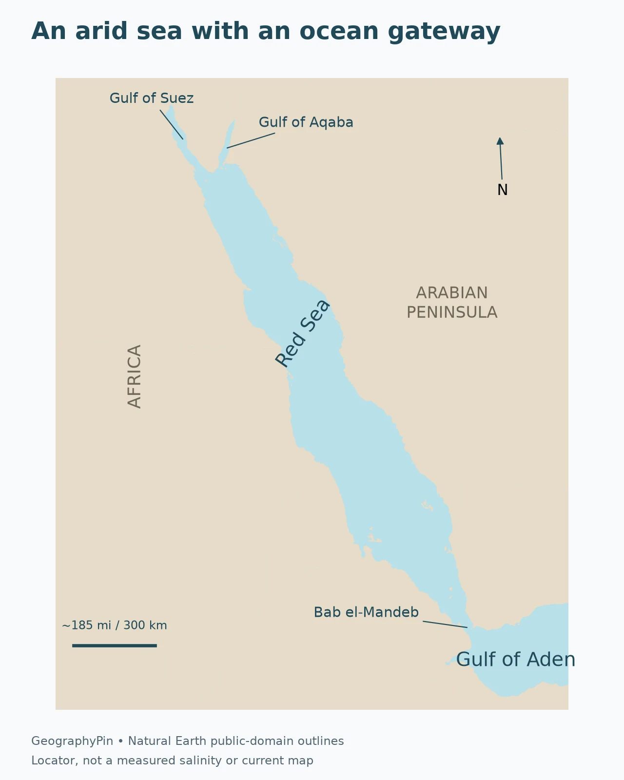
The northern branches are different connections. The Gulf of Aqaba is a northeastern arm, while the Gulf of Suez leads toward the Suez Canal and Mediterranean. Water exchange also occurs through the canal, so it is inaccurate to say that no water can enter or leave anywhere except Bab el-Mandeb. The southern strait is the key gateway in the basin-scale circulation discussed here.
For the full coastline and country context, use our Red Sea map. The locator here concentrates on the connection relevant to salinity. It does not shade a measured salt gradient or depict a real-time current field.
Inflow and outflow can happen together
A narrow strait is not necessarily a one-way channel. Water can move in different directions at different depths. Differences in water properties and pressure, combined with winds and the shape of the passage, help organize this exchange.
In the commonly described winter pattern, relatively less-salty surface water enters from the Gulf of Aden while saltier Red Sea water leaves below it. “Less salty” is the important wording: the incoming water is still seawater. Calling it freshwater would imply a very different balance.
3. The gateway changes its vertical pattern with the seasons
Compare winter and summer without treating them as fixed dates
Research on Bab el-Mandeb distinguishes a typical two-layer winter exchange from a three-layer summer arrangement. In summer, the surface layer can flow outward, a cooler and relatively less-salty intermediate layer enters from the Gulf of Aden, and a weaker salty outflow remains below.
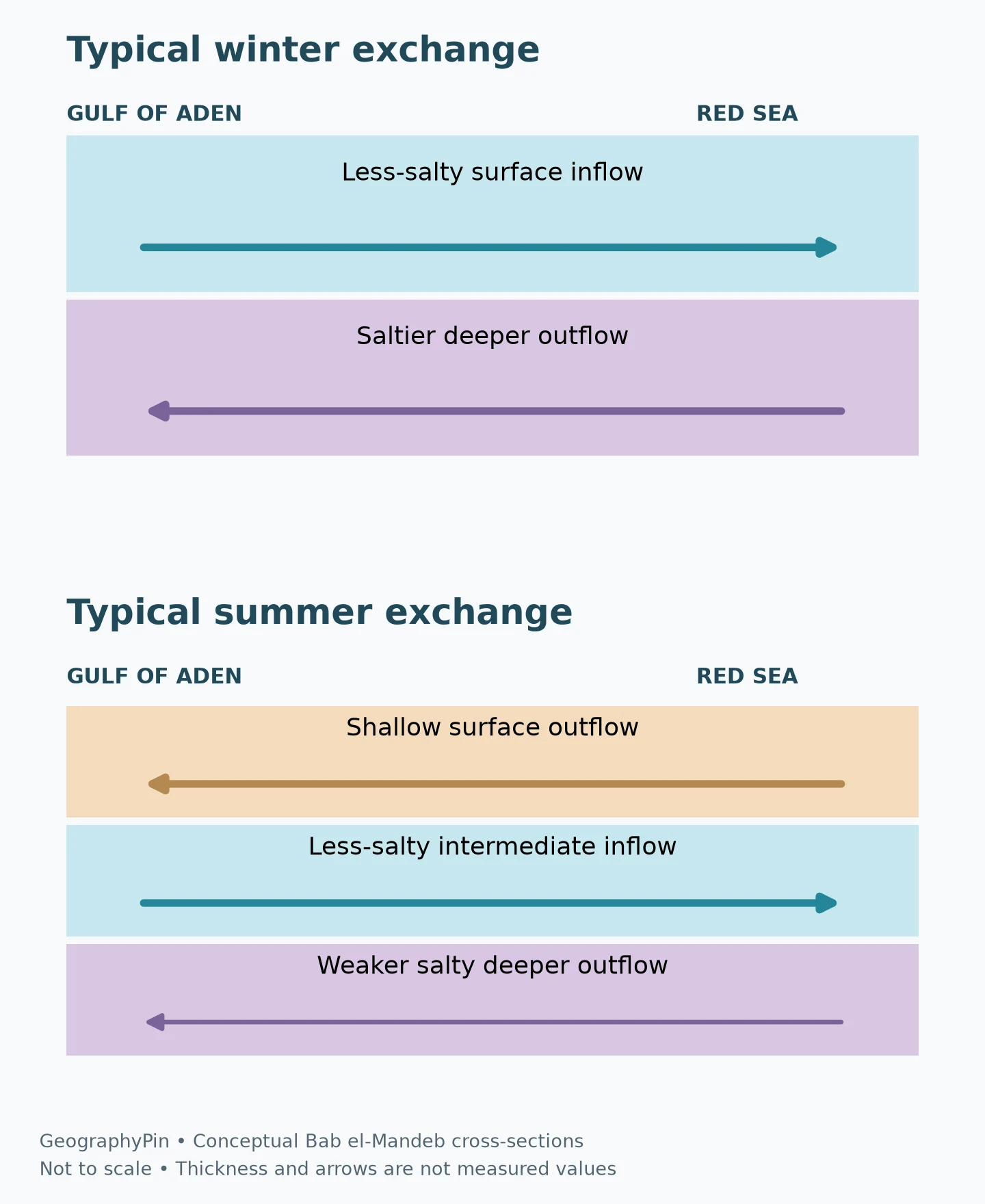
The illustration shows direction and relative vertical order, not exact layer thickness or flow rate. In particular, the summer inflow does not mean that every depth reverses direction together. A surface-current arrow alone cannot describe the whole passage.
A 2019 study by Xie and colleagues combined a high-resolution simulation with observational comparisons. It found substantial year-to-year variability in the onset and duration of the two seasonal patterns. The monsoon-related wind changes matter, but a diagram should not assign one unchanging switch date to every year.
This seasonal structure also explains why a simplified “surface in, deep out” picture is useful but incomplete. It describes the familiar winter arrangement, not a permanent law for every month. Labels such as winter pattern and summer pattern are part of the scientific information, not optional decoration.
| Exchange setting | Upper water | Intermediate water | Deeper water |
|---|---|---|---|
| Typical winter pattern | Inflow toward the Red Sea | Not a separate third exchange layer in this simplified view | Saltier outflow toward the Gulf of Aden |
| Typical summer pattern | Shallow outflow | Relatively less-salty inflow | Weaker salty outflow |
The three-layer pattern is a description of the strait exchange, not a claim that the entire Red Sea consists of three uniform horizontal sheets. Inside the basin, circulation includes boundary currents, eddies and mixing. Those processes redistribute water and keep a single textbook cross-section from being a complete ocean map.
4. How salty is the Red Sea, and why does location matter?
Use reference values without turning them into a new survey
PERSGA’s State of the Marine Environment Report for the Red Sea and Gulf of Aden (2006) gives a broad reference contrast of about 37‰ near Bab el-Mandeb and 41‰ near the northern entrances to the gulfs of Suez and Aqaba. These are regional overview values from that report, not measurements made today or a guaranteed reading at every beach.
The contrast illustrates the general increase toward the north as evaporation and circulation modify the incoming water. It should not be read as a perfectly smooth gradient: depth, season, local conditions and water-mass movements also affect salinity.
| Reference location | Value reported in the 2006 regional overview | How to read it |
|---|---|---|
| Bab el-Mandeb region | About 37‰ | Southern gateway context, not freshwater |
| Northern Red Sea near the gulf entrances | About 41‰ | Broad northern reference, not a uniform value for both entire gulfs |
The symbol ‰ means parts per thousand. It is not percent: 40 parts per thousand is not 40 percent. Oceanographic research may instead report Practical Salinity, often written with “psu,” or Absolute Salinity in grams per kilogram. These conventions are related, but they should not be silently substituted for one another in a technical comparison. Grams per liter introduces a volume basis and is another distinct quantity.
The table preserves the original report’s notation rather than converting its numbers into a supposedly more precise modern measurement. To compare a new observation with it, check the measurement convention, location, depth and date first.
Temperature and salinity both affect density
Salinity helps influence seawater density, but it is not the only control. Cooling can also increase density. Research on Red Sea Outflow Water connects winter buoyancy loss in the northern basin with the formation and spreading of denser water toward the southern outlet.
This matters because “saltier water sinks” is an incomplete description of the circulation. The temperature history and mixing of a water parcel also matter. A warm, salty sample and a cooler, less-salty sample cannot be ranked reliably by salinity alone without considering their other properties.
5. Why the Red Sea is not the Dead Sea
Compare an exchanging sea with a closed salt lake
The similar names can hide a major geographic difference. The Red Sea is a marine basin connected to the ocean. The Dead Sea is an inland lake without a natural outlet to the world ocean. Evaporation matters to both, but their exchange pathways are fundamentally different.
| Question | Red Sea | Dead Sea |
|---|---|---|
| Geographic type | Semi-enclosed marine basin | Inland hypersaline lake |
| Natural ocean connection | Bab el-Mandeb to the Gulf of Aden | None |
| Does ordinary seawater enter and saltier water leave through a marine strait? | Yes, with a seasonal exchange structure | No |
| Can their salinity figures be compared without checking units? | No | No |
Table downloads (3)
- Simplified seasonal exchange patterns at Bab el-Mandeb (3 × 4)View tableDownload CSV
- Regional salinity references reported in the 2006 overview (3 × 3)View tableDownload CSV
- Red Sea and Dead Sea: geographic and hydrological differences (5 × 3)View tableDownload CSV
Our Dead Sea explanation separates its natural lake, managed evaporation ponds and salinity measurement conventions. It is not a model for Red Sea circulation, and the Red Sea’s name should not be taken as evidence of a natural connection between the two.
The Red Sea is notably saline, but “the saltiest water on Earth” is not a defensible blanket description. Small hypersaline lakes and exceptional deep brines are different categories from the ordinary water of an ocean-connected sea. A ranking that mixes all of them loses the meaning of the comparison.
Frequently Asked Questions
Is the Red Sea saltier than ordinary seawater?
Yes, it is notably saline. A 2006 PERSGA regional overview gives about 37 parts per thousand near Bab el-Mandeb and 41 near the northern gulf entrances. Those are broad reference values, not a single modern measurement for every location.
Does freshwater flow into the Red Sea from the Gulf of Aden?
No. The incoming water is seawater. It is relatively less salty than the water exported from the Red Sea, which is not the same as being fresh.
Does water always flow into the Red Sea at the surface?
No. That is characteristic of the typical winter two-layer exchange. The summer pattern can have surface outflow, intermediate inflow and weaker deeper outflow.
Is the Red Sea connected to the Dead Sea?
There is no natural water connection between them. The Red Sea exchanges with the ocean, while the Dead Sea is a closed inland lake.
What Did We Learn Today?
The Red Sea’s saltiness reflects evaporation, limited freshwater dilution and continued ocean exchange. Bab el-Mandeb links the basin to the Gulf of Aden, but its vertical flow pattern changes with the seasons. Keeping water balance, salinity units and geographic connections separate explains why this salty sea is neither a sealed lake nor a uniform body of water.
Sources & Data Notes
This is a process explanation, not a new salinity survey or a current forecast. The 37‰ and 41‰ values retain the notation and regional scope of PERSGA’s 2006 overview. Seasonal exchange is based on published observations and modeling; no exact annual onset date, transport rate or fixed layer depth is asserted. The locator uses Natural Earth geometry. Original conceptual graphics do not copy a source figure or portray measured salinity boundaries.
- Xie et al. (2019): Interannual Variability of the Exchange Flow Through the Strait of Bab-al-Mandeb
- Zhai et al. (2015): Formation and spreading of Red Sea Outflow Water in the Red Sea
- Woods Hole Oceanographic Institution: Mysteries of the Red Sea
- Woods Hole Oceanographic Institution: What makes the ocean salty?
- PERSGA (2006): State of the Marine Environment Report, sections 2.4.5–2.5.1
- TEOS-10: Practical and Absolute Salinity conventions
- Natural Earth: public-domain map data