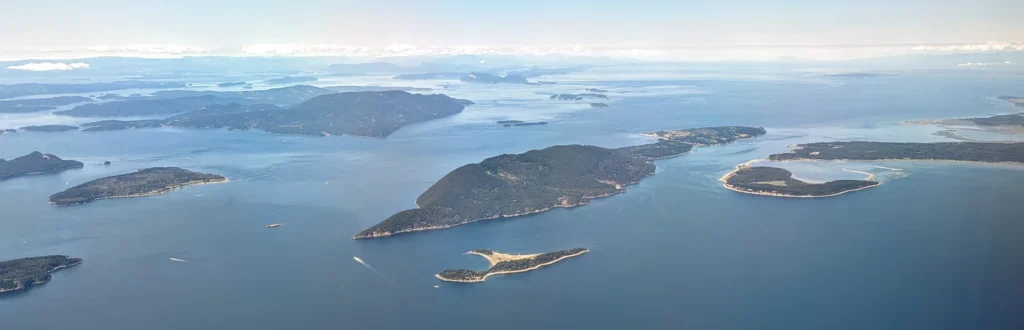
Lummi Island sits close to the Washington mainland, but its place names can send a first-time visitor toward the wrong shore. The island, the Lummi Nation and the mainland ferry landing are related places, not interchangeable destinations.
Where is Lummi Island, Washington?
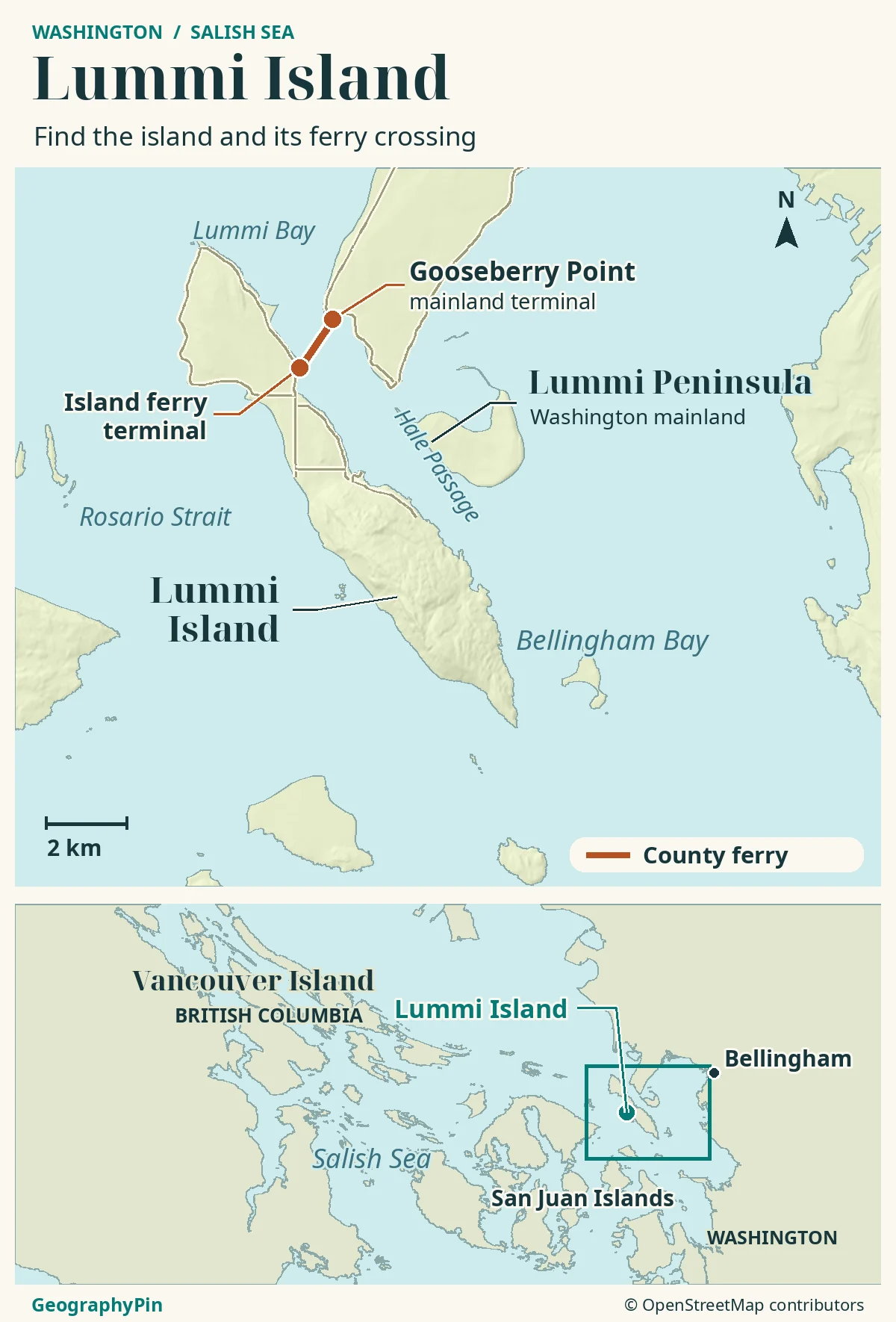
Lummi Island is in the Salish Sea off northwest Washington, west of Bellingham, in Whatcom County. Hale Passage separates it from the mainland at Gooseberry Point. The county ferry crosses that passage to the island’s east shore; it is not part of the state ferry routes from Anacortes to the San Juans.
How to use this article: Identify the crossing waterway, separate the island and Nation, and make your ferry checks.
Lummi Island on the Salish Sea map
Lummi Island lies off the northwest Washington mainland, west of Bellingham and south of the Canadian border. Its local setting is easier to understand by following the water: Rosario Strait is to the west, Bellingham Bay is to the east, and Hale Passage separates the island from the Lummi Peninsula and the mainland ferry landing.
The Salish Sea is the larger connected marine system shared by Washington and British Columbia. It includes Puget Sound, the Strait of Georgia and the Strait of Juan de Fuca, along with their connecting waters. Calling Lummi a Salish Sea island places it in that wider system; it does not mean the ferry crosses the entire sea.
Hale Passage is the ferry crossing, not Lummi Bay
The short crossing links Gooseberry Point with the island’s east shore across Hale Passage. Lummi Bay is another named water body, along the west side of the mainland Lummi Peninsula farther north. The names are close together on a regional map, but they are not interchangeable ferry destinations.
For broader national context, see the United States country profile and map. Here, the useful scale is much closer: two ferry landings, the narrow passage between them and the roads feeding each landing.
Island, county and Lummi Nation are different labels
Lummi Island belongs to Whatcom County, not San Juan County. Whatcom County’s 2009 subarea plan describes it as the easternmost part of the San Juan island chain, which explains why regional island descriptions can place it with the San Juans. That geographic grouping does not determine its county government or ferry operator.
Do not confuse the island with the Lummi Nation
The Lummi Nation is a self-governing Indigenous nation within the United States, not another name for an island settlement. Its reservation lies west of Bellingham and south of Ferndale. The Nation’s own maps distinguish the mainland peninsula, Lummi Bay, Hale Passage and nearby islands.
Whatcom County’s 2025 ferry operating review, published in 2026, separates its island terminal from the Gooseberry Point terminal on land leased from the Lummi Nation. The shared place name should not be used to draw a single boundary around the island, reservation and surrounding traditional territory. Those are different geographic and political concepts.
| Name | What it identifies |
|---|---|
| Lummi Island | The offshore island and its community in Whatcom County. |
| Gooseberry Point | The mainland end of the county ferry crossing. |
| Lummi Nation | A sovereign Indigenous nation, not a synonym for Lummi Island. |
| Hale Passage | The water crossed by the ferry between the mainland and island. |
Getting across from Gooseberry Point
The normal vehicle-and-passenger link is the Whatcom Chief, operated by Whatcom County. It is not an Anacortes departure on Washington State Ferries’ San Juan routes. For a road trip to Lummi Island, set the mainland destination to Gooseberry Point ferry terminal, not a general Bellingham waterfront address.
The county’s published driving directions use Interstate 5’s Slater Road exit, then Slater Road and Haxton Way toward the ferry. Check road conditions and the terminal approach before departure rather than assuming a map app’s island arrival time includes the wait to board.
Check the crossing and your return separately
Whatcom County describes the routine crossing as about five minutes. That is time on the water, not the total time required to reach the island: approach traffic, the queue, loading and waiting for another sailing can add to it. The service is first come, first served, with no reservations; the county also states that it does not accept cash payments.
Use the county’s current schedule and service notices for your date, including your return. Dry dock and repairs can replace the vehicle ferry with passenger-only service or interrupt the crossing during changeovers. Do not apply a passenger-only timetable to a trip with a car, or treat an older seasonal notice as a future promise.
If walking aboard, arrange how you will reach your actual island destination before crossing. The landing is an arrival point, not a promise that a beach, trailhead or accommodation is within an easy walk.
The island’s roads, hills and shore
The island has a lower northern portion and a much more mountainous southern portion. That contrast helps explain why a map showing only the shoreline can be misleading: two places that look close together may be separated by steep ground rather than a convenient public trail.
The physical landscape includes both older bedrock and deposits left by glaciation. A geological assessment prepared for the Lummi Island Heritage Trust describes widespread glacial sediments in the northwest and exposed bedrock beneath surface soils in the southeast. It is not simply a low sand island or a single uniform landform.
Follow the mapped island roads to your destination rather than assuming a complete public route around the shore. In particular, a road near the coast is not evidence that the land between it and the water is open to visitors.
The county’s Lummi Island Beach Access at 2198 North Nugent Road is a useful named public place to distinguish from the active ferry terminal. It occupies a former ferry landing and has an observation deck overlooking Hale Passage, with access to the tidelands below. Search its full park name if that is the destination you want.
Public access is specific, not island-wide
A coastal outline identifies land and water, not permission to enter every shore, driveway or trail. Plan around named public access points and the land manager’s directions. Do not use the ferry connection as a reason to assume that nearby reservation land, tidelands or private island property is freely accessible.
Baker Preserve is an example of managed access rather than unrestricted countryside. The Lummi Island Heritage Trust requires visitors to sign in at the trailhead and stay on its trails. Its rules allow foot travel during daylight and prohibit dogs, bicycles, camping and drones. The trail climbs steep terrain; choose it as a hike, not as a casual shortcut to the coast.
The nearby state wildlife area also restricts access to the designated approach from the east through the Heritage Trust parking area and trail. Washington Department of Fish and Wildlife describes steep, rocky ground and foot-only use, with no dogs. A green patch on a map should never be read as a network of routes open from every direction.
Choose a named public site
| Site | Setting | Important distinction |
|---|---|---|
| Baker Preserve | Steep forest trail to a designated overlook. | Sign in; no dogs. The visitor route is not permission to continue to a summit. |
| Otto Preserve | Forest walking, with a main loop and connecting paths. | Foot travel only; dogs must be leashed. |
| Curry Preserve | Gentle paths through fields, forest and wetlands. | Stay on trails; dogs must be leashed. |
| Aiston Preserve | Forested slopes and designated routes near Smuggler’s Cove. | Use the Heritage Trust’s mapped entrances and trails, not informal shortcuts. |
| Lummi Island Beach Access | Former ferry-landing overlook at 2198 North Nugent Road. | A county park, not today’s ferry terminal; published hours are 8 a.m. to dusk. |
| Sunset Beach Access | Shared beach and adjoining public tidelands on West Shore Drive. | Use the designated county access; published hours are 8 a.m. to dusk. |
Before leaving the mainland, match three things: the ferry service operating that day, the exact destination you intend to visit and its access rules. That is more useful than a list of island attractions without a way to reach them responsibly.
Frequently Asked Questions
Where does the Baker Preserve visitor trail lead?
The Heritage Trust describes its visitor trail as reaching an overlook. Treat that designated overlook as the hike’s destination, not as permission to continue across other land in search of a summit.
Can I get a ferry ticket at the county’s Bellingham office?
The county specifically tells customers not to visit its Civic Center office in Bellingham for ferry tickets because it does not sell them there in person. Consult its ferry page for payment arrangements before travel.
What Did We Learn Today?
Lummi Island’s useful map is both physical and practical: the island on one side of Hale Passage, Gooseberry Point on the other, and a county ferry connecting them. Regional island names do not replace county boundaries, and an accessible landing does not make every shoreline or mountain route public.
Sources & Data Notes
Sources checked November 19, 2026. Older planning and geological documents support stable physical context, not current population, road conditions or visitor services. Ferry information describes the operator and crossing; no live sailing, fare or future maintenance date is guaranteed. The map is an orientation aid, not a marine chart, property survey or access-permission map.
- Whatcom County: Lummi Island Subarea Plan, May 2009
- Western Washington University: Salish Sea and surrounding basin
- Lummi Nation: About Us
- Lummi Nation: reservation reference map, Exhibit A
- Whatcom County: 2025 ferry operating review, published June 2026
- Whatcom County: ferry service and current notices
- Whatcom County: regular ferry schedule and boarding rules
- Whatcom County: dry dock and changeover arrangements
- Whatcom County: mainland driving approach
- Environmental site assessment for Lummi Island Heritage Trust, September 2015: physical geology
- Whatcom County: Lummi Island Beach Access park
- Lummi Island Heritage Trust: Baker Preserve access rules
- Washington Department of Fish and Wildlife: Lummi Island unit
- Heritage Trust: Otto Preserve
- Heritage Trust: Curry Preserve
- Heritage Trust: Aiston Preserve
- Whatcom County: Sunset Beach Access
Original map: GeographyPin. Coastline from OpenStreetMap land polygons, November 18, 2026, and mapped ferry and road data retrieved November 19, 2026, © OpenStreetMap contributors, ODbL. Actual shaded relief from Mapzen Terrain Tiles, with underlying terrain-source attribution. Ferry terminal identity checked against Whatcom County information and mainland directions. The ferry line is for orientation, not marine navigation; selected roads are shown without jurisdiction boundaries.
Photograph: Lummi Island and vicinity in Bellingham Bay, Dicklyon, June 30, 2023, CC BY-SA 4.0. Resized and converted to WebP without cropping; derivative under the same license.
