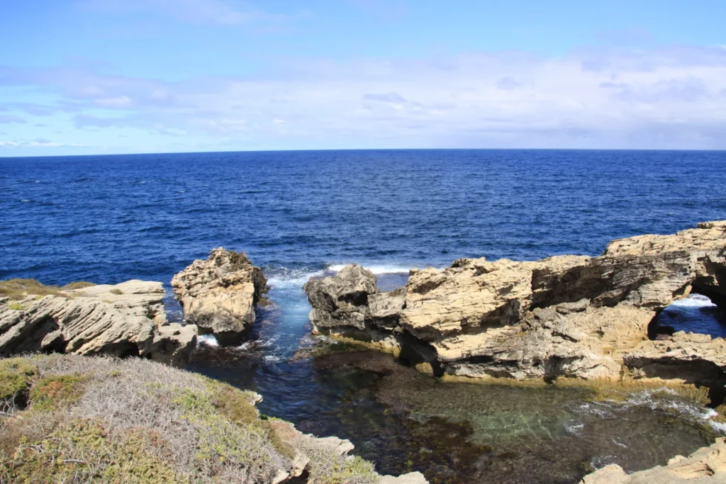
A ferry from the mainland reaches Wadjemup at Thomson Bay, where the coast opens toward Fremantle. Inland are salt lakes, and at the other end of the island, limestone cliffs meet the open Indian Ocean. Those three places show how differently water has shaped the same island.
Wadjemup lies just off Fremantle
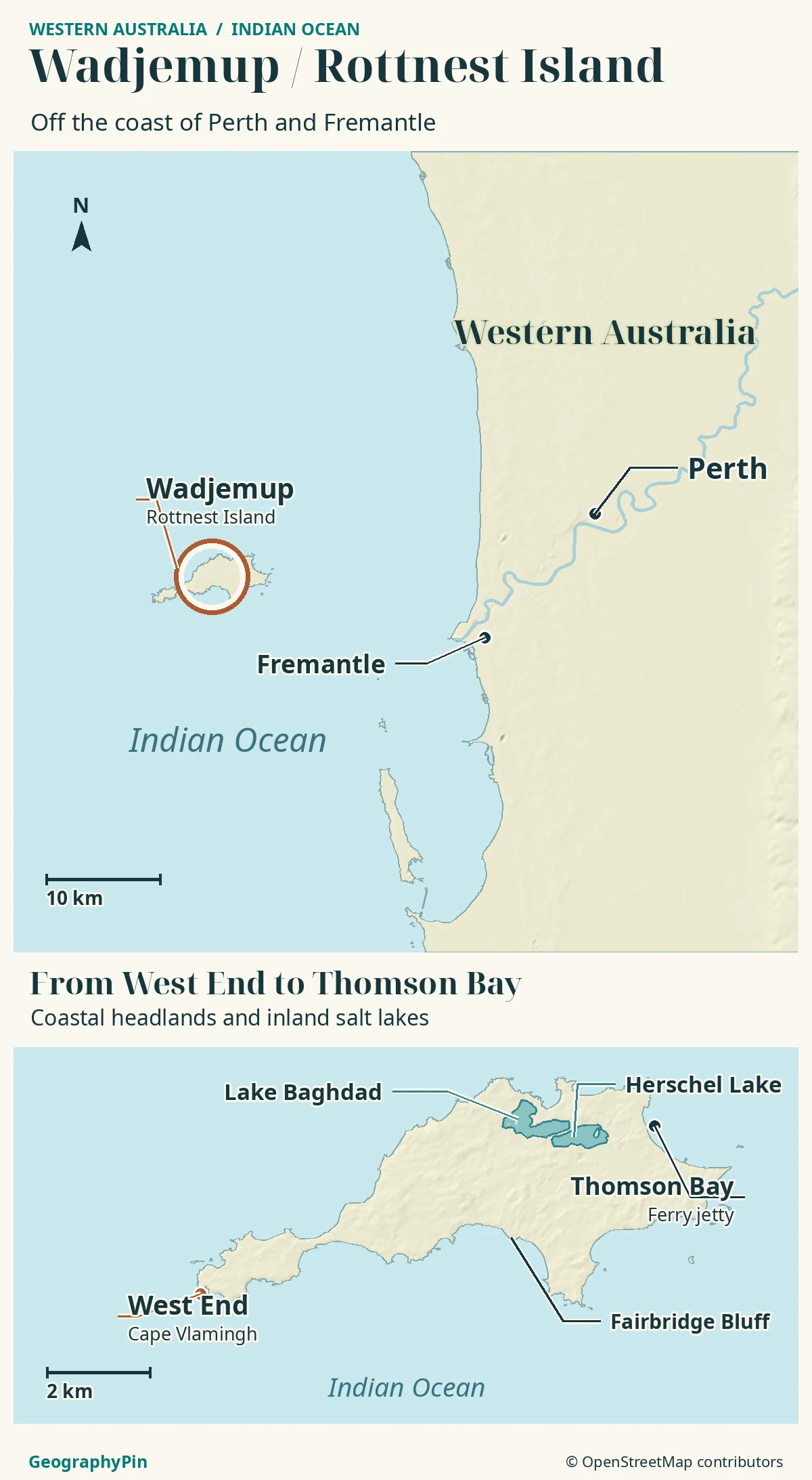
Wadjemup / Rottnest Island lies about 19 kilometers (12 miles) off Fremantle in Western Australia. The mainland-facing settlement and ferry jetty are at Thomson Bay, on the east side. Inland salt lakes and the exposed limestone headlands at West End reflect a long history of changing sea levels.
How to use this article: Use the map to find the ferry-facing coast, then read what the exposed coral tells us, how freshwater and salt lakes coexist, and which map shows marine rules.
Where Wadjemup Sits Off Perth
Wadjemup / Rottnest Island is in the Indian Ocean off southwestern Australia. The island authority places it roughly 19 kilometers (12 miles) offshore from Fremantle, the port at the Swan River mouth. Perth’s city center is inland along that river, so a measurement from central Perth is not the same distance as the offshore gap from Fremantle.
Thomson Bay faces the mainland
The main passenger jetty and settlement face the mainland at the island’s eastern end. The bay arcs between rocky points, with sandy beaches, shallow platforms and structures that interrupt the shore. On the opposite end, West End meets the Indian Ocean directly. The two coasts are on the same small island but face very different conditions.
A Limestone Island Shaped by Changing Seas
Much of Wadjemup is limestone made from sand rich in calcium carbonate. Wind piled the sand into dunes, and over time the sediment hardened. That helps explain why the present island is not simply a coral reef that grew into a ring. Ancient reef material and younger or older layers of dune limestone can tell different stories about the same coast.
Why there are old corals above high tide
At Fairbridge Bluff, the Geological Survey of Western Australia identifies ancient corals about 132,000 years old. They are now above today’s high-tide mark. The survey interprets them as evidence of a higher sea level at the time the corals grew. Later, when more water was held in ice sheets, sea level was lower and the land now called Wadjemup was connected to the mainland.
Why the Lakes Inland Are Salty
Several of the island’s lakes sit in low basins that formerly had connections to the sea. Research describes the basins as the product of repeated limestone deposition and dissolution as sea level changed. After the basins became isolated, evaporation could remove the water while leaving salts behind. Summer drying can make a lake much saltier than the nearby ocean.
Salt lakes are not the island’s whole water supply
Herschel and Lake Baghdad are useful landmarks in the inland lake district. But a mapped surface lake is not the same thing as the groundwater beneath the island. A freshwater lens is a body of relatively fresh groundwater that sits above denser saline water. Research has documented rain-derived fresh groundwater on Wadjemup as well as the very salty lake water visible on the surface.
From the West End Headlands to the Marine Reserve
Narrow Neck connects West End to the rest of Wadjemup. Beyond it, Cape Vlamingh and nearby Cathedral Rocks mark the shift to a more exposed coast. On other sides of the island, rock platforms, reefs and pockets of sand alternate. A rock platform at the base of a cliff is not the same landform as an offshore reef, even where both soften incoming waves.
An island shoreline is not a marine-zone boundary
The Rottnest Island Authority manages the reserve on behalf of Western Australia. The authority’s boating map distinguishes the wider marine reserve from individual sanctuary and other management zones. The geographic locator above does not show those regulatory boundaries. Use the authority’s current marine map for fishing or boating rules, and stay back from unstable limestone ledges.
The Name Wadjemup and the Island’s History
Wadjemup is the name used by the Whadjuk Noongar people, the Traditional Owners. Their connection to this place predates its separation from the mainland. Archaeological material includes evidence that people occupied the land before it became an island.
The same water that now separates a ferry destination from Fremantle was used by colonial authorities to isolate Aboriginal prisoners. The island authority dates its use as an Aboriginal prison from 1838 to 1902, with imprisonment and forced labor continuing in a later phase until 1931. The burial ground and the Quod are part of that history. Present-day tourism and the island’s significance to Aboriginal communities cannot be understood as the same story.
Frequently Asked Questions
Can you drive a car from Fremantle to Wadjemup?
No. There is no bridge or road connection to the mainland. Regular visitors commonly cross by passenger ferry to Thomson Bay. Check the ferry operator for the actual mainland departure point.
Does the shape of the salt lakes on a map stay the same all year?
Not necessarily. Water levels fluctuate, and some smaller basins can dry out seasonally. A mapped outline shows the lake’s location and general extent, not the current waterline.
What Did We Learn Today?
The island’s sheltered east, salty interior and exposed west tell different parts of the same story. Sea levels helped shape limestone, sever the link to the mainland and leave salty inland basins. The modern shoreline is only one moment in that longer history, and it is not a map of marine rules.
Sources & Data Notes
The 19-kilometer figure is the island authority’s approximate offshore distance from Fremantle, not a ferry route length. The Geological Survey dates the Fairbridge Bluff corals, not the whole island, to about 132,000 years ago. Research distinguishes individual lake histories, so no single isolation date is assigned to every basin. References checked November 2026.
- Rottnest Island Authority: island setting and separation from the mainland
- Island authority: geographic names, bays and jetty
- Geological Survey of Western Australia: limestone and dated corals
- Bryan et al. (2016): groundwater, salt lakes and evaporation
- Bischoff (2019): lake sediments and environmental history
- Island authority: named salt lakes and seasonal changes
- Rottnest Island Authority: marine zone map
- Rottnest Island Authority: Aboriginal history of Wadjemup
Map: GeographyPin original atlas using OpenStreetMap coastlines, Thomson Bay jetty, Cape Vlamingh, Fairbridge Bluff, Lake Baghdad and Herschel Lake, retrieved November 19, 2026. © OpenStreetMap contributors, ODbL. Relief from Mapzen/AWS Terrain Tiles and underlying elevation sources. No sailing routes, access guarantees or marine-zone boundaries are depicted.
Photograph: Cape Vlamingh, Chad King (Ninjapacman), April 13, 2015, CC BY-SA 4.0. Resized and converted to WebP.
