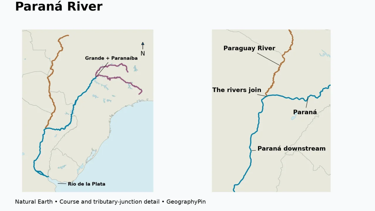
The Paraná River begins where the Grande and Paranaíba meet in Brazil. It follows stretches of Brazil–Paraguay and Paraguay–Argentina border before continuing through Argentina to its delta and the Río de la Plata. The Paraguay River is a tributary; the Uruguay River reaches the same estuary through a separate course.
How to use this article: Trace the course, understand the source confluence, and explore the downstream connections.
1. Where is the Paraná River?
The Paraná is one of the major rivers of south-central South America. Its named mainstem connects Brazil, Paraguay and Argentina, while the larger Río de la Plata basin includes parts of five countries: Argentina, Bolivia, Brazil, Paraguay and Uruguay.
Those two country lists describe different things. The first follows the Paraná channel and its border reaches. The second describes the larger drainage system, including other rivers and the land supplying them. Bolivia and Uruguay belong to the wider basin without the Paraná mainstem crossing their territory.
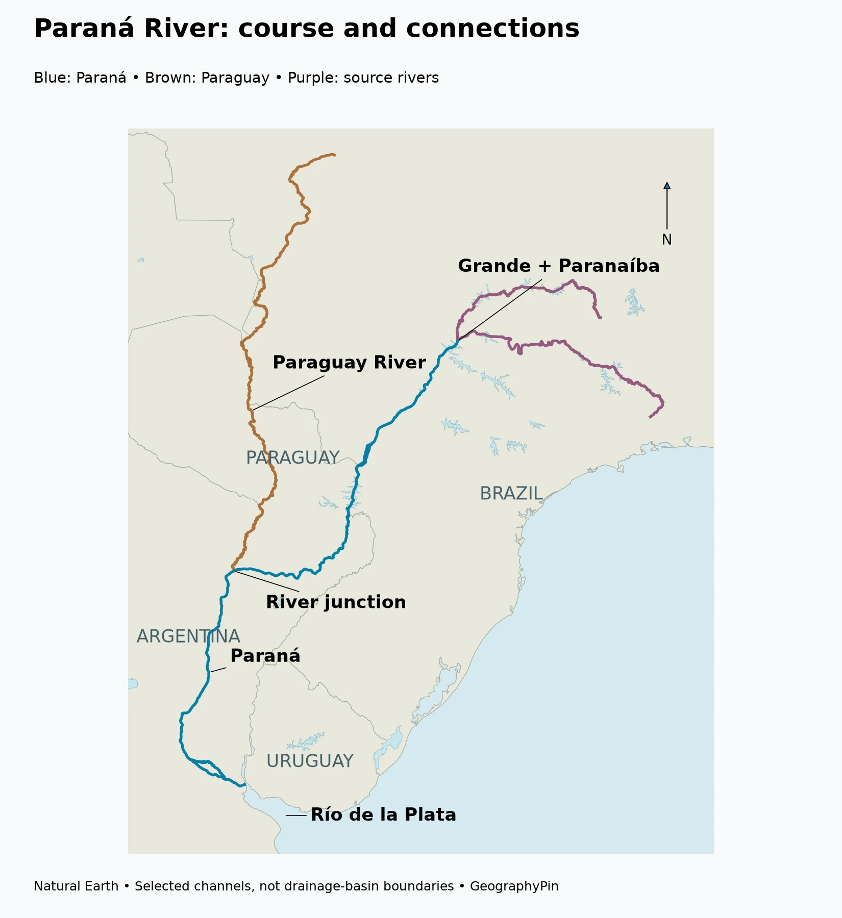
Follow the river through three countries
From its formation in Brazil, the river flows generally southwest through a landscape that includes major reservoirs. Farther downstream, it becomes part of the Brazil–Paraguay boundary. At the Iguaçu, also spelled Iguazú, confluence, the border pairing changes: the Paraná then separates Paraguay from Argentina.
After meeting the Paraguay River, the Paraná continues within Argentina. Its lower course leads south toward the delta and the Río de la Plata. A map showing only national borders can make these transitions difficult to follow, so the river junctions are more useful reference points than a simple list of countries.
| Reach or junction | Countries and connection | What changes here? |
|---|---|---|
| Grande–Paranaíba confluence | Brazil | The named Paraná begins |
| Itaipu reach | Brazil–Paraguay border | A major reservoir occupies part of the river corridor |
| Iguaçu/Iguazú confluence | Brazil, Paraguay and Argentina meet in this region | The Paraná continues along the Paraguay–Argentina boundary |
| Paraguay River confluence | Near the Corrientes–Resistencia area | A major tributary joins; the Paraná continues into Argentina |
| Lower Paraná and delta | Argentina | The river branches across an extensive delta before reaching the Río de la Plata |
| Río de la Plata | Argentina and Uruguay | Paraná and Uruguay waters enter a shared estuarine outlet toward the Atlantic |
Mainstem, tributary and basin
A mainstem is the principal named channel being followed. A tributary feeds it, while a basin is the area contributing water to a chosen outlet. Our guide to river parts and drainage basins explains these relationships in more detail.
The Paraguay River has its own headwaters, tributaries and floodplains, but its water eventually enters the Paraná. The Uruguay River follows a separate route to the Río de la Plata. Calling all three part of the La Plata system is correct; calling all three stretches of the Paraná is not.
2. Where does the Paraná begin, and how long is it?
The Grande and Paranaíba rivers meet in Brazil to form the Paraná. This is the beginning of the named river, not the most distant place from which water can eventually reach its mouth. Each source river has an upstream drainage network of its own.
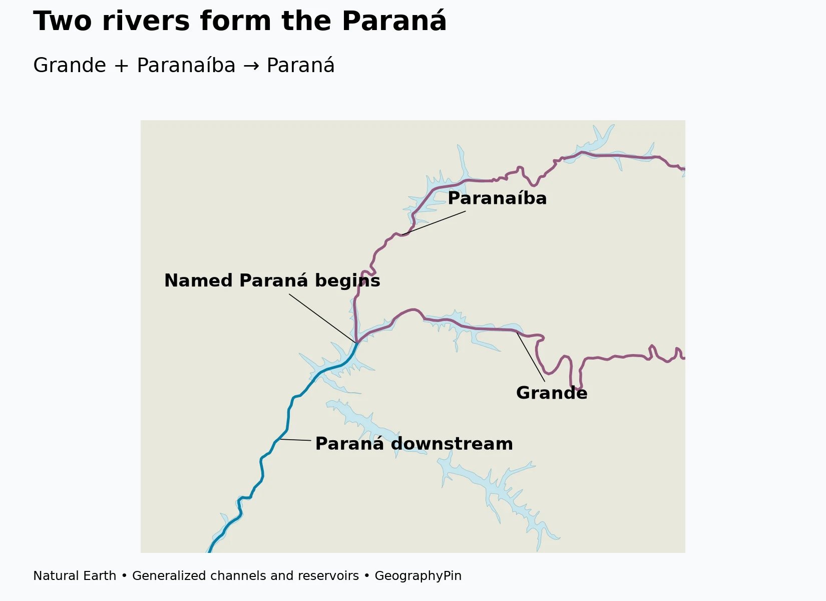
Two source rivers, one named channel
The confluence is a useful place to begin tracing the Paraná because the name changes there. Water arriving through the Grande and Paranaíba continues downstream under the Paraná name. Reservoirs and broad water surfaces around parts of the upper network can make the junction less visually obvious than the neat Y-shaped diagram in a textbook.
That is also why a thin river line and a reservoir shoreline should not be read as competing versions of the same feature. A centerline follows the generalized channel route; a water polygon shows the broader mapped surface. Both can be useful, but they answer different questions.
Compare lengths only when the endpoints match
The intergovernmental CIC Plata gives the Paraná a length of about 1,597 miles (2,570 kilometers) from the Grande–Paranaíba confluence to the Río de la Plata. The same source gives about 2,324 miles (3,740 kilometers) when the Paranaíba is included.
These are not two measurements of exactly the same start-to-finish route. One begins where the Paraná name starts; the other adds a source river. A longer figure should not automatically be substituted into a mainstem table without explaining that change.
For this profile, the confluence-to-estuary figure is the reference length. It is attributed to CIC rather than calculated from the display map, whose curves and small channels are generalized. The important comparison is the definition of the route, not an appearance of precision created by extra digits.
3. Paraná, Paraguay and Uruguay: which river joins which?
The similar names can be confusing, especially because Paraguay and Uruguay are also country names. Following the water downstream resolves the confusion more reliably than memorizing names in isolation.
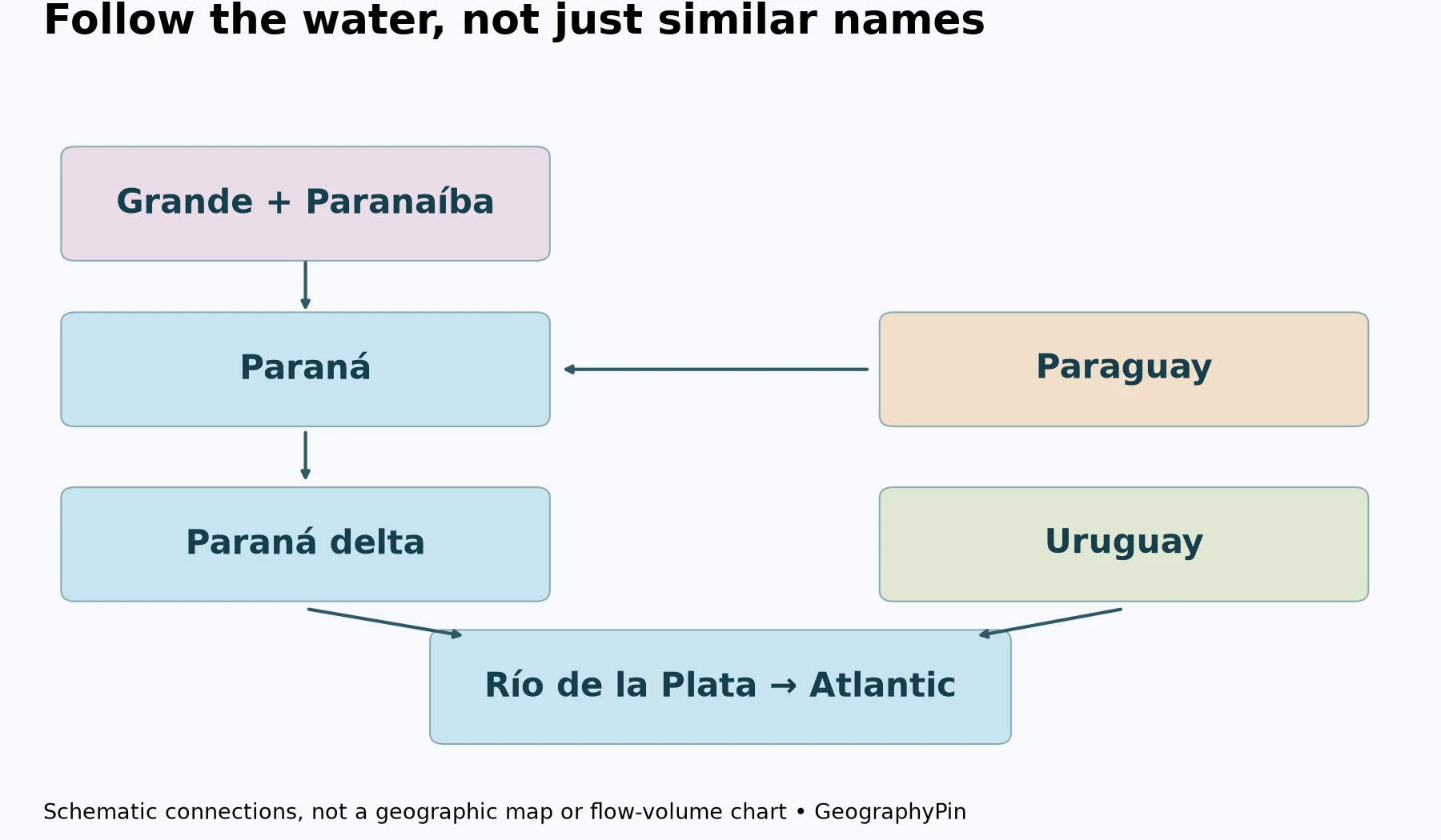
The Paraguay enters the Paraná
The Paraguay River flows south through a broad lowland drainage network before meeting the Paraná near the Corrientes–Resistencia region. From that junction, their combined water continues along the lower Paraná toward Argentina’s delta.
CIC describes much of the Paraguay subbasin as a low-gradient alluvial plain with extensive floodplains. This contrasts with the stepped uplands associated with the upper Paraná. The two branches therefore connect different landscapes, not merely different country labels.
A tributary can be a very large river in its own right. “Tributary” describes its downstream relationship, not a rule that it must be a small stream. The Paraguay is a particularly useful example because its name remains important across a large region before the junction.
The Uruguay reaches the shared estuary separately
The Uruguay River should not be drawn as an upstream branch feeding the Paraná somewhere near Paraguay. It runs through a different part of the La Plata system and reaches the estuarine head alongside the Paraná’s outlet network.
The schematic distinguishes these relationships: Paraguay → Paraná, but Uruguay → Río de la Plata. This is a connectivity diagram, so the boxes are not positioned to represent geographic distances, channel widths or flow volumes.
The Río de la Plata is the shared estuarine receiving water. Although its Spanish name includes “Río,” it is not simply another narrow inland river reach. Treating it as an estuary helps explain why the Paraná’s delta, the Uruguay’s mouth and the coasts of Argentina and Uruguay appear together at this end of the system.
4. What the delta adds to the map
In its lower reaches, the Paraná contains islands, bars and branching channels. The delta develops this pattern into a broad landscape of islands and waterways leading toward the Río de la Plata.
A delta is more than a single mouth
Argentina’s Prefectura Naval describes the delta from the Diamante area downstream and distinguishes upper, middle and lower delta sectors. The lower sector is still forming at the estuarine end. This is more informative than marking one coastal dot as “the mouth” and ignoring the branches around it.
Sediment carried by the river helps build and reshape the delta. Water moving around islands can erode one bank and deposit material elsewhere, so the geography includes changing channels and surfaces rather than a permanently fixed outline of every island.
The river and estuary are related but distinct: the delta is the sediment-built landform and channel network; the Río de la Plata is the receiving estuary. A delta can grow into an estuarine setting, so the two terms do not have to describe mutually exclusive places.
River flow is not the only influence downstream
CIC notes that Paraná and Uruguay floods can interact with elevated Río de la Plata water levels associated with southeasterly winds. This means lower-delta water levels cannot be understood solely by asking how much rain fell beside one island.
That regional connection is a geographic explanation, not a forecast for any particular property or boat route. The maps here do not show current flooding, water depth or navigable channels. Those require up-to-date local observations and official notices.
5. Reservoirs, borders and names: three useful checks
Itaipu is on the Paraná, not the Paraguay River. Its location on the Brazil–Paraguay border can make the river and country names easy to mix up. The reservoir is part of the Paraná corridor; the Paraguay tributary joins much farther downstream.
Iguazú Falls are on the Iguazú/Iguaçu River, not the Paraná mainstem. The tributary meets the Paraná below the falls. Sharing a drainage system does not mean that every famous feature lies on the principal named river.
Paraná can mean more than the river. The name also belongs to a Brazilian state and an Argentine city. In this article, “Paraná River” refers to the watercourse; the country and tributary descriptions are not statements that the entire basin lies in the Brazilian state of Paraná.
These distinctions make the river easier to place in the wider geography of South America. The upper channel begins at a Brazilian confluence, border reaches connect three countries, the Paraguay adds a large tributary system, and the delta delivers the combined flow to an estuary shared with the Uruguay River.
Frequently Asked Questions
Which countries does the Paraná River flow through?
Its named course is associated with Brazil, Paraguay and Argentina, including international border reaches. The larger La Plata basin also includes Bolivia and Uruguay.
Where does the Paraná River begin?
At the confluence of the Grande and Paranaíba rivers in Brazil. A length that includes one of those source rivers uses a different starting point.
Are Paraná and Paraguay the same river?
No. The Paraguay is a major tributary that joins the Paraná near the Corrientes–Resistencia region. The combined flow then continues along the Paraná.
Does the Paraná empty directly into the Atlantic?
It reaches the Río de la Plata through its delta. The Río de la Plata is the estuarine connection to the Atlantic, so naming that intermediate receiving water is more precise.
Are Iguazú Falls on the Paraná River?
No. The falls are on the Iguazú/Iguaçu River, which later joins the Paraná.
What Did We Learn Today?
The Paraná begins at the Grande–Paranaíba confluence, follows border reaches linking Brazil, Paraguay and Argentina, and continues to a delta opening into the Río de la Plata. The Paraguay is a tributary, while the Uruguay reaches the shared estuary separately. Keeping named mainstem, source-river length, tributary network and five-country basin distinct makes the map much easier to understand.
Sources & Data Notes
- CIC Plata: Subcuencas: Grande–Paranaíba origin; explicitly scoped 2,570-kilometer mainstem and 3,740-kilometer route including Paranaíba; Paraguay connection and delta processes.
- CIC Plata: basin observatory: five-country basin context.
- Itaipu Binacional: Rio Paraná: border sequence, reservoir and source-river context. Its differing total-length figures and rankings are not used.
- Prefectura Naval Argentina: river and delta campaign areas: Río de la Plata receiving connection, delta sectors and sediment-related channel change. No historical discharge figure is treated as a current observation.
- UNESCO: Iguaçu National Park: falls on the Iguaçu tributary, upstream of its Paraná confluence.
- Natural Earth public-domain data: country, channel and reservoir geometry for original GeographyPin maps.
Cartographic method: Actual Natural Earth 1:10m geometry uses a Lambert azimuthal equal-area projection centered at 26°S, 55°W, with equal aspect. The source dataset groups some differently named channels inside multipart features: the Paraguay segment is separated from a feature labeled Paraná River, and the Paranaíba continuation is separated at the Grande junction. These are documented selections of existing vertices, not newly invented river lines. Maps show selected channels and generalized reservoir surfaces, not basin outlines, current inundation, depths or a complete delta network. The separate connection diagram is deliberately schematic.
Length convention: CIC’s 2,570 kilometers converts to approximately 1,597 miles; 3,740 kilometers including the Paranaíba converts to approximately 2,324 miles. These figures describe different upstream endpoints and are not calculated from the map geometry. No global length ranking or current dam-operation claim is made.