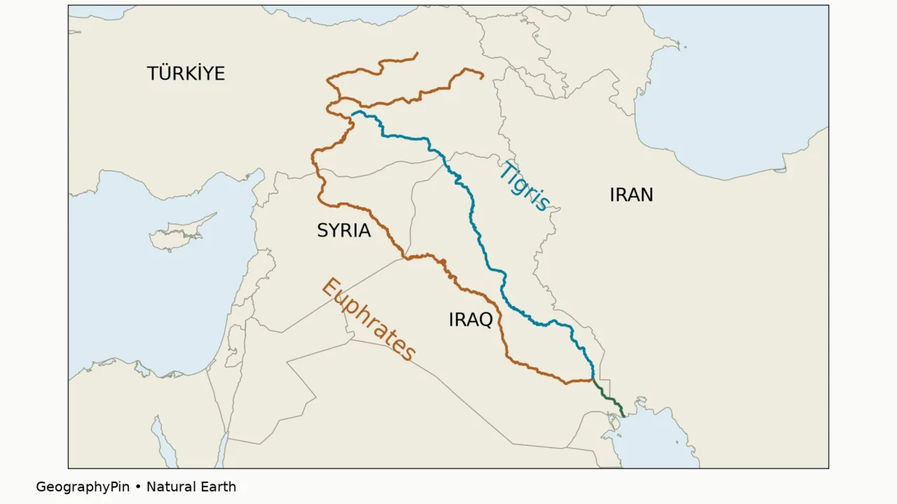
Two rivers dominate the map of Mesopotamia, but their routes are often blurred together. The Tigris passes Baghdad; the Euphrates takes a longer western course through Syria. Their meeting point in southern Iraq creates another named waterway, the Shatt al-Arab.
The Tigris and Euphrates rise in eastern Türkiye and flow toward southern Iraq. The Euphrates crosses Syria; the Tigris follows a more easterly course past Mosul and Baghdad. They join near Qurnah to form the Shatt al-Arab, which continues past Basra to the Persian Gulf.
1. Where are the Tigris and Euphrates?
Two routes from the northern highlands
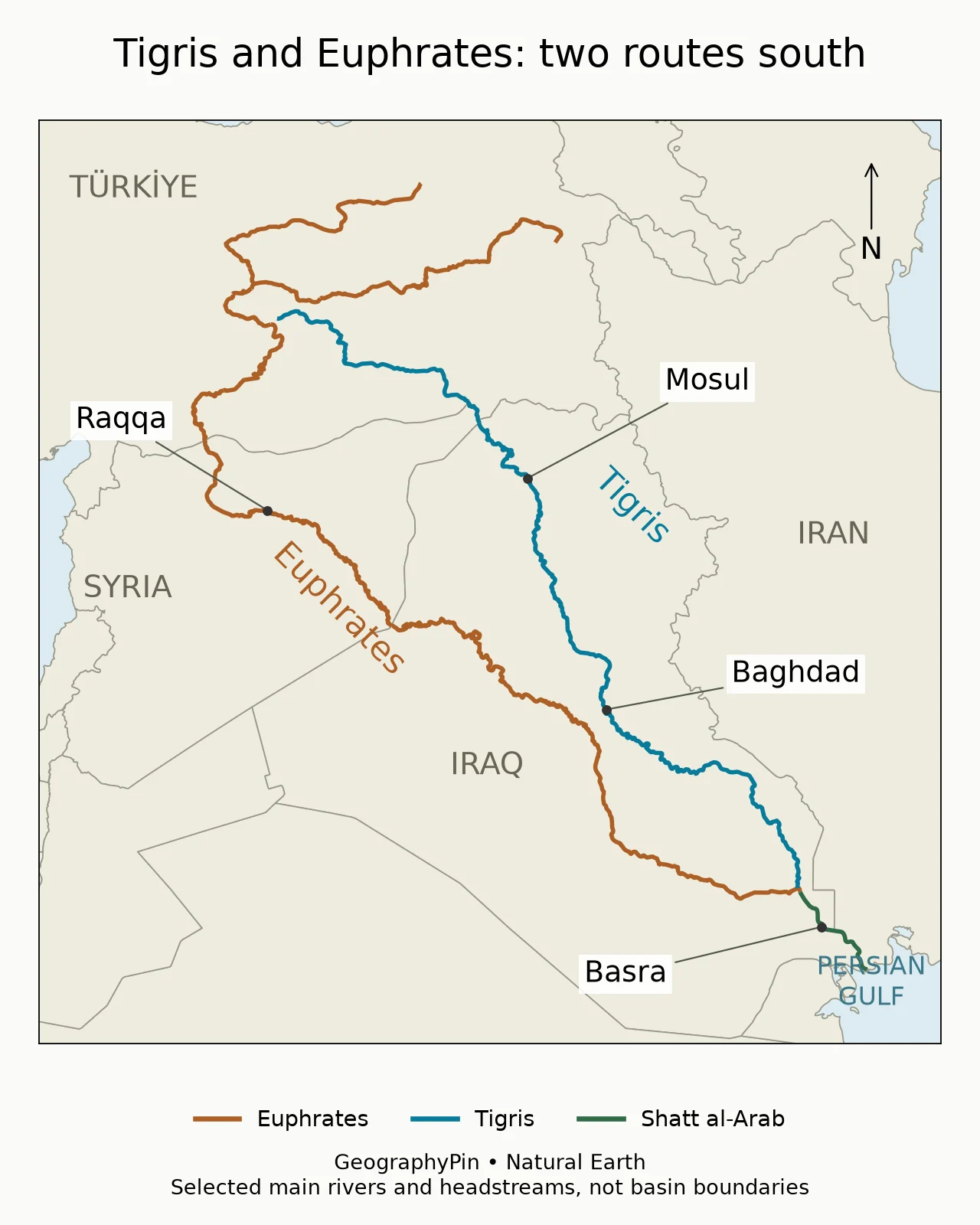
The Tigris and Euphrates begin in the highlands of eastern Türkiye and run generally southeast toward southern Iraq. They belong to a connected river system, but they are not two names for the same channel. The Euphrates takes the more westerly route through Syria; the Tigris takes the easterly route through northern and central Iraq.
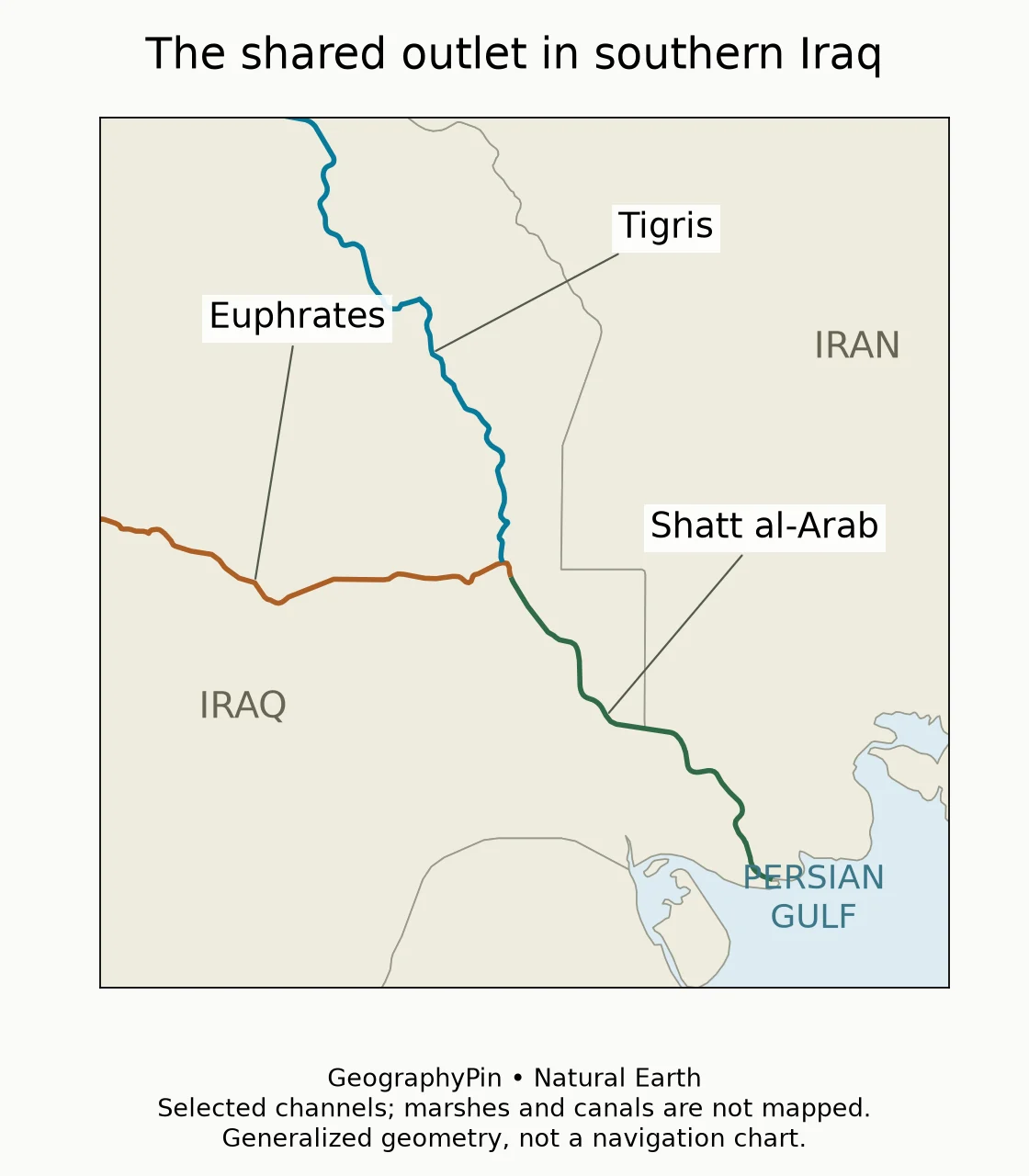
On the map, follow the brown Euphrates line through Raqqa in Syria, then across western Iraq. Follow the blue Tigris line past Mosul and Baghdad. Near the bottom of the map, the two lines meet and continue as the green Shatt al-Arab toward the Persian Gulf. Basra lies beside that shared lower waterway, not on a separate Euphrates outlet.
The upstream landscape is mountainous, while the lower rivers cross the low alluvial plain of Iraq. This transition is important: water originating in wetter uplands can support farming and wetlands far downstream in a much drier setting. The climate immediately beside a river does not describe the climate of its entire catchment.
The main differences at a glance
| Feature | Tigris | Euphrates |
|---|---|---|
| Position | Eastern river | Western river |
| Main-course countries | Türkiye, a short Syrian border reach, Iraq | Türkiye, Syria, Iraq |
| Cities shown | Mosul and Baghdad | Raqqa |
| Selected tributaries or headstreams | Greater Zab, Lesser Zab and Diyala | Karasu and Murat headstreams; Sajur, Balikh and Khabour tributaries |
| Downstream connection | Join near Qurnah to form the Shatt al-Arab | |
Reading the two rivers together explains their shared outlet. Reading them separately explains why a country or city can be associated with one channel rather than the other. Baghdad, for example, is a Tigris city, not a city on the Euphrates.
2. Headwaters, tributaries and river lengths
The Euphrates has two important headstreams
The Karasu, sometimes called the Western Euphrates, and the Murat, or Eastern Euphrates, unite near Keban in Türkiye. Downstream, the Euphrates crosses into Syria before reaching Iraq. Its Syrian tributaries include the Sajur, Balikh and Khabour. These names describe different branches of a drainage network, not alternative names for every part of the main river.
The Tigris also begins in eastern Türkiye, then turns toward Iraq after a short reach along the Turkish–Syrian frontier. Important tributaries approach it from the east and northeast. The Greater Zab connects it to uplands in Türkiye and Iraq; the Lesser Zab and Diyala connect it to catchments extending into Iran.
This eastern tributary network is the reason Iran belongs in a discussion of the Tigris basin even though the main Tigris does not cross Iran. Conversely, a map showing only the principal channel leaves out much of the land supplying its water. The locator above deliberately emphasizes the two main routes rather than attempting to show every tributary.
Which river is longer?
The Euphrates is longer. The UN-ESCWA and BGR regional inventory gives a reference length of about 1,730 miles (2,786 kilometers) for the Euphrates, compared with about 1,120 miles (1,800 kilometers) for the Tigris. The Euphrates measurement follows the Karasu headwater to the confluence with the Tigris.
That endpoint matters. The Shatt al-Arab continues beyond the junction, but adding it to one river’s length while excluding it from the other would not be a like-for-like comparison. Likewise, choosing a different headstream or a more detailed channel line can change a published length. These figures are the inventory’s reference values, not new measurements made from our map.
3. Where the rivers meet: the Shatt al-Arab
From Qurnah past Basra to the gulf
The Tigris and Euphrates join near Qurnah in southern Iraq. Below their confluence, the waterway is called the Shatt al-Arab. It passes Basra and continues to the Persian Gulf; its lower reach forms part of the boundary between Iraq and Iran. The Persian name is Arvand Rud.
This is why a simple statement that each river “flows into the Persian Gulf” needs a little explanation. Both belong to a system draining to the gulf, but their named main channels first unite into a third named waterway. A confluence and a river mouth are different features.
The lower system also receives water from Iran. The Karun joins the Shatt al-Arab, while the Karkheh connects to the marsh system. These rivers should not be mislabeled as the Greater Zab, Lesser Zab or Diyala, which belong to the Tigris tributary network farther upstream.
At this scale, a few colored lines cannot represent every distributary, canal or wetland connection across southern Iraq. They do, however, establish the essential sequence: two main rivers, their junction, the Shatt al-Arab, and the gulf. That sequence is more useful than treating the entire lowland water network as one undifferentiated delta.
4. Mesopotamia and the southern marshes
A river plain, not a fixed historical coastline
The Tigris and Euphrates are central to the geography of Mesopotamia, the historical region associated with the lands between and around the two rivers. This historical name is not a modern international border. Nor should a present-day river map be read as an exact reconstruction of waterways beside ancient settlements.
Across the lower alluvial plain, sediment deposition and changing channels have reshaped the relationship between land and water over long periods. UNESCO’s account of the Ahwar of Southern Iraq connects the archaeological sites of Uruk, Ur and Tell Eridu with the marshy delta environment in which they developed. Their geography cannot be understood simply by projecting today’s gulf shoreline backward in time.
The UNESCO property contains seven components: three archaeological sites and four wetland areas. The designation recognizes both cultural heritage and the ecological importance of the marshes. It is not a boundary around the entire Tigris–Euphrates basin.
The major southern marsh settings include the Central Marshes, Hammar and Huwaizah. Their water connections help explain why the river system is more than two channels ending at a single point. A wetland can receive and redistribute river water across a broad lowland landscape; its visible water extent can change without the main river changing its name.
5. River countries are not the same as basin countries
Follow the water, not just the main channel
A drainage basin includes the land feeding a river through tributaries and runoff. The 2013 regional inventory identifies the Tigris basin across Türkiye, Syria, Iraq and Iran. For the Euphrates basin, it includes Türkiye, Syria and Iraq together with small areas in Jordan and Saudi Arabia.
Those lists do not mean the main Euphrates flows through Jordan or Saudi Arabia, or that the main Tigris crosses Iran. They describe catchment geography. The distinction is especially important when a country list accompanies a map: ask whether it refers to the channel, the drainage area or an administrative agreement.
The rivers also cross national jurisdictions while remaining physically connected. Rainfall and snowmelt in the headwaters, reservoir operations, irrigation withdrawals and tributary inflows can affect conditions farther downstream. An upstream dam can change timing as well as quantity; a border does not interrupt the hydrological connection.
This article uses the regional inventory for enduring route and basin geography, not as a live water-availability report. Its historical discharge and water-use tables should not be treated as measurements of present conditions. For a general explanation of channels, tributaries and outlets, see our guide to what a river is and how its parts connect.
Frequently Asked Questions
Is Baghdad on the Tigris or the Euphrates?
Baghdad is on the Tigris. The Euphrates runs to its west through Iraq.
Do the Tigris and Euphrates have separate mouths?
Their main channels join near Qurnah. Below the junction, the Shatt al-Arab continues toward the Persian Gulf; the southern lowland also contains a more complex network of wetlands and channels.
Does the Tigris flow through Iran?
The main Tigris does not cross Iran, but tributaries draining Iranian territory feed it. Iran is therefore part of the wider Tigris basin.
Is Mesopotamia a country?
No. Mesopotamia is a historical geographic region associated with the Tigris and Euphrates, not a present-day sovereign country.
What Did We Learn Today?
The Euphrates is the longer, western river; the Tigris is the eastern river passing Mosul and Baghdad. They meet near Qurnah and continue as the Shatt al-Arab. Their tributaries and marshes connect a wider landscape than the main channels alone, so basin-country lists and historical Mesopotamia should not be confused with a simple river route.
Sources & Data Notes
Route, tributary and basin descriptions use the UN-ESCWA/BGR regional inventory. Its 2013 publication date applies to the source, not to a claim of current flow conditions. Lengths are rounded in miles with the inventory’s kilometer values retained. GeographyPin maps use Natural Earth 1:10m country, river and populated-place data. Selected river lines and headstreams are generalized; basin boundaries, seasonal water coverage, canals and ancient coastlines are not shown. They are geographic locators, not navigation or border-survey charts.
- UN-ESCWA/BGR: Euphrates River Basin (2013), headstreams, route, basin and length definition
- UN-ESCWA/BGR: Tigris River Basin (2013), route, tributaries and reference length
- UN-ESCWA/BGR: Shatt al-Arab, Karkheh and Karun Rivers (2013)
- UNESCO: The Ahwar of Southern Iraq
- Natural Earth: public-domain map data