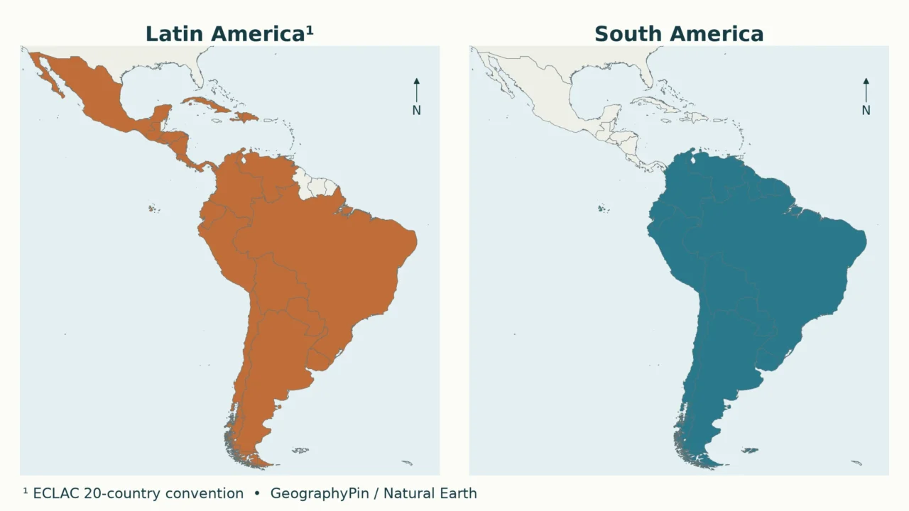
Mexico and Brazil can both be described as Latin American, but only Brazil is in South America. The apparent contradiction disappears once a cultural region is separated from a continent, and once the definition behind a colored map is made explicit.
Latin America and South America are not the same: Latin America is a cultural-historical regional term, while South America is a continent. They overlap, but Latin America also reaches into Mexico, Central America and the Caribbean. Guyana and Suriname are South American even when a particular Latin America definition excludes them.
How to use this article: Check the map convention, locate Mexico and Central America, or untangle the Guianas.
1. Read the two maps with their definitions
Which Latin America does the map show?
There is no single cultural boundary that every atlas, institution and individual must use. For a reproducible comparison, the orange map uses the 20-country Latin America grouping in ECLAC’s 2023 Statistical Yearbook. ECLAC is the United Nations Economic Commission for Latin America and the Caribbean. This is a named statistical convention, not a universal verdict on identity.
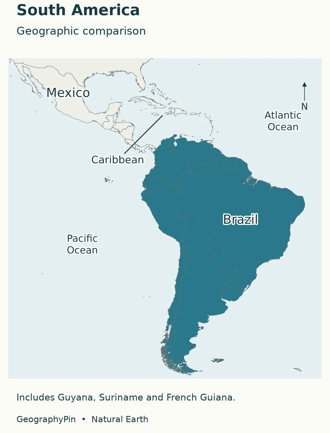
The blue map shows South America geographically, including Guyana, Suriname and French Guiana. The maps use the same extent, orientation and projection so that their different shading reflects a different classification, not a change of viewpoint. Gray means outside the particular highlighted group, not culturally unconnected.
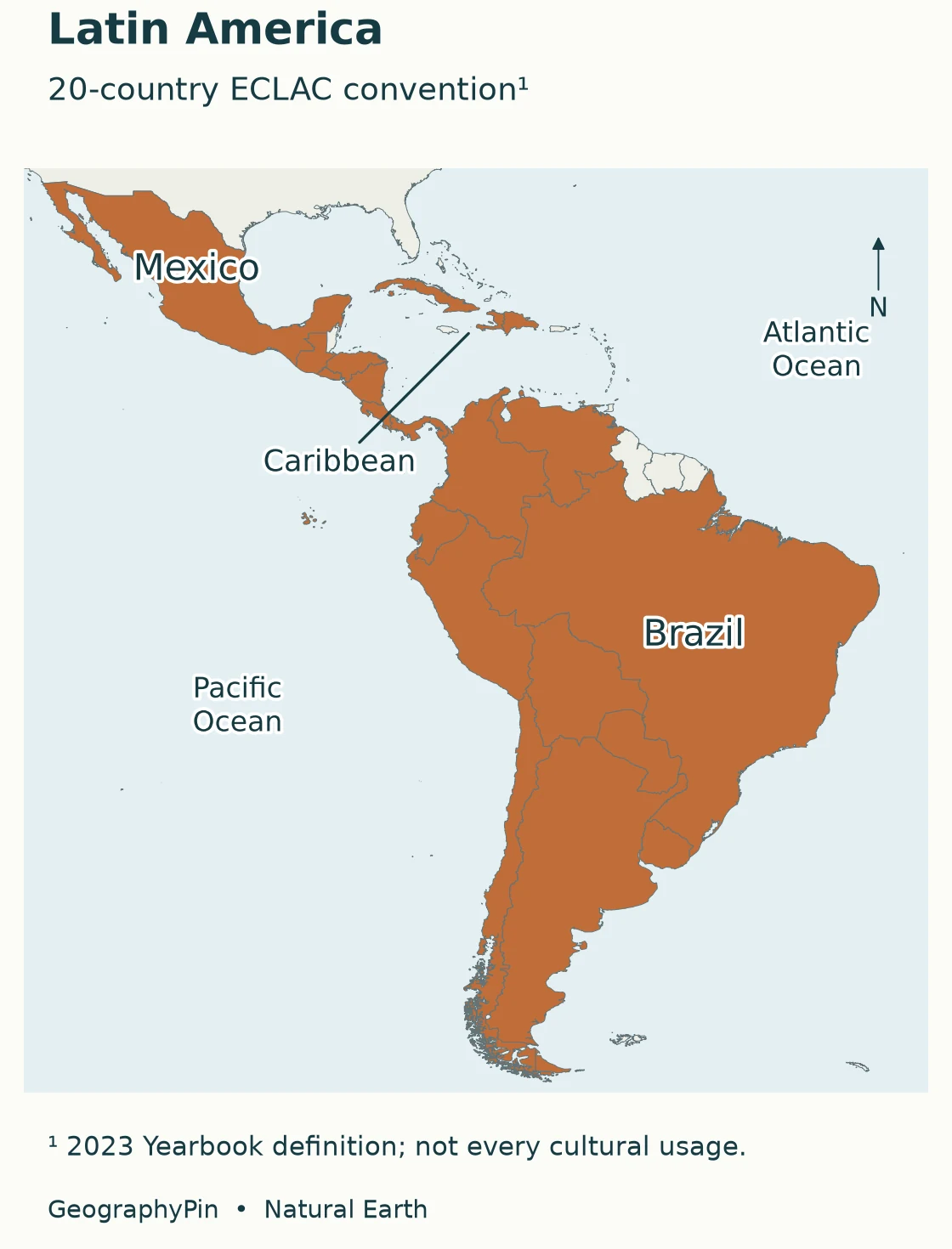
Ordinary cultural usage often emphasizes societies shaped by Spanish and Portuguese colonial histories and also includes Haiti; some definitions include French-speaking territories and Puerto Rico. The Columbia Electronic Encyclopedia records several such usages. Consequently, the orange map should be read as “the ECLAC list used here,” not “the only correct cultural map.”
Neither color maps the language of every resident. Indigenous languages, creoles, immigrant languages and multilingual communities exist across these country outlines. A country-level category is useful for comparison, but it cannot describe every person living within it.
2. Compare the same places under both definitions
| Question | Latin America | South America |
|---|---|---|
| What kind of grouping? | Cultural-historical term; institutions also define statistical lists. | A continent in the seven-continent model. |
| What determines inclusion? | The author’s or institution’s stated convention. | Continental location, not official language. |
| Does it include Mexico? | Yes in the ECLAC grouping used here. | No. Mexico is in North America. |
| Does it include Brazil? | Yes. Portuguese is no barrier to inclusion. | Yes. |
| Does it include Guyana and Suriname? | Not in this ECLAC 20-country list; broader usages can differ. | Yes. |
| Is it a sovereign-country count? | Only if the chosen list is restricted that way. | No. Continental land also includes non-sovereign areas. |
Under the chosen 20-country convention, the overlap is easy to check: 10 countries appear in both groups, and 10 Latin American countries are outside South America. That arithmetic belongs to this comparison, not to all possible definitions of Latin America.
| Location | Countries in the chosen Latin America group |
|---|---|
| South America: 10 | Argentina, Bolivia, Brazil, Chile, Colombia, Ecuador, Paraguay, Peru, Uruguay and Venezuela. |
| Elsewhere: 10 | Mexico; Guatemala, El Salvador, Honduras, Nicaragua, Costa Rica and Panama; Cuba, Haiti and the Dominican Republic. |
South America’s sovereign-state list adds Guyana and Suriname to the first row, producing the familiar total of 12. French Guiana is on the continent but is part of France, so it is not a thirteenth sovereign country. For the separate lookup task, see the 12 South American countries and their capitals.
3. Mexico and the Caribbean are not South America
Mexico and Central America
Mexico is North American geographically and Latin American under the convention used here. There is no contradiction: “North American” and “Latin American” answer different questions. One identifies continental position; the other identifies a broader cultural or institutional grouping.
The same logic applies to the six Central American countries highlighted in orange. They are not in South America simply because Spanish is widely used or because their histories connect them to countries farther south. In the familiar seven-country definition, Central America runs from Belize and Guatemala through Panama; the Central America countries map shows this isthmus separately.
A further terminology trap is that UN M49 groups Mexico within its statistical “Central America.” This does not move Mexico into South America, and it does not mean every geographic use of Central America includes Mexico. Always distinguish the seven-country geographic convention from the statistical grouping when comparing tables.
Caribbean location does not decide Latin American inclusion
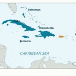
Cuba, Haiti and the Dominican Republic are Caribbean countries included in the chosen Latin America list. None is South American. Jamaica is also Caribbean, but is outside that 20-country list. Caribbean location alone therefore cannot determine inclusion in Latin America.
Haiti also exposes a weakness in the shortcut “Latin America means Spanish-speaking America.” Article 5 of Haiti’s constitution identifies Haitian Creole and French as official languages. Brazil supplies another obvious counterexample through Portuguese. A label rooted partly in colonial languages is not the same as an exclusive list of Spanish-speaking countries.
Puerto Rico illustrates why a country-only list is narrower than a cultural region. It is not among the 20 states on the orange map, but broader cultural descriptions of Latin America can include it. Do not infer cultural exclusion merely from its absence in an institutional list.
4. Belize and the Guianas reveal the limits of regional labels
Belize: Central American and multilingual
Belize is geographically Central American and is not South American. It is outside the selected ECLAC Latin America list. English is its official language, but treating Belize as simply “not Spanish-speaking” would obscure its multilingual reality: its diplomatic information also identifies Spanish, Kriol, Garifuna and Maya languages.
A shaded country map cannot tell you which language a particular Belizean speaks or how that person identifies. It can only tell you how the mapper has classified the country. That distinction matters especially at the edges of cultural regions, where a crisp national border can suggest a cultural separation that is much less tidy.
Guyana, Suriname and French Guiana
Guyana and Suriname sit on South America’s northern mainland coast. Their continental location is unaffected by English being Guyana’s official language or Dutch being Suriname’s. They are excluded from the ECLAC 20-country list used here, but included in the wider UN statistical region called Latin America and the Caribbean.
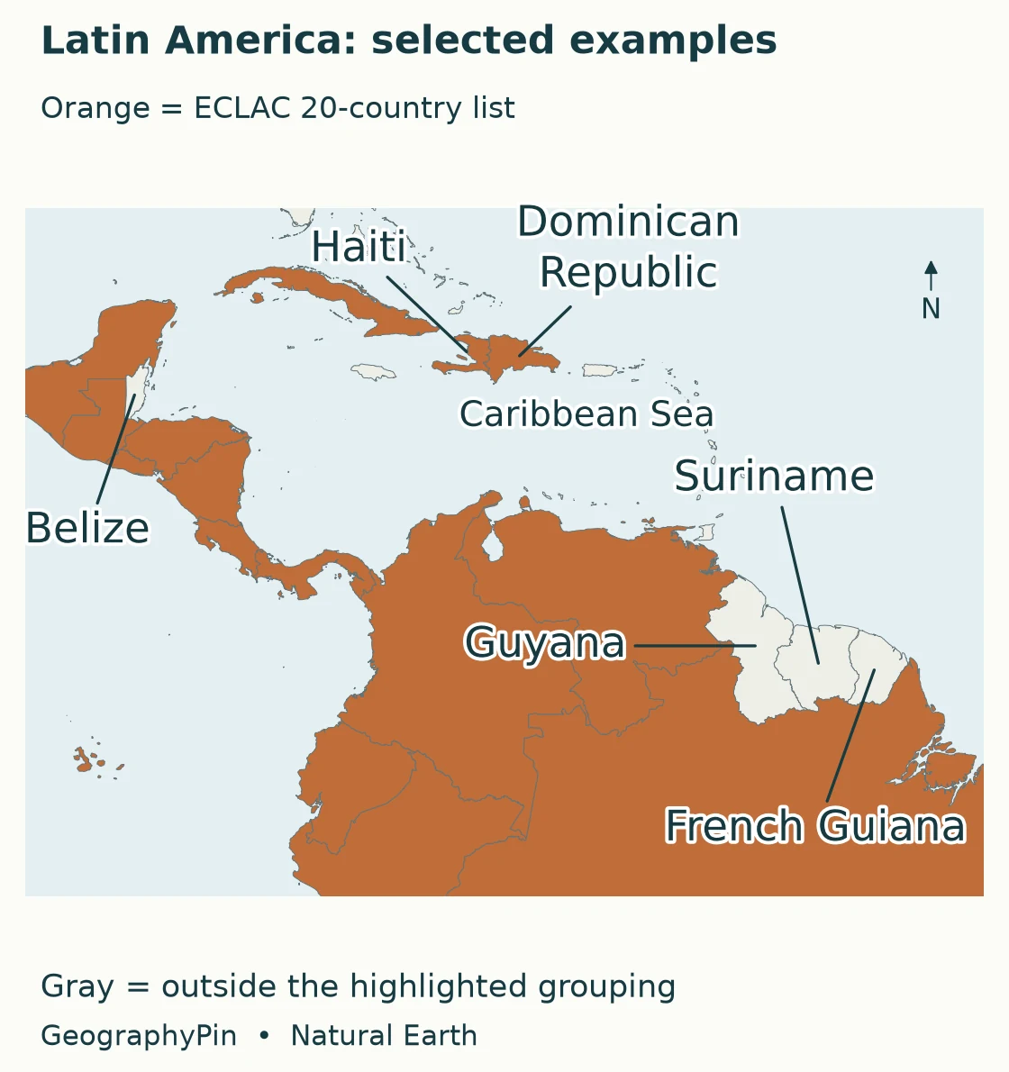
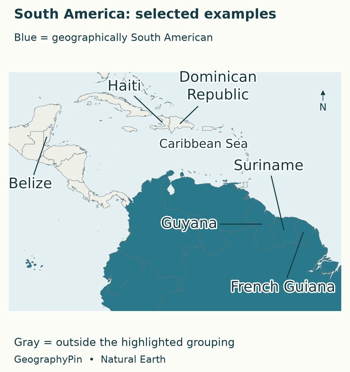
French Guiana is different again. It is geographically South American and politically part of France, with French as its official language. It is not on the chosen 20-country list, which makes it a particularly useful reminder that this institutional convention is not simply “every territory with a Romance official language.” Broader descriptions may include French Guiana in Latin America.
The practical reading rule is to keep three questions separate: Where is the place? What is its political status? Which regional convention is being used? “South American,” “part of France” and “included or excluded from this Latin America list” can all be true statements about different aspects of the same territory.
5. Latin America and the Caribbean is a different statistical label
The United Nations M49 framework places the Caribbean, Central America and South America within Latin America and the Caribbean. This larger statistical grouping includes Belize, Guyana, Suriname and Jamaica. It should not be silently substituted for a narrower cultural meaning of Latin America.
M49 also distinguishes “Northern America” from the broader North American continent. A regional statistical table is not necessarily using the same continent vocabulary as a school atlas. The North American country-and-capital list uses the broader continental frame, including Central America and Caribbean states.
The most reliable way to compare two maps or country counts is to read their legends and coverage notes before comparing their totals. Check whether territories are included, whether a country is grouped by location or by institutional convention, and whether “Latin America” is being used as shorthand for “Latin America and the Caribbean.” Different answers need not indicate a geographic error if the definitions are genuinely different and clearly disclosed.
Frequently Asked Questions
Does French-speaking Canada belong to Latin America?
Not under the conventions used here. The Columbia Electronic Encyclopedia explicitly excludes Canada from its definition despite the presence of French. Latin America is a historical-regional concept, not a mechanical grouping of every place where a language derived from Latin is spoken.
Does “Latin” mean people there speak Latin?
No. The term refers partly to the historical influence of languages derived from Latin, especially Spanish and Portuguese and, in broader usages, French. It does not describe Latin as an everyday regional language.
What Did We Learn Today?
The useful distinction is not simply north versus south. South America describes continental location, while Latin America requires a cultural or institutional definition. Mexico shows why Latin America extends beyond South America; Guyana and Suriname show why the continent extends beyond a narrower Latin America list. French Guiana adds a third dimension: geography and political status are not interchangeable.
Sources & Data Notes
The orange maps apply the explicit 20-country Latin America list in ECLAC’s 2023 Yearbook, not a claim that all cultural definitions agree. Blue shading is geographic. Original GeographyPin maps use public-domain Natural Earth 1:10 million country polygons, identical geographic frames and generalized outlines. Country colors are not language-distribution data, and the maps neither resolve territorial disputes nor show every small island at this scale.
- ECLAC, Statistical Yearbook 2023: explanatory notes and regional coverage
- UN Statistics Division: M49 geographic regions and classification caveats
- Columbia Electronic Encyclopedia via Infoplease: Latin America and variable usage
- Embassy of Belize in the United States: language and country background
- Embassy of Guyana in Qatar: country and language information
- Government of Suriname: country and language overview
- Haiti constitution, Article 5, via Constitute: Creole and French
- Atout France: French Guiana, location, status and languages
- Natural Earth: public-domain cartographic data and reuse terms