A Rocky Mountains map needs to show more than a stripe through Colorado. The system crosses an international border, includes several distinct mountain groups, and contains basins that break up the high terrain. Its boundaries also differ from those of the Continental Divide and the wider North American Cordillera.
The Rocky Mountains extend from northern British Columbia to New Mexico through western North America. They occupy parts of British Columbia, Alberta and several U.S. states. The broader U.S. Rocky Mountain System includes Northern, Middle and Southern mountain provinces plus the Wyoming Basin; the Rockies are only part of the North American Cordillera.
How to use this article: Start with the map layers, find states and provinces, or distinguish the Rockies from the divide.
1. Rocky Mountains map: read the system, not one ridge
What the colors and relief show
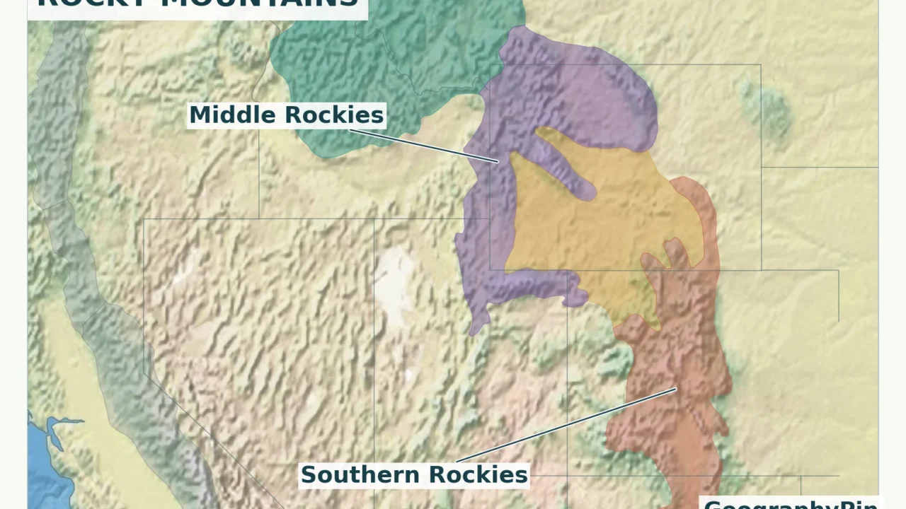
The Rocky Mountains are a chain of mountain ranges and intervening basins on the eastern side of western North America’s much broader mountainous belt. Their overall direction is northwest–southeast, but individual ranges do not all follow that alignment. The map combines terrain shading with named physiographic regions so that a colored area does not have to stand in for the shape of the land.

Read the relief first, the colored regions second, and the state and provincial boundaries third. Relief reveals the roughness of the terrain. The region colors explain a classification. Political borders tell you which jurisdiction contains a location. None of those layers can replace the other two.
A physiographic province is an area grouped by its landforms and geological setting, not a province like Alberta. In the United States, the map uses the USGS/Fenneman framework also used by the National Park Service. Canada uses Natural Resources Canada’s separate physiographic framework. The two are shown together for orientation, not presented as one internationally standardized classification.
The map’s Wyoming Basin belongs to the broader Rocky Mountain System even though much of it is basin country rather than a continuous high range. On the Canadian side, the Rocky Mountain Foothills are distinguished from the Rocky Mountains proper. The outlines are generalized regional boundaries, not a surveyed line separating every mountain from every plain.
For a wider view of neighboring landforms, the physical map of the USA shows where the Rockies sit relative to the Pacific ranges, interior plains and Appalachians.
2. Where the Rockies begin and end
Northern end: the Liard River region
The British Columbia Geographical Names record describes the Rocky Mountains as extending from New Mexico to the Liard River in northern British Columbia. That named-range convention is used here, rather than a broader grouping that extends into Arctic mountain ranges.
The Rockies form part of the Alberta–British Columbia boundary, but farther north they continue within British Columbia. Alberta’s northern boundary is therefore not the northern endpoint of the range. Nor should the Canadian Rockies be reduced to the popular Banff–Jasper corridor: that corridor occupies only part of their extent.
Southern end: New Mexico, not Colorado
The system continues south of Colorado into New Mexico. Around the Sangre de Cristo Mountains and the upper Pecos Valley, the Southern Rockies meet adjoining landscapes of the Great Plains and Basin and Range. Pecos National Historical Park’s geological account describes this southern-end transition.
A mountain system does not end like a highway at one signposted point. Different ranges, foothills and geological structures taper out in different places. New Mexico is the defensible regional answer; marking one arbitrary town as the exact end of all Rocky Mountain terrain would be misleading.
Some technical references use a wider Rocky Mountain region: the 1987 USGS-hosted chapter Rocky Mountains extends its treatment north to the Bering Sea. This map instead follows the BC geographical-name convention ending near the Liard River. A northern continuation in one geological framework should not be mistaken for the scope of every map labeled “Rockies.” The broader North American Cordillera continues beyond the named range in both directions.
3. Which states and provinces contain the Rockies?
A list tied to the map’s definition
The familiar core U.S. list is Montana, Idaho, Wyoming, Utah, Colorado and New Mexico. The NPS/USGS Northern Rocky Mountains province also reaches into eastern Washington, so this treatment includes that western edge rather than silently omitting it. In Canada, the named mountain belt occupies parts of British Columbia and Alberta.
| State or province | Where to look |
|---|---|
| British Columbia | Eastern and northeastern mountain belt; the northern continuation is within the province. |
| Alberta | Western mountain edge and adjoining foothills, including the Banff–Jasper region. |
| Washington | Eastern extension of the Northern Rocky Mountains province, not the Cascades. |
| Idaho | Extensive northern and central mountain country and southeastern ranges. |
| Montana | Western mountain country and ranges extending into the south-central part of the state. |
| Wyoming | Several mountain groups and the intervening Wyoming Basin; not one uninterrupted ridge. |
| Utah | The Wasatch and Uinta ranges in the Middle Rocky Mountains province. |
| Colorado | Southern Rockies across much of the central and western mountain country, plus the Middle Rockies’ northwestern extension. |
| New Mexico | Northern mountain country at the southern end of the system. |
This is a list of jurisdictions containing some Rocky Mountain terrain, not a claim that every part of each state or province is mountainous. Colorado’s eastern plains, for example, remain plains. The Colorado map and geography profile makes that within-state contrast easier to see.
Likewise, a statistical or administrative “Mountain” region is not a mountain-range boundary. Do not add a state merely because an agency groups it with other western states. Start with the physical features and the stated classification, then identify the jurisdictions they intersect.
4. Major sections and ranges to recognize
Canadian Rockies: mountains, foothills and the trench
In southern parts of the Canadian Rockies, parallel ranges create a belt rather than a single crest. Parks Canada’s Jasper geology guide distinguishes the Main Ranges, the Front Ranges to their east, and foothills farther toward the plains. Those descriptive divisions help explain the landscape, but they should not be mistaken for the U.S. provinces with similar directional names.
The Rocky Mountain Trench is a major valley corridor along the western side of much of the Canadian belt. Across it lie other parts of the Cordillera. A road trip westward from the Rockies can therefore enter a different mountain system without ever reaching low coastal terrain.
U.S. sections: three mountain provinces and a basin
The National Park Service’s Rocky Mountain System overview identifies the Northern Rocky Mountains, Middle Rocky Mountains, Wyoming Basin and Southern Rocky Mountains. These are broad physiographic units. Individual named ranges sit within that larger arrangement.
| Section | Useful examples and map-reading clues |
|---|---|
| Northern Rocky Mountains | Mountain country centered on western Montana and north-central Idaho, with an eastern Washington extension. |
| Middle Rocky Mountains | The Tetons in northwestern Wyoming and the Wasatch and Uinta ranges in Utah illustrate its separated mountain groups. |
| Wyoming Basin | Elevated basins interrupt the mountain pattern between the Middle and Southern Rockies. |
| Southern Rocky Mountains | Colorado’s Front Range and the Sangre de Cristo Mountains continuing into New Mexico are useful eastern landmarks. |
The Utah Geological Survey places both the Wasatch and Uinta ranges in the Middle Rocky Mountains province. Their contrasting alignments are especially instructive: the Wasatch trends broadly north–south, while the Uintas trend broadly east–west. “The Rockies run north–south” is therefore an overview, not a rule for every range.
The Tetons demonstrate another important distinction. Their dramatic mountain front is associated with fault movement that raised the range relative to Jackson Hole. A shared regional name does not mean every range has the same rock types, shape or detailed history.
Do not confuse Colorado’s singular Front Range with the Canadian Rockies’ Front Ranges. Both names help describe an eastern mountain front, but they refer to different places hundreds of miles apart.
5. Rockies, Cordillera and Continental Divide: three different things
A mountain system, a larger belt and a drainage boundary
The Rockies are a mountain system. The North American Cordillera is the larger western mountain-and-plateau belt. The Continental Divide is a drainage boundary. These categories overlap geographically, but they answer different questions.
The Coast Mountains, Columbia Mountains, Cascades and Sierra Nevada belong to the wider western mountainous region, not to the Rockies simply because they are nearby. Parks Canada explicitly distinguishes the Columbia Mountains from the Canadian Rockies. The Selkirk and Purcell ranges around Canada’s Glacier National Park are useful examples of this distinction.
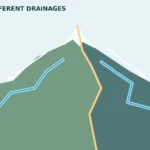
The Great Divide separates waters flowing toward different ocean drainage systems. It follows parts of the Rocky Mountain high country, but it is a line, not the perimeter of the entire mountain system. Mountain ranges can lie on either side of it; a river can rise in the Rockies without flowing in the same direction as a river in the next valley.
Rocky Mountain National Park provides a clear U.S. example. Its western waters feed the Colorado River system, while eastern waters belong to the Mississippi drainage. Farther north, the Canadian Rockies also supply rivers draining toward the Arctic Ocean and Hudson Bay, so a continent-wide explanation should not reduce all drainage to a simple Pacific-versus-Gulf split.
The U.S. Continental Divide map follows the drainage boundary itself. Use it for that narrower task rather than treating the outer edge of the colored Rocky Mountain regions as the divide.
6. Why the map shows more than a continuous wall
The Rockies contain high summits, broad valleys, plateaus, foothills and basins. Uplift gave the region its large-scale structure; erosion and glaciation helped shape the landforms visible today. Different processes matter in different ranges, which is why a single cartoon ridge cannot describe the whole system.
In Jasper, parallel ranges and river-cut gaps help explain how valleys cross and divide the mountain landscape. Around Grand Teton, the fault-bounded mountain front creates a sharp contrast with Jackson Hole. In Wyoming, extensive basin country separates major uplifts. These are not holes accidentally left out of the map: they are part of the geography the map needs to explain.
The geologic story also has more than one date. Older rocks can form the cores of mountains whose present relief developed much later. A map of rock age, a map of mountain-building structures and a modern relief map will therefore not show identical patterns. The plate tectonics explainer gives the larger process behind uplift and deformation without reducing every Rocky Mountain range to one event.
Use this map for regional orientation and comparison. It cannot identify safe hiking routes, road access, current closures or the exact elevation of a summit. Those tasks need local topographic information and the relevant land manager’s current guidance.
Frequently Asked Questions
Which is the highest mountain in the Rockies?
Mount Elbert in Colorado. The USGS identifies it as the system’s highest peak, at about 14,400 feet (4,400 meters). That rounded figure is enough for regional comparison; precise summit elevations depend on the survey and vertical reference used.
Is Canada’s Glacier National Park in the Rocky Mountains?
No. It is in the Columbia Mountains, including the Selkirk and Purcell ranges, west of the Canadian Rockies. It should not be confused with Glacier National Park in Montana, which lies in the U.S. Northern Rockies. Similar park names do not imply the same mountain-system location.
What Did We Learn Today?
The Rockies are best read as a system of ranges, basins and foothills across Canada and the United States. Named physiographic frameworks explain why maps can include lower terrain or differ at the margins. State boundaries locate the mountains, the Cordillera places them in a larger western belt, and the Continental Divide answers a separate question about where water flows.
Sources & Data Notes
The named Rockies follow the northern British Columbia–New Mexico convention in the BC geographical-name record. U.S. map subdivisions use the USGS/Fenneman physiographic framework; Canadian regions use NRCan’s separate framework. Generalized regional outlines are not precise mountain edges or navigation boundaries. The relief is for visual terrain interpretation, not summit measurement.
The regional overlays are derived from the original agency polygons, with Natural Earth II shaded relief and state/province boundaries. Colors identify landform regions, not elevation bands. At this scale, generalized outlines may cross precise state or river boundaries; they should not be used to decide jurisdiction membership at an individual site. Natural Earth and U.S. federal map data are public domain. Contains information licensed under the Open Government Licence – Canada. Regional data: NRCan physiographic regions and USGS physiographic divisions; relief: Natural Earth II.
- National Park Service: Rocky Mountain System Provinces
- BC Geographical Names: Rocky Mountains
- Natural Resources Canada: Physiographic Regions of Canada
- Parks Canada: Jasper geology
- Utah Geological Survey: Utah Landforms
- National Park Service: Pecos geology
- National Park Service: Grand Teton Geodiversity Atlas
- Parks Canada: The Columbia Mountains Natural Region
- National Park Service: Rocky Mountain National Park water quality
- USGS: Rocky Mountains, regional physiography and highest peak