A Caribbean map contains several different kinds of places: independent states, territories, constituent countries and parts of larger states. Island names alone do not tell you which is which. Haiti and the Dominican Republic share one island, while Saint Kitts and Nevis is one country across two main islands.
Using the United Nations M49 Caribbean subregion, there are 13 sovereign countries and 15 other statistical entries. Those other entries have different constitutional arrangements, so they are not all the same kind of territory. The Bahamas and Turks and Caicos are included; Bermuda and mainland countries are outside this particular list.
1. The Caribbean Map and Its Scope
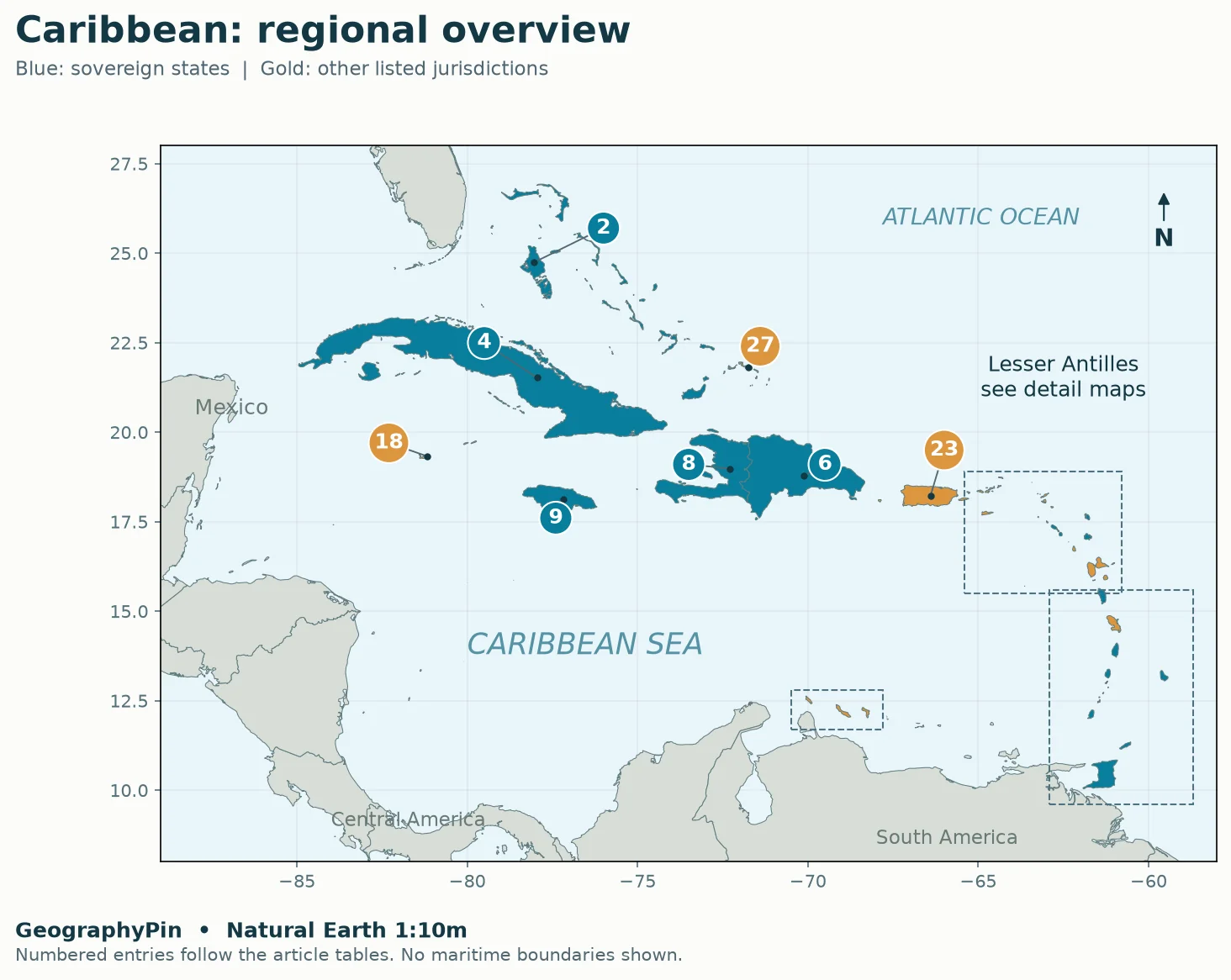
How to read the numbered map
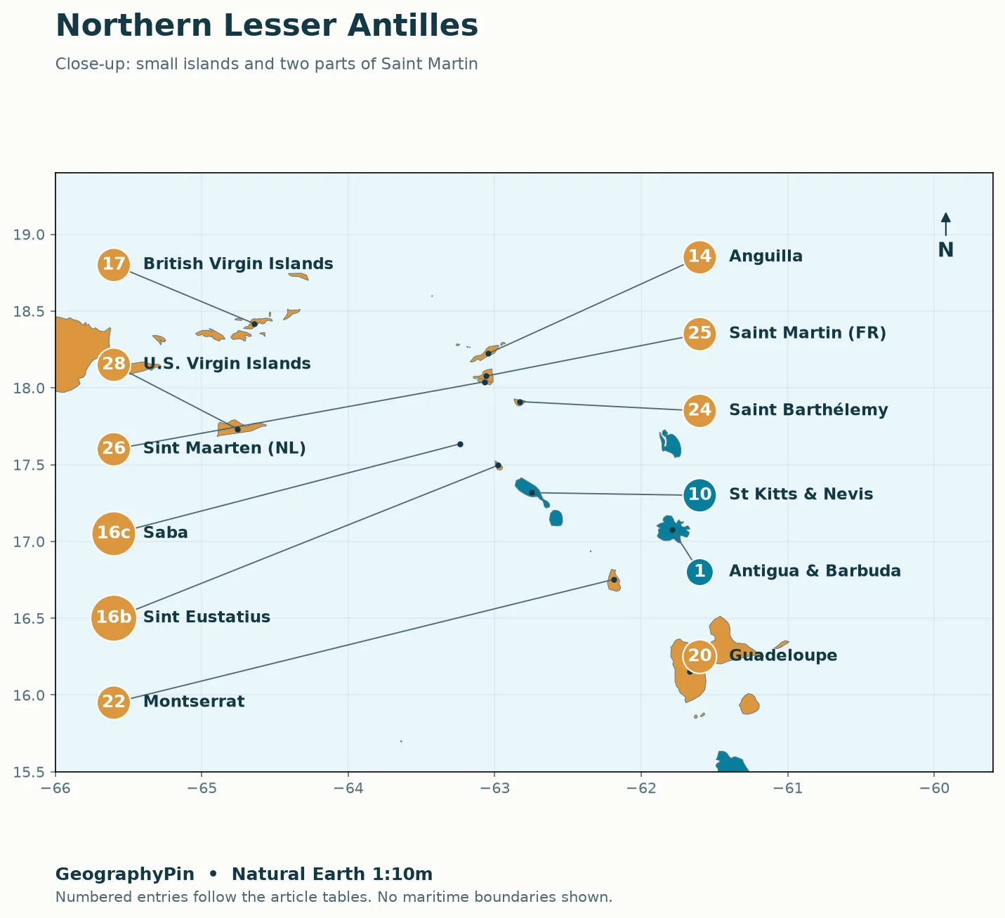
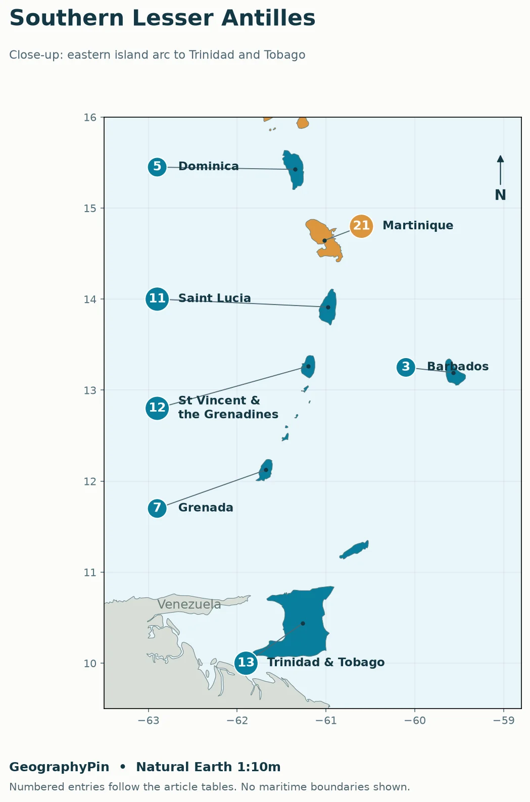
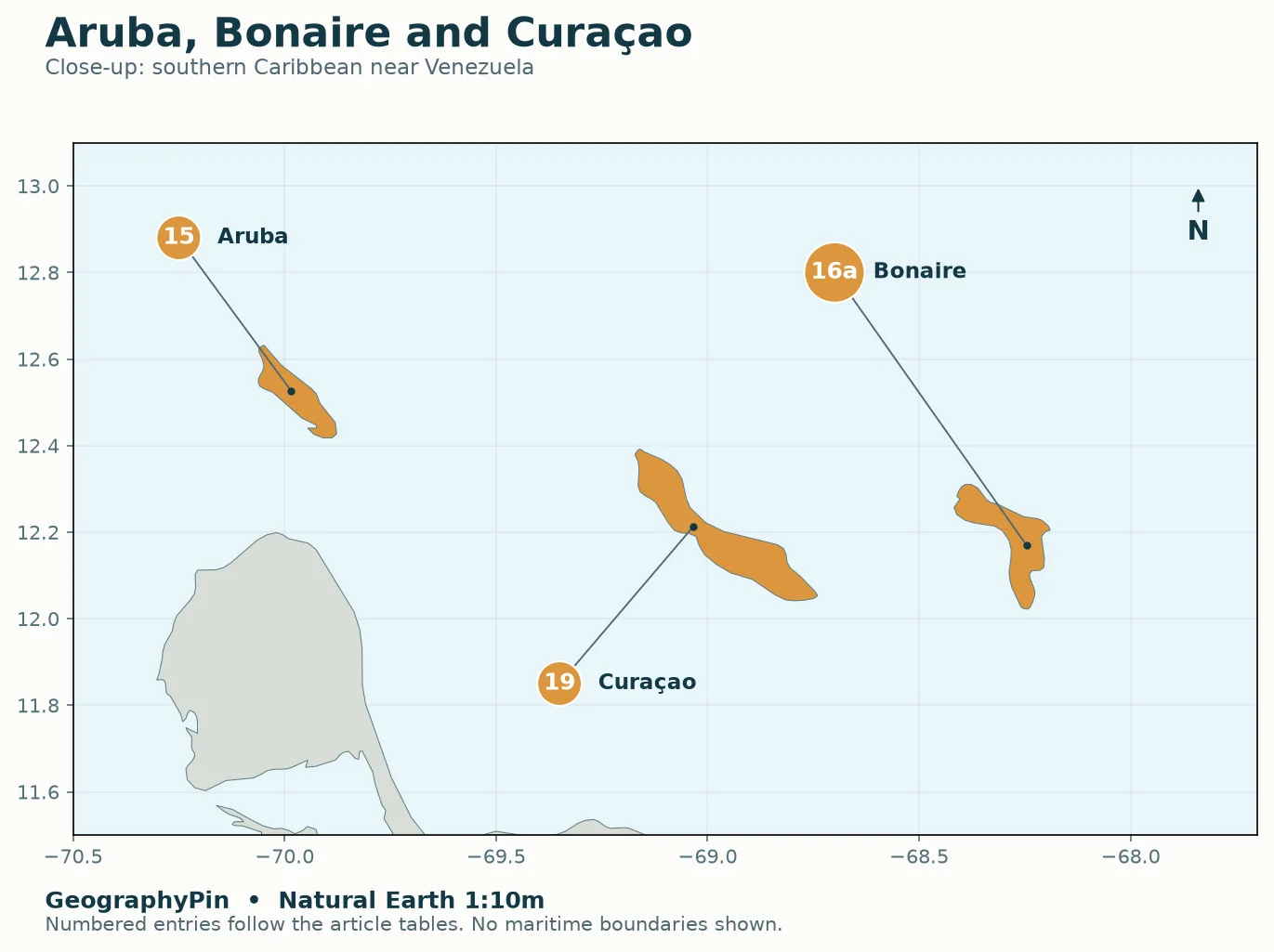
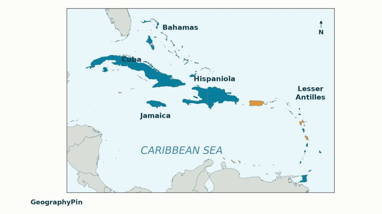
Numbers 1–13 identify sovereign states; 14–28 identify the other entries. Match each number with its row in the two tables below. Small islands need close-up views: a large marker does not mean a large island. Bonaire, Sint Eustatius and Saba share number 16 because the UN groups them as one statistical entry, even though they are separate islands far apart.

What the numbers mean
- 2 Bahamas
- 4 Cuba
- 6 Dominican Republic
- 8 Haiti
- 9 Jamaica
- 18 Cayman Islands
- 23 Puerto Rico
- 27 Turks and Caicos Islands
Open close-up: Northern Lesser Antilles

What the numbers mean
- 1 Antigua and Barbuda
- 10 Saint Kitts and Nevis
- 14 Anguilla
- 16b Sint Eustatius
- 16c Saba
- 17 British Virgin Islands
- 20 Guadeloupe
- 22 Montserrat
- 24 Saint Barthélemy
- 25 Saint Martin (French part)
- 26 Sint Maarten (Dutch part)
- 28 United States Virgin Islands
Open close-up: Southern Lesser Antilles

What the numbers mean
- 3 Barbados
- 5 Dominica
- 7 Grenada
- 11 Saint Lucia
- 12 Saint Vincent and the Grenadines
- 13 Trinidad and Tobago
- 21 Martinique
Open close-up: Aruba, Curaçao and Bonaire

What the numbers mean
- 15 Aruba
- 16a Bonaire
- 19 Curaçao
Original GeographyPin cartography using Natural Earth 1:10m coastlines. North is up; close-ups use different scales. Number 16 is split into 16a (Bonaire), 16b (Sint Eustatius) and 16c (Saba) only to locate the three islands in that one statistical entry.
The map is a location and status guide, not a map of maritime claims or territorial waters. It does not attempt to label every island, cay or small possession. Mainland coastlines provide geographic context, not extra entries in the country count.
Why use this particular boundary?
The UN M49 classification provides a reproducible list under Caribbean subregion code 029. Its purpose is statistical organization. It is not a declaration that culture, history or the Caribbean Sea stops at the same boundary.
This distinction matters because “Caribbean country” can mean an independent island state, a country belonging to a regional organization, or any country with a Caribbean coastline. Mixing those meanings produces a confusing total. Here, the main tables follow one convention; the sections below explain the wider meanings.
Political status is checked separately against governmental sources. A place receiving its own statistical code does not automatically become an independent country.
2. The 13 Independent Caribbean Countries
The independent-country list
These 13 entries are sovereign states. The location column helps you read the map; it is not a second political classification. Multi-island states count once. Haiti and the Dominican Republic are counted separately, although they share Hispaniola. The scope and political descriptions were checked in November 2026; constitutional arrangements can change.
| Map no. | Country | Map location | Useful distinction |
|---|---|---|---|
| 1 | Antigua and Barbuda | Lesser Antilles | Two names, one sovereign state. |
| 2 | Bahamas | Lucayan Archipelago | Atlantic archipelago north of Cuba. |
| 3 | Barbados | Eastern Caribbean | East of the main Lesser Antillean arc. |
| 4 | Cuba | Greater Antilles | West of Hispaniola, south of the Bahamas. |
| 5 | Dominica | Lesser Antilles | Between Guadeloupe and Martinique. |
| 6 | Dominican Republic | Greater Antilles | Eastern part of Hispaniola. |
| 7 | Grenada | Southern Lesser Antilles | North of Trinidad and Tobago. |
| 8 | Haiti | Greater Antilles | Western part of Hispaniola. |
| 9 | Jamaica | Greater Antilles | South of Cuba. |
| 10 | Saint Kitts and Nevis | Lesser Antilles | Two principal islands, one state. |
| 11 | Saint Lucia | Lesser Antilles | South of Martinique. |
| 12 | Saint Vincent and the Grenadines | Lesser Antilles | Saint Vincent and the northern Grenadines. |
| 13 | Trinidad and Tobago | Southern Caribbean | Two main islands close to northeastern Venezuela. |
For their place in the wider continent, see North America’s 23 sovereign countries and capitals. That larger count includes the Caribbean states rather than treating the Caribbean as a separate continent.
3. Other Caribbean Countries and Territories
The remaining 15 M49 entries are listed below. “Other” does not mean they all have the same legal status. Some are territories, some are constituent countries within a kingdom, and others form part of France or the Netherlands.
| Map no. | Country or area | Sovereign connection | Status |
|---|---|---|---|
| 14 | Anguilla | United Kingdom | British Overseas Territory |
| 15 | Aruba | Kingdom of the Netherlands | Constituent country; not a sovereign state |
| 16 | Bonaire, Sint Eustatius and Saba | Netherlands | Three public bodies; one UN M49 entry |
| 17 | British Virgin Islands | United Kingdom | British Overseas Territory |
| 18 | Cayman Islands | United Kingdom | British Overseas Territory |
| 19 | Curaçao | Kingdom of the Netherlands | Constituent country; not a sovereign state |
| 20 | Guadeloupe | France | Overseas department and region |
| 21 | Martinique | France | Territorial collectivity with departmental and regional responsibilities |
| 22 | Montserrat | United Kingdom | British Overseas Territory |
| 23 | Puerto Rico | United States | Unincorporated territory; commonwealth |
| 24 | Saint Barthélemy | France | Overseas collectivity |
| 25 | Saint Martin (French part) | France | Overseas collectivity |
| 26 | Sint Maarten (Dutch part) | Kingdom of the Netherlands | Constituent country; not a sovereign state |
| 27 | Turks and Caicos Islands | United Kingdom | British Overseas Territory |
| 28 | United States Virgin Islands | United States | Unincorporated territory |
Country, territory and public body are not interchangeable
The Dutch Caribbean is not the same as the Caribbean Netherlands. The Dutch government distinguishes the arrangements. Aruba, Curaçao and Sint Maarten are constituent countries within the Kingdom of the Netherlands. Bonaire, Sint Eustatius and Saba are public bodies of the Netherlands itself. Only the latter three are collectively called the Caribbean Netherlands. Bonaire lies near Aruba and Curaçao; Saba and Sint Eustatius lie far to the northeast.
The French entries also differ. The French Cour des comptes describes their different institutions. Guadeloupe is an overseas department and region. Martinique has a single territorial collectivity exercising departmental and regional responsibilities. Saint Barthélemy and the French part of Saint Martin are overseas collectivities. Calling all four “independent Caribbean countries” would be wrong.
Puerto Rico is not a sovereign state. The U.S. Department of the Interior’s definitions distinguish commonwealth from sovereign-state status. Its commonwealth designation does not change its status as an unincorporated U.S. territory. The U.S. Virgin Islands are also an unincorporated U.S. territory. The British Virgin Islands are a separate British Overseas Territory, not part of the U.S. Virgin Islands.
One island can contain two political jurisdictions
Hispaniola contains Haiti in the west and the Dominican Republic in the east. Saint Martin is shared by the French collectivity in the north and Sint Maarten, a country within the Kingdom of the Netherlands, in the south. The map’s two Saint Martin/Sint Maarten labels therefore refer to parts of the same island, not two neighboring islands.
4. Greater Antilles, Lesser Antilles and the Lucayan Archipelago
Island-group names describe geography, not independence. A group can contain sovereign states and non-sovereign places side by side.
- Greater Antilles: the large-island group centered on Cuba, Hispaniola, Jamaica and Puerto Rico. Hispaniola is an island name, not a country.
- Lesser Antilles: the smaller islands curving along the eastern Caribbean and, under broader usages, the southern island chain toward Venezuela. Barbados sits east of the main arc. Marginal groupings vary, so the map locates each place instead of using group names as exact borders.
- Lucayan Archipelago: the Bahamas and Turks and Caicos, north of the Antilles in the Atlantic. They belong in this Caribbean regional list even though they are not inside the Caribbean Sea proper.
The ABC islands are Aruba, Bonaire and Curaçao, off Venezuela. Their convenient geographic nickname conceals a political difference: Aruba and Curaçao are Kingdom constituent countries, while Bonaire is a public body of the Netherlands. No single ABC “country” exists.
For weather rather than political geography, use the separate Caribbean hurricane risk by island comparison. Country status and membership in an island group do not determine hurricane exposure.
5. Bermuda and the Mainland Caribbean
Why Bermuda, Belize, Guyana and Suriname are not in the main tables
Bermuda is in the North Atlantic, not the Caribbean Sea. UN M49 places it in Northern America rather than the Caribbean subregion. Cultural or institutional connections with the Caribbean do not move it south on the map.
Belize has a Caribbean coastline but is classified in Central America. Guyana and Suriname are in South America and face the Atlantic. All three are connected to the Caribbean community through CARICOM, but CARICOM membership and the M49 Caribbean subregion are different lists.
Mainland countries also border the Caribbean Sea, including Mexico, several Central American states, Colombia and Venezuela. A map of the Caribbean basin can reasonably include those coasts. It should not silently add all those countries to a table advertised as the 13 independent states in the island-centered M49 Caribbean grouping.
The useful question is not simply “Which total is right?” but “What is being counted?” Check whether a list means sovereign states, islands, statistical areas, coastlines or organizational members before comparing its number with another source.
Frequently Asked Questions
Is Dominica the same country as the Dominican Republic?
No. Dominica is a separate island state in the Lesser Antilles. The Dominican Republic occupies the eastern part of Hispaniola in the Greater Antilles.
Is Caribbean the name of an island?
No. It is a regional name, also used for the Caribbean Sea. The region contains many islands, and some definitions include neighboring mainland areas. A place described only as “in the Caribbean” therefore needs a more specific island or country name to locate it.
What Did We Learn Today?
A Caribbean map makes more sense when islands, sovereign states and administrative areas are kept separate. The declared UN scope supplies a consistent list, while the status tables explain why a Dutch constituent country, a French collectivity and a British Overseas Territory are not equivalent. Island groups help with location, but neither those groups nor regional organizations replace a clear counting rule.
Sources & Data Notes
The list follows UN M49 Caribbean subregion 029, with constitutional descriptions checked against the sources below in November 2026. Bonaire, Sint Eustatius and Saba are grouped as one statistical entry, not one island. This is not an exhaustive inventory of every offshore possession. Map coastlines use public-domain Natural Earth data; labels identify the table entries, and inset views use their own scales. No maritime boundaries are inferred. Political arrangements can change, and other Caribbean definitions have wider scope.
- United Nations Statistics Division: M49 geographic regions
- Government of the Netherlands: parts of the Kingdom
- U.S. Department of the Interior: definitions of insular-area political organizations
- French Cour des comptes: institutions of Guadeloupe, Martinique, Saint Barthélemy and Saint Martin
- UK House of Commons Library: introduction to the Overseas Territories
- CARICOM: Who We Are
- Bermuda Tourism Authority: Where Is Bermuda?
- Dutch Caribbean Species Register: geography of the Dutch Caribbean
- Natural Earth: public-domain map data and terms of use