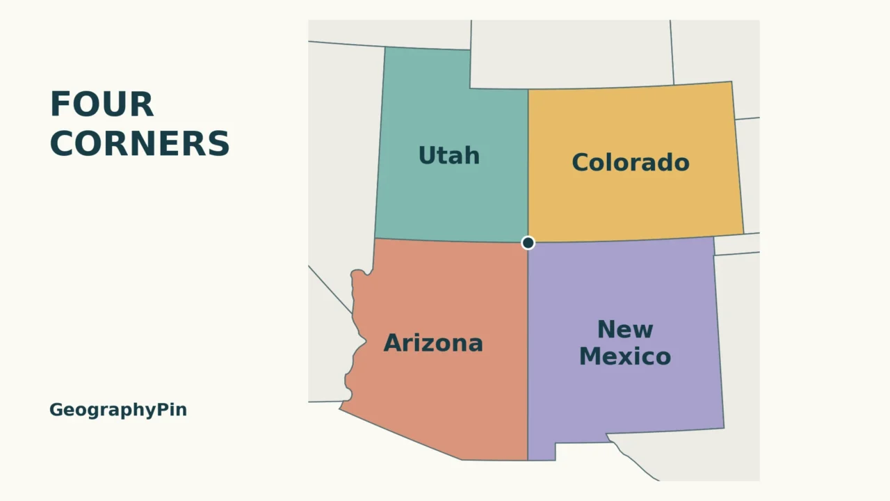
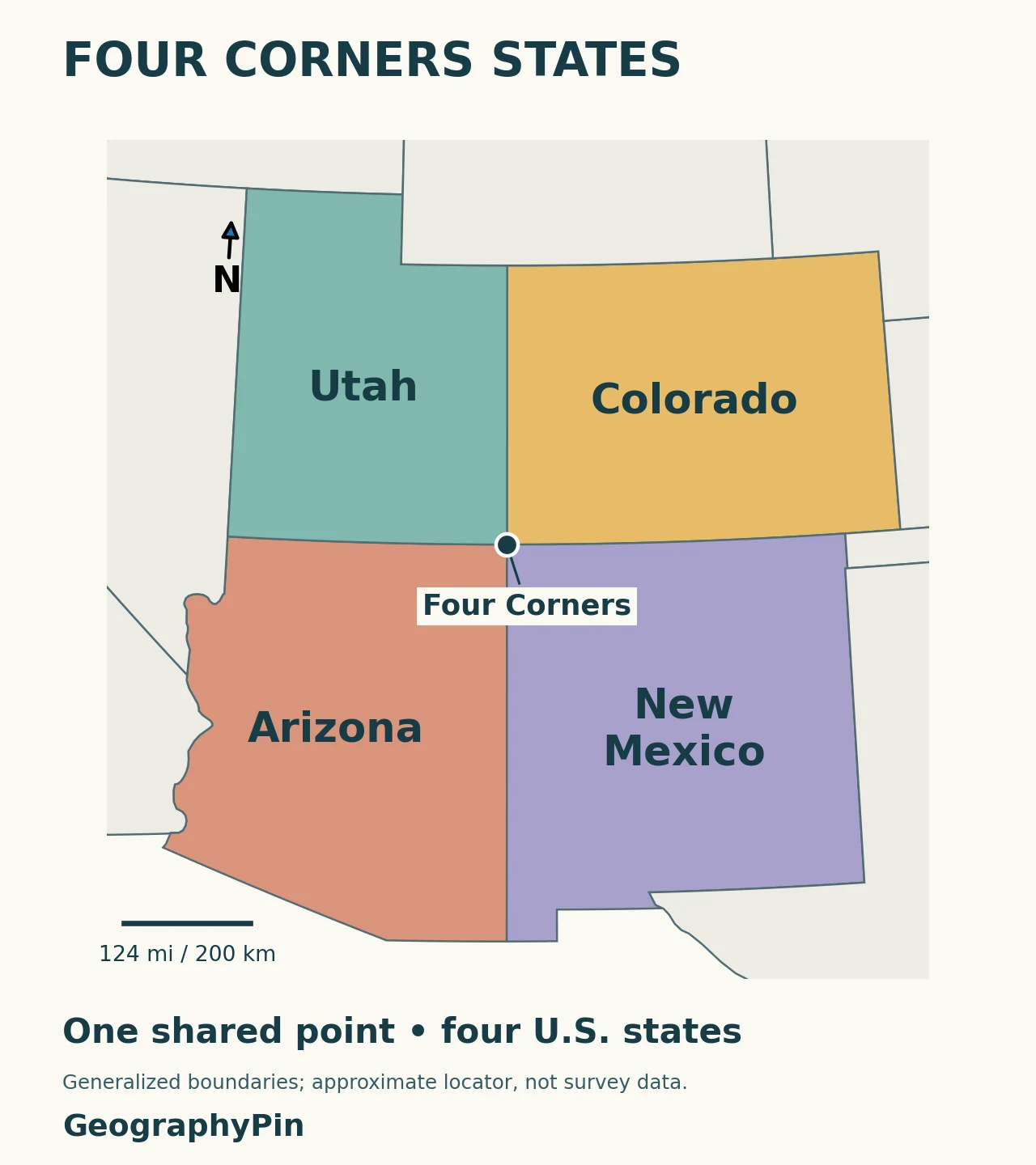
Four Corners is easier to remember as a pattern than as a list. Two states sit north of the meeting point, and two sit south. The map below shows their full shapes so you can place the famous intersection within the wider western United States.
Arizona, Colorado, New Mexico and Utah meet at Four Corners, the only point in the United States shared by four states. On a north-up map, Utah is northwest of the point, Colorado northeast, Arizona southwest and New Mexico southeast. The Four Corners Monument marks that intersection.
Start here: use the state arrangement, check point contact versus a boundary line, or read why the monument is not misplaced.
1. Four Corners States Map
Read the four positions, not just the names
Start in the upper-left corner around the dot: Utah. Move clockwise to Colorado, then New Mexico, then Arizona. That sequence gives you the order around the meeting point, rather than an alphabetical list that says nothing about location.
| State | Direction from the point | Corner of the state |
|---|---|---|
| Utah | Northwest | Southeastern corner |
| Colorado | Northeast | Southwestern corner |
| Arizona | Southwest | Northeastern corner |
| New Mexico | Southeast | Northwestern corner |
Notice the difference between those last two columns. Colorado lies northeast of the point, so the point is at Colorado’s southwestern corner. Reversing that relationship is an easy map-reading mistake.
For the geography beyond the intersection, see our Colorado map and state guide and New Mexico map and state guide. Four Corners is one part of those states, not a description of all their landscapes.
2. Which States Share a Line or Just a Point?
Diagonal neighbors meet only at the corner
The arrangement explains why “touch” and “share a boundary line” are not always interchangeable. Arizona and Colorado are diagonally opposite; so are Utah and New Mexico. Each diagonal pair meets at Four Corners, but does not share a boundary segment extending away from it.
The other pairs have boundary lines: Utah–Colorado, Colorado–New Mexico, New Mexico–Arizona and Arizona–Utah. On the map, you can follow each of those lines outward from the central dot. This is useful when a quiz asks which states border one another: check whether its definition includes contact at a single point.
The name “Four Corners” can also refer loosely to the surrounding region. That broader usage is different from the precise state intersection. This map colors the four whole states for identification; it does not claim they form one official region with a separately defined outer boundary.
3. The Monument and Its Location
The accepted boundary marker matters
The Four Corners Monument is a Navajo Tribal Park. Navajo Nation Parks & Recreation identifies it as the place where the four states meet. If you plan to visit, check that official page for current opening arrangements and admission information rather than treating an educational map as a travel update.
You may encounter claims that the monument is in the wrong place. The National Geodetic Survey’s explanation rejects that conclusion. Historical surveying, different longitude references and modern coordinate measurements can produce technical questions about intended positions. They do not move an accepted boundary monument.
NGS explains that the Arizona–New Mexico boundary was originally referenced to the Washington meridian, not simply to 109° west of Greenwich. More importantly, it states that the accepted physical monument is the authority for the boundary intersection. A modern map grid or a handheld coordinate reading is not grounds for relocating the meeting point.
Our dot has a much simpler job: to locate Four Corners on a regional educational map. It is deliberately not a set of survey coordinates, a property-boundary determination or driving directions. The visible width of the dot also exaggerates the size of the actual meeting point, as locator symbols normally do.
Frequently Asked Questions
Is Four Corners a national park?
No. Four Corners Monument is a Navajo Tribal Park managed by Navajo Nation Parks & Recreation, not a National Park Service unit. Use the tribal park’s official visitor information when planning a visit.
Is Four Corners the same place as Monument Valley?
No. Four Corners Monument and Monument Valley are separate Navajo Tribal Parks. Do not use one name as a substitute for the other when choosing a destination.
What Did We Learn Today?
Four Corners is the shared point of Arizona, Colorado, New Mexico and Utah. Their map arrangement distinguishes neighboring states that share a line from diagonal pairs that touch only at the corner. The monument marks the accepted intersection, while a generalized regional map helps explain its position without replacing surveying or visitor information.
Sources & Data Notes
- Navajo Nation Parks & Recreation: Four Corners Monument, for the four-state intersection and park identity.
- Navajo Tribal Parks directory, distinguishing Four Corners from Monument Valley.
- NOAA National Geodetic Survey: Why the Four Corners Monument Is in Exactly the Right Place, for the boundary-marker and historical coordinate explanation.
- Natural Earth 1:50 million states and provinces, public-domain generalized outlines.
Map method: GeographyPin colored the four state polygons from Natural Earth and projected them with a regional Lambert conformal conic projection. State-label anchors were checked inside their polygons. The dot is a rounded regional locator, not the monument’s surveyed GPS position. The map does not delineate tribal lands; its scale is approximate. No monument photograph or third-party map has been reproduced.