The decisive question is not only where the water flows. It is what the treaty, judgment, or boundary commission says the border follows.
Some river borders can shift when a treaty makes the boundary follow a changing channel, but the countries discussed here do not all gain or lose legal territory every year. Rivers may move annually; the border may follow gradually, remain tied to an older channel, or change only through joint survey, treaty, or court judgment.
How to use this article: Start with the fast legal test, then compare the Muhuri fixed-boundary solution, the Rio Grande treaty system, and the final physical-versus-legal distinction.
How River Borders Work: Thalwegs, Accretion, and Fixed Lines
A river border is not defined by physical geography alone. The controlling instrument may place the boundary on a bank, at a median line, along a thalweg, through surveyed coordinates, or on the channel as it existed at a particular date. Two rivers can shift in the same way while producing different legal results.
The Fastest Way to Read a River-Border Claim
Before accepting a claim that a country gains or loses land every year, check three things:
- What line does the legal text use? It may be the thalweg, the middle of normal flow, one bank, a fixed coordinate line, or a historical channel.
- What kind of river change occurred? Gradual erosion and deposition are different from a sudden cutoff, flood-driven jump, or artificial diversion.
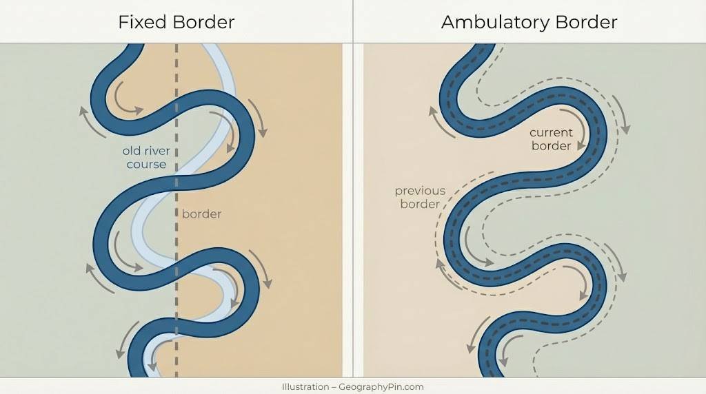
- Is the boundary ambulatory or fixed? An ambulatory line can follow the river; a fixed line stays where it was legally established even when the water moves.
Without those answers, “the border changes every year” usually describes the landscape more accurately than it describes sovereignty.
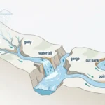
Thalweg, Accretion, and Avulsion
A thalweg is commonly the deepest or principal navigable channel, although treaties define it in different ways. Accretion is gradual change caused by erosion on one bank and deposition on another. Avulsion is a sudden channel change, such as a cutoff during a flood. These concepts help explain river boundaries, but they are not universal automatic rules; the controlling treaty or judgment can preserve an older line or create its own procedure.
The 1970 U.S.–Mexico Boundary Treaty, for example, says lateral movement by erosion and alluvial deposition keeps the boundary in the middle of the normal-flow channel. It then supplies separate procedures for other kinds of channel change.
Core Rules in One Glance
The useful distinction is not “moving river” versus “stable river.” It is current channel, historical channel, or fixed line.
| Concept | What It Can Mean for the Border |
|---|---|
| Thalweg or mid-channel | The legal line follows a defined part of the river, but the treaty must specify which channel and how islands are treated. |
| Gradual accretion | An ambulatory boundary may move as one bank erodes and the opposite bank gains sediment. |
| Sudden avulsion | The legal line may remain in the former channel, or a treaty may prescribe restoration, compensation, or another procedure. |
| Historical channel | A court or treaty can tie the border to the river as it existed at a critical date, so later channel movement does not automatically move sovereignty. |
| Fixed coordinates or demarcation | The water can shift while the legal line remains unchanged unless the countries formally agree to revise it. |
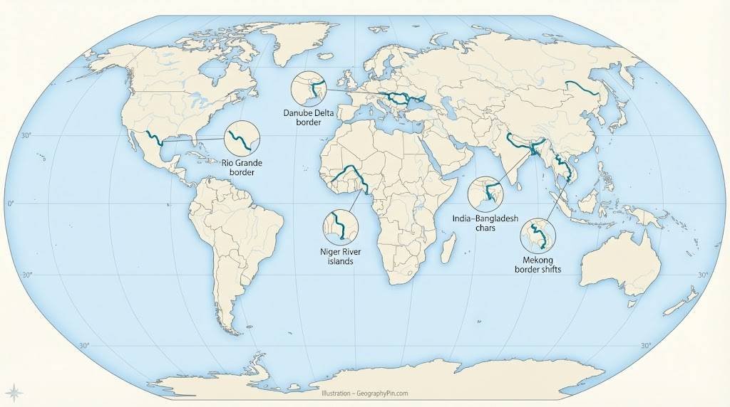
| River or Sector | Countries | Physical Change | Legal Rule or Status |
|---|---|---|---|
| Muhuri River and nearby char-forming systems | India–Bangladesh | Bank erosion, sediment deposition, and shifting chars | The 1974 agreement and 2011 protocol describe the Muhuri/Belonia line as fixed, not an automatic annual shift. |
| Rio Grande | United States–Mexico | Lateral erosion, deposition, separated tracts, and engineered channels | The 1970 treaty generally keeps the boundary in the normal-flow channel during gradual lateral movement; the IBWC surveys, stabilizes, and rectifies where authorized. |
| Niger River | Benin–Niger | Multiple channels and river islands | The 2005 ICJ judgment used the main navigable channel as it existed at independence and specified 154 boundary points. |
| Mekong River | Thailand–Laos | Seasonally exposed islands, bank erosion, and channel change | Historical treaties use thalweg rules with special treatment for islands and former channels; Thai official records from 2018–2021 described bilateral survey and demarcation as ongoing. |
| Chilia/Kiliya arm of the Danube | Romania–Ukraine | Moving channels, floods, sediment, and mouth-bar growth | The 2003 border-regime treaty says the state border remains unchanged unless the countries agree otherwise; natural coordinate changes require joint protocols. |
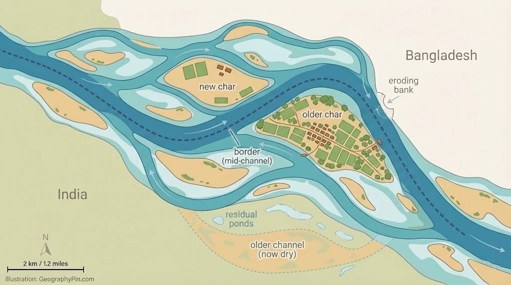
India–Bangladesh: Chars, the Muhuri River, and a Fixed Line
A Delta That Never Stands Still
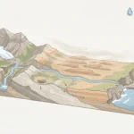
The Ganges–Brahmaputra–Meghna system is one of the clearest examples of a physically mobile river landscape. Chars—newly deposited river islands or exposed sediment lands—can appear, change shape, and disappear seasonally. Some support farms and settlements, while erosion and flooding can force residents to move repeatedly.
That movement does not prove that the entire India–Bangladesh frontier is ambulatory. The Jamuna example shows how rapidly a major river can reshape land inside Bangladesh; the legal effect on an international boundary must be checked sector by sector.
The Muhuri Case: Moving Water, Fixed Boundary
The most relevant border example is the Muhuri River in the Belonia sector. The 1974 India–Bangladesh Land Boundary Agreement placed the boundary along the river’s midstream at the time of demarcation and expressly described it as fixed. The 2011 protocol again defined an agreed line to the existing Muhuri channel, called it a fixed boundary, and provided for embankments intended to stabilize the river’s course.
This arrangement deliberately separates the legal frontier from later bank erosion or channel drift. Physical land may still be lost or deposited, but sovereignty does not automatically follow every new bend.
The 2015 implementation of the Land Boundary Agreement exchanged enclaves and settled long-running land-boundary issues. It did not establish a single moving mid-channel rule for the whole shared river system.
What River Movement Still Means for Communities
A fixed legal line does not remove the human consequences of a moving river. Erosion can take homes and fields, cut roads, separate communities from services, and complicate access for local authorities. Residents do not automatically change nationality because a bank collapses; officials must apply the surveyed boundary while responding to the physical loss of land.
United States–Mexico: The Shifting Rio Grande
The Border Still Follows the River—Under Rules
The Rio Grande forms about 1,254 miles (2,019 kilometers) of the United States–Mexico boundary from the El Paso–Ciudad Juárez area to the Gulf of Mexico. The accurate description is not simply “fixed since 1970.” The 1970 Boundary Treaty says the line generally runs through the middle of the channel occupied by normal flow, or through the normal-flow channel with the greatest average width when there is more than one.
When the river moves laterally by eroding one bank and depositing alluvium on the other, the treaty says the international boundary continues to follow that normal-flow channel. The International Boundary and Water Commission must delineate the line on maps and conduct surveys at intervals no longer than ten years.
Chamizal and the 1970 Boundary Treaty
The Chamizal dispute grew from the Rio Grande’s gradual southward movement near El Paso during the nineteenth century. The 1963 Chamizal Convention resolved the dispute by relocating and stabilizing about 4.35 miles (7 kilometers) of channel. The 1970 treaty then resolved remaining boundary differences and created procedures for future channel changes, separated tracts, stabilization, and rectification.
Some reaches are therefore highly engineered and physically stable, while the broader legal framework still treats the normal-flow channel as the boundary in specified circumstances. A sudden cutoff or a tract isolated by the river does not become a simple, instant territory swap; the treaty and the IBWC process control what happens next.
The river can also alter daily access without changing the legal answer immediately. Eroded banks, new sandbars, or a blocked crossing can change how residents and officials use the border even while both governments apply the treaty’s surveyed line.
West Africa: Niger River Islands Between Benin and Niger
The River Moves, but the Judgment Uses a Historical Channel
The Niger River divides around islands and multiple channels along the Benin–Niger frontier. The legal dispute centered on which channel formed the boundary and which country owned islands including Lété Goungou.
In 2005, the International Court of Justice held that the boundary follows the line of deepest soundings of the main navigable channel as it existed at the dates of independence in August 1960. The judgment identified 154 points, allocated 25 islands, and placed Lété Goungou in Niger.
What the ICJ Decision Fixed
The Court used a 1970 engineering report to reconstruct the main navigable channel at the critical date. That makes this a historical-reference boundary, not a present-day line that automatically moves each year with every new sandbar or channel shift.
The river’s physical changes still matter. They can affect navigation, fishing, grazing, access to islands, and local policing. The historical evidence reviewed by the Court even included the administration of grazing permits and territorial jurisdiction. But the legal ownership of the islands follows the judgment unless the two states later agree on a different arrangement.
Mainland Southeast Asia: Mekong River Shifts Along Thailand–Laos
The Mekong Boundary Is Not a Simple Midline
Thailand and Laos share about 688 miles (1,108 kilometers) of river boundary, including roughly 593 miles (955 kilometers) along the Mekong. Their boundary comes from a series of Siamese–French agreements. Thai official records from 2018 and 2021 described joint river-boundary survey and demarcation as continuing work.
A U.S. State Department boundary study summarizing the historical conventions describes a thalweg rule where no islands exist. Where islands occur, the boundary follows the channel nearest the Thai shore, leaving the islands to Laos. At low water, some islands can become attached or nearly attached to the Thai bank, yet the former thalweg can remain legally relevant.
That is why a newly exposed bar or an eroding bank cannot be translated directly into “Thailand lost land” or “Laos gained land.” The island rule, the former channel, and the bilateral demarcation process all matter.
Bank Erosion, Dams, and Sediment
The Mekong’s banks and channels remain physically active. Erosion can remove farmland and force buildings or paths farther inland. At basin scale, the Mekong River Commission reports that sediment trapping by dams and extensive sand and gravel extraction have sharply reduced sediment loads, changing river and delta morphology. Its Council Study found that dam-related sediment trapping can increase river erosion and the need for bank protection downstream.
These pressures can make the border landscape harder to manage, but they do not replace the treaty. A physical bank retreat may create an urgent local problem without causing an automatic transfer of sovereignty.
Survey and Demarcation, Not Routine Micro-Adjustments
Thailand’s foreign ministry reported that the two countries had jointly completed a new Mekong boundary map and were continuing negotiations on terms for surveying and demarcating the river line. Later official reporting still described river-boundary work as an active bilateral process. That supports a careful description—ongoing clarification and demarcation—not an unsupported claim that frequent territorial micro-adjustments occur automatically.

Europe: Danube Delta Change Along the Romania–Ukraine Border
A Dynamic Delta Around a Treaty-Managed Border
The Chilia, also spelled Kiliya, arm of the Danube forms an international border between Romania and Ukraine. The surrounding delta is physically dynamic, shaped by moving channels, seasonal floods, sediment delivery, dredging, and navigation works.
The arm reaches the Black Sea, where river sediment and coastal processes continually reshape mouths, bars, and wetlands. Those changes affect habitats, navigation routes, and local access, but they do not by themselves settle the interstate boundary.
Why New Bars Do Not Redraw the Border Each Year
Romania and Ukraine signed a state-border regime treaty in 2003, and it entered into force on May 27, 2004. Article 1 carries forward the demarcated border and states that the line remains unchanged unless the two countries agree otherwise. If natural phenomena make coordinate changes necessary, the Joint Commission must record them through new protocols.
This is not an automatically ambulatory delta border. New mouth bars, a deepening branch, or a shifting shoreline can change the physical setting, while the state line remains governed by demarcation documents and bilateral protocol.
Engineering Changes the Channel, Not the Treaty
Navigation channels, dredging, embankments, and river-training works can alter flow and sediment movement in the delta. UNESCO and Ramsar materials identify navigation works in this border area as a transboundary environmental concern. The legal border still follows the bilateral border regime rather than whichever branch happens to carry more water in a given season.
Do These Borders Really Change Every Year?
Physical Change Versus Legal Change
Physically, many of these rivers change every year. Banks retreat, sediment accumulates, islands emerge, and channels divide or reconnect. Legally, only some boundary lines follow those changes.
- Rio Grande: gradual lateral erosion and deposition can move the treaty boundary with the normal-flow channel, subject to the 1970 treaty and IBWC procedures.
- Muhuri River: India and Bangladesh chose a fixed line for the Belonia sector.
- Benin–Niger: the ICJ tied the line to the main navigable channel at the 1960 critical date.
- Thailand–Laos Mekong: historical rules apply thalweg and island exceptions, while official records from 2018–2021 described bilateral demarcation work.
- Romania–Ukraine: the 2003 treaty says the border remains unchanged unless the countries agree otherwise.
The title is therefore accurate only with a qualification: the river landscape may change every year, but the legal border changes yearly only where the controlling rule allows it.
How to Check a Moving-Border Claim
- Identify the exact river segment. One river can use different boundary rules in different reaches.
- Find the controlling instrument. Look for a treaty, demarcation protocol, court judgment, or binding boundary-commission decision.
- Check the reference line. Is it the current channel, the normal-flow channel, a former thalweg, a historical snapshot, or fixed coordinates?
- Separate landform change from sovereignty. A vanished island, eroded field, or new bar may create a practical crisis without transferring legal territory.
Climate and Engineering Change the River, Not the Rule
Changes in rainfall, floods, sea level, dams, dredging, and sediment extraction can alter erosion and deposition. Mekong studies link sediment trapping and extraction to reduced sediment loads and greater erosion pressure, while Bangladesh and Danube sources document recurring erosion and dynamic channels.
Those pressures may increase the cost of surveys, bank protection, compensation, and cross-border coordination. They do not, by themselves, rewrite a treaty or court judgment.
Frequently Asked Questions
Which countries have river borders that can legally move?
The United States and Mexico provide a clear treaty example: gradual lateral movement of the Rio Grande can move the boundary with the normal-flow channel. Other river boundaries may also be ambulatory, but the answer always depends on the controlling treaty or judgment.
Does a shifting river automatically transfer territory?
No. A boundary may follow the current channel, remain in a former channel, use a historical snapshot, or stay fixed by coordinates. Physical erosion is evidence that the landscape changed, not proof that sovereignty changed.
Do residents change nationality when a riverbank erodes?
Not automatically. Nationality and jurisdiction follow the legally recognized boundary, not the visible waterline alone. Where land is eroded or cut off, governments may need surveys, access arrangements, or treaty procedures before any legal status changes.
How do countries keep track of river borders?
They use joint surveys, boundary maps, aerial or satellite imagery, field markers, hydrological measurements, and bilateral commissions. The IBWC and the Thai–Lao Joint Boundary Commission show how states combine technical mapping with treaty interpretation.
Can climate change, dams, or sand mining make disputes more likely?
They can increase physical erosion, sediment imbalance, channel instability, and pressure on riverside communities. That can create more disputes over access or protection, but the legal border still depends on the applicable agreement or judgment.
What Did We Learn Today?
River channels can change every season, but international borders do not all follow them in the same way. The Rio Grande treaty allows gradual channel-following movement, while the Muhuri sector, the Benin–Niger judgment, and the Romania–Ukraine treaty rely on fixed or historical references; the Mekong applies its own thalweg and island rules. The treaty—not the water alone—decides whether territory changes.
Sources & Data Notes
Principal sources for this update included the 1970 U.S.–Mexico Boundary Treaty and International Boundary and Water Commission materials; India’s Ministry of External Affairs texts for the 1974 Land Boundary Agreement and 2011 Protocol; the International Court of Justice’s 2005 Benin/Niger judgment; Thai foreign-ministry records and the U.S. State Department’s Thailand–Laos boundary study; Mekong River Commission assessments; the 2003 Romania–Ukraine border-regime treaty in the United Nations Treaty Collection; UNESCO and Ramsar materials; and World Bank and NASA river-morphology references. Distances are rounded, and each legal effect is described under its own instrument rather than as a universal river-border rule. This article was prepared and editorially reviewed by Zurab Koniashvili (Z.K. Atlas), who completed the final factual checks and publication approval. AI tools may have assisted during the editorial process, including with language refinement and the creation or editing of visual materials.