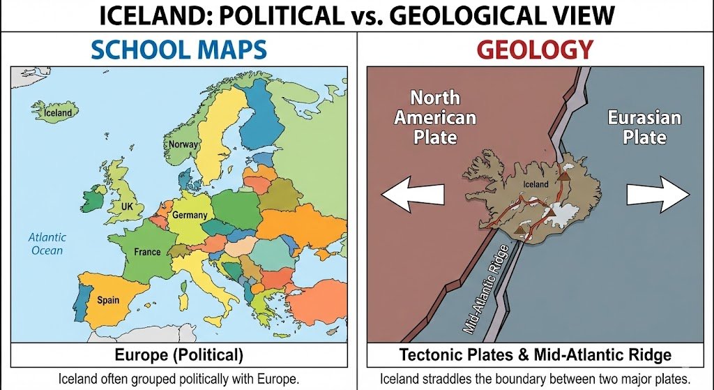
Iceland looks simple on a map and complicated the moment you ask what continent it belongs to. The confusion comes from mixing geology with human geography: the island sits on a plate boundary, but most institutions, maps, and practical classifications still place it in Europe.
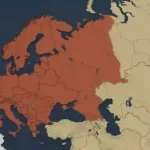
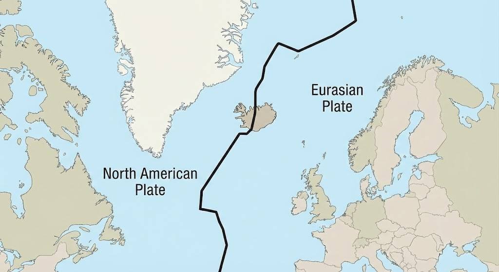
Iceland is usually treated as a European country. The complication is geological: the island straddles the Mid-Atlantic Ridge, so one side aligns with the North American plate and the other with the Eurasian plate. In everyday geography, politics, sport, and statistics, though, Iceland is grouped with Europe.
How to use this article: jump straight to the school-test answer, what the plate boundary really changes, why Europe wins in practice, or why this question is useful at all.
Quick Answer: Geology Says “Both”, Human Geography Says “Europe”
Iceland is one of those places where two correct answers can exist at once, depending on the system you are using. In tectonic terms, Iceland sits on the boundary between the North American and Eurasian plates. In human geography, it is overwhelmingly treated as a Nordic and European state.
The cleanest way to put it is this: if the question is about continents in the way schools, atlases, institutions, and regional groupings use them, the answer is Europe. If the question is about plate tectonics, Iceland is a special case because the island rises directly across an active spreading boundary.
What to say on a school test
For a standard geography test, quiz, or atlas-style question, “Europe” is the expected answer. That is how the United Nations’ regional system places Iceland, how European sports bodies treat it, and how most educational materials frame it in practice.
The location in plain geographic terms
Iceland lies in the North Atlantic between Greenland and northwestern Europe, just south of the Arctic Circle. That in-between position is exactly why people argue about it, but proximity alone does not decide continent labels in everyday use.
| System | Best way to classify Iceland |
|---|---|
| Plate tectonics | A ridge-crossing island split between the North American and Eurasian plates. |
| School-continent answer | Europe. |
| Regional identity | Nordic and Northern European. |
| Political and security alignment | Firmly tied into European and transatlantic institutions. |
| Everyday map usage | Usually shaded, labeled, or grouped with Europe. |
Continents, Plates, and Regions Are Different Systems
A lot of the confusion disappears once you separate three ideas that people often mash together: tectonic plates, continents, and world regions. Plates are geological structures. Continents are partly historical and educational map categories. Regions are practical groupings used by institutions, trade systems, diplomacy, and sport. They overlap sometimes, but they are not the same thing.
What the plate boundary changes — and what it does not
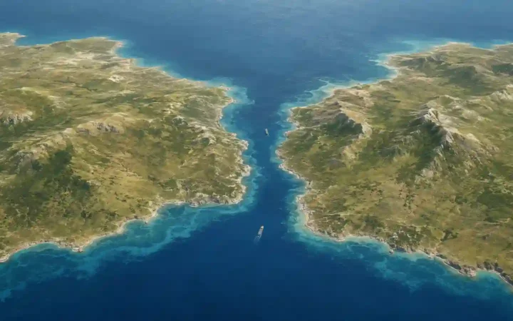
Iceland’s geology is genuinely unusual. USGS describes the country as splitting along the spreading center between the North American and Eurasian plates, and Þingvellir is one of the clearest on-land places where that rifting can be seen. What this changes is the geological story of Iceland. What it does not automatically change is the continent label used by schools, atlases, or institutions.
That is why statements like “Iceland is in North America” can sound half-right and still mislead. They usually take a true tectonic fact and stretch it into a human-geography conclusion that most formal classification systems do not follow.
Why Iceland Is Treated as European in Practice
The practical answer lands on Europe because Iceland’s language, settlement history, political habits, and institutional ties point there far more strongly than they point toward North America. Iceland is part of the Nordic sphere, participates in European economic structures, and has long been embedded in the transatlantic security system from a European-facing position.
The institutional reason Europe wins in practice
A short timeline makes the logic clear. Iceland was a founding NATO member in 1949, a founder of the Nordic Council in 1952, joined EFTA in 1970, entered the EEA framework when it came into force in 1994, and became part of the Schengen area in 2001. It later applied for EU membership in 2009, opened accession talks in 2010, put them on hold in 2013, and in 2015 asked not to be regarded as an EU candidate country.
| Year | Milestone | Why it matters here |
|---|---|---|
| 1949 | Founding member of NATO | Places Iceland in the core North Atlantic security framework with Europe and North America. |
| 1952 | Founder of the Nordic Council | Confirms Iceland’s place in the Nordic political and cultural family. |
| 1970 | Joined EFTA | Deepened Iceland’s economic integration with Europe. |
| 1994 | EEA Agreement entered into force | Brought Iceland into the wider European single-market framework. |
| 2001 | Schengen rules became applicable | Strengthened Iceland’s practical integration with much of Europe. |
| 2009–2015 | EU application, negotiations, hold, and later request not to be treated as a candidate | Shows proximity to Europe’s institutional orbit even without EU membership. |
None of this makes Iceland an EU member, and none of it erases the island’s geological split. It does explain why, in any practical conversation about regions, Iceland is treated as European first and only described as “between North America and Europe” as a geological qualifier.
How Maps, Atlases, and Data Systems Place Iceland
How formal classification systems handle Iceland
Formal systems are the easiest place to check because they have to choose a box. The UN regional grouping places Iceland with Northern Europe, the UN’s Western European and Others Group includes Iceland, UEFA treats Iceland as one of Europe’s national associations, and European statistical work routinely includes Iceland alongside the EFTA states in the wider European data space.
Once those frameworks are in place, school maps and general-reference materials usually follow the same logic. So although Iceland’s geology invites a more technical answer, most map users encounter it as part of Europe, especially Northern Europe or the Nordic region.
Why the Question Matters
This is not just a trivia trap. Iceland is a useful reminder that geography works with different layers at once: physical structure, regional identity, political alignment, and institutional practice. A place can be geologically unusual without being reclassified into a different continent in everyday human geography.
Why this distinction is useful
If you are answering a classroom question, booking a Europe-focused trip, reading international statistics, or following Iceland in football, “Europe” is the practical answer. If you are talking about crustal spreading, volcanism, or the Mid-Atlantic Ridge, then Iceland’s North American–Eurasian split becomes the important part. Different questions need different geographic tools.
FAQ
For a school test, should I answer Europe or North America?
Answer Europe. That is how standard regional groupings and most educational map conventions treat Iceland, even though its geology is more complicated.
Is Iceland physically in both continents?
Not in the simple school-map sense. The accurate geological statement is that Iceland straddles the North American and Eurasian plates; that is not the same thing as saying it is half a North American country in everyday regional geography.
Is Reykjavík in Europe?
In practical human geography, yes. Reykjavík is the capital of a country that institutions and regional systems place with Europe, even though southwest Iceland sits close to the active plate boundary zone.
Is Iceland part of Scandinavia?
It is clearly part of the Nordic group. “Scandinavia” is often used more narrowly for Denmark, Norway, and Sweden, so Iceland is better described as Nordic unless someone is using the broader, looser version of the term.
Why do some people still say North America?
Because the tectonic fact is striking and memorable: Iceland really does sit across the boundary between the North American and Eurasian plates. The problem is that people often carry that geological fact into a continent label that most formal regional systems do not use.
What Did We Learn Today?
Iceland is the rare country that makes a simple continent question worth slowing down for: geologically it straddles the North American and Eurasian plates, but in the way maps, institutions, statistics, sport, and everyday geography actually work, it is treated as European. The shortest accurate answer is not “pick one and ignore the rest,” but “Europe in practice, plate-boundary both in geology.”
Sources & Data Notes
For this piece, I cross-check the geology side with USGS and UNESCO-style site material around Iceland’s rift setting, then anchor the classification side with UN regional groupings, Nordic Council pages, NATO, EFTA, EU institutional summaries, and a few current statistical references where needed. I keep figures rounded when they are not the main point, and newer releases can shift small details without changing the bigger classification logic. Some visuals on GeographyPin may be AI-assisted, especially simplified explanatory ones, but the editorial framing and final wording are still shaped manually.