A line that looks like a detour on a flat map can be the shorter way across Earth. The trick is to separate the route on the globe from the way a map draws it.
Flight paths often look curved because a flat map distorts routes on Earth’s curved surface. On a spherical Earth, the shorter great-circle arc between two points is the shortest surface route, but it usually bends on a Mercator map. Actual flights also respond to winds, weather and airspace requirements, so their routes need not follow that geometric minimum.
How to use this article: Compare the Mercator view with the gnomonic view, then distinguish a geometric route from an operational flight.
1. The shortest path depends on the surface
On a flat sheet of paper, the shortest connection between two points is a straight segment. On a sphere, a route constrained to the surface follows different geometry. Imagine stretching a string taut across a globe between two places: the shorter surface path lies on a great circle.
A great circle is formed where a plane passing through the sphere’s center cuts its surface. The equator is one example. A meridian together with the opposite meridian is another. Most parallels of latitude are smaller circles, so following one east or west is generally not the shortest route between distant points on that parallel.
The word shorter matters. A great circle provides two arcs between ordinary endpoints; the long way around is not the shortcut. Exactly opposite points are a special case with more than one equally short great-circle route.
Earth is not a perfect sphere. For more precise calculations, geodesy uses an ellipsoid, a slightly flattened mathematical surface. Its shortest surface connection is called a geodesic. A great circle is the spherical version of that idea. Neither calculation is a straight tunnel through Earth, and neither includes an aircraft’s climb, descent or actual three-dimensional flight track.
2. The same route on two different maps
Mercator makes constant-bearing lines straight
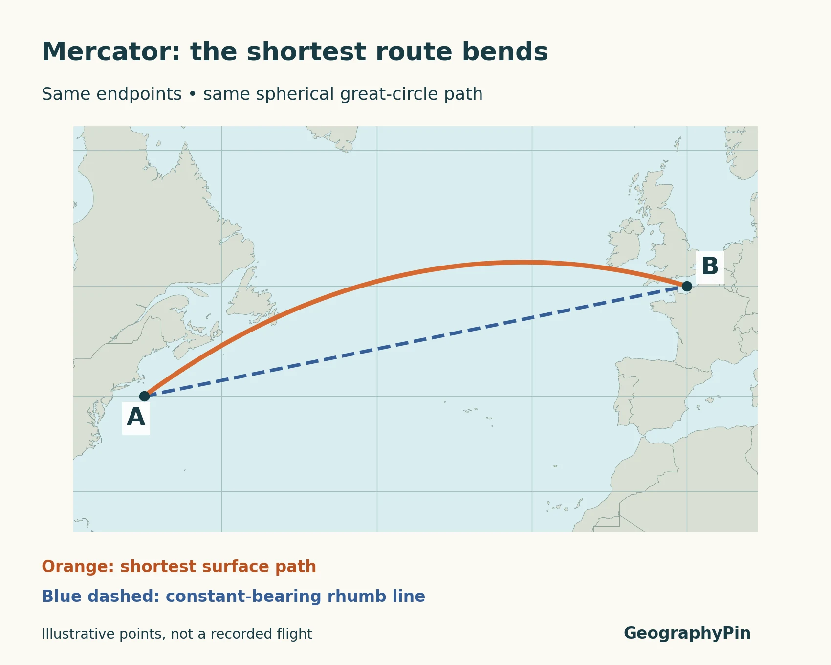
On a Mercator map, a line that keeps the same bearing relative to true north appears straight. That route is called a rhumb line. It is a useful navigational property, but a constant bearing and the shortest surface route are different requirements.
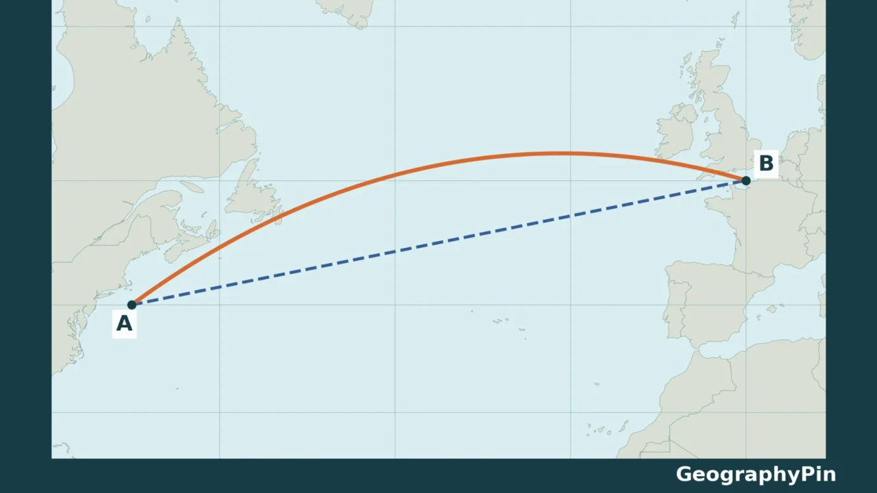
In the first illustration, the orange great-circle path bows north of the dashed blue rhumb line. The endpoints are identical. The orange path has not acquired extra distance just because the page makes it look curved.
Gnomonic makes great circles straight
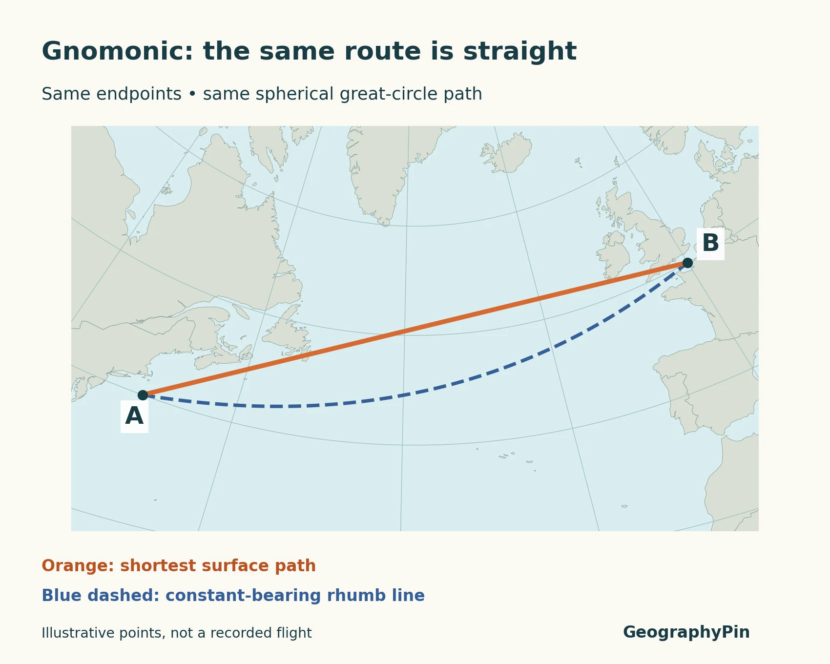
Now change the projection, not the journey. A spherical gnomonic map displays great circles as straight lines. The same orange route becomes straight, while the blue rhumb line bends. This reversal is the simplest way to see why the shape of a line on one flat map cannot settle its distance on Earth.
No projection preserves every useful property everywhere. Gnomonic is helpful for this route comparison, not a universal replacement for other maps. For a different trade-off, our Equal Earth comparison explains why preserving area is a separate goal from preserving bearings or route appearance.
3. A worked example: curved versus straight
The example uses deliberately simple coordinates: A is at 40°N, 70°W and B at 50°N, 0°. They are mathematical endpoints in the North Atlantic region, not claims about an airline service. Both paths are calculated on the same sphere with a radius of 3,959 miles (6,371 kilometers).
| Path | Surface distance, rounded | Mercator appearance |
|---|---|---|
| Shorter great-circle arc | 3,361 miles (5,408 km) | Curved |
| Rhumb line | 3,476 miles (5,594 km) | Straight |
Using the unrounded distances, the rhumb line is about 116 miles (186 km) longer in this example. That difference comes from the two defined paths on the sphere, not from measuring pixels or applying a ruler to the map. The percentage difference would change with the endpoints; it is not a general saving for transatlantic flights.
Coordinates, Earth model and route definition all matter when comparing answers from distance calculators. A calculator using real airport reference points and an ellipsoid can legitimately differ from this teaching example. A flight tracker may report the distance actually flown, which answers another question again.
4. Why a real flight may take another route
Shortest distance is not the same as the best flight plan
A great-circle diagram answers a geometry question. It does not decide which route an aircraft should fly. NATS, the UK air-navigation service provider, describes flight planning within a structured airspace system and explains that flexible routes still use defined entry and exit points.
Winds and weather can change the most efficient trajectory. A route with a favorable wind can make more operational sense than simply minimizing distance over the ground. Airspace structure also matters: freedom to choose an efficient route does not mean permission to fly anywhere. The orange line in our illustration includes none of those operational constraints.
This is why a map alone cannot establish that a particular aircraft made an unnecessary detour. To explain a specific flight, you would need its actual track and the relevant conditions and constraints. A smooth connecting curve between two cities may be a schematic route illustration rather than evidence of where a plane flew.
Keep three questions separate: What is the shortest geometric surface route? What route was planned under the applicable conditions? What track did the aircraft actually follow? They may be similar, but they are not interchangeable measurements.
5. How to read a flight-path map
First check what the line represents. A route network, a calculated shortest path and a recorded flight track can all look similar at a glance. The legend and caption should identify which one you are seeing.
Next check the projection. On Mercator, a straight segment suggests a rhumb line if it is being interpreted as a continuous geographic path. On a spherical gnomonic map, a straight segment represents a great-circle arc. On another projection, do not assume either rule applies.
Finally, check the distance definition before comparing numbers. Surface distance between endpoints, scheduled route distance and distance actually flown are not the same. A map is useful evidence only when its labels explain its method. Our two illustrations deliberately preserve the endpoints and paths while changing just the projection.
Frequently Asked Questions
Does every shortest route look curved on Mercator?
No. The equator and meridians are great-circle paths that appear straight on Mercator. Many other great-circle arcs appear curved. The route and projection together determine the appearance.
Does a northward curve mean the plane goes over the North Pole?
No. An arc can reach a higher latitude than its endpoints without reaching the pole. In our example it bends north across the Atlantic, but nowhere approaches the North Pole. A curved line by itself is not evidence of a polar flight.
What Did We Learn Today?
The same surface route can look curved on one map and straight on another. Great circles describe spherical shortest paths, while Mercator’s straight lines describe constant bearings. Our calculated example separates those paths without pretending to be an airline record. For a real journey, route geometry is only the starting point: conditions and airspace requirements also shape the plan.
Sources & Data Notes
GeographyPin calculated the illustrated paths on a sphere of radius 3,959 miles (6,371 km) using the stated hypothetical coordinates. The great-circle path was sampled with PROJ’s geodesic routines; the rhumb-line distance uses spherical navigation equations. Distances are rounded independently to whole miles and kilometers. Original maps use public-domain Natural Earth 1:50 million outlines, with Mercator and spherical gnomonic projections. They do not show actual airline routes, weather, airspace permissions or current territorial control.
- PROJ: Geodesic calculations — spherical and ellipsoidal shortest paths.
- PROJ: Gnomonic projection — spherical straight-line property and projection limits.
- NASA Planetary Data System: Map projection definitions — Mercator and gnomonic properties, drawing on USGS projection references.
- NATS: Airspace modernisation — route structure, weather and winds.
- Natural Earth: Terms of use — public-domain basemap data.