Vietnam’s long outline can make it look like a single coastal corridor. Its geography is better understood through the contrast between northern mountains and the Red River Delta, a narrow central belt, and the southern Mekong Delta. Recent administrative changes add another reason to keep physical regions separate from province and city boundaries.
Vietnam is a Southeast Asian country bordering China, Laos and Cambodia. Western and northern uplands contrast with coastal lowlands, the Red River Delta in the north and the Mekong Delta in the south. Its narrow central region links these broader ends, while rivers connect its landscapes with upstream areas outside the country.
How to use this article: Compare the northern landscapes, follow the Mekong’s branching channels, or check how administrative boundaries changed.
1. Where is Vietnam?
Vietnam lies on the eastern side of mainland Southeast Asia. China borders it to the north; Laos and Cambodia lie along its western side. The South China Sea, called the East Sea or Biển Đông in Vietnam, lies off its eastern and southern coasts. Its southwestern coast faces the Gulf of Thailand. Hanoi is the national capital, in the north rather than at the center of the country.
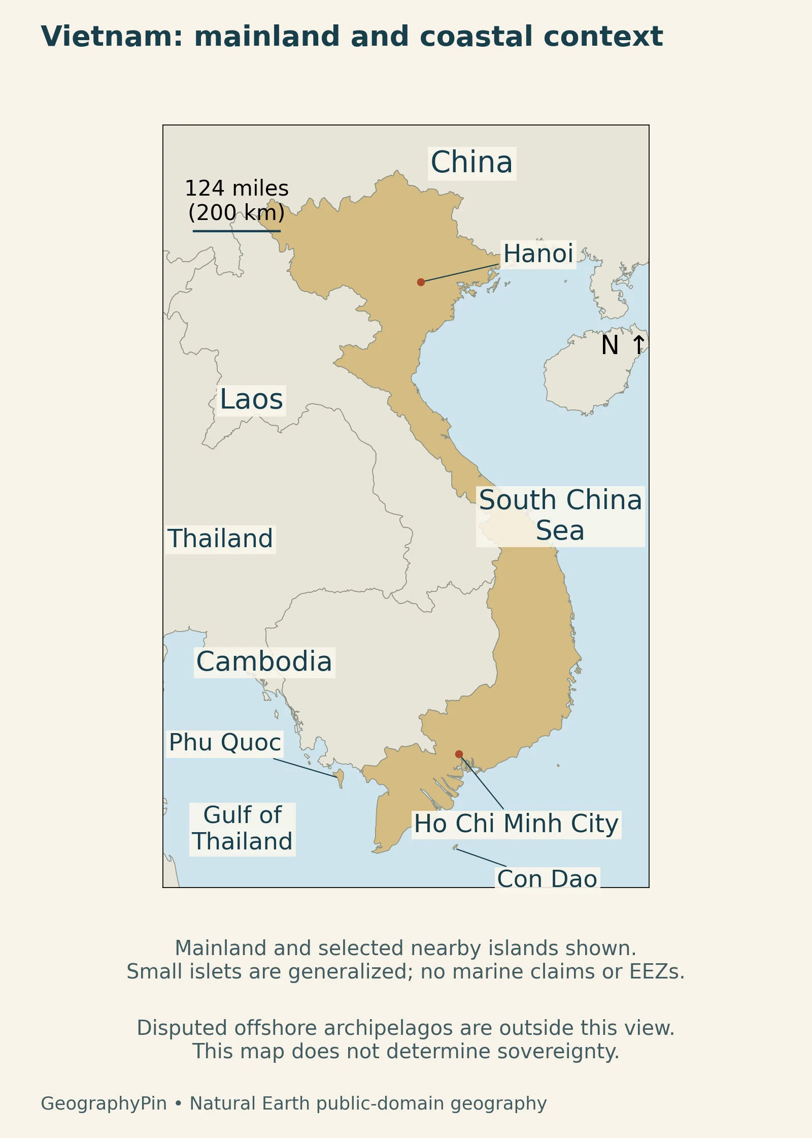
A narrow middle connects two broader ends
Western uplands and coastal plains create contrasting environments along the country’s length.
The government’s physical-geography overview describes its elongated shape and concentration of mountains in the west and northwest.
2. Country facts and the 2025 boundary changes
| Topic | Fact | Scope |
|---|---|---|
| Capital | Hanoi | National capital |
| Area | About 128,000 sq mi (331,000 km²) | Rounded geographic area in the foreign ministry’s country overview |
| Population | 102.3 million | NSO estimated annual average for 2025 |
| Language | Vietnamese | National language |
| Currency | Vietnamese dong (VND) | National currency |
| Provincial-level units | 34: 28 provinces and 6 cities | Structure established in the 2025 reorganization |
The National Statistics Office’s January 2026 release reports an estimated average population for 2025. That is a whole-year average, not a count taken on December 31. The foreign ministry’s overview supplies the basic capital, language and currency information.
Physical regions are not the new administrative units
The 2025 reorganization reduced the number of provincial-level units from 63 to 34. The NSO yearbook introduction explains that the new structure took effect in operation from July 2025 and that its tables include both old and new geographic groupings. Physical regions extend across these administrative boundaries.
This distinction matters when comparing regional population, area or economic statistics. A figure for an older province may refer to only part of a newer unit with the same name.
3. Northern mountains and the Red River Delta
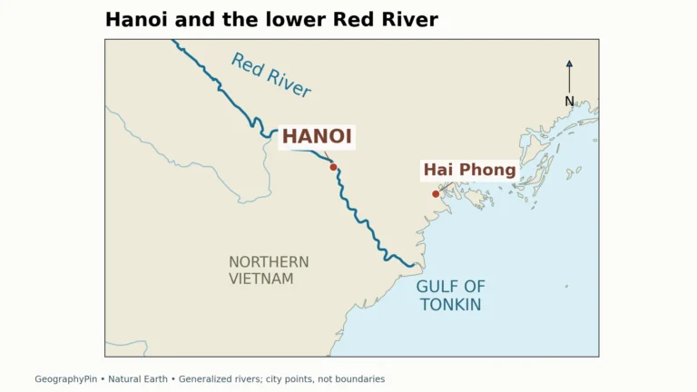
Northern mountains contrast with the lower Red River
Northern Vietnam contains rugged uplands as well as the lowland setting around Hanoi and the Red River Delta. Dong Van provides a particularly clear mountain example. UNESCO’s geopark description identifies limestone peaks, deep canyons and extensive karst features, alongside other rock types. The landscape is not simply an elevated version of the delta plain.
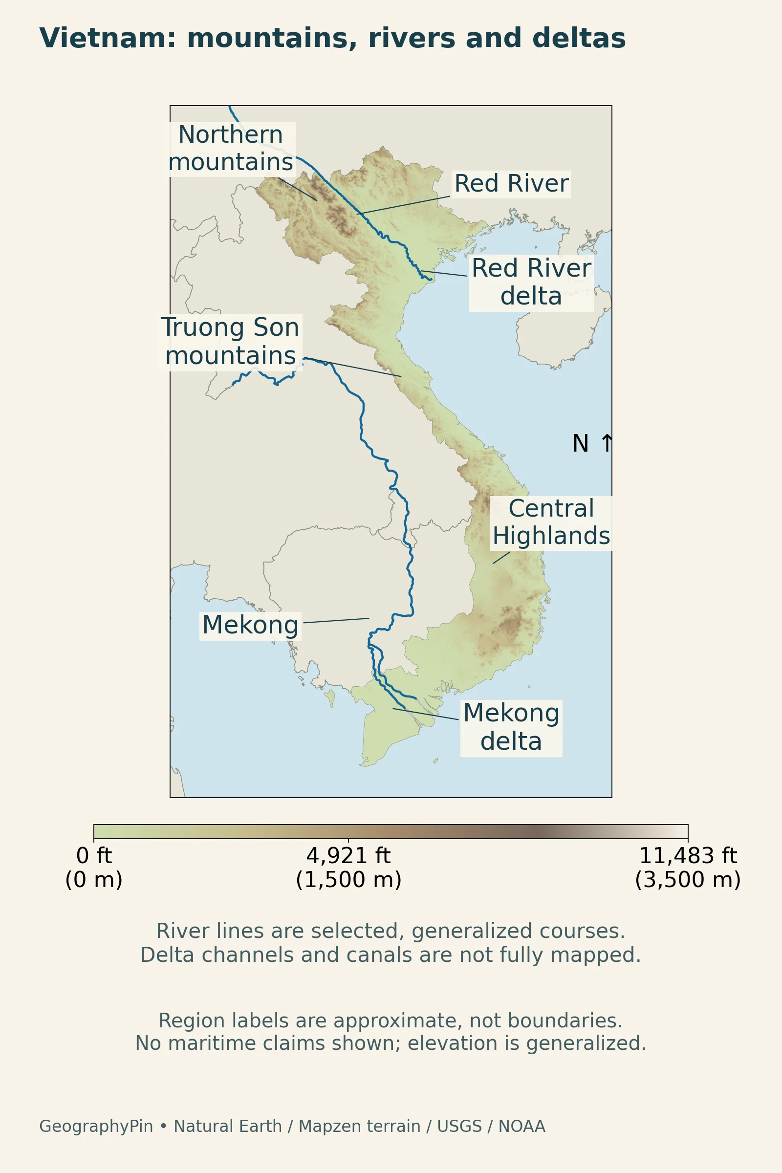
The Red River links an upstream landscape with the lower country around Hanoi and the Gulf of Tonkin. The capital is inland. Its wider municipality also includes uplands, so describing the whole administrative area as flat would be misleading. See the separate Hanoi geography article for the city’s river, lakes and municipal setting.
The delta reaches a changing coastal environment
At the coast, the Red River Delta Biosphere Reserve protects estuarine wetlands, mangroves, mudflats and seagrass beds. River-borne material meets marine processes here; tidal channels redistribute water and sediment, while mangrove roots trap alluvium.
Rice farming, aquaculture and small-scale fishing occur in the reserve’s coastal communities. The reserve is one protected part of the wider delta, not the delta’s entire territory.
4. The narrow central coast and mountain spine
Mountains and the sea shape central Vietnam
Central Vietnam connects the broader northern and southern regions through a comparatively narrow belt. The Annamite Mountains, known in Vietnamese as Trường Sơn, form a major upland system toward the western side. Coastal plains and river mouths occupy lower ground to the east. The result is a sequence of local coastal and mountain settings rather than one uninterrupted broad delta.
Phong Nha-Ke Bang illustrates the geological complexity of this upland region. UNESCO’s description of the transboundary property places it at the meeting of the Annamite Range and a major limestone belt, across the Vietnam–Laos border with Hin Nam No. Limestone is interbedded with other rocks, and caves, sinkholes and underground rivers form part of the landscape.
In karst terrain, water can flow through caves and underground passages as well as surface channels. These connections help explain why visible streams alone do not represent the full drainage system.
Rainfall seasons change from north to south
Research by Vietnamese forecasting-center scientists distinguishes regional rainfall patterns shaped by latitude and relief. The north has a cooler winter regime than the southern lowlands, while central coastal rainfall often concentrates later in the year than the summer monsoon rains of the south and Central Highlands. Elevation and exposure create further local differences.
These differences matter when interpreting the map: a central coastal city, an inland highland settlement and the southern delta do not share one uniform rainy season.
5. The Mekong Delta and its water connections
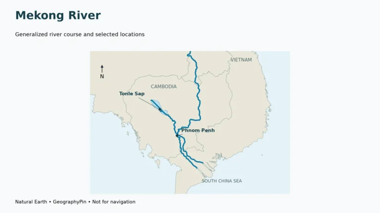
The southern delta is connected to an international basin
The Mekong Delta is the downstream end of a river system extending far beyond Vietnam. The Mekong River Commission describes the Bassac branching from the Mekong near Phnom Penh in Cambodia. Downstream, these main channels divide into smaller watercourses across the delta plain. They are distributaries, carrying water away from a main channel, rather than tributaries joining it.
This connection makes the national border an incomplete boundary for understanding water in southern Vietnam. Upstream river conditions and the downstream sea both matter. For the wider river course and basin, use the separate Mekong River article; the focus here is its relationship with Vietnam’s southern lowlands.
Sediment, sinking land and saltwater interact
A delta is not a permanently fixed plain. MRC sediment monitoring explains why sediment movement matters to channels, floodplains and coastal lowlands. Reservoirs can trap material upstream, while sand extraction removes channel sediment. Changes in land use and river flow also affect how material moves through the system.
Water beneath the land matters as well. Research on groundwater extraction shows how pumping can lower groundwater levels and compact the aquifer system, allowing the land surface to sink. This process adds to the challenges faced by a low delta without requiring the sea itself to rise by the same amount.
During the dry season, research on Mekong salinity shows that saltwater penetration depends on the balance between freshwater flow, tides and coastal water levels. Subsidence and deeper channels can change that balance alongside sea-level rise. Their relative influence varies across the delta.
6. People, cities and regional identity
Hanoi and Ho Chi Minh City need different geographic scales
Hanoi’s position in the lower Red River region contrasts with Ho Chi Minh City’s southern setting. Neither city should be reduced to a dot when discussing its population or economy: a central urban area, an administrative municipality and a wider economic region describe different territories.
The Ho Chi Minh City investment agency describes the July 2025 merger of the former city with Binh Duong and Ba Ria–Vung Tau. The enlarged municipality brings together the previous urban center, industrial areas and coastal port infrastructure. An older city population or area consequently does not describe the same boundary as the new municipality.
Vietnamese is the national language, but cultural geography varies locally. The Dong Van geopark account, for example, describes communities with distinct languages, crafts and traditions. A national language label is useful for a fact table; it is not a complete description of the communities living in every mountain valley or delta settlement.
7. Economy in its geographic setting
Urban markets, manufacturing and delta livelihoods
The OECD’s review of foreign investment identifies Hanoi and Ho Chi Minh City as important centers for investment-related employment, reflecting access to markets and infrastructure. Its regional analysis highlights the Red River Delta and the southeastern region, while also noting expansion outside major urban centers.
Transport connections help link industrial locations with customers and ports, while infrastructure and the business environment affect how those connections work. Relief matters, but it cannot explain regional development by itself. A mountain region, a port-linked industrial corridor and a delta farming community face different opportunities and constraints.
Along the Red River coast, fisheries, aquaculture and farming link livelihoods to water, sediment and coastal ecosystems. These activities complement the industrial and service networks of larger urban regions.
What Did We Learn Today?
Vietnam’s outline connects several different landscapes rather than one uniform coastal plain. Northern karst uplands, the Red River’s coastal wetlands, the Annamite mountain belt and the Mekong’s branching channels each explain a different part of the country. Rivers cross political boundaries, and physical regions do not change when administrative units merge. Dates and geographic scope are therefore essential when comparing places and statistics.
Sources & Data Notes
Population is NSO’s estimated annual average for 2025. Administrative-unit counts reflect the 2025 reorganization; older regional tables may use previous boundaries. Protected-area statistics are not treated as totals for entire physical regions. Older government geography material supports stable location and relief descriptions only, not current population or administrative figures.
- Vietnam Ministry of Foreign Affairs: country information
- National Statistics Office: 2025 population estimate
- Government portal: 2025 provincial-level reorganization
- National Statistics Office: 2025 yearbook and changed regional boundaries
- UNESCO: Dong Van Karst Plateau
- UNESCO: Red River Delta Biosphere Reserve
- UNESCO: Phong Nha-Ke Bang and Hin Nam No national parks
- Government portal: physical-geography overview
- Mekong River Commission: geographic regions
- Ho Chi Minh City investment agency: the expanded city
- OECD: foreign-investment employment and regional patterns
- Duc and colleagues, 2025: regional rainfall regimes in Vietnam
- Mekong River Commission: sediment monitoring and delta sensitivity
- Minderhoud and colleagues, 2017: groundwater extraction and subsidence
- Eslami and colleagues, 2021: compound drivers of delta salinity
Original maps: GeographyPin, using Natural Earth public-domain geography and rivers. Terrain: Mapzen, using SRTM and GMTED2010 data courtesy of the U.S. Geological Survey and ETOPO1 data courtesy of NOAA. The map focuses on the mainland and selected nearby islands, not an exhaustive territorial or maritime-claims inventory. Actual elevation data and generalized river courses are used; delta-channel networks are incomplete.
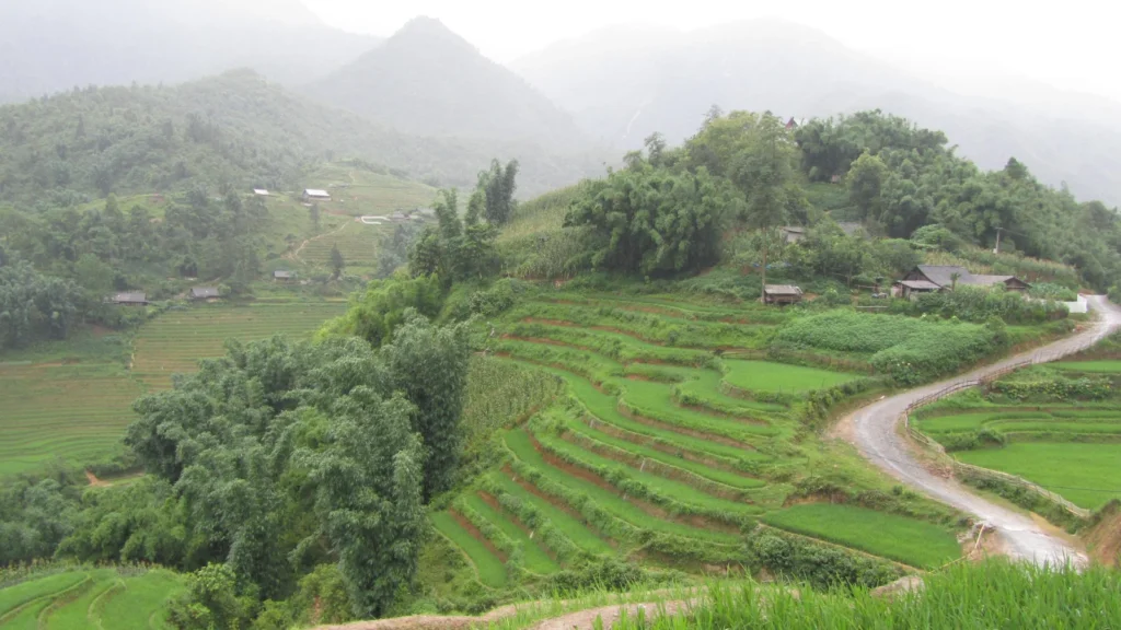
Featured photograph: terraced rice fields in Vietnam, July 5, 2014, Ali Mohammadi, distributed via imaggeo.egu.eu, CC BY 3.0. Cropped and resized; no added watermark. Delta research supports physical mechanisms, not a current forecast or an assertion that historical subsidence rates apply uniformly today.