Laos is landlocked, but its geography is organized around connections: rivers flowing between countries, valleys threading through mountains, and transport corridors crossing borders. Its broad country outline is only the starting point. The contrast between uplands and the Mekong corridor explains much more about where people live and work.
Laos, officially the Lao People’s Democratic Republic (Lao PDR), lies in mainland Southeast Asia and has no coastline. Vientiane is its capital. The Mekong connects the country with its neighbors, while northern mountains, the eastern Annamite Range and southern plateaus create distinct landscapes. River connections do not mean an uninterrupted navigable route to the sea.
How to use this article: Explore Mekong connections, compare physical regions, explore seasonal climate, or check population scope.
1. Locate Laos and Follow the Mekong
Five neighbors, no sea coast
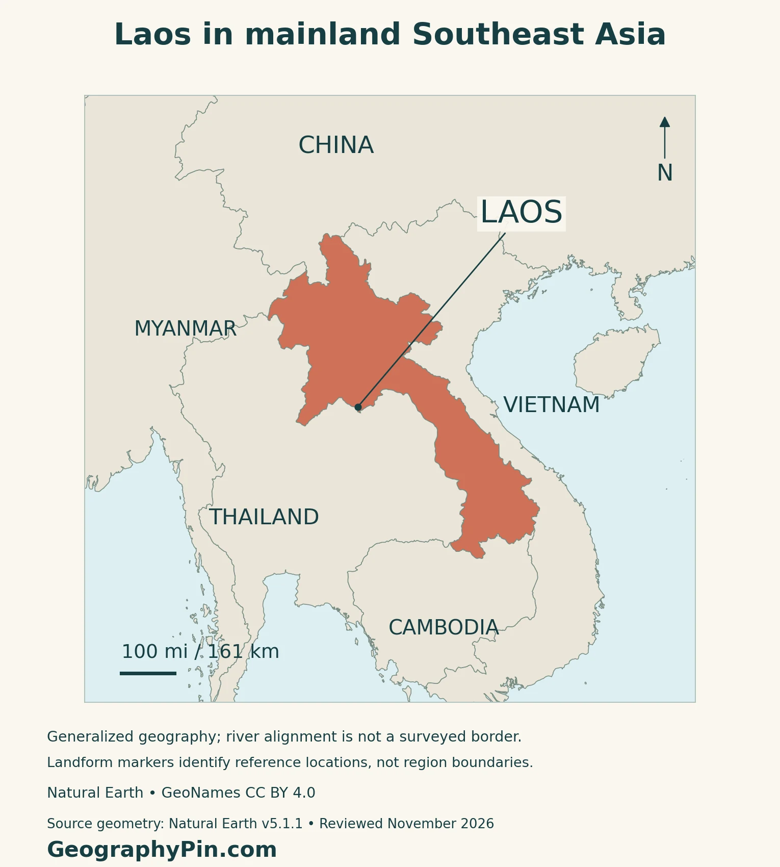
Laos borders China to the north, Myanmar to the northwest, Thailand to the west, Cambodia to the south and Vietnam to the east. Its northern part is relatively broad; farther south, the country extends as a narrower strip between Thailand and Vietnam before widening around its southern provinces.
The Mekong forms parts of the western international boundary, but it also runs inside Laos. The river and the national border are therefore not interchangeable lines. Follow the actual channel on the map rather than assuming that all land on one side belongs to a single country.
A shared basin is different from a sea-access route
The Mekong and its tributaries link Lao catchments with a larger international drainage system. Northern tributaries such as the Nam Ou and Nam Khan join the main river, carrying water from mountain landscapes into the basin network.
That connection supports river settlements and regional exchange, but navigation has limits. Khone Falls in southern Laos interrupts through-vessel passage, and rapids, shallow sections and seasonal low water constrain other reaches. Laos remains landlocked even though its rivers ultimately connect with the sea.
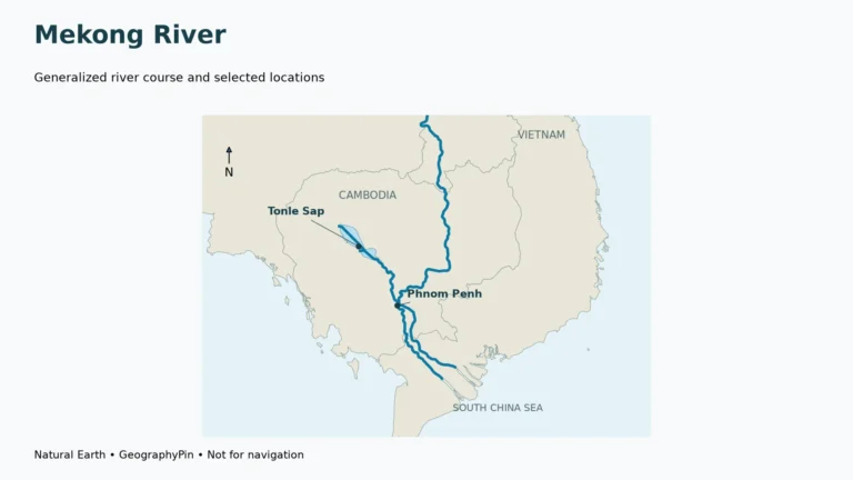
For the river’s full course and wider basin, use the separate Mekong River map and guide. Here, the focus is what the river means for Laos as a country.
2. Mountains, Plains and the Bolaven Plateau
Four useful landscape settings
Laos is not simply a flat strip beside a large river. Rugged uplands dominate much of the north, the Annamite mountain system follows the eastern side, and lower plains and elevated plateaus create important contrasts within the country.
| Setting | What to recognize | Why it matters |
|---|---|---|
| Northern uplands | Ridges, narrow valleys and scattered upland basins | Routes and settlements follow usable passages through rugged terrain |
| Annamite Range | Mountain belt along the eastern side | A major divide between Mekong drainage and rivers flowing toward Vietnam’s coast |
| Mekong-side plains | Lower ground around Vientiane and farther south | More extensive space for settlement and lowland farming |
| Bolaven Plateau | Elevated landscape in southern Laos | Volcanic soils and cooler growing conditions support a distinctive coffee-growing region |
The Annamites organize drainage, not just scenery
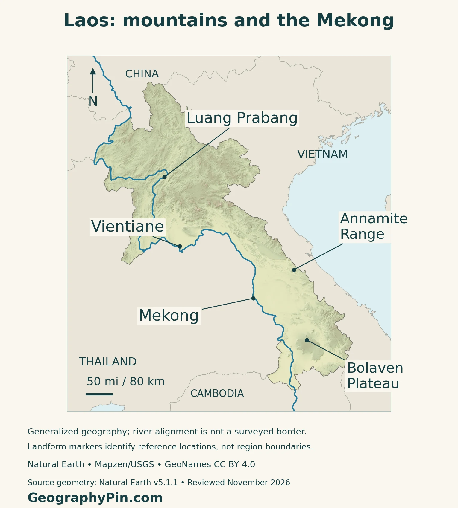
The Annamite Chain separates much of the Mekong-facing drainage to the west from drainage toward the South China Sea to the east. Tributary valleys cut into this mountainous zone, so a continuous-looking ridge belt on a regional map contains many local corridors.
The physical map uses real elevation data to show relief. Its mountain and plateau labels are geographic reference points, not surveyed boundaries of uniform regions. A pale valley or dark ridge should not be read as an administrative border.
Luang Prabang shows how rivers shape a town
Luang Prabang occupies a peninsula between the Mekong and Nam Khan in the mountainous north. The confluence and surrounding hills give it a very different setting from a broad lowland urban plain.
UNESCO recognizes the town’s combination of Lao urban traditions and colonial-period architecture. Its former royal role should not cause confusion with the present national capital, Vientiane.
3. Monsoon Seasons and Working Landscapes
Rainfall has a strong seasonal rhythm
The World Bank–ADB 2021 climate profile describes a rainy season from roughly May to mid-October and a drier period from mid-October to April, using a 1991–2020 climatological baseline. Mountains and plateaus are generally cooler than the lower plains.
These are broad climatic patterns, not fixed opening and closing dates for rain. Elevation and local terrain produce differences within the same season; a national average cannot describe every valley or upland farm.
Farmers must manage both too much and too little water
Laos’s agriculture and forestry disaster-management plan documents how floods, droughts and storms affect crops, livestock and irrigation. Water can support production during one part of the year and damage fields or infrastructure during another.
That makes the timing and accessibility of water as important as annual rainfall. A field beside a river is not automatically protected from drought, and a productive lowland plain can still be exposed to flooding.
Bolaven coffee reflects an upland environment
The Bolaven Plateau offers a different agricultural setting from the lowland plains. FAO’s technical coffee manual describes volcanic red soils and favorable conditions at higher elevations, with production involving both smallholders and larger estates.
Both Arabica and Robusta coffee have been grown there. Elevation alone does not determine the product: plant variety, site conditions, farm management and processing also affect quality.
Mountain routes can be vulnerable even away from the main river
River flooding, flash flooding and landslides pose different hazards. The climate-risk profile highlights damage to roads and other infrastructure, which can hamper response and recovery. Low rainfall also creates drought exposure.
These risks are spatially uneven. A national physical map helps explain slopes and drainage, but it cannot identify a safe route during a storm or replace local warnings.
4. Transport, Electricity and Regional Connections
Landlocked does not mean disconnected
The Laos–China Railway began operating in December 2021. Its Lao corridor links Vientiane with Boten at the Chinese border, giving the country a north–south connection that complements roads and river transport.
The World Bank’s rail-connectivity study emphasizes that a railway alone is not enough. Roads to production areas, cargo handling, logistics services and efficient border procedures determine how widely the benefits reach.
Electricity exports and domestic reliability are different measures
Hydropower connects Laos’s river geography with regional energy markets. The U.S. International Trade Administration’s January 2026 assessment describes a sector dominated by hydropower, but also notes that substantial electricity exports and seasonal electricity imports coexisted in 2024.
Transmission and distribution constraints help explain that apparent contradiction. Installed generating capacity, electricity actually produced, power traded across borders and reliable household supply measure different things. One cannot be substituted for another.
Dam decisions have effects beyond the generating site
The Mekong River Commission identifies changes to flow timing, sediment movement and fish migration among the consequences of hydropower development. Reservoirs can also affect settlements and livelihoods.
Because the basin crosses national borders, project assessment must consider downstream effects as well as electricity benefits. A dam is therefore both an energy installation and an intervention in a connected river system.
The economy is broader than a hydropower nickname
The World Bank’s June 2026 economic assessment identifies tourism, transport and exports of electricity and electrical equipment among the drivers of growth in 2025. It also highlights debt pressures and exposure to external shocks.
This is why a country profile should not reduce Laos to the label “battery of Southeast Asia.” Its geographic position supports several activities, while infrastructure, public finances and conditions in neighboring markets influence the results.
5. Country Facts with Dates and Scope
Laos and Lao PDR refer to the same country
| Item | Reference |
|---|---|
| Capital | Vientiane Capital |
| Population | About 7.24 million: 2025 census, post-enumeration-adjusted resident estimate |
| Surface area | About 91,429 square miles (236,800 square kilometers); UN reference year 2023 |
| Official language | Lao |
| Currency | Lao kip (LAK) |
| Government | Republic led by the Lao People’s Revolutionary Party |
| Top-level administration | 17 provinces plus Vientiane Capital |
Why the census reports more than one population total
The census reference moment was midnight at the start of November 3, 2025. It used usual residence, rather than simply counting everyone physically present on that date. The adjusted estimate covers residents across citizenships.
The report distinguishes 6.74 million enumerated residents from the 7.24 million estimate adjusted through a post-enumeration survey. It recommends the latter for demographic and planning denominators. A separate 7.55 million total adds emigrants and must not be substituted for the resident population.
The capital and Vientiane Province are different units
Vientiane Capital is separate from Vientiane Province. The national capital’s name, its administrative territory and the neighboring province should not be treated as identical geographic areas.
Laos is also implementing a sub-district administrative reform under its amended 2025 Constitution. The stable top-level summary is 17 provinces plus the capital; a changing count of newly organized sub-districts would need its own reference date.
Read language and area labels literally
Lao is the official language under the amended Constitution, which does not imply that all residents share one mother tongue. The area above is the UN’s surface-area measure, not a separately verified land-only total or a measurement taken from this article’s generalized country outline.
For regional context, use the Southeast Asia countries map and the Asia countries and capitals list.
What Did We Learn Today?
Laos combines a landlocked position with strong regional connections. The Mekong links settlements and catchments, while mountains and plateaus create distinct farming and transport environments. Luang Prabang’s confluence setting differs from Vientiane’s capital role. Railways and electricity trade add other cross-border connections, but neither removes the importance of terrain, seasonal water or clearly defined national statistics.
Sources & Data Notes
Population refers to the 2025 census’s post-enumeration-adjusted resident estimate, released in October 2026; it is not the raw enumeration or a 2026 projection. Surface area is not a dry-land-only measure. The constitutional source is a reproduced English translation of the 2025 amendment. Older physical and coffee accounts support landscape relationships, not current production shares. Climate normals describe a historical period, not a forecast. Rail-study projections are not treated as realized outcomes.
- Lao National Assembly: archived national geography, used for stable landscape orientation
- MRC: 2014 crop study, physical-region discussion
- MRC: Mekong geography and tributary connections
- MRC archived technical account: river navigation constraints
- UNESCO: Town of Luang Prabang, setting and historical capital roles
- World Bank–ADB: 2021 climate-risk profile, 1991–2020 baseline
- Lao Ministry of Agriculture and Forestry: disaster-risk plan 2022–2025, via FAO
- FAO: Arabica coffee manual, site and farming conditions
- Chinese government portal: July 2026 report citing railway operator, opening date
- World Bank: 2020 rail-connectivity study and complementary infrastructure
- U.S. International Trade Administration: energy-sector guide, January 2026
- MRC: hydropower benefits and river-system impacts
- World Bank: June 2026 Economic Monitor, dated economic context
- Lao Statistics Bureau: 2025 Population and Housing Census main report, released October 2026
- UN Statistics Division: surface area and currency; its population projection is not used
- National Assembly: Constitution amended March 2025, English translation reproduced by BritCham Laos
- KPL: July 2026 official interview on administrative reform
Map method: Original GeographyPin cartography uses public-domain Natural Earth v5.1.1 country and river geometry, with actual Mapzen/USGS elevation data. GeoNames reference points are credited under CC BY 4.0. Both northern and southern source Mekong records are retained; blue river linework is not a surveyed border or a navigation chart. Generalized boundaries do not establish precise channel ownership or current demarcation status. The Annamite and Bolaven markers identify reference locations, not the full extent of either landform; no climate-zone or heritage-property polygons are inferred. The feature is a decorative flag-filled outline with a complete circular white disc and a separate intact national flag.