The neat time-zone diagram in a textbook starts with equal strips of longitude. A real map follows the places where people live, work and cross borders, which makes its lines much less regular.
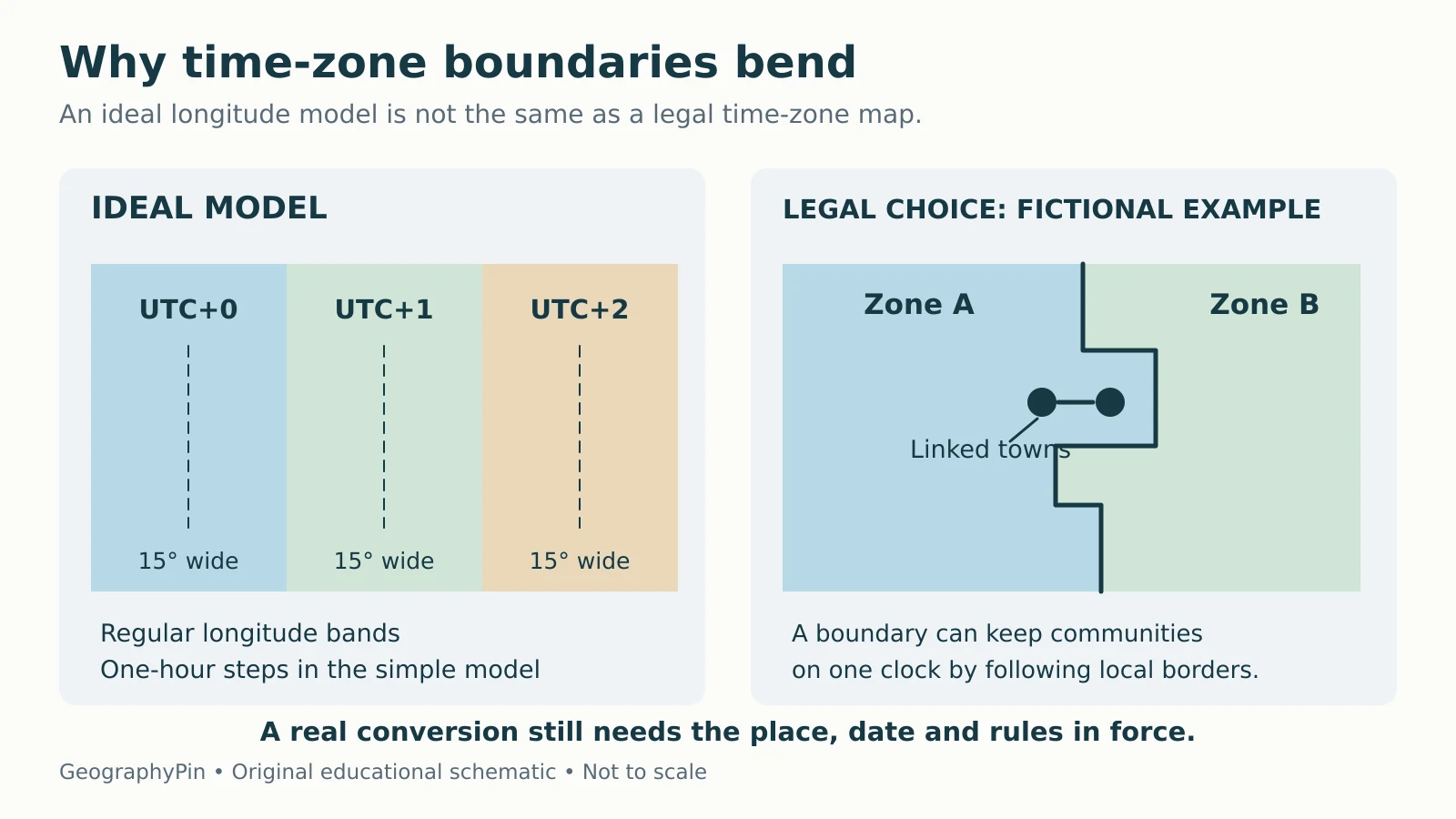
Time zone borders are not straight because governments choose civil time for communities, transport and administration rather than assign a new clock time at every meridian. The ideal 15-degree bands explain the link between longitude and solar time. Actual boundaries often follow national, state, county or natural boundaries and may change through legal decisions.
How to use this article: You can understand the ideal model, follow a boundary decision, or separate boundary and clock changes.
The 15-Degree Model Is a Starting Point
Longitude explains the ideal spacing
Over an average solar day, Earth turns through 360° relative to the Sun in about 24 hours. Dividing 360 by 24 gives 15° per hour. In an idealized scheme, each one-hour time zone would therefore be centered on a meridian 15° from the next.
That arithmetic describes the relationship between longitude and mean solar time. It does not oblige a government to put a border on the edge of every theoretical strip. NIST’s Local Time FAQs uses the 15-degree model as the basis, then explains why real boundaries diverge from it.
One degree of longitude corresponds to four minutes of mean solar time. Two places 6° apart therefore differ by 24 minutes in that ideal solar relationship. They can still use exactly the same legal clock time. Longitude remains different even when the clocks agree.

The latitude and longitude guide explains the coordinate grid behind these meridians.
Shared Schedules Often Matter More Than Straight Lines
Local solar time changes continuously with longitude. A transport timetable or regional working day is easier to coordinate when neighboring places share a common reference. Standard time trades some local solar alignment for that consistency.
The U.S. Department of Transportation describes how U.S. and Canadian railroads adopted a four-zone operating system in 1883 to reduce confusion among many local times. Federal oversight of U.S. time-zone boundaries followed in 1918. This history helps explain why transport and commerce remain part of the boundary question.
A perfectly straight line could divide a community from the places it depends on for work, schools, health care or connections to larger transport networks. Following an existing administrative boundary can make the rule easier to explain and administer. A river or other recognizable feature can also form part of a legal boundary.
There is no requirement that all countries use the same balance. A country may prefer a common national clock, while another uses several zones. The separate question of which countries have the most time zones concerns counting, not why a particular boundary bends.
A U.S. Example: What Officials Consider
The convenience-of-commerce test
In the United States, the Department of Transportation’s time-zone change procedure identifies the convenience of commerce as the principal standard. Its considerations include commuting, supplies, transport, broadcasting, schools, health care and shopping.
Imagine a fictional county on the edge of two zones. Most residents commute to a city in the western zone, and the nearest major airport uses that same time. Keeping the county on the eastern clock would mean repeated time conversions in everyday routines. Those facts could support a request to move the boundary, but they would not automatically change it.
A legal decision is still needed. Under the federal process described by DOT, a change can be made by statute or by regulation. A locality’s preference, a mapmaker’s choice or a phone setting does not itself redraw the official boundary.
This example also explains the zigzag. A decision may move one county while leaving its neighbors unchanged. The resulting line follows the affected territory rather than a single meridian. Other countries have their own institutions and procedures; the U.S. process is not a worldwide rule.
A Boundary Change Is Not Every Clock Change
Ask what the decision actually changes
Two maps can show different colors without a physical or administrative boundary moving. The legend may use different dates or display a different kind of time information. Separate changes to the territory covered by a rule from changes to the rule itself.
| Change | What it affects | What to verify |
|---|---|---|
| An area joins another standard time zone | The legal extent of the zones changes | Affected territory and effective date |
| Daylight saving begins or ends | Clocks shift under a seasonal rule | Date and jurisdictions observing the rule |
| A jurisdiction changes its standard UTC offset | The clock rule changes; its outer boundary need not move | New offset and effective date |
| A time-zone database is updated | Software receives revised or corrected rules | Which records and dates changed |
For example, two neighboring areas might share an offset in winter but differ in summer because only one observes daylight saving. A dated offset map would change, even if their standard-zone boundaries did not.
A software update is not itself a government decision. It may implement a newly announced rule, correct an older record or add better historical information. The IANA documentation describes the database as a record of civil-time histories and predicted future rules.
That distinction matters near an irregular line. Establish which territory the legal rule covers first, then apply the correct clock rule for the required date.
The Date Line Is a Different Kind of Boundary
The antimeridian is the 180° longitude line. The International Date Line roughly follows that part of the Pacific, but its practical course bends around political geography. NOAA’s longitude explanation distinguishes the geographic meridian from date and time boundaries dependent on local laws.
Crossing the date line changes the calendar date associated with local time. It is not simply another ordinary one-hour zone border. A map that substitutes a perfectly straight 180° line for the actual date convention can place an island on the wrong calendar day.
Read the legend before treating every line on a time map as the same kind of boundary. A meridian, a standard-zone border and a calendar-date boundary answer different questions.
How to Read a Time-Zone Map Reliably
First check what the map displays: standard offsets, offsets on a particular date, or named time-zone regions. Those are not interchangeable. Then look for its publication date, treatment of daylight saving and handling of small territories or boundary exceptions.
The IANA time-zone database documentation explains that governments control time rules and may change them with little notice. Software uses updated rules to calculate local time; a printed map can become out of date even though the underlying longitude grid never changes.
An offset such as UTC−05:00 gives a difference from UTC. A time-zone identifier such as America/New_York represents rules that vary with date. Neither a location’s longitude nor a fixed offset alone captures that complete history.
- Use longitude to understand solar relationships, not to infer legal time.
- Check the named place rather than selecting the nearest colored strip.
- Read hour-and-minute offsets correctly.
- Include the date when converting an appointment or departure.
- Use current local rules for a location near a boundary.
The irregular map is a record of choices about shared schedules. Its bends are often the useful part: they show where those choices depart from the simple geometric model.
What Did We Learn Today?
The 15-degree model connects longitude with solar time, but legal decisions determine civil-time boundaries. Shared schedules, transport and administration can make a bent line more useful than a straight meridian. Distinguish a boundary change from a clock-rule change, read the map’s date and legend, and verify the applicable territory before converting local time.
Sources & Data Notes
The boundary explanation is evergreen. The county scenario and diagrams are fictional, not maps of current jurisdiction boundaries. The comparison table distinguishes types of changes rather than announcing a change in any named place. Recheck the current legal rule and effective date for an actual location.