Two names can make this corner of Southeast Asia harder to find than it needs to be. The Sulawesi Sea, also called the Celebes Sea, becomes much easier to understand once you recognize the islands around it and distinguish its deep basin from the region’s coastal reefs.
The Sulawesi Sea, or Celebes Sea, lies between Borneo, Sulawesi and the southern Philippines. Indonesia, Malaysia and the Philippines border its waters. It connects with neighboring seas through island passages and Makassar Strait. Its deep basin belongs to a wider region that includes both coastal habitats and open-ocean ecosystems.
How to use this article: Locate the surrounding islands, sort out names and countries, interpret the depth evidence, or explore life beyond the reefs.
1. Where the Sulawesi Sea lies
Read the islands before the country names
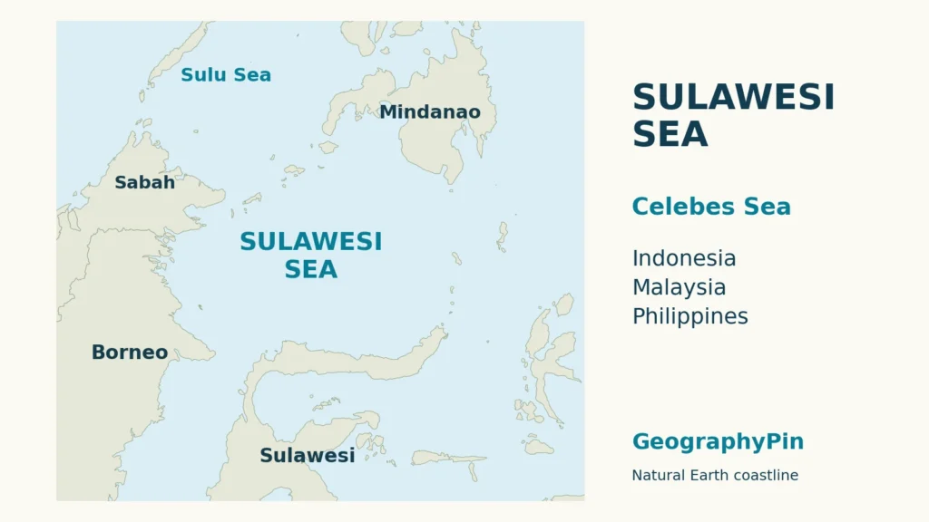
The Sulawesi Sea occupies the water between northeastern Borneo, northern Sulawesi and the southern Philippines. The Sulu Archipelago frames much of its northern side; the Sangihe island chain marks its eastern approach. On a wider map of the world’s oceans, look in Southeast Asia, among the islands separating the western Pacific from the Indonesian seas.
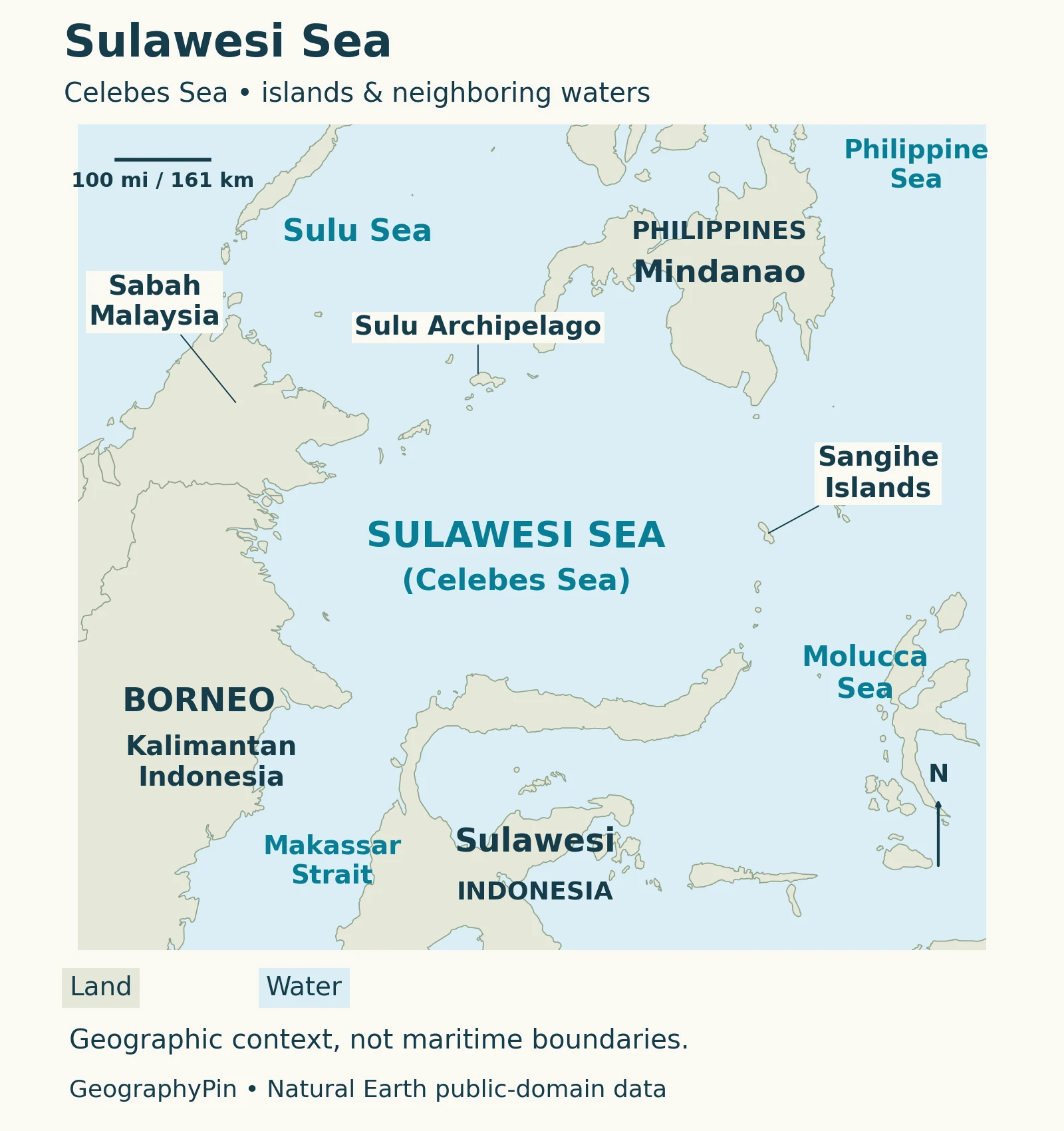
Start with Borneo on the left, then find Sulawesi below and Mindanao above. This three-island pattern makes the sea easier to recognize than a country label floating over open water. The island shapes are also more useful than a rectangular outline: the real margins follow coasts and island chains rather than the edges of the image.
The International Hydrographic Organization’s 1953 description uses coastal points and connecting lines to define the named sea. Those geographic limits are not a map of ownership. The image here emphasizes orientation and neighboring waters, not exclusive economic zones or disputed maritime claims.
2. Two names, three neighboring countries
Celebes and Sulawesi refer to the same sea
Sulawesi Sea and Celebes Sea are alternative names, not two adjacent basins. You will encounter both in scientific literature. The Coral Triangle Initiative explicitly pairs Celebes with Sulawesi in its regional assessment, while many Ocean Drilling Program papers use Celebes Sea.
| Country | Where to look on the map |
|---|---|
| Indonesia | Northern Sulawesi and the eastern side of Indonesian Borneo, or Kalimantan. |
| Malaysia | Sabah, on northeastern Borneo. |
| Philippines | Mindanao and the Sulu Archipelago to the north; see the Philippines location map. |
Borneo is an island name, not a synonym for Indonesia. Keeping Sabah and Kalimantan separate avoids placing the Malaysian coast in the wrong country. Likewise, Sulawesi is the Indonesian island below the sea, whereas the Sulawesi Sea is the water body beside it.
The Sulu Sea is a different neighboring basin. A document discussing the Sulu–Sulawesi seascape covers a broader regional system; its combined statistics should not be copied into a profile of the Sulawesi Sea alone.
3. How deep is the Sulawesi Sea?
A deep basin, not one uniform depth
The Sulawesi Sea is deep oceanic water rather than a shallow sea spread across a continental shelf. Stephen Lewis’s 1991 Ocean Drilling Program synthesis describes most of its floor at roughly 14,800–18,000 ft (4,500–5,500 m), with narrow shelves and steep basin margins. That is a historical regional description, not an average calculated for this article or a claim about the deepest sounding.
Depth changes between coastal shelves, basin floor and trenches. A single maximum cannot describe that shape. The regional geology is also more complicated than a simple bowl: studies examine oceanic crust, surrounding subduction zones and competing explanations for the basin’s origin.
What a drilling-site measurement tells us
A separate 1991 study reports a water depth of approximately 16,090 ft (4,905 m) at Ocean Drilling Program Site 767. This is a measurement for one research location, not the maximum or mean depth of the sea.
The same study describes reaching basement rock about 2,580 ft (786.7 m) below the seafloor. That second number measures penetration beneath the seabed, not the distance from the sea surface. Water depth and drilling depth measure different distances: the sea surface to the bottom, and the bottom down into sediment or rock.
The researchers found that the rock chemistry did not decisively distinguish a mid-ocean-ridge origin from a back-arc setting. It is therefore more accurate to describe the evidence for oceanic basement than to assign the whole basin one certain formation story.
4. Connections and the Indonesian Throughflow
An island-framed sea with open passages
Makassar Strait leads south between Borneo and Sulawesi. The Sulu Sea lies beyond the northern island chain, while the Molucca Sea is beyond the Sangihe chain to the southeast. These neighboring waters help explain why the Sulawesi Sea is not an enclosed lake, even though islands surround much of the map.
The wider circulation system is called the Indonesian Throughflow: Pacific water passes through Indonesian basins and straits toward the Indian Ocean. Gordon and colleagues’ 2019 observational synthesis identifies Makassar Strait as a major pathway and shows that its flow varies with season, depth and larger climate conditions.
That distinction matters when reading a current map. A broad southward pathway does not mean every surface current moves south at all times. The study documented boreal-winter weakening and reversals in the upper part of the water column, alongside changes in deeper flow.
A geographic connection is therefore not a current forecast. The map above labels waterways without drawing arrows that might imply permanent flow, a shipping route or a safe passage. Understanding the regional pathway is useful; navigating it requires current nautical information rather than an educational locator map.
5. Life beyond the coral reefs
Coastal habitats and deep-water animals
The region’s coral-reef reputation should not obscure its deep-water environment. A U.S.–Filipino expedition in 2007 investigated animals living in the Celebes Sea’s open water. Woods Hole Oceanographic Institution’s account describes divers collecting delicate organisms and remotely operated equipment exploring deeper habitats.
Studying those animals is not the same activity as surveying a reef. The expedition used different sampling methods and treated cold deep-water specimens differently from organisms collected near the warm surface. Its discoveries show why a sea can be biologically interesting far below familiar coastal scenery.
The useful geographical distinction is between where a habitat occurs and the name of the larger region containing it. A coral-rich region can also include deep basins and open-water communities. It would be misleading to shade the entire Sulawesi Sea as coral reef, or to use a reef photograph as evidence of what covers the basin floor.
6. Why the wider seascape matters
Connected habitats, shared responsibilities
The Coral Triangle Initiative treats Sulu–Sulawesi as one of its priority seascapes. In this approach, a seascape brings together multiple habitats, open water, coastal communities and the institutions managing them. It is a conservation and planning framework, not simply another spelling of a named sea.
That wider view links ecological questions with livelihoods. Regional assessments discuss fisheries across coastal and offshore environments, rather than treating reefs, mangroves and open water as unrelated resources. A country list alone cannot explain those connections.
For readers comparing sources, ask what area each document actually covers. A study of one drilling site, a map of the Sulawesi Sea and an assessment of the Sulu–Sulawesi system answer different questions. Check the geographic extent before comparing their numbers, and check whether the figure describes water depth, habitat or a management region.
This is also a helpful way to read other regional profiles: locate the water, identify the surrounding land, then ask which physical process or human activity the source measures. The name on the map is the starting point, not a guarantee that every dataset uses identical boundaries.
What Did We Learn Today?
Sulawesi Sea and Celebes Sea name the same water body, but the surrounding islands, neighboring seas and broader conservation region are not interchangeable. Reading the map alongside the measurement notes separates a deep basin from its coastal habitats, a research-site depth from a sea-wide statistic, and a geographic passage from a changing current.
Sources & Data Notes
The map uses Natural Earth land geometry, with original GeographyPin labels. It does not show maritime jurisdiction or measured bathymetry. Regional depths and drilling-site values come from dated research and are not presented as a new survey or an exact maximum. Unit conversions are rounded; below-seafloor penetration is distinguished from water depth. The seascape sources concern a broader region than this single named sea.
- IHO: Limits of Oceans and Seas (1953), printed pages 24–25, geographic sea-name limits.
- CTI-CFF: Transboundary Diagnostic Analysis (2018), published executive summary, naming, participating countries and regional ecosystems.
- Lewis (1991): Geophysical setting of the Sulu and Celebes Seas, regional seabed and basin context.
- Serri and colleagues (1991): Celebes Sea basement petrology, Site 767 water depth, drilling penetration and geological interpretation.
- Gordon and colleagues (2019): Makassar Strait throughflow, observed seasonal and interannual variability.
- WHOI: Creatures of the Celebes Sea, account of the 2007 research expedition.
- CTI-CFF: Seascapes, regional management framework.
- Natural Earth terms of use, public-domain geographic data. Map design: GeographyPin.