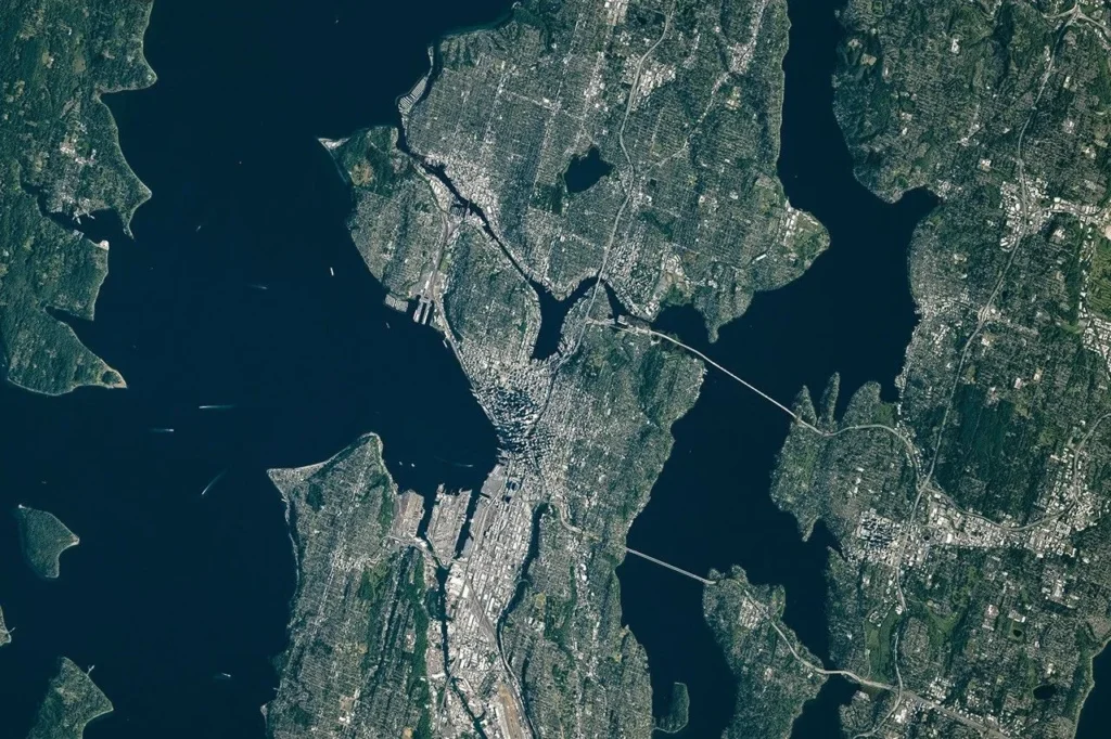
Seattle’s waterfront skyline can make the city look like a simple strip beside the sea. Look inland, however, and another pattern appears: lakes, ridges, narrow waterways and low ground divide the urban landscape. Understanding those connections also explains why a mountain visible beyond the skyline is not one of Seattle’s neighborhood hills.
Seattle lies in western Washington between Puget Sound to the west and Lake Washington to the east. Lake Union and the Lake Washington Ship Canal connect the city’s interior waters to the sound. Glacially shaped hills rise within the city, while the Olympic Mountains and Cascade Range stand farther away.
Read Seattle in three layers: Identify the marine waterfront, follow the canal connection, then locate the distant mountains.
1. Where is Seattle?
Seattle is in the Pacific Northwest of the United States, in western Washington state. Its setting is the Puget Lowland, the broad low-elevation region between the Olympic Mountains on the west and the Cascade Range on the east. The city is not on the exposed Pacific coastline: its marine waterfront faces the sheltered waters of Puget Sound.
Read the city at two scales
At city scale, start with Elliott Bay, Lake Union and Lake Washington. These waters organize the map around downtown and the surrounding neighborhoods. At regional scale, step back to see the Olympic Peninsula, the wider sound and the Cascades. A close-up of central Seattle cannot show those distant ranges at the same useful level of detail.
Seattle is one municipality within a much larger urban region. References to the Seattle–Tacoma metropolitan area, King County or the Puget Sound region describe different areas. This profile focuses on the city’s physical setting.
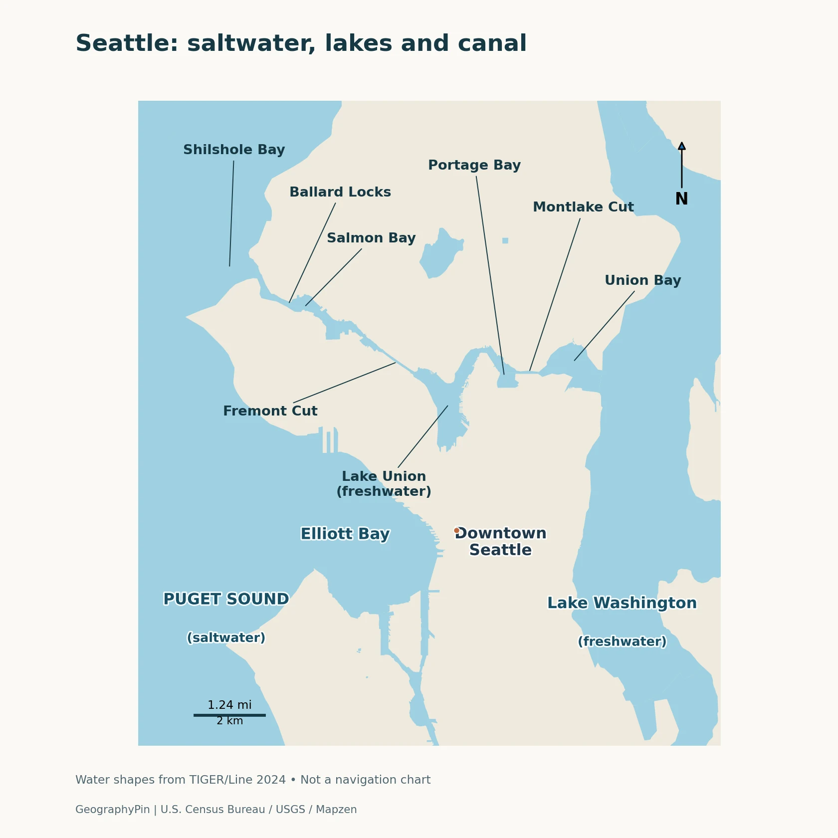
The close-up identifies nearby water bodies and selected reference points. Follow the shores to distinguish the sound, the two lakes and the connecting waterway. Use the separate regional map for the mountain ranges; the maps have different scales.
2. Puget Sound, Elliott Bay and the lakes are different waters
The marine side of Seattle
Puget Sound is a saltwater estuary within the larger Salish Sea. Its deep basins and branching shorelines reflect the region’s glacial history. Fresh water enters from rivers and streams, while marine water connects it to the Pacific system. The word “sound” here does not mean a lake enclosed on all sides by land.
Elliott Bay is part of Puget Sound, immediately beside downtown Seattle. Farther south, the Duwamish Waterway enters the bay. The river mouth is an estuary where river water and seawater meet, and water levels respond to both tides and river flow. It is a different outlet from the ship canal north of downtown.
The freshwater side
Lake Washington lies east of the city, with Seattle along its western shore and other municipalities across the water. Lake Union is a smaller lake within Seattle. Portage Bay forms its eastern arm, while Union Bay belongs to the Lake Washington side of the connection. Similar names do not make these bays interchangeable.
The sound and lakes are connected, but they are not one level, uniformly salty water body. The locks regulate the connection between the freshwater system and tidal marine waters. Saltwater intrusion into the canal can still occur, which is why scientists study salinity as well as temperature there.
3. Glaciers shaped the hills, then people reshaped the ground
Ridges and basins left by ice
Repeated advances of continental ice helped sculpt Seattle’s terrain. Ice and meltwater eroded some areas and deposited sediment in others, leaving a landscape of uplands, elongated hills, valleys and water-filled basins. USGS mapping describes layers of glacial and nonglacial sediment over an irregular bedrock surface, rather than a city built on one uniform slab of rock.
Many uplands are covered by sand and till, the mixture of material deposited directly by glacial ice. Later streams, slope movement and erosion continued to modify the terrain. The result is a patchwork: a ridge, a steep bluff and a low waterfront can lie close together but have different ground conditions.
Seattle’s familiar hill names are useful for orientation, but a fixed count of “seven hills” is not a complete scientific description of its topography.
Regrading and waterfront fill
Large engineering projects altered that inherited landscape. Regrading removed or reduced hills and softened steep routes; Denny Hill is a prominent historical example. Filling low ground and tideflats expanded land available for buildings, transportation and waterfront activity.
The lower Duwamish also changed. Historical surveys show a winding river with marshes and mudflats, while early-twentieth-century channelization straightened and dredged parts of the lower river for industrial navigation. The present waterway combines a natural drainage route with substantial human engineering.
4. How the Lake Washington Ship Canal connects the waters
Follow the connection from east to west
Starting at Lake Washington, the route passes through Union Bay and the Montlake Cut into Portage Bay and Lake Union. It continues through the Fremont Cut and Salmon Bay to the Hiram M. Chittenden Locks, commonly called the Ballard Locks. Beyond the locks, the marine connection leads toward Shilshole Bay and Puget Sound.
This is not a direct canal from Lake Washington to Elliott Bay. It crosses the city north of downtown, using existing water bodies as well as excavated cuts. The Montlake and Fremont cuts are distinct links on opposite sides of Lake Union, not two names for the same channel.
An engineered change in drainage
The early-twentieth-century project lowered Lake Washington by about 9 feet (2.7 meters) and changed the lake’s outlet. The locks raise or lower vessels between the lake system and the tidal marine side. Fish also pass through the system, including through a fish ladder at the locks.
For a map reader, the important distinction is upstream versus downstream of the locks. Salmon Bay is sometimes labeled on both sides of the structure, and sometimes used more narrowly for the upstream water. The position of the locks is a clearer guide to the managed freshwater–marine transition than the bay name alone.
5. Mountain views and rain shadows belong to the regional picture
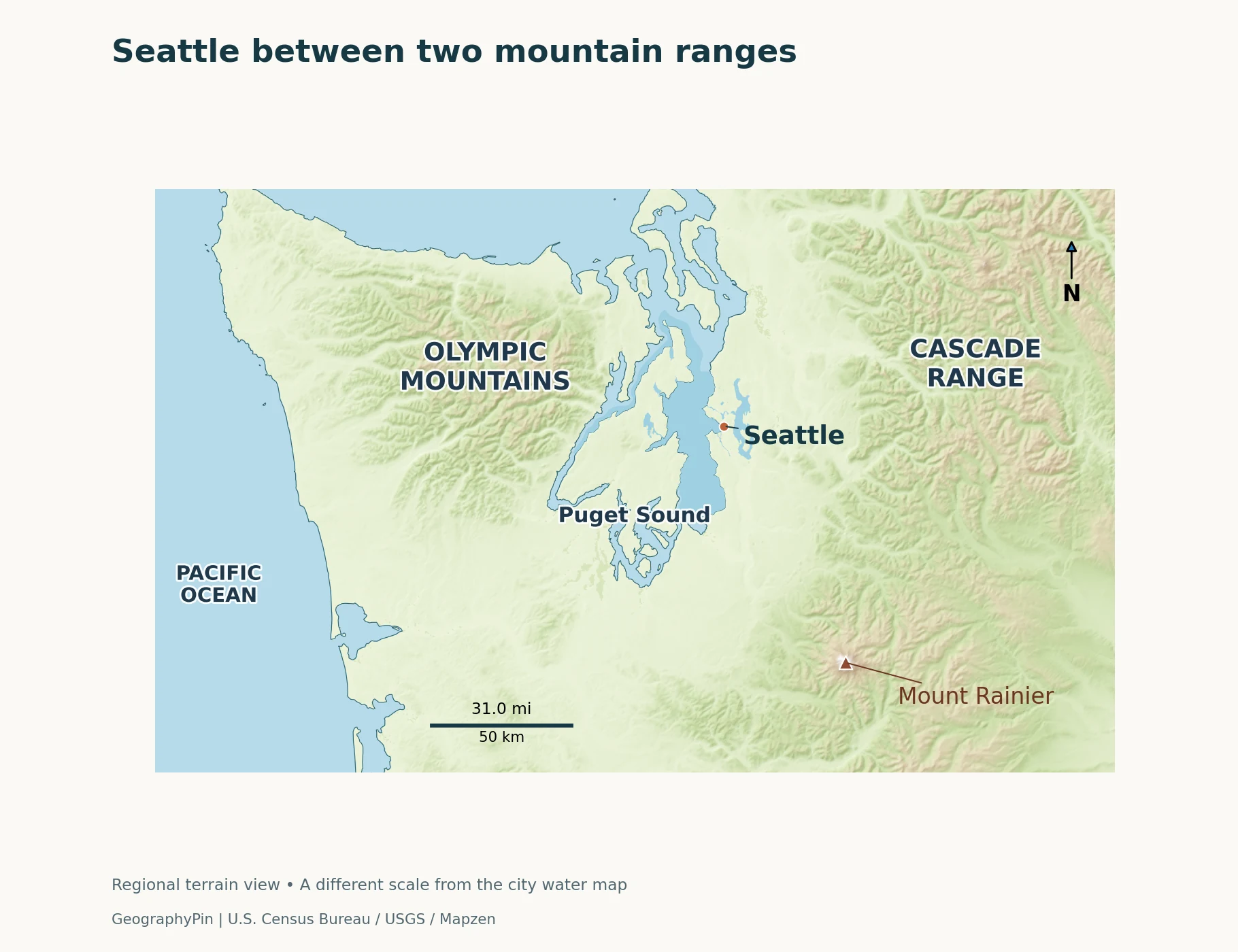
The regional view places Seattle between two mountain systems. It is an orientation map, not a visibility forecast: clouds, haze, terrain and the observer’s position determine which peaks can actually be seen.
Olympics to the west, Cascades to the east
The Olympic Mountains rise on the Olympic Peninsula across Puget Sound from Seattle. The Cascades lie east of the lowland. Mount Rainier, a volcano within the Cascade Range, stands southeast of the Seattle area.
A photograph can compress this separation, especially with a long lens. A prominent mountain behind buildings may appear close even though it lies well beyond the urban area. Reading the regional map alongside the city map prevents that visual impression from becoming a mistaken sense of distance.
Why the rain shadow is not a simple dry-city label
Moist air arriving from the Pacific interacts with the surrounding terrain. The Olympics can partly shelter the central Puget Sound lowlands during storms with suitable wind directions. This is a rain-shadow effect: some moisture is lost as air rises over mountains before reaching locations downwind.
The shelter is not constant. The Washington State Climate Office notes that the central lowlands can be rainshadowed when incoming storm flow is westerly, while local winds often arrive from other directions. Seattle still has a pronounced cool-season wet period and comparatively drier summers. Being partly sheltered does not mean the city is arid or immune to heavy rain.
Regional averages also need their proper scale. The climate office’s Puget Sound Lowlands analysis uses 1991–2020 averages for a broad climate division. Those division-wide values are not measurements for every Seattle neighborhood, and they do not describe the weather on a particular day.
6. A quick guide to reading Seattle’s geography
| Feature | Geographic meaning |
|---|---|
| Puget Sound and Elliott Bay | Marine waters west of the city; Elliott Bay is part of the sound |
| Lake Washington and Lake Union | Freshwater lakes connected through the ship canal system |
| Ballard Locks | Managed transition between the lake system and tidal marine waters |
| Seattle’s hills | Local landforms shaped by glaciation, erosion and human alteration |
| Olympics and Cascades | Distant regional mountain systems, not city hills |
| City versus region | Seattle, King County and the metropolitan area are different geographic units |
The most useful starting point is to identify the water first, then the land between it. Next, separate the local ridges from the distant ranges. Our explanation of physical geography explores the broader links among landforms, water and climate; Seattle illustrates how those natural relationships can also be changed by urban engineering.
Frequently Asked Questions
Is Seattle directly on the Pacific Ocean?
Seattle has a marine waterfront on Puget Sound, part of the Salish Sea, rather than on the exposed Pacific coast. The sound connects to the wider ocean system through inland marine waterways.
Does Lake Washington drain straight into Elliott Bay?
No. Its modern outlet follows the Lake Washington Ship Canal north of downtown, through the lake-and-canal system to the Ballard Locks and Puget Sound. Elliott Bay is a separate part of the sound beside downtown.
What Did We Learn Today?
Seattle’s geography combines marine waters, freshwater lakes and glacially shaped hills within the wider Puget Lowland. The ship canal connects the lakes to the sound, while regrading, fill and river engineering have changed parts of the terrain and drainage. The Olympics and Cascades frame the region and influence its weather, but they must be read at a different scale from the city’s own hills and shorelines.
Sources & Data Notes
The city and regional maps use different scales. Climate discussion concerns geographic patterns, not a forecast; the referenced regional climate baseline is 1991–2020. The historical lake lowering is approximate. The ship canal’s salinity varies with location and operation.
- USGS: Seattle geology and northeastern Seattle geologic mapping.
- Puget Sound Partnership and EPA: Puget Sound and the Salish Sea.
- Seattle biological evaluation, section 6.2: waterway sequence and naming.
- USGS: canal history and 2026 canal model report, covering 2016–20.
- Washington Ecology: Duwamish history; State Archives: historical survey.
- Washington State Climate Office: Puget Sound Lowlands; USGS: Mount Rainier setting.
Maps: GeographyPin cartography using U.S. Census Bureau 2024 water and coastline data. Regional relief uses Mapzen Terrain Tiles via AWS; terrain credits: USGS 3DEP/SRTM/GMTED2010 and NOAA ETOPO1. Each map has its own scale bar.
Featured photograph: NASA / ISS Crew Earth Observations, June 16, 2026; converted to WebP. No NASA endorsement is implied.