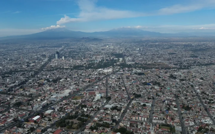
Mexico City’s geography combines three stories that are easy to confuse: a highland basin, a former lake landscape and a metropolis extending beyond the capital’s administrative boundary. Separating them explains why the city is high above sea level, why its population depends on the area being counted, and why groundwater withdrawal can change the ground itself.
Mexico City is Mexico’s capital in the country’s south-central highlands. Its main urban basin lies around 7,350 feet (2,240 m) above sea level, with higher volcanic terrain nearby. Ciudad de México, or CDMX, is a federal entity distinct from the State of México. The wider metropolitan area crosses those administrative boundaries.
Read the city in layers: Start with the map, distinguish the three geographic meanings, explore the surviving lake landscape, and see how subsidence works.
1. Where is Mexico City?
Mexico City is inland in south-central Mexico, on the North American continent. It is not on either the Pacific or Gulf coast. INEGI, Mexico’s national statistics and geography institute, places the capital within the country’s volcanic highland region.
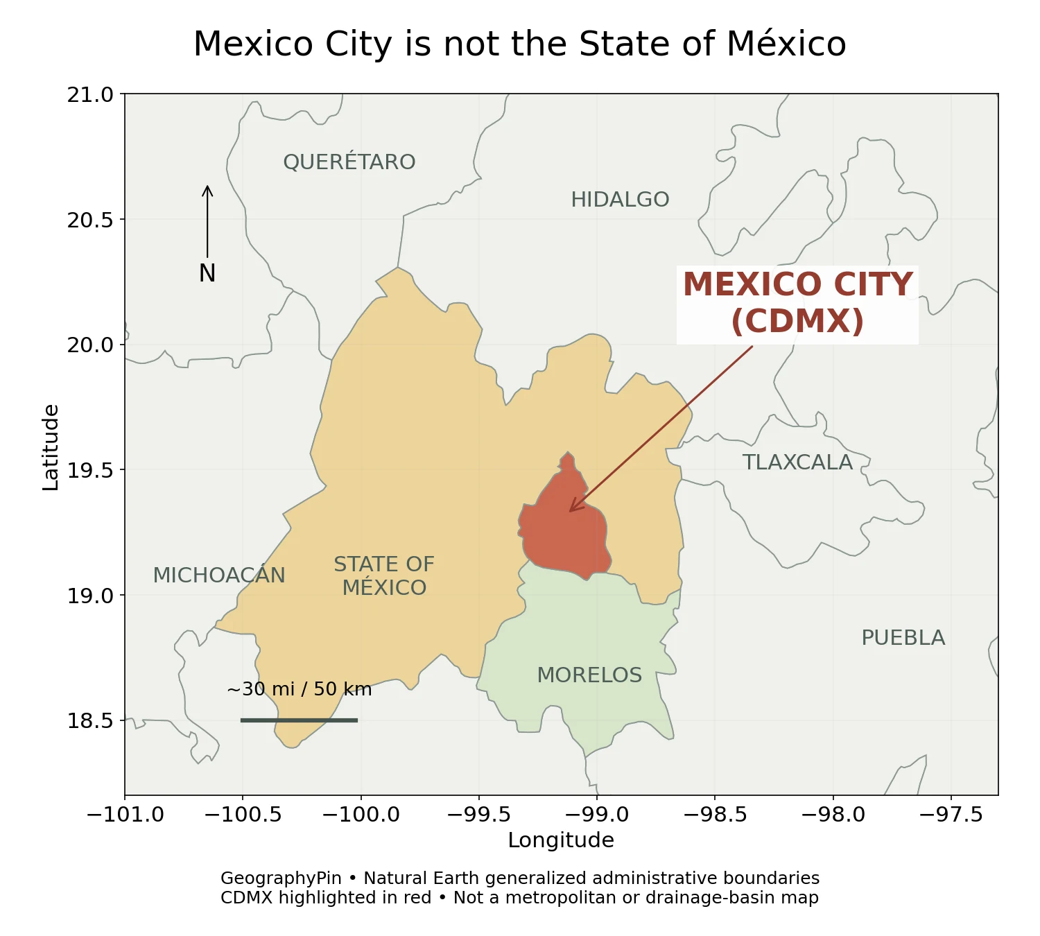
The administrative entity borders the State of México to the north, east and west, and Morelos to the south. On a small national map, CDMX can be hard to distinguish from its larger neighbor. The regional map makes that relationship visible without suggesting that all surrounding territory belongs to the capital.
The urban area and its regional connections extend farther than the red outline. That outline answers an administrative question, while a built-up-area map would answer a different one. For continental context, our guide to North American countries and capitals places Mexico alongside the rest of the continent.
2. Elevation, volcanic highlands and the basin floor
The familiar elevation is not the height of every neighborhood
INEGI’s Aspectos geográficos de Ciudad de México, Compendio 2024 gives the Valley of Mexico an average elevation of about 7,350 feet (2,240 m). That is a useful reference for the main basin setting, not a guarantee that every location inside CDMX has the same altitude.
The southern part of the entity has much more rugged relief. INEGI identifies the Ajusco and Chichinautzin highlands, as well as the Sierra de las Cruces toward the west. The basin floor and surrounding slopes therefore belong to one urban region but differ substantially in terrain.
This highland setting helps explain why Mexico City should not be imagined as a low, tropical coastal city simply because it lies well south in North America. Elevation, relief and seasonal weather all matter. INEGI describes summer rainfall as a major climatic pattern, with cooler conditions in higher southern terrain; there is no single climate value that describes every hillside and basin-floor neighborhood equally well.
For reading a map, separate elevation, height above a reference level, from relief, the variation in height across the landscape. A city can have a high average elevation while parts of its central basin remain comparatively flat.
3. Mexico City, the State of México and the metropolitan area
Three names, three different areas
| Name | Meaning | Common mistake |
|---|---|---|
| Ciudad de México / CDMX | The capital and a federal entity divided into 16 territorial demarcations, commonly called alcaldías. | Treating its boundary as the edge of the whole metropolis. |
| State of México / Estado de México | A separate state adjoining CDMX. | Assuming it is another name for the capital or the entire country. |
| Metropolitan area | A wider urban region whose definition includes places outside CDMX. | Using a metropolitan population as though it counted only CDMX. |
The name Distrito Federal, often shortened to D.F., still appears in older records and map datasets. The city’s official name changed to Ciudad de México in 2016. Historical terminology should not obscure the present distinction between CDMX and the neighboring State of México.
The census figure needs its boundary and date
INEGI counted 9,209,944 residents in Ciudad de México in the 2020 census. This is the population of the federal entity at that census, not a 2026 estimate and not the entire metropolitan population.
Much larger numbers quoted for “Mexico City” often refer to a broader urban or metropolitan definition. They cannot be compared directly with the CDMX census total unless the same geography and reference date are used. Metropolitan delimitations can also change between official statistical exercises.
Even within CDMX, dense urban districts do not represent every landscape. INEGI’s geographic compendium describes both urban and rural localities and substantial southern relief. The administrative capital is not one uninterrupted block of identical buildings. Our explanation of a geographical area shows why boundaries matter whenever a population or land-area figure is quoted.
4. The lake landscape beneath the modern city
From a connected lake system to a transformed urban basin
The Valley of Mexico once contained a connected group of lakes surrounded by mountains and volcanic terrain. Tenochtitlan developed on an island in Lake Texcoco; the Spanish colonial city was subsequently built over the earlier capital. The modern metropolis expanded across much of that former lake landscape and onto adjoining ground.
It is more accurate to say that parts of the city occupy former lake beds than that every part of modern CDMX stands on one drained lake. Hills, volcanic landforms, older shoreline environments and lake sediments are different components of the region.
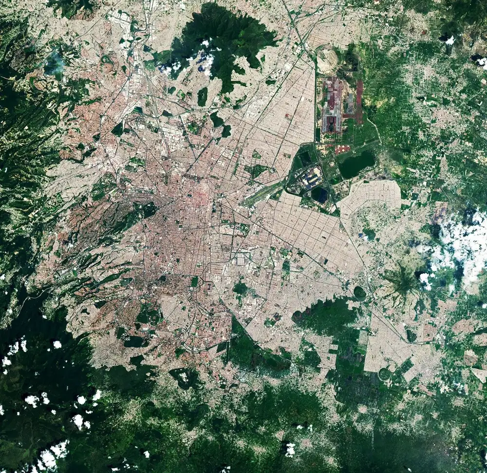
Xochimilco preserves a distinctive connection to that watery past. Its canals and chinampas form a landscape of raised cultivated plots separated by water. Although often called “floating gardens,” the plots are stationary constructed beds, not rafts drifting around a lake.
UNESCO’s Historic Centre of Mexico City and Xochimilco designation recognizes specific heritage areas. It does not mean the entire modern metropolis is one World Heritage property. The satellite image provides landscape context; it does not draw the heritage boundary or identify the condition of every individual plot.
The basin’s drainage has also been altered by engineering. INEGI describes the Valley of Mexico as naturally internally draining, while works such as the Nochistongo cut and deep drainage system created artificial routes outward. “Originally closed basin” is therefore a description of natural geography, not a claim that modern drainage infrastructure has no outlet.
5. Why parts of Mexico City are sinking
Groundwater withdrawal and compressible sediments
Subsidence means lowering of the land surface. In Mexico City, groundwater extraction is a major contributor where susceptible sediments compact. NASA’s 2026 NISAR account links observed sinking in parts of the region to groundwater pumping and compaction of ancient lake-bed material.
The mechanism is not simply an underground cavern being emptied. Water occupies pores between sediment grains. As groundwater pressure declines, more of the load can be carried by the sediment framework, allowing compressible layers to compact. USGS explains this general process particularly for fine-grained silts and clays.
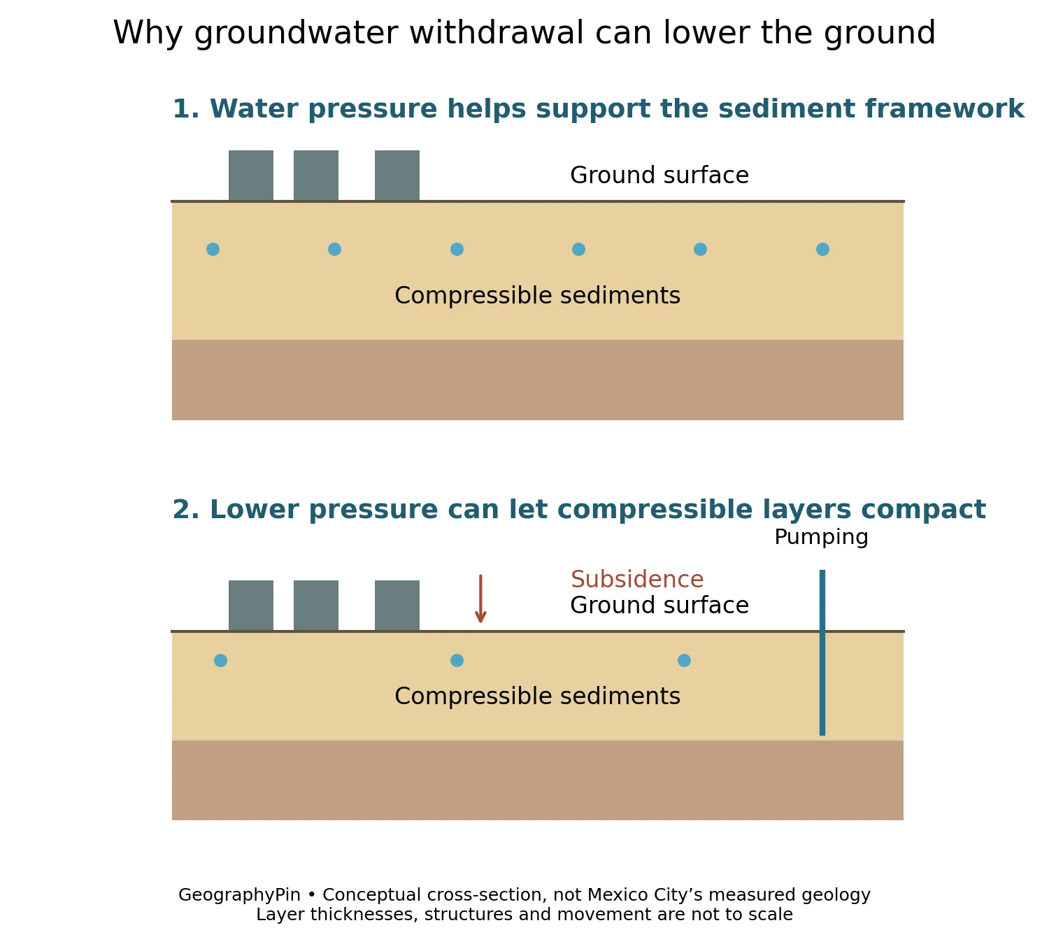
The effect is spatially uneven. A rate measured in one neighborhood or over one satellite-observation interval is not the rate for every street. Changes in geology, pumping and measurement conditions matter, which is why a single dramatic city-wide “sinking per year” number can mislead.
NASA’s example used observations from October 25, 2025, to January 17, 2026. Those dates define the evidence shown in that particular study image; they are not a forecast or an assessment of the safety of an individual building.
Uneven ground movement can complicate structures and water infrastructure. But this regional explanation cannot identify the condition of a specific property. A satellite illustration, a basin map and a site-specific engineering assessment serve different purposes.
6. Water supply and drainage cross different boundaries
A lake history does not mean an unlimited water supply
The city’s water geography includes groundwater wells, imported surface water and engineered drainage. These networks should not be confused with the shape of the original lake basin.
NASA’s account of the 2024 drought describes the Cutzamala system as an inter-basin network of reservoirs and canals conveying surface water toward Mexico City. That helps explain the regional scale of supply: water serving the metropolis can originate beyond the administrative capital and outside its natural basin.
At the same time, removing stormwater and wastewater from low urban ground is a different task from delivering treated water to residents. A city can face pressure on water supply while also needing effective flood drainage. The existence of one problem does not disprove the other.
To read Mexico City accurately, use an administrative map for jurisdiction, a terrain map for elevation, a geological or subsidence study for ground behavior, and a supply-system map for water infrastructure. No single outline or statistic can stand in for all four.
Frequently Asked Questions
Is Mexico City the same as the State of México?
No. Ciudad de México (CDMX) is the capital and a separate federal entity. The State of México is its larger neighbor to the north, east and west.
How high is Mexico City?
The main Valley of Mexico setting is around 7,350 feet (2,240 m) above sea level. Higher slopes and volcanic terrain mean that elevation is not uniform throughout CDMX.
Was all of Mexico City built on a lake?
No. Much of the urban basin occupies former lake environments, but modern CDMX also contains hills and volcanic highlands. The entire administrative entity is not one old lake bed.
Why do Mexico City population figures vary so much?
Some count CDMX itself; others count a wider metropolitan or urban area. INEGI’s 2020 census total of 9,209,944 is for CDMX, not the whole metropolis.
Is the whole city sinking at the same rate?
No. Subsidence varies by location and observation period. Groundwater withdrawal and local sediment conditions help explain the differences; one measured rate should not be applied city-wide.
What Did We Learn Today?
Mexico City is a highland capital whose basin, former lakes and surrounding volcanic terrain still shape urban life. CDMX is distinct from both the State of México and the wider metropolis. Its lake-bed sediments help explain uneven subsidence, while imported water and engineered drainage show why modern infrastructure extends beyond the natural basin and administrative borders.
Sources & Data Notes
Population refers to the 2020 census of CDMX, not a current estimate or metropolitan total. The elevation is a rounded basin reference; neighborhood elevations differ. Historical hydrology is used to explain natural versus engineered drainage, not current flow volumes. The 2024 drought source supports the Cutzamala connection, not a claim about today’s reservoir levels.
The administrative map uses Natural Earth’s generalized first-level polygons, with the source’s historical Distrito Federal label displayed as CDMX. It does not show the urban footprint, a legal survey, the original lakes or the drainage basin. The subsidence figure is an original conceptual diagram. The featured satellite image is credited to NASA Earth Observatory/Lauren Dauphin using USGS Landsat data, dated September 10, 2022, and converted to WebP without changing its geographic content.
- INEGI: Aspectos geográficos de Ciudad de México, Compendio 2024
- INEGI: 2020 census results for Ciudad de México
- Government of Mexico City: city background
- UNESCO: Historic Centre of Mexico City and Xochimilco
- NASA Earth Observatory: Relic Chinampas in Mexico City, 2022
- NASA: NISAR Mexico City subsidence observations, 2026
- USGS: aquifer compaction due to groundwater pumping
- NASA Earth Observatory: Drought Parches Mexico, 2024
- INEGI: historical hydrology synthesis for the State of México, 2001
- Natural Earth public-domain terms
- NASA image and media use guidelines