Savannah is recognizable for its squares and older buildings, but those streets are only one part of the city. Its river setting connects a planned colonial center, a history of slavery and civil rights, and a modern economy of shipping, aircraft manufacturing and art education.
A working port around a historic grid
Savannah is a city in coastal Georgia, in the southeastern United States, on the Savannah River upstream from the Atlantic Ocean. It is known for a historic street plan organized around public squares, but its identity also includes a working port, aircraft manufacturing, art education and a substantial civil rights history.
Find your starting point: Distinguish the city and its neighbors, understand the repeating squares, or read about Black civic life.
1. Where is Savannah?
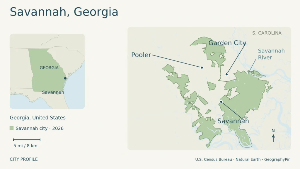
Savannah lies in southeastern Georgia, beside the lower Savannah River near the Atlantic coast. The river connects the city with the ocean and separates Georgia from South Carolina. Downtown is a riverfront settlement, not an oceanfront beach town: the U.S. Fish & Wildlife Service describes the original settlement site as about 18 miles (29 kilometers) upstream from the ocean.
The map above shades Savannah’s municipal territory, not its historic district or metro area. Dots are representative place points, not downtown locations. Enlarge map.
The Georgia (U.S. State) profile places Savannah within the state’s wider geography.
The city and its neighbors
Savannah is a municipality within Chatham County, not another name for the entire county. Chatham County also lists Garden City, Pooler, Port Wentworth, Thunderbolt and Tybee Island as separate incorporated communities. That distinction matters when reading about the port, the coast or the wider Savannah economy: nearby places can share regional connections without belonging to the same city government.
The historic center occupies only part of modern Savannah. Its familiar squares should not be mistaken for the municipal boundary, nor should the city population be used as the population of the whole metropolitan area.
2. A river bluff, wetlands and a planned center
Yamacraw Bluff provided the setting for the colonial town. Along the river, the contrast is between the raised settlement site and the surrounding low coastal landscape. Nearby Savannah National Wildlife Refuge protects tidal freshwater marsh and bottomland hardwood forest on both sides of the state line. The region is therefore more varied than a simple picture of beaches and salt marsh.
Parts of that wetland landscape also carry a human history. The Fish & Wildlife Service describes former rice plantations where enslaved African and African American workers, alongside immigrant Irish laborers, cleared land and constructed canals and levees. Later refuge management reused water-control infrastructure for wildlife habitat. The river’s surroundings are both an ecosystem and a worked historical landscape.
Why the squares repeat
The historic center grew through a repeated unit called a ward. A public square formed its center, with sites for public buildings to the east and west and residential lots to the north and south. Repeating that arrangement allowed the town to extend southward while retaining a recognizable pattern of streets and open spaces.
The Historic Savannah Foundation describes the National Historic Landmark District as extending from the Savannah River to Gwinnett Street, between East Broad Street and Martin Luther King Jr. Boulevard. Within it, houses, churches and commercial buildings come from different periods. The colonial plan is older than much of the architecture standing on it: Regency houses, Greek Revival buildings and later Victorian styles belong to successive stages of urban growth.
3. A history beyond the picturesque streets
James Oglethorpe and British colonists established Savannah in 1733, but the site was not an empty landscape. The Georgia Historical Society documents the Yamacraw community led by Tomochichi and the role of interpreter Mary Musgrove in negotiations with Oglethorpe. Their diplomacy was central to the settlement’s establishment. Telling the city’s founding solely as an English planning achievement leaves out the people who made that agreement possible.
The later city depended on slavery in ways that extended beyond plantations. Savannah’s Municipal Archives documents enslaved people used by city departments and hired out for infrastructure projects. This history belongs to the streets and public works as well as to private households.
Telfair Museums’ Owens-Thomas House & Slave Quarters gives a specific domestic example. Completed in 1819, the house displayed a wealthy family’s status, while enslaved people cooked, cleaned, did laundry and cared for children. Its surviving working spaces and quarters explain how that household functioned. Architecture alone cannot tell the whole story of the wealth visible in Savannah’s older buildings.
The colonial founding and the creation of municipal government are different dates. The city archives record incorporation on December 23, 1789, followed by the first aldermanic election in March 1790. The present City Hall opened in 1906. Savannah later adopted a council-manager system under a 1953 charter, with its first city manager hired in 1954.
Black civic life and the civil rights movement
Savannah’s Black history did not end with emancipation. The Ralph Mark Gilbert Civil Rights Museum preserves the local struggle against Jim Crow segregation, including the work of Gilbert, Westley Wallace Law and the NAACP. Law led the local chapter from 1950, and the museum connects lunch-counter sit-ins and the boycott of Broughton Street businesses with the desegregation campaign.
The museum’s archives also preserve sermons, plays and organizing records, showing how churches, cultural work and political action overlapped. These histories make the city’s center more than a collection of old facades: it was also a place where residents challenged exclusion and changed public life.
4. The working city: port, aircraft and art
Savannah remains a working port rather than simply a preserved historic town. Georgia Ports Authority operates major container facilities at Garden City Terminal and Ocean Terminal. Its June 2026 account of Ocean Terminal’s renovation describes ship berths, truck gates and a connection carrying departing trucks toward U.S. 17 and Interstate 16. Freight activity links the river to inland markets and helps explain the importance of warehouses and transport infrastructure around the city.
The June 2026 announcement described yard construction continuing into later years. Its proposed capacity increases are plans, not completed facilities.
Aviation manufacturing is another part of Savannah’s economy. Gulfstream identifies the city as its home since 1967 and locates its worldwide headquarters, research and development, aircraft manufacturing and completion facilities, and customer support on its Savannah campus. Those activities add an industrial and engineering role that a downtown-only portrait would miss.
Art education has also reshaped the use of older buildings. The Savannah College of Art and Design was founded in 1978 and began teaching in the former Savannah Volunteer Guards Armory in 1979. Its facilities are spread through the city rather than confined to a single isolated campus. This is one reason historic buildings can be part of everyday educational life, not only museum collections.
5. Savannah in dated city facts
The Census Bureau’s figures below describe Savannah city. The population estimate and land-area figure refer to different dates; the land figure is not a newly measured 2025 boundary.
| Measure | Figure and date |
|---|---|
| Population estimate | 149,440, July 1, 2025 (Vintage 2025) |
| Census population | 147,780, April 1, 2020 |
| Land area | 106.85 square miles (276.74 square kilometers), 2020 |
| Municipal incorporation | December 23, 1789 |
| Government form | Council-manager |
For understanding the place, the river setting, repeated squares and working industries are more revealing than a population ranking. For where to stay, a squares walk and a separate coastal excursion, use the Savannah travel guide and itinerary.
What Did We Learn Today?
Savannah makes most sense as a river city with several overlapping histories. Its repeated squares explain the older urban plan; Indigenous diplomacy, enslaved labor and the civil rights movement explain people and power within it. The port, Gulfstream and SCAD show why the city is not frozen in that past, while municipal facts keep Savannah distinct from its surrounding communities.
Sources & Data Notes
Open sources and data notes
Population uses Census Vintage 2025 estimates and the separate 2020 census count; land area is the 2020 Census figure, converted to square kilometers and rounded. Port construction is described from a dated June 2026 announcement, not represented as complete. Historical accounts draw on city archives, museums and the Georgia Historical Society.
- U.S. Census Bureau: Savannah city QuickFacts
- Chatham County: Incorporated Cities & Towns
- U.S. Fish & Wildlife Service: Savannah refuge setting and history
- Historic Savannah Foundation: National Historic Landmark District
- Georgia Historical Society: Tomochichi biography
- City of Savannah: Municipal Slavery research
- Telfair Museums: Owens-Thomas House & Slave Quarters
- City of Savannah: City History
- Ralph Mark Gilbert Civil Rights Museum: local movement and archives
- Georgia Ports Authority: Ocean Terminal renovation, June 11, 2026
- Gulfstream Aerospace: Savannah headquarters and facilities
- SCAD: Savannah buildings and institutional history
- Original GeographyPin map: U.S. Census TIGER/Line 2026 place boundaries, effective January 1, 2026, and 2025 area-water layers; Natural Earth v5.1.1 inset. Public-domain data. The scale applies to the local map.