Columbus, Georgia, grew where the Chattahoochee River could carry goods downstream and power mills beside its falls. Its modern identity joins that industrial inheritance with Black cultural history, a major military neighbor, corporate offices and a university woven into the old commercial center.
Georgia’s city on the Chattahoochee
Columbus is a consolidated city-county in west-central Georgia, United States, on the Chattahoochee River opposite Alabama. It shares its geographic area with Muscogee County and is distinct from Columbus, Ohio. River-powered industry shaped its growth; insurance, military connections and university life help explain its modern role.
Find your starting point: Explore the river and falls, understand the city-county extent, or trace the university’s Uptown role.
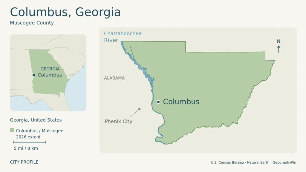
The map above shows Columbus’s citywide extent, matching Muscogee County in the 2026 Census geography. It is larger than the built-up riverfront; dots locate places generally, not visitor entrances. Enlarge map.
1. A Chattahoochee River city on Georgia’s western edge
The river explains the location
Columbus lies on the east bank of the Chattahoochee River in west-central Georgia. Alabama is across the river. This is Columbus in the U.S. state of Georgia, not Columbus, Ohio. The river gave the Georgia city both a boundary and a reason to develop here. For the wider setting, see the Georgia state profile.
At Columbus, the Chattahoochee crosses the Fall Line through a reach of falls and rapids. The location once marked the upstream limit of river navigation, allowing a trading town to connect inland producers with downstream markets. Falling water also supplied power for mills, so transport and manufacturing grew from the same physical setting.
The Historic American Engineering Record documents a gristmill operating in 1828 and several textile mills by the 1840s. Water wheels and turbines drove machinery before hydroelectric generation developed in the late nineteenth century. The riverfront’s industrial buildings reflect that long progression from moving goods to powering production.
2. Columbus and Muscogee County share a government
One city-county area, not a separate balance
Columbus and Muscogee County consolidated their governments on January 1, 1971. Bibb City, a textile community within the county, initially retained its own municipal government. Its charter was repealed in 2001, bringing that community into the consolidated government.
Today, Columbus city and Muscogee County cover the same geographic area. The Census Bureau lists the place as Columbus city, Georgia, not a consolidated-government “balance.” There is no separate Bibb City population to subtract from the modern city figure.
The Census Bureau estimated 202,171 residents on July 1, 2025, in its Vintage 2025 release. The April 1, 2020 census counted 206,922. Muscogee County’s corresponding population figures match those city totals, although the Census maintains separate city and county records.
This city-county extent is larger than the historic riverfront settlement. It is also different from the wider metropolitan region, which reaches beyond Muscogee County. A municipal outline locates the modern jurisdiction; it does not mean every part inside the boundary is densely built or that neighboring Alabama communities are part of Columbus.
3. A planned trading town on Muscogee land
The history of this place did not begin with its town plan. Muscogee, also known as Creek, communities lived and traded in the Chattahoochee Valley before the Georgia town was established. Chattahoochee Valley Libraries’ local-history exhibition places Columbus’s development within the dispossession and forced removal of those communities.
Georgia authorized a trading town near the falls in 1827. Commissioners arranged the layout, and lots went on sale in July 1828. Columbus was incorporated later that year. Its planned streets and riverfront position served the state’s aims of expanding settlement and developing trade along its western boundary.
Cotton brought agricultural producers, merchants and transport workers into the town’s economy. Manufacturing subsequently increased the value of the river as a power source. Rail connections in the nineteenth century changed the movement of goods, but the riverside mills remained an important part of Columbus’s industrial geography.
The city’s built environment also depended on enslaved labor. The libraries’ exhibition documents bricks made by enslaved people for St. Elmo, an 1833 house, and the broader practice of hiring enslaved workers out for urban construction. Surviving architecture records the wealth of owners, but its history also belongs to the people whose forced labor helped create it.
4. Ma Rainey and the city’s Black cultural history
Gertrude “Ma” Rainey connects Columbus with the national history of the blues. Her career took her far beyond Georgia, through touring performances and the recording world of the 1920s. The National Register documentation for her Columbus home recognizes the importance of her work to American music, Black history and women’s history.
After her mother’s death in 1935, Rainey returned to the house on Fifth Avenue and lived there until her own death in 1939. The home gives a local setting to a career often remembered through records and distant stages. It also connects that career with family and neighborhood life.
That distinction matters in understanding a city’s cultural identity. Columbus was not the setting for every part of Rainey’s professional success, but it remained an important personal place. Her story adds a different perspective to the riverfront mills and military institutions that often dominate accounts of the city.
5. Insurance, the military and university life
Columbus’s business connections extend beyond its former mill economy. Aflac traces its beginnings to the American Family Life company founded in Columbus in 1955 by John, Paul and Bill Amos. The insurer remains headquartered in the city and operates in both the United States and Japan, linking a local corporate base to international markets.
Fort Benning provides another major regional connection. The Army installation lies across the Georgia–Alabama border next to Columbus and houses the Maneuver Center of Excellence, Infantry and Armor schools, and other military organizations. Its role brings soldiers, civilian employees and families into the surrounding community. The post is not simply another name for the city, and its population or workforce should not be added to a city total without checking geographic scope.
The current name is Fort Benning. The Army changed it from Fort Moore in 2025, honoring World War I soldier Fred G. Benning. Older sources using Fort Moore reflect the installation’s previous name, not a different nearby base.
Education has changed the urban landscape
Columbus State University began as Columbus College in 1958, initially using a renovated hosiery mill. It moved to its main campus in 1963 and became Columbus State University in 1996. Its own development shows how buildings and land associated with older industries could acquire new uses.
The university later expanded into the historic center, commonly called Uptown. The RiverCenter for the Performing Arts opened a new phase in 2001, and the art and theater departments moved to RiverPark in 2007. Teaching spaces, performance facilities and student housing brought everyday university activity into the older commercial district.
6. A changing riverfront and dated city facts
The Chattahoochee’s role has continued to change. Columbus’s fiscal 2013 financial report describes a whitewater project that breached two dams and reshaped parts of the riverbed. It converted a former industrial reach into a recreational setting through deliberate engineering, rather than simply leaving an untouched river in place.
Alongside the university’s Uptown expansion, that project illustrates a broader change in how the city uses its historic center. Water and old buildings remain central, but education, public space and recreation now stand alongside the earlier stories of transport and manufacturing.
| Fact | Value |
|---|---|
| River and neighboring state | Chattahoochee River; Alabama |
| Town incorporation | 1828 |
| City-county consolidation | January 1, 1971 |
| 2020 census population | 206,922 on April 1, 2020 |
| Population estimate | 202,171 on July 1, 2025; Vintage 2025 |
| Land area | 216.50 square miles (560.73 square kilometers), 2020 Census geography |
To turn that background into a visit, the Columbus travel guide separates Uptown walking, museum trips and guided river activities, with practical base and transport choices.
What Did We Learn Today?
The Chattahoochee made Columbus a trading and manufacturing center, but its history also includes Muscogee displacement, enslaved labor and Ma Rainey’s cultural legacy. Consolidation created today’s city-county geography. Corporate and military connections broaden its reach, while the university and a redesigned riverfront show how older urban spaces can take on new roles.
Sources & Data Notes
Open sources and data notes
Population and land area use Columbus city, Census FIPS 1319000. Muscogee County’s corresponding population and land-area values were cross-checked; this is not a balance excluding a separate Bibb City. Census counts, annual estimates and boundary years are distinct. The metric land-area conversion is rounded. Historic reports support past events, not present business counts or visitor access. Army sources confirm the current Fort Benning name. HAER historical research is credited to John S. Lupold, J. B. Karfunkle and Barbara Kimmelman.
Original GeographyPin map: U.S. Census Bureau 2026 city, county and water geography, with Natural Earth city and state context. Map boundaries and the table’s 2020 land-area figure have different vintages.
- U.S. Census Bureau: TIGER/Line geographic data
- Natural Earth: public-domain map data
- U.S. Census Bureau: Columbus city QuickFacts
- U.S. Census Bureau: Muscogee County QuickFacts
- Columbus Consolidated Government: FY2006 financial report, reporting entity, p. ii
- Chattahoochee Valley Libraries: Colonization, Hear Us Talking exhibition
- John S. Lupold, J. B. Karfunkle and Barbara Kimmelman: HAER GA-22, Water Power Development at the Falls of the Chattahoochee, 1977, pp. 1–3
- Chattahoochee Valley Libraries: Built by Enslaved Peoples
- National Register nomination: Gertrude “Ma” Pridgett Rainey House, significance statement
- Aflac: company history and Columbus headquarters
- U.S. Army: About Fort Benning
- U.S. Army: Fort Benning redesignation ceremony, April 2025
- Columbus State University: institutional and RiverPark history
- Columbus Consolidated Government: FY2013 financial report, whitewater project, p. vi