Oman’s geography changes sharply from the Hajar Mountains and northern coast to the desert interior and southern Dhofar. In summer, Salalah’s surroundings can become misty and green while much of the country remains hot and dry. A separate northern territory, Musandam, adds another important feature to the national map.
Oman lies on the southeastern Arabian Peninsula, with Muscat as its capital. Its land neighbors are the United Arab Emirates, Saudi Arabia and Yemen. The main landscapes include the Hajar Mountains, coastal plains, interior deserts and Dhofar’s southern mountains and coast. Musandam is separated from the main Omani landmass by UAE territory.
How to use this article: Locate Oman in the region, compare its main landscapes, understand the southern khareef, or check dated country facts.
1. Where Oman Is: Mainland, Musandam and Connected Seas
The capital and northern exclave are different places
Oman occupies the southeastern corner of Arabia in Western Asia. The main landmass faces the Gulf of Oman to the northeast and the Arabian Sea farther south and east. Musandam projects toward the Strait of Hormuz, north of the main national territory.
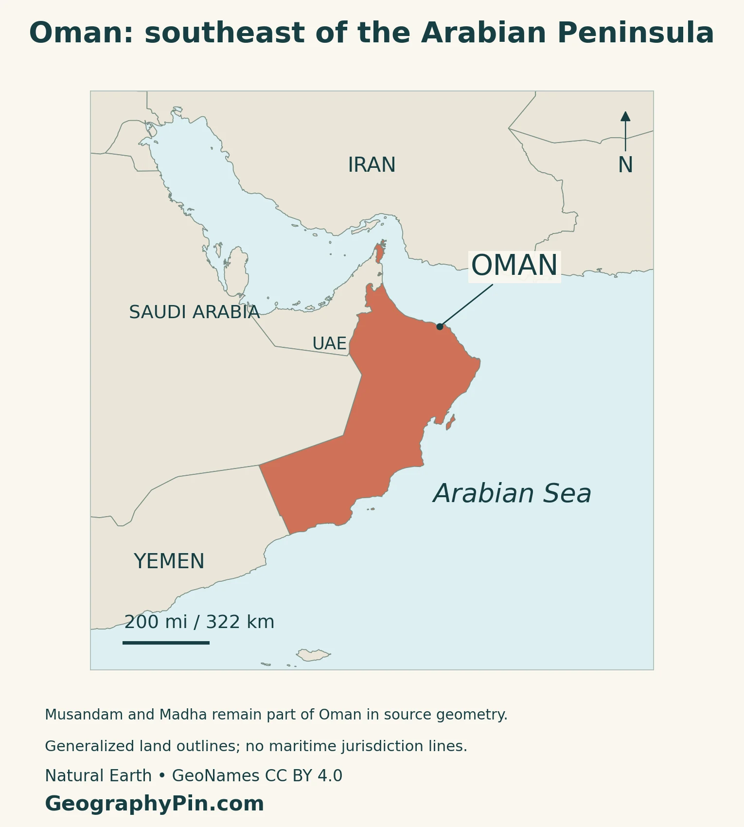
The Gulf of Oman, also called the Sea of Oman in Omani sources, connects the Arabian Sea with the Strait of Hormuz. The strait leads into the Persian Gulf, commonly called the Arabian Gulf in regional sources. These names identify connected but distinct waters.
Musandam is an exclave: part of Oman separated by land belonging to another country. It is not Muscat, and its position near the strait should not be transferred to the capital. Our Muscat geography guide explains the capital’s more specific coastal setting.
For a wider map, use the Arabian Sea guide. Oman also appears in our Middle East country reference and Asia countries and capitals list, which explain their regional counting conventions.
2. Hajar Mountains, Coastal Plains and Interior Deserts
Compare the northern uplands with the interior
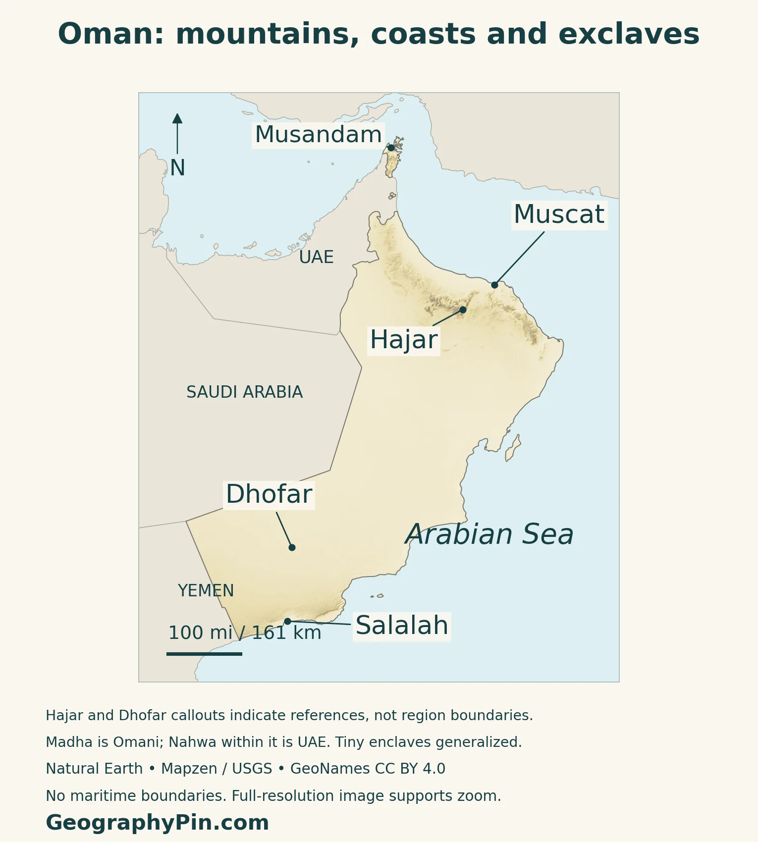
The Hajar Mountains form a broad arc through northern Oman, close to the Gulf of Oman coast. The Al Batinah plain occupies lower terrain between the mountains and the sea. Valleys cut through the uplands and connect coastal and inland places.
| Setting | What distinguishes it |
|---|---|
| Hajar and northern coastal plain | Mountain relief close to a lower sea-facing strip |
| Interior deserts | Sand seas, stony ground and broad dry plains |
| Dhofar | Southern mountains and coast, with a localized summer monsoon influence |
| Musandam | Northern mountain peninsula separated from the main national landmass |
The relief colors show elevation, not vegetation, rainfall or administrative boundaries. In particular, green seasonal vegetation in Dhofar is a climate response, whereas green on an elevation map may simply mean lower ground.
Not all Omani desert is a dune field
The interior contains both sandy and rocky landscapes. Sharqiya Sands, also known as Wahiba Sands, is a distinct sand-sea region in eastern Oman. Farther west, Oman reaches the Rub al Khali, or Empty Quarter, which extends across national borders.
Jiddat Al Harasis is a contrasting stony desert landscape in central Oman. Naming these settings separately is more useful than treating every pale area on a country map as the same kind of sand.
NASA’s northern Oman imagery highlights the difference between western sand and the rugged uplands. Limestone, igneous rocks and metamorphic rocks occur in the northern mountains. Their relief reflects a geological history different from the wind-shaped surfaces of a sand sea.
3. Why Salalah’s Khareef Differs from Much of Oman
The southern monsoon is a regional pattern
Khareef is the summer monsoon season associated with Dhofar’s coastal mountains and the Salalah area. Oman’s meteorological authority describes persistent drizzle, low cloud and humid air, generally from late June into September. The seasonal change can stimulate vegetation growth on slopes that are much drier at other times.
Moist maritime winds and mountain relief shape this regional pattern, which does not extend across all Oman.
The sea can help cool the coast in summer
The meteorological authority also links the southeastern coastal climate to upwelling. During the monsoon, cooler subsurface water rises toward the sea surface. Air moving over that cooler water helps moderate conditions along parts of the coast.
Northern Oman has its own rainfall pattern
Northern mountain environments differ from Dhofar. NASA’s landscape account describes winter precipitation in the northeastern uplands, alongside occasional storms at other times. A calendar that is useful for one part of Oman is not automatically a description of the whole country.
These are broad climate patterns rather than a forecast. Seasonal dryness and short periods of intense rain can both occur within the same regional climate.
4. Wadis, Aflaj and the Geography of Water
Valleys connect mountains with lower ground
Wadis are valleys or channels that can carry runoff, often intermittently. Their importance is not limited to the days when water is visible: they organize drainage, provide routes through terrain and help explain where sediment and moisture collect.
Oman’s meteorological service identifies rainfall as a source of groundwater recharge as well as support for vegetation and agriculture. A dry landscape can therefore depend on rain that arrives irregularly and enters the ground rather than forming a continuously flowing river.
A channel and a supply system are not the same thing. Natural drainage follows terrain, while people build and manage structures that capture, distribute or store water. Reading both together helps explain the location of settled and cultivated land.
Irrigation is both infrastructure and shared management
The UNESCO-listed Aflaj Irrigation Systems of Oman comprise five component systems. Aflaj is the plural of falaj. These systems use gravity to carry water from underground sources or springs toward agricultural and domestic users.
Their significance extends beyond the channels themselves. Water sharing, maintenance, agricultural land and neighboring settlements form a connected cultural landscape. UNESCO also records watchtowers associated with protecting the systems.
The five listed examples represent a wider irrigation tradition; they are not a claim that Oman has only five aflaj. Nor does a historic irrigation channel demonstrate that its water supply is unlimited today.
5. Muscat, People and Dated Country Facts
Muscat is the national capital
Oman’s 2021 Basic Law identifies Muscat as the capital and Arabic as the official language. It establishes a hereditary sultanic system of government.
| Item | Reference |
|---|---|
| Capital | Muscat |
| Registered population | 5,359,557 at the end of December 2025, NCSI |
| Total area | About 119,500 square miles (309,500 square kilometers), Foreign Ministry figure |
| Official language | Arabic |
| Currency | Omani rial (OMR), divided into 1,000 baisa |
| Government | Hereditary sultanate |
| Administrative divisions | 11 governorates, subdivided into wilayats |
Use the date attached to the population figure
The 2026 Statistical Year Book reports the population registered at the end of December 2025. Its publication year is therefore not the reference year of the population total. The figure includes both Omani citizens and expatriates, rather than citizens alone.
NCSI’s nationality totals for that reference date are 3,039,349 Omanis and 2,320,208 expatriates.
Governorates do not coincide with physical regions
Oman’s 11 governorates are administrative units, each containing wilayats. A physical label such as the Hajar Mountains describes terrain across a broader landscape rather than one governorate with a matching outline.
Musandam Governorate includes Khasab, Bukha, Dibba and Madha. Madha is an Omani enclave within the UAE; it in turn surrounds Nahwa, which belongs to the UAE emirate of Sharjah. This small nested arrangement is distinct from the larger Musandam peninsula.
The maps retain those source-geography components rather than merging Oman and the UAE into smoother outlines. The small northern territories require enlargement to read properly, while the main national map shows their relationship to the rest of Oman.
6. Frankincense Landscapes and Maritime Connections
Dhofar links inland production with coastal trade
UNESCO’s Land of Frankincense property brings together frankincense trees at Wadi Dawkah, the caravan oasis of Shisr/Wubar, and the ports of Khor Rori and Al-Baleed. Together they show a historical relationship between inland resources, water stops and maritime trade.
The sites are separate components of one heritage property, not a single city or a label for every frankincense-growing area. Their combined geography explains the trade more clearly than looking at the trees or the ports in isolation.
A modern port on the Arabian Sea
Salalah also has a modern maritime role. Its terminal operator describes the port as an Arabian Sea transshipment hub handling containers and other cargo types. Transshipment means transferring cargo between services as part of a wider transport network.
The port’s position connects southern Oman with routes toward East Africa, the Indian subcontinent and other regions. This is different from Musandam’s position at the Strait of Hormuz or Muscat’s location on the Gulf of Oman.
Frequently Asked Questions
Why does Salalah have a different summer climate from Muscat?
Salalah’s surrounding coast and mountains are influenced by Dhofar’s khareef monsoon. Moist marine air, cloud, drizzle and coastal cooling create a regional summer pattern that does not apply to all Oman.
Is Musandam part of Oman or the UAE?
Musandam is part of Oman, separated from the main Omani territory by UAE land. It is distinct from Muscat, which lies on Oman’s main landmass.
What Did We Learn Today?
Oman combines northern mountains and coastal plains with interior deserts, southern Dhofar and the separated Musandam territory. Comparing those settings explains why one national climate label is insufficient. Wadis, irrigation systems, caravan sites and ports also connect the physical landscape with the ways people have settled, cultivated and traded across it.
Sources & Data Notes
Population follows NCSI’s registered population at the end of December 2025, published in the 2026 Statistical Year Book. It includes Omanis and expatriates and is not a 2026 census or live count. Total area follows the Foreign Ministry figure; no density is calculated from differing area series. Legal references use the 2021 Basic Law, not its repealed 1996 predecessor. Older landscape sources support stable geography, not current demographic, port-performance or hazard claims.
- Oman Ministry of Information: broad northern relief, Al Batinah, wadis and Jiddat Al Harasis
- Oman Foreign Ministry: total area and broad physical setting; undated population and peak-ranking claims not used
- Oman Foreign Ministry: 11 governorates and Musandam territorial context
- NASA Earth Observatory (2008): northern mountain imagery, rocks and general seasonal contrasts; old elevations not used
- Royal Geographical Society: Sharqiya/Wahiba Sands terminology; area and directional details not used
- Oman Directorate General of Meteorology (2025): regional khareef timing, drizzle and mountain setting
- Oman Directorate General of Meteorology (updated May 2026): coastal upwelling, cloud and summer moderation
- Oman Directorate General of Meteorology: rainfall, groundwater recharge and runoff
- UNESCO: five listed Aflaj Irrigation Systems, gravity-fed channels and shared management
- NCSI Statistical Year Book 2026: registered population at end-December 2025 and nationality totals
- Royal Decree 6/2021 and Basic Law, Articles 1, 3 and 5; reproduced legal text and translation
- WIPO Lex: record confirming the 2021 Basic Law and repeal of the 1996 predecessor
- Oman Foreign Ministry: rial and 1,000-baisa subdivision; obsolete legal reference not used
- Sharjah Tourism: UAE Nahwa within Omani Madha
- UNESCO: Land of Frankincense, inland production, caravan oasis and historical ports
- APM Terminals: Salalah port location and cargo functions; rankings, capacities and safety promotions not used
Map method: Original GeographyPin maps use public-domain Natural Earth country geometry and GeoNames locations under CC BY 4.0, selected, reprojected and labeled. Relief uses Mapzen Terrain Tiles and USGS elevation data, not a vegetation map. Hajar and Dhofar markers are geographic references, not boundaries. All six source components are retained, including Musandam and Madha; UAE Nahwa remains outside Omani fill. Tiny enclaves are generalized and require enlargement. No maritime jurisdiction lines are drawn. The decorative flag-filled feature follows the flag and emblem annexes of Royal Decree 99/2026, effective November 2, 2026, rather than an older flag specification.