Lake Victoria looks like a single blue shape on a map, but its geography involves three different scales: the lake shared by three countries, the larger catchment reaching five countries, and the Nile system downstream. Keeping those scales separate also helps explain why its impressive surface area does not mean exceptional depth.
Lake Victoria is a large freshwater lake in East Africa, shared by Uganda, Kenya and Tanzania. It crosses the Equator and is Africa’s largest lake by surface area, but is relatively shallow. Its wider catchment also reaches Rwanda and Burundi, while its northern outlet connects to the Nile system.
How to use this article: Start with the three lakeshore countries, compare the measurement sources, then follow the Nile connection or explore the lake-breeze explanation.
1. Where is Lake Victoria?
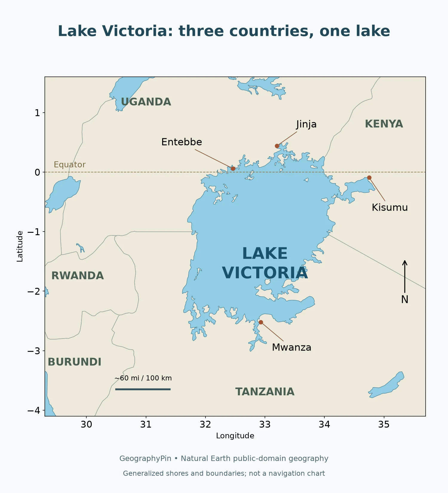
Three countries share the lake
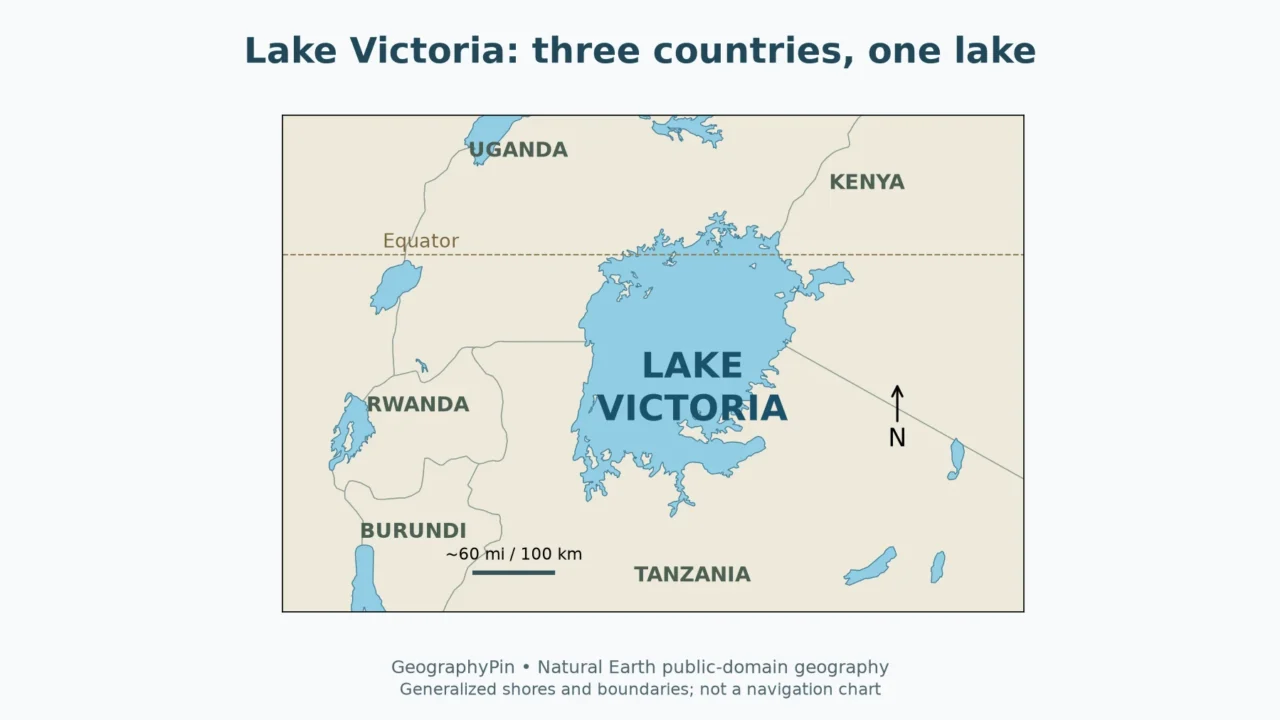
Lake Victoria lies in East Africa and crosses the Equator. Uganda borders its northern side, Kenya reaches the northeastern shore around the Winam Gulf, and Tanzania borders the southern part. Much of the lake lies south of the Equator, but its northern waters extend into the Northern Hemisphere.
The lake is not contained within a single country. Nor should a map of its surroundings be read as a map of five lakeshore states: Rwanda and Burundi are relevant to the wider catchment, not to the shoreline itself. The distinction between a lake and its drainage basin is the most useful starting point for understanding this part of Africa.
Several cities help orient the map. Entebbe and Jinja are on the Ugandan side, Kisumu is by the Winam Gulf in Kenya, and Mwanza is on the Tanzanian side. These labels locate different parts of the shore; they do not imply that a city controls the lake or that its urban boundary follows the water.
The catchment extends beyond the shore
A catchment or drainage basin is the area from which water drains toward a water body. Lake Victoria’s catchment reaches into Kenya, Tanzania, Uganda, Rwanda and Burundi. Rain falling well away from the lake can therefore become part of its water supply after passing through tributaries, wetlands and smaller channels.
The Kagera system is an important example of that upstream connection. The lake’s watershed is part of the larger Nile basin, but the two boundaries are not identical: the Nile basin extends much farther north and includes many other river systems. A map of lake water, a catchment map and a political map answer three different questions.
2. How large and how deep is it?
Read the measurement and its source together
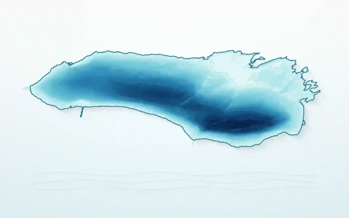
Lake Victoria is Africa’s largest lake by surface area. That does not make it Africa’s deepest lake or its largest store of water by volume. A broad, comparatively shallow basin can cover far more ground than a narrow, deep lake while holding less water.
The Nile Basin Initiative’s Water Resources Atlas (2016) lists a surface area of about 26,600 square miles (68,800 square kilometers). A later, high-resolution mapping and acoustic-survey project, published in Scientific Data in 2022, reports a mapped surface area of about 25,800 square miles (66,793 square kilometers). These are source-specific measurements, not two observations that by themselves demonstrate a decline in the lake.
| Measure | NBI atlas, 2016 | 2022 survey publication |
|---|---|---|
| Surface area | About 26,600 sq mi (68,800 km²) | About 25,800 sq mi (66,793 km²) |
| Mean depth | About 131 ft (40 m) | About 130 ft (39.77 m) |
| Depth statistic | Maximum depth listed as about 276 ft (84 m) | Deepest collected sounding: about 243 ft (74.12 m) |
The later project surveyed Lake Victoria during 2017–2020. Its authors define their maximum-depth statistic as the deepest sounding they collected. That is more specific than a claim to have located the deepest possible point anywhere in the lake, and it should be described accordingly.
Shoreline delineation, islands, measurement coverage and water-level reference all matter when comparing lake statistics. A study’s mapped area and a standard reference-table area are not interchangeable entries in a time series. Establishing actual change requires a consistent method and comparable observations, rather than subtracting whichever two published numbers are easiest to find.
The broad physical conclusion is much less uncertain: Victoria is enormous in surface extent but relatively shallow compared with deep rift lakes such as Lake Tanganyika. “Largest” needs its metric, and “depth” needs its measurement definition.
3. Why is Lake Victoria broad rather than extremely deep?
A depression between the rift branches
Lake Victoria occupies a broad depression between the eastern and western branches of the East African Rift System. It is not simply another long, narrow trough along the deepest part of a rift branch. That setting helps explain its wide outline and comparatively modest depth.
A 2024 report on the Lake Victoria Drilling Project describes uplift along the western rift branch as having reversed some formerly west-flowing drainage. Water backed up into the developing low area. Tectonic movement therefore matters to the lake’s origin, but calling it a typical deep rift-valley lake hides the difference between Victoria and lakes occupying more deeply faulted troughs.
It is also useful to separate the age of a basin from the continuity of the water inside it. Sediment evidence shows that Lake Victoria dried out at least once in the Late Pleistocene and subsequently refilled. An old basin does not necessarily mean an unbroken lake with the same outline and water level throughout its history.
Those past changes are part of why scientists study its sediments. Layers beneath the water preserve evidence of changing environments, while exposed deposits around the margin can record former landscapes. They are not a schedule for the next drying event, and a prehistoric change should not be presented as a forecast for a particular future year.
4. How does Lake Victoria connect to the Nile?
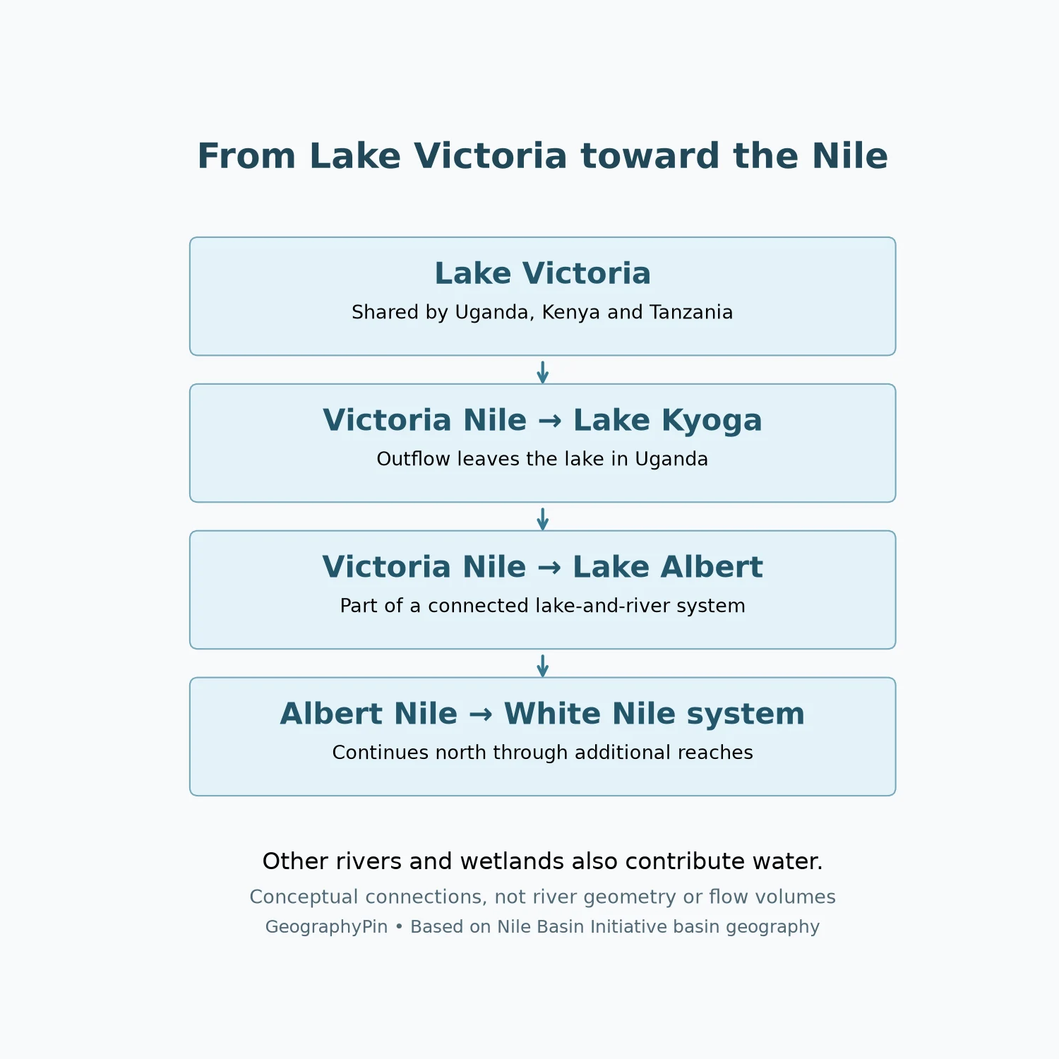
An important source lake, not the whole river’s only source
Water leaves Lake Victoria on the Ugandan side near Jinja and enters the Victoria Nile. The connected system passes through Lake Kyoga and reaches Lake Albert; downstream of Lake Albert, the Albert Nile continues north. These lakes and river reaches form part of the wider White Nile system.
This is why Victoria is often described as a source of the Nile. Yet the lake itself receives water from rainfall and rivers, and the Nile also receives major contributions from other branches. “The source” can mean the outlet of an important source lake, a distant upstream headwater, or the beginning of a particular named river reach.
The diagram keeps that distinction visible. It follows one lake-and-river connection without pretending that every tributary, wetland, dam or change of river name has been included. It also does not imply that the whole route is continuously navigable.
Lake storage affects how water moves through the system. Inflows do not all pass straight through on arrival: water is stored, lost by evaporation and released through the outlet. Downstream regulation adds another reason not to infer a discharge rate from the width of a line on a map.
5. Rain, evaporation and the lake’s daily weather
A large surface exchanges water and heat with the air
Lake Victoria’s water balance includes rain directly onto the surface, river inflows, evaporation and outlet flow. Because the surface is so extensive, atmospheric exchanges are a central part of its hydrology rather than a minor addition to the rivers. A wet or dry period can affect both direct rainfall and runoff from the surrounding catchment.
Water level is not the same measurement as water volume, and neither is identical to surface area. The relationship depends on the basin’s shape. A shoreline may move noticeably across gently sloping ground while changing less along a steeper margin; an outline on a general map cannot show those local responses precisely.
Why storms can form over the water at night
NASA’s account of Lake Victoria thunderstorms explains a recurring contrast between land and water. During the day, land heats faster than the lake. At night, the land cools more quickly while the water retains heat. Breezes can converge over the relatively warm lake, helping moist air rise and supporting thunderstorms.
This is a physical mechanism and a pattern seen in rainfall observations, not a promise that a storm will occur at the same hour every night. Season, wind and the larger weather situation still matter. A geographic explanation of lake breezes is not a substitute for a current marine-weather forecast.
The combination of a large open surface, surrounding terrain and tropical moisture makes weather part of the lake’s geography. It also shows why “shallow” is only a comparison with much deeper lakes: the water body remains large enough to influence its surrounding atmosphere.
6. Why the lake and the basin must be managed together
Fishing, settlements, transport and water use connect people to Lake Victoria, but many influences on the lake begin inland. Sediment and nutrients can move through tributaries; shoreline development and wastewater affect nearshore conditions; changing land cover can alter runoff. These processes do not stop at a national border or at the edge of a town.
The lake also supports a highly diverse fish fauna, including cichlids studied for their evolutionary history. Ecological claims need their own dates and definitions: a historical species estimate is not a current census, and a catch statistic is not a measure of all fish remaining in the water. The lake’s importance does not require an undated claim about how many people or fish it supports today.
The practical geographic lesson is to match the scale of the question. To locate a lakeside city, use a shoreline map. To understand where runoff originates, use a catchment map. To interpret a water-level record, check its reference datum and period. To compare lake size, keep the same metric and method.
That approach makes the lake easier to understand without turning it into a single superlative. It is a shared water body, a receiving basin, a source lake in a larger river network and an environment whose surface, atmosphere and surrounding land interact.
Frequently Asked Questions
Do Rwanda and Burundi border Lake Victoria?
No. They form part of its wider catchment, but the lake itself is shared by Uganda, Kenya and Tanzania.
Is Lake Victoria the deepest lake in Africa?
No. Its distinction is surface area. Lake Tanganyika is much deeper; the two lakes have different basin shapes and should not be ranked using different measurements.
Does a smaller published area prove the lake has shrunk?
Not by itself. Different shoreline datasets, mapping methods and water-level references can produce different areas. A change estimate needs comparable observations.
Is Lake Victoria the only source of the Nile?
No. It is an important source lake in the White Nile system, receives upstream inflows itself, and is only one part of the Nile’s wider network.
What Did We Learn Today?
Lake Victoria’s geography becomes clearer when the lake, its catchment and the Nile network are treated as related but different systems. Three countries share its shore, two more contribute to its wider catchment, and its broad basin is much shallower than the deep rift lakes. Reading measurements alongside their methods prevents differences between sources from becoming false claims about environmental change.
Sources & Data Notes
The statistics table compares the 2016 NBI reference atlas with the 2022 survey publication, which includes Lake Victoria observations from 2017–2020. Values are rounded for reading; they are not a consistent time series. The survey depth is its deepest collected sounding, not an independently established absolute deepest point. Original maps use Natural Earth’s generalized lake and country geometry, not the research paper’s bathymetric dataset. The flow diagram shows selected connections, not channel positions or discharge.