Lake Geneva, Wisconsin, is the city at the eastern end of Geneva Lake. The reversed names distinguish the municipality from the water beside it, while other communities occupy different parts of the lakeshore.
The lake and city distinguished
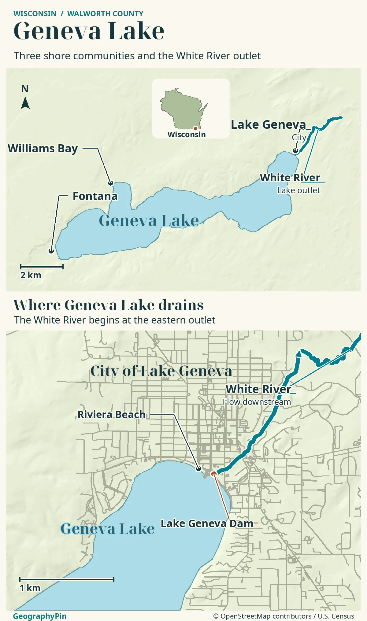
Geneva Lake is the Wisconsin water body; Lake Geneva is the city on its eastern and northeastern shore. Both lie in Walworth County. Williams Bay and Fontana are separate shore communities, and the White River carries water away at the eastern outlet. Neither name here refers to the Swiss–French lake.
How to use this article: separate the city label from the water, one municipality on a shared shoreline, read the lake’s size with its source, the lake continues into a river system.
Location, Names and the Map
Separate the city label from the water
In southeastern Wisconsin, Lake Geneva is a city and Geneva Lake is the water body beside it. Both are in Walworth County. The city occupies the lake’s eastern and northeastern shore; it does not surround the entire lake.
The word order is useful for distinguishing two neighbouring features, not evidence that there are two different lakes. Official municipal documents use City of Lake Geneva, while Wisconsin’s lake database lists Geneva Lake. Everyday searches can mix the two, so add “Wisconsin” and the feature you want.
This is not Europe’s Lake Geneva, also called Lake Léman, on the Swiss–French border. The Wisconsin lake lies southwest of Milwaukee and northwest of Chicago.
The most useful first question is therefore not “Where is Lake Geneva?” but “Do I need the city centre, a particular shore community or the lake itself?” Those searches lead to different points on the same map.
City of Lake Geneva
One municipality on a shared shoreline
The City of Lake Geneva is one community beside the water, rather than a collective municipal name for every shore settlement. The city’s comprehensive plan places Williams Bay and Fontana on Geneva Lake west of the city. They are separate villages, not neighbourhoods of Lake Geneva.
A further distinction is the Town of Geneva. In Wisconsin, “town” can identify a separate unit of local government, not merely a casual description of a city. Do not replace City of Lake Geneva with Town of Geneva when looking up a property or municipal service.
For practical orientation, keep the named municipality alongside the address. A business described as being in the wider Lake Geneva area need not be within city limits or beside the downtown waterfront. Check the actual destination before judging how close it is to a chosen landing, beach or accommodation.
The same principle applies to maps: a settlement marker locates a community, but it does not trace its legal boundary. Use the municipal map for a boundary question and the lake outline for a physical-geography question.
Geneva Lake Shore
Read the lake’s size with its source
Wisconsin DNR’s lake overview lists Geneva Lake at 5,401 acres, approximately 21.9 square kilometres, with a maximum depth of 135 feet, about 41 metres. These are lake measurements, not the area or elevation of the city.
There is a published difference in the area figures. The city’s comprehensive plan, amended October 27, 2025, describes a 5,262-acre lake, and the DNR dam record also uses 5,262 acres. Those sources agree on the 135-foot maximum depth. The records cited here do not establish why their area figures differ; the difference alone is not evidence that the lake recently grew or shrank.
| Record | Area stated | Maximum depth |
|---|---|---|
| DNR lake overview, WBIC 758300 | 5,401 acres | 135 feet |
| 2025 amended city comprehensive plan | 5,262 acres | 135 feet |
Depth is not uniform across that surface. A maximum describes the deepest recorded point, not the depth beside a beach, pier or outlet. For the shape beneath the water, use a bathymetric map rather than applying the maximum everywhere.
White River Outlet
The lake continues into a river system
The White River leaves Geneva Lake at its eastern end in the city. This outlet is a key feature that a simple blue lake polygon can conceal: the lake is connected to downstream water, not an isolated bowl with no exit.
Wisconsin DNR’s dam inventory locates the Geneva Lake dam at approximately 42.5900° N, 88.4351° W and identifies the associated stream as the White River. The structure belongs on an outlet close-up, rather than at the lake’s centre or beside Fontana.
The dam’s presence should not be used to describe the entire lake as an excavated reservoir. The city’s plan identifies glacial processes in the formation of the basin and surrounding landscape. A natural basin and a managed outlet can coexist.
The White River carries water eastward from the lake. That connection does not establish a permitted boating route through the dam or outlet.
Interpreting the Landscape
Compare shoreline, watershed and jurisdiction
Three boundaries matter here. The shoreline separates land from lake. A municipal boundary separates local-government areas. A watershed boundary describes the land draining toward a water system. These lines need not coincide.
That helps explain why lake management extends beyond the City of Lake Geneva. The Geneva Lake Environmental Agency is shared by the Towns of Linn and Walworth, the Villages of Fontana and Williams Bay, and the City of Lake Geneva. Its work concerns the lake and its watershed, not only the city’s waterfront.
A land-relief map helps explain the surrounding slopes and drainage. A bathymetric map instead shows depths below the lake surface. Neither is a substitute for a current access map or local instructions at a landing.
The DNR-linked contour sheet is a historical June 1967 lake map explicitly marked not for navigation. It is useful for understanding the basin’s broad form, but should not be treated as a current chart of obstacles, facilities or usable water depth.
Read the map according to the question: the locator for regional position, shore labels for destinations, depth contours for the underwater basin and official boundary mapping for jurisdiction. Keeping those purposes separate resolves most of the confusion created by the two reversed names.
Frequently Asked Questions
Which identifier helps when a water database reverses the words?
Use Wisconsin DNR waterbody identification code 758300 and Walworth County. DNR’s lake overview says Geneva Lake, while some water-detail headings use Lake Geneva. The identifier helps confirm that the records refer to the same Wisconsin water body.
Does a lakefront address guarantee access to every part of the shore?
No. A location beside the lake does not establish public access, parking or permission to use a pier. Check the particular destination and its current access information rather than interpreting a continuous shoreline on a map as a public route.
What Did We Learn Today?
Geneva Lake is the water, Lake Geneva is a city, and the wider shoreline includes other communities. The White River outlet connects the lake to downstream waters. Source-labelled measurements and separate shoreline, depth and jurisdiction layers make the map useful without turning it into an access or navigation promise.
Sources & Data Notes
- Wisconsin DNR: Geneva Lake overview, WBIC 758300
- City of Lake Geneva: amended comprehensive plan and maps
- Wisconsin DNR: Geneva Lake dam record
- Geneva Lake Environmental Agency: participating municipalities and remit
- Wisconsin DNR: historical lake contour map
- Wisconsin DNR: water-detail record and monitoring identifiers
Sources checked November 19, 2026. The DNR overview’s 5,401-acre figure differs from 5,262 acres in the amended city plan and dam record; the cited records do not explain the difference. Metric figures are rounded conversions. The June 1967 contour map is historical and explicitly not for navigation.
Map: GeographyPin original atlas. Lake outline, waterways, dam and places © OpenStreetMap contributors, ODbL, retrieved November 19, 2026. Wisconsin locator from U.S. Census Bureau 2025 cartographic boundaries; relief from Mapzen/AWS Terrain Tiles and underlying sources. No municipal boundaries or navigation routes are shown.
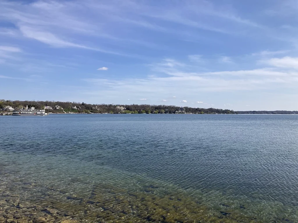
Photograph: Geneva Lake, April 26, 2025, Michael Barera, CC BY-SA 4.0. Resized and converted to WebP, without cropping or retouching.