Higgins Lake combines broad, shallow-looking shore water with much deeper offshore basins. Its islands add another layer of confusion: a place called Treasure Island in local material appears as Flynn Island in the federal names database. Understanding the lake means matching those names to the physical landscape without treating a map label as permission to land.
Higgins Lake is a natural, glacially formed freshwater lake in Michigan’s Lower Peninsula, mostly in Roscommon County. Its northern basin contains the island commonly called Treasure Island, recorded as Flynn Island in USGS geographic names data. North and South Higgins Lake state parks provide established public access, distinct from access to island property.
1. Where is Higgins Lake?
A Lower Peninsula lake, not one of the Great Lakes
Higgins Lake lies in Michigan’s central Lower Peninsula, mainly in Roscommon County with a small northern part in Crawford County.
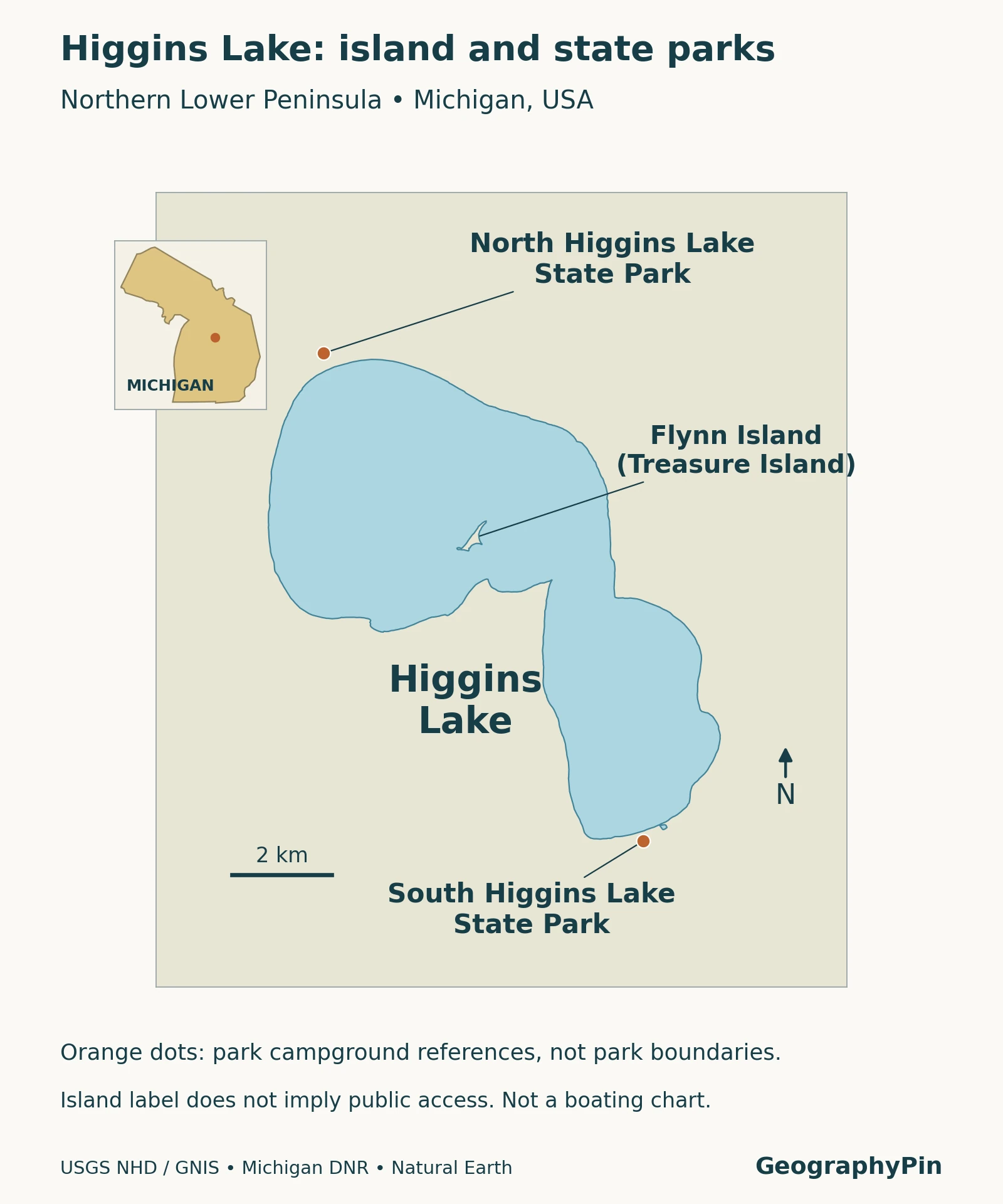
The map locates the two state parks and the island discussed below. Park symbols are reference points, not surveyed park boundaries. The lake outline shows the waterbody, not underwater contours or a route around shallow areas.
Nearby Marl Lake and Houghton Lake are separate waterbodies. Their connection to Higgins Lake is a drainage relationship, not an alternative naming system. A photograph or recreation listing for one should not automatically be used to describe the others.
2. Size, depth and the meaning of clear water
Use a dated measurement source
| Measure | Reported value | Interpretation |
|---|---|---|
| Surface area | 10,186 acres (41.22 km²) | Waterbody area in the DNR fisheries report. |
| Maximum depth | Approximately 135 feet (41.1 m) | Deepest reported water, not typical shoreline depth. |
| Average depth | 30.4 feet (9.3 m) | A lake-wide average, not a depth at a specific location. |
Values follow DNR’s 2021 report, not a new bathymetric survey.
Clear water describes visibility, not uniform depth. Sunlight reaching a pale lakebed can make nearshore water look very different from the darker offshore surface. Color also changes with lighting, wind and viewing angle. A photograph therefore cannot replace a depth chart, water-quality result or current swimming notice.
3. Glacial origin and a connected water system
Follow the outlet beyond the lake
Higgins Lake drains southward into Marl Lake; the Cut River continues from there toward Houghton Lake. These waters belong to the Muskegon River system. The outlet has a lake-level control structure, but the basin itself is natural.
USGS research covering 1995–99 examined groundwater and nearshore water quality around Higgins Lake. It identified groundwater as a major part of the lake’s water supply, emphasizing that important movement occurs beneath the land surface as well as through visible streams. Those historical findings should not be presented as a newly measured percentage of today’s water budget.
A lake’s catchment is the land that drains toward it, while groundwater follows subsurface pathways that require their own investigation. The visible shore is consequently not the full boundary of processes affecting the water. Development away from a beach can still be relevant to a lake, even if no large stream is visible between the two.
For a broader explanation of natural basins and managed waterbodies, see what is a lake? An outlet dam and a natural lake can coexist; neither a dam symbol nor a wooded shoreline alone explains the origin of the entire basin.
4. Treasure Island and Flynn Island
Match the names before matching the photograph
A USGS water-quality report labels Treasure Island on Higgins Lake in the northern basin; the federal geographic names record identifies the same island as Flynn Island. The two names appear in different source contexts.
The Higgins Lake Land Conservancy also uses Treasure Island in its own account of a loon-preservation property. This provides a locally grounded reference alongside official mapping. It does not establish that every island photograph found online depicts this island, or that the entire island is a public recreation area.
In September 2019, the conservancy described acquiring a parcel on the southwestern part of the island for a loon sanctuary; its December 2025 newsletter continued to identify that preserve among its conservation projects. The stated purpose is habitat protection. The publication of a preserve name is not an invitation to use a private dock, walk across adjoining land or approach nesting birds.
Use the map for identification, not landing instructions. Confirm permission with the relevant owner or manager before going ashore, and keep away from sensitive wildlife habitat. No public landing route or parcel boundary is implied by the island label.
5. Established public access at the state parks
North and south are different starting points
North Higgins Lake State Park is on the northern shore. Its official listing includes a campground, boating access, a designated swimming beach, picnic facilities and trails. The park also contains the Higgins Lake Nursery and CCC Museum, connecting recreation with Michigan’s forestry and conservation history.
South Higgins Lake State Park provides another established approach to the lake, with a boat-access facility and day-use shoreline. The park’s setting also includes Marl Lake across County Road 100. DNR distinguishes that smaller lake’s nonmotorized and electric-motor boating opportunities from the facilities serving Higgins Lake itself.
These official facilities are better starting points for an unfamiliar visitor than an unverified roadside opening or an island pin. Check the relevant park page for current access arrangements, recreation requirements and notices. A geographic overview does not confirm that a campground site, parking space or particular facility is available on your chosen date.
6. Planning around a real lake, not just a scenic image
Decide first whether your visit is for a designated swimming area, a boat launch, camping or a walk in a state park. Each activity has a different starting point and different requirements. The island’s name may explain a photograph, but it is not a substitute for choosing a permitted access location.
Keep depth, clarity and safety separate. A visible bottom near a beach says nothing about the depth farther offshore, while a calm image says nothing about wind later in the day. The same caution applies in winter: a frozen-looking surface or a history of ice fishing does not establish safe ice conditions for a particular trip.
Finally, distinguish older research from current notices. A dated fisheries or groundwater report explains the lake’s physical and ecological setting. Park updates and local warnings serve a different purpose. Reading both at the right scale gives a more useful picture than treating a single statistic, map or photograph as the whole story.
What Did We Learn Today?
Higgins Lake is a natural inland lake whose shallow-looking margins and deeper basins should not be confused. Treasure Island and Flynn Island occur in different source records for the mapped northern-basin island. Identifying that feature does not establish landing rights: the state parks provide distinct, established public facilities, while conservation land and other shoreline property require their own access checks.
Sources & Data Notes
The measurement table follows the dated DNR report, not a new survey or a current lake-level reading. Groundwater findings are identified by their historical study period. The map uses generalized hydrography and reference points rather than ownership boundaries, underwater navigation detail or permission to land. Access information should be checked with the responsible park, owner or manager before a visit.
- Michigan DNR, Higgins Lake fisheries report, 2021. Physical reference measurements and drainage context.
- USGS: Effects of Residential Development on the Water Quality of Higgins Lake, Michigan, 1995–99. Historical groundwater research and a map naming Treasure Island.
- USGS Geographic Names Information System. Flynn Island record, feature ID 626203.
- Roscommon County agenda packet, February 25, 2026. Includes earlier MSU lake-survey material identifying Treasure Island; the packet date is not the underlying survey date.
- Higgins Lake Land Conservancy: Loon Preserve, September 2019 and December 2025 newsletter. Preserve purpose and continued identification, not a public-landing authorization.
- Michigan DNR: North Higgins Lake State Park and South Higgins Lake State Park. Facility context and current visitor information.
- USGS National Hydrography and Natural Earth. Original map geometry; park reference points from DNR.
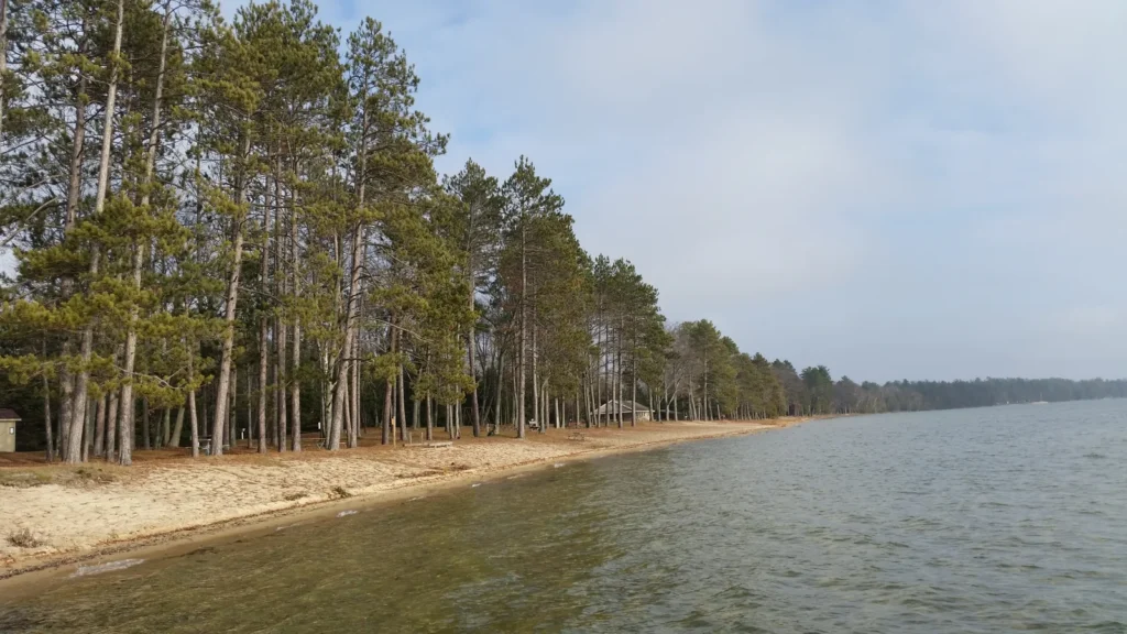
Featured photograph: Notorious4life / Wikimedia Commons, CC0. North Higgins Lake shoreline; resized and converted to WebP. This is a shoreline view, not a photograph of Treasure Island.