Lake Chelan is a long, glacier-carved lake in Washington state, stretching from Stehekin in the North Cascades to the city of Chelan. Its deep Lucerne Basin extends below sea level even though the lake surface stands far above it.
A high lake surface above a deeply carved floor
Lake Chelan occupies an overdeepened glacial valley in north-central Washington. Its northwestern Lucerne Basin is much deeper than the southeastern Wapato Basin, and its floor lies below sea level. Water leaves at Chelan through the Chelan River system to the Columbia, rather than draining from the lake’s deepest point.
How to use this article: Separate the lake, city and river, compare the depth figures and follow the outlet.
Lake Chelan on the map
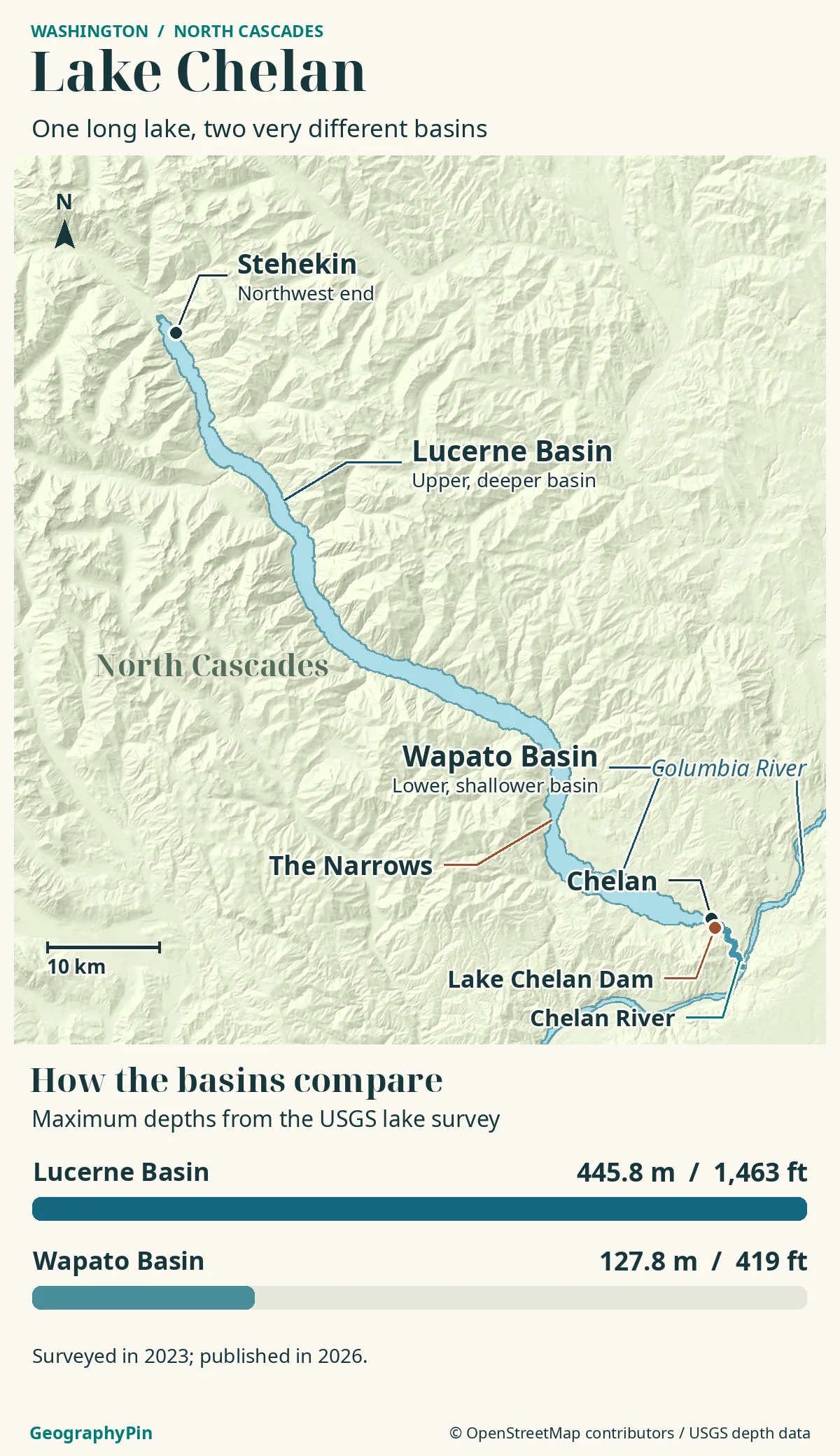
Lake Chelan occupies a long, narrow mountain valley in north-central Washington state, on the eastern side of the North Cascades. Its axis runs broadly northwest to southeast. Stehekin is at the northwestern head; the city of Chelan and the lake outlet are at the southeastern end.
The lake, the city and the river
“Chelan” can mean the city, while “Lake Chelan” means the much larger water body stretching into the mountains. The Chelan River is the short outlet downstream from the lake, not another name for its entire length. Chelan County PUD describes the lake as 50.4 miles (about 81 km) long.
Stehekin at the head of the lake
Stehekin anchors the upper end of the lake, where the Stehekin valley opens toward the water. It is a different kind of destination from the road-connected city of Chelan. The National Park Service states that no road connects Stehekin to the rest of Washington: visitors arrive by boat, aircraft or on foot.
Local roads in the valley do not contradict that statement. A road drawn beside Stehekin on a detailed map is not evidence of a continuous drive from Chelan along the lakeshore.
Stehekin is also a gateway to Lake Chelan National Recreation Area and the wider North Cascades landscape. The lake and the protected area are not interchangeable names. NPS guidance checked November 19, 2026 warns of limited services. Check its current Stehekin and flood-response information before arranging transport or accommodation.
The deep Lucerne Basin and shallower Wapato Basin
Lake Chelan is not a uniformly deep trench. The northwestern Lucerne Basin is substantially deeper and narrower than the southeastern Wapato Basin. A submerged sill at The Narrows separates them, while water still connects the two.
A newer survey changes the quoted maximum
A USGS map published in September 2026 reports a maximum measured depth of 445.8 m, about 1,463 ft, in Lucerne Basin, based on a 2023 multibeam survey. It explicitly contrasts this with the previously reported 453 m, or about 1,486 ft. Its Wapato Basin maximum is 127.8 m, about 419 ft.
The older 1,486-foot figure remains common in descriptions of the lake. It should not be presented as the result of the newer survey, nor should the difference be treated by itself as evidence that the lake suddenly became shallower. Survey methods, coverage and reference levels matter when comparing depth measurements.
How the lake floor can be below sea level
The key is to separate water depth from elevation. Depth measures downward from the water’s surface. Elevation measures a position against a vertical reference such as sea level. A lake can have an elevated surface and a bottom below that reference if its basin is deep enough.
Washington Geological Survey describes repeated glaciation carving the Lake Chelan valley. Moving ice can excavate an overdeepened basin: a hollow much deeper than the route by which water now leaves it. After the ice retreats, the lake fills that hollow. Its lowest floor need not be level with its outlet.
For a rounded illustration, a surface near 1,100 ft (335 m) above sea level and a depth of roughly 1,460 ft (445 m) put the bottom roughly 360 ft (110 m) below sea level. This subtraction explains the geometry; it is not a precise surveyed bottom elevation. Lake level changes, and exact calculations require matching vertical references.
There is no need for an underground connection to the ocean. The deep hollow holds freshwater while the outlet remains above sea level. “Below sea level” describes elevation, not saltwater or a hidden coastal inlet.
The Chelan River outlet and Columbia connection
Follow the water southeast
The outlet is beside the city of Chelan at the southeastern end, beyond the shallower Wapato Basin. From there the Chelan River runs to the Columbia River. Washington’s Department of Ecology describes the river as about 4 miles (6 km) long.
Hydropower adds a second route for water: an underground power tunnel connects the dam with the powerhouse at Chelan Falls. That engineered route should not be confused with the surface river on a map. Both belong to the lake’s downstream connection with the Columbia system.
Older descriptions sometimes call the Chelan River normally dry. Ecology’s 2021 technical report explains that minimum instream flows were implemented in 2009, restoring consistent year-round flow. The river is not simply a dry line that carries water only when the dam spills.
Nor is that line a suggested recreation route. Chelan PUD restricts public access within the river project area apart from designated exceptions. Use identified public facilities and current access guidance rather than following a drainage arrow into the gorge.
Reading the landscape above and below the water
The long lake outline reveals the valley’s direction, but not its full relief. A map of underwater terrain, called bathymetry, adds the basin floor, submerged slopes and deltas that are invisible from shore.
USGS’s 2026 account of the 2023 mapping describes numerous underwater deltas and deposits left by slope failures. The lake floor is therefore more complicated than a smooth bowl. It records material delivered from surrounding slopes as well as the older glacial excavation.
A useful lake map keeps three ideas separate: the real horizontal shoreline, underwater depth, and the river’s downstream course. A conceptual side view can explain why the bottom lies below sea level, but should not pretend to reproduce a measured profile. A boat-navigation chart is a separate tool again.
Frequently Asked Questions
Is Lake Chelan entirely artificial?
No. Its glacial basin predates modern hydropower. The dam now regulates the natural lake’s water level, so calling it a reservoir describes its present management rather than the origin of the whole basin.
Does the lake stay at the same level all year?
No. Chelan PUD manages a varying level in response to runoff, operating requirements and other conditions. Its lake-level page, rather than a fixed elevation printed on an overview map, is the place to check current readings and forecasts.
What Did We Learn Today?
Lake Chelan’s deep floor is the result of glacial excavation, not an ocean connection. Stehekin marks the upper end; the shallower Wapato Basin leads toward Chelan and the Columbia drainage system. The newer USGS survey also makes it important to distinguish a dated depth measurement from the familiar older figure.
Sources & Data Notes
The basin depths come from USGS Scientific Investigations Map 3559, published in 2026 from 2023 observations; feet are rounded conversions. Washington Geological Survey explains the glacial origin, while Chelan PUD and Washington’s Department of Ecology document water management and the outlet. The sea-level subtraction is a deliberately rounded explanatory example, not a geodetic calculation. NPS guidance supplies the Stehekin access distinction. Sources were checked November 19, 2026.
- USGS: 2026 bathymetric map publication and basin depths
- USGS: the 2023 lake-floor mapping
- Washington Geological Survey: Lake Chelan geology
- Chelan PUD: dam, lake length and power tunnel
- Chelan PUD: lake levels and access restrictions
- Washington Department of Ecology: Chelan River technical report, 2021
- National Park Service: Stehekin
Map: GeographyPin original atlas using Lake Chelan, Columbia River/Lake Entiat, mapped dam and connected river centerline from OpenStreetMap, retrieved November 19, 2026. © OpenStreetMap contributors, ODbL. Relief from Mapzen/AWS Terrain Tiles and underlying elevation sources. Bars compare USGS survey maxima; the map does not plot the exact deepest point or underwater contours. The Narrows marks the approximate surface constriction, not a surveyed sill contour. River lines are not recreation routes.
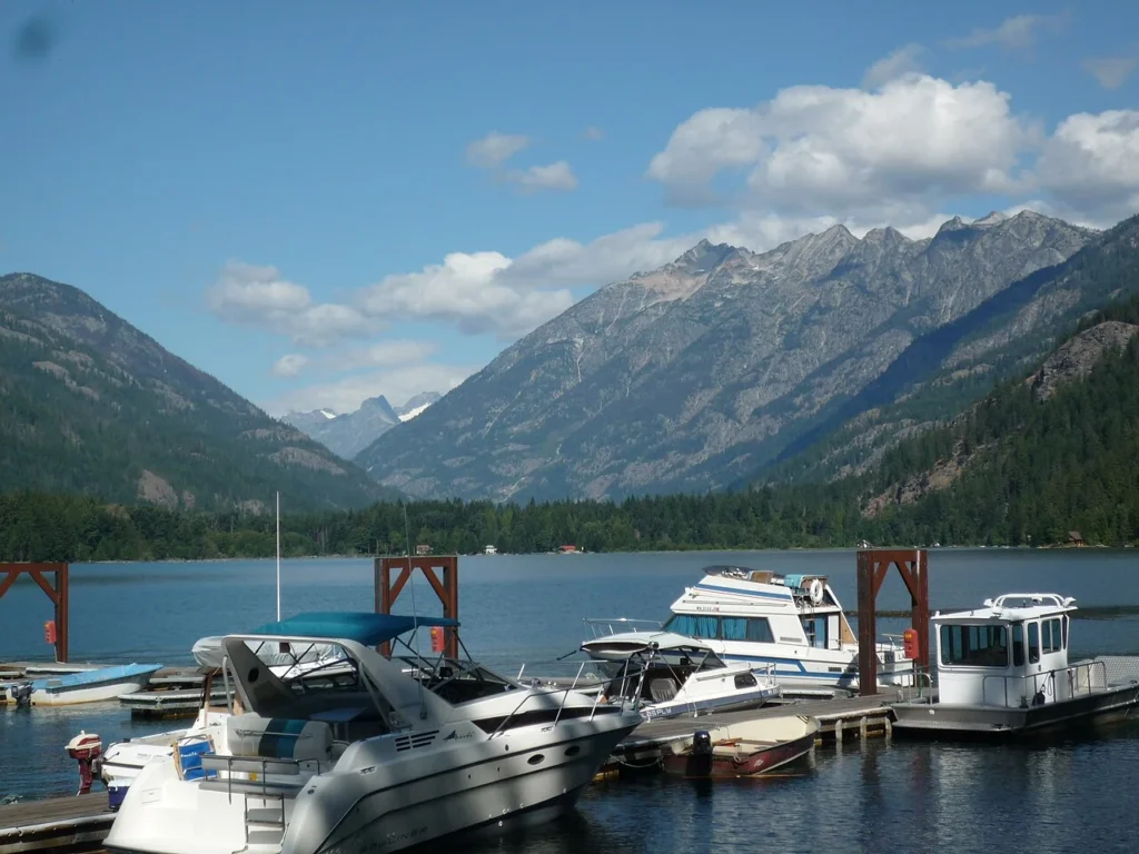
Photograph: Lake Chelan, McGregor Mountain, Maurice King, August 16, 2009, CC BY 2.0. Resized and converted to WebP.