The water beside downtown Lake Placid is Mirror Lake, not the larger lake named Lake Placid. The larger Lake Placid lies immediately to the north, and the village shares its name with that larger waterbody. A map makes this much easier to understand than a list of attractions.
Lake Placid is both a lake and a village in New York’s Adirondacks. Mirror Lake is a separate, smaller lake beside the village’s Main Street. The larger Lake Placid has a more complex shoreline and islands. Distinguishing the two lakes matters when interpreting photographs, comparing measurements or choosing the correct boat launch.
1. Where is Lake Placid?
Two lakes and one familiar village name
Lake Placid is in Essex County in northeastern New York State, within the Adirondack region. The village is in the Town of North Elba. In New York, “town” and “village” are administrative terms; they should not be treated as interchangeable labels for every named destination.
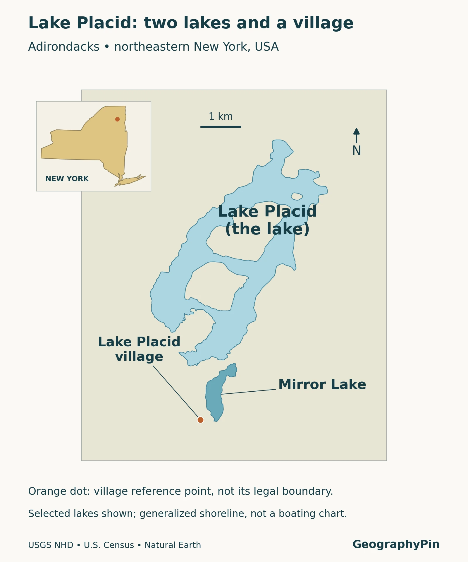
On this map, the larger, branching waterbody is Lake Placid. Mirror Lake is the smaller lake directly to its south. The village reference point marks the settlement for orientation, not its legal boundary. The two water polygons are separate features, not alternative names for a single lake.
This also explains a common photographic mix-up. A view across water from the Main Street area can be a view of Mirror Lake even when its caption describes a holiday in Lake Placid. The destination name is not necessarily the name of the water in the picture.
2. Comparing Lake Placid and Mirror Lake
Read the source behind each number
| Measure | Lake Placid | Mirror Lake |
|---|---|---|
| Surface area | 1,992 acres (8.06 km²), July 2022 management plan | 128 acres (0.52 km²), DEC lake map; survey date not stated |
| Mean depth | 52 feet (15.8 m), 2022 plan | 14 feet (4.3 m), DEC map |
| Maximum depth | 151 feet (46.0 m), 2022 plan | Not stated in the DEC reference used here |
| Main geographic distinction | Larger lake north of Mirror Lake, with islands and several basins | Smaller lake beside downtown and Main Street |
Published Lake Placid area figures differ. DEC’s McKenzie Mountain Wilderness page gives 2,173 acres (8.79 km²), while the July 2022 management plan gives 1,992 acres. The table preserves the plan’s figures together rather than silently combining incompatible measurements. The sources consulted do not establish the reason for the difference; it should not be attributed to islands or a changed water level without evidence.
Mean depth describes a lake-wide average, whereas maximum depth is the deepest reported point. Neither tells you the depth at a particular swimming or launching location. These reference figures are also not a navigation chart or a new survey made for this article.
3. A lake landscape shaped by ice and drainage
Natural formation and later water-level control
The 2022 management plan identifies Lake Placid as a glacial drainage lake and describes deposits left as ice retreated near its outlet. It is a natural lake whose outlet was later modified by a dam, not a reservoir created wholly by flooding a previously dry valley. Its water drains through Outlet Brook and the Chubb River into the West Branch Ausable River.
That distinction avoids an overly simple natural-versus-artificial classification. A lake can have a natural origin while its present outlet is managed. For the broader terminology, see what is a lake?
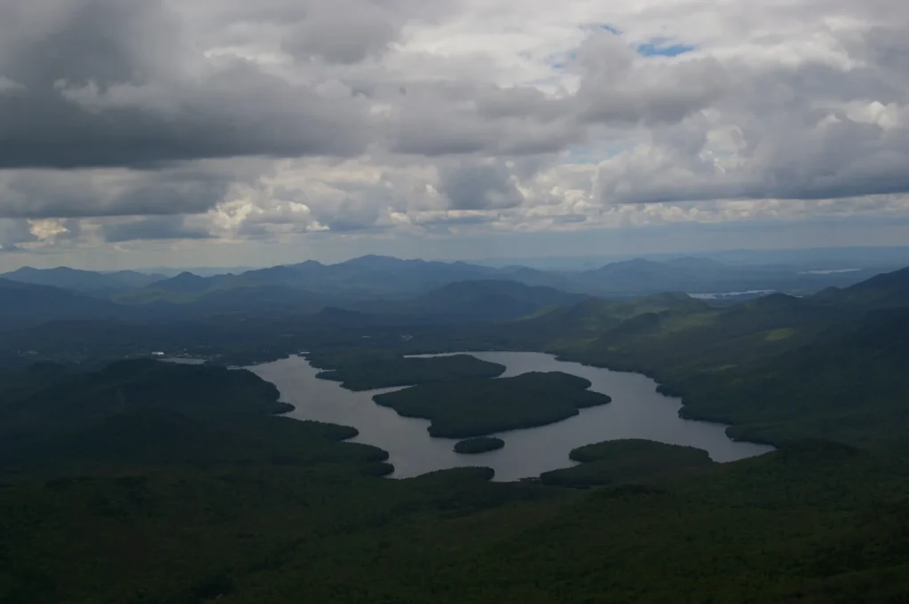
The outline also matters. Islands and narrow passages divide the larger lake visually into different stretches of water. A single photograph from one bay cannot represent every shoreline, and a flat locator map does not describe underwater slopes. Use the map to identify the waterbody, then consult the appropriate detailed chart or local information for an activity.
4. Why the village is internationally known
The Olympic name refers to the host destination
Lake Placid hosted the Winter Olympic Games in 1932 and 1980. The New York State Olympic Regional Development Authority records both editions in its event history. The name therefore appears in sports coverage and travel writing far beyond discussions of the lake itself.
Olympic venues are not all located on the shore of the larger lake. The authority’s regional venue network includes the Olympic Center, the Olympic Jumping Complex, Mount Van Hoevenberg and Whiteface Mountain. A search for an Olympic venue should use that venue’s actual location rather than a generic lake pin.
This is a useful way to read the destination: the village is a settlement and service center, the lakes are physical features, and the sports facilities form a wider regional network. They overlap in visitors’ experience but are not identical geographic units. The lake map is intended to clarify those names, not replace a venue map or current event schedule.
5. Which lake does the boat launch serve?
Nearby access points, different waterbodies
DEC’s Essex County launch directory lists separate entries for Lake Placid and Mirror Lake. The Lake Placid entry is a hard-surface launch; Mirror Lake’s is a hand launch with a short carry. Their proximity makes it especially important to check which side and which lake your chosen access serves.
The same directory describes Mirror Lake’s launch as electric motors only. That is more precise than saying every kind of motor is banned. Read the current agency listing and applicable rules for your vessel before launching; the geographical comparison here does not replace detailed regulations or operating notices.
DEC also distinguishes Lake Placid, which borders McKenzie Mountain Wilderness, from waters inside the wilderness. Do not automatically transfer a rule for interior wilderness waters to every adjacent lake. Conversely, a launch does not establish unrestricted access across surrounding private shoreline land.
For present arrangements, use the official Essex County launch directory. Its location information helps identify the facility, but a listing is not a guarantee of available parking, unobstructed access or suitable water conditions when you arrive.
6. Reading the landscape in different seasons
The lakes’ identity stays the same through the seasons even when their appearance changes. A leaf-covered shoreline, snow or a frozen surface can obscure the landmarks used to identify a photograph. Start with the relative size and position of the two waterbodies, then compare the shore and settlement features rather than relying on a caption alone.
Winter-sports history is not evidence that natural lake ice is safe on a particular date. Nor does a promotional photograph establish today’s conditions. Use current local notices and the guidance of the organization responsible for the activity you plan; do not infer ice safety from the month, a weather forecast or the presence of other people on the surface.
For a first visit, decide whether you want to see the village waterfront, explore the larger lake or visit a particular sports venue. Those choices lead to different locations. Keeping Mirror Lake, Lake Placid and the village separate on the map is the simplest way to avoid starting in the wrong place.
What Did We Learn Today?
Lake Placid the lake, Mirror Lake and Lake Placid village are three related but distinct places. Downtown waterfront views commonly show Mirror Lake, while the larger Lake Placid lies to its north. Their measurements and launch facilities should not be mixed, and a village reference point is not a legal boundary. Matching the name to the map is the foundation for understanding the destination.
Sources & Data Notes
The comparison table attributes measurements to their published sources; it is not a new survey. The differing Lake Placid area figures remain explicitly attributed rather than reconciled speculatively. Access references were consulted in November 2026; use the responsible agency for current rules and conditions. The original map shows generalized waterbody outlines and a settlement reference point, not bathymetry, property rights or a surveyed municipal boundary.
- Lake Placid Lake Management Plan, July 2022. Adirondack Watershed Institute, Ausable River Association and Shore Owners’ Association research; physical measurements and formation/drainage context.
- New York DEC: McKenzie Mountain Wilderness. Alternative published area and the distinction between bordering and interior waters.
- New York DEC: Mirror Lake map. Area and mean depth; no survey date stated in the reference.
- New York DEC: Essex County launch directory. Separate Lake Placid and Mirror Lake facilities and listed launch restrictions.
- New York State Olympic Regional Development Authority: History of Events. Winter Olympic host years and regional venues.
- Regional Office of Sustainable Tourism: Mirror Lake. Visitor orientation and village waterfront context.
- USGS National Hydrography, U.S. Census Gazetteer files and Natural Earth. Original map waterbodies, 2025 village reference point and state context.
Featured photograph: Swatigsood / Wikimedia Commons, original photograph dedicated to the public domain. Lake Placid viewed from Whiteface Mountain, May 2010; resized and converted to WebP.