La Paz is the administrative capital of Bolivia and the highest capital city in the world, perched roughly 3,650 meters (11,975 feet) above sea level. This Andean city serves as Bolivia’s seat of government and is known for its thin air, dramatic mountain backdrop, and vibrant cultural scene.
Geography and Elevation
Setting and Location
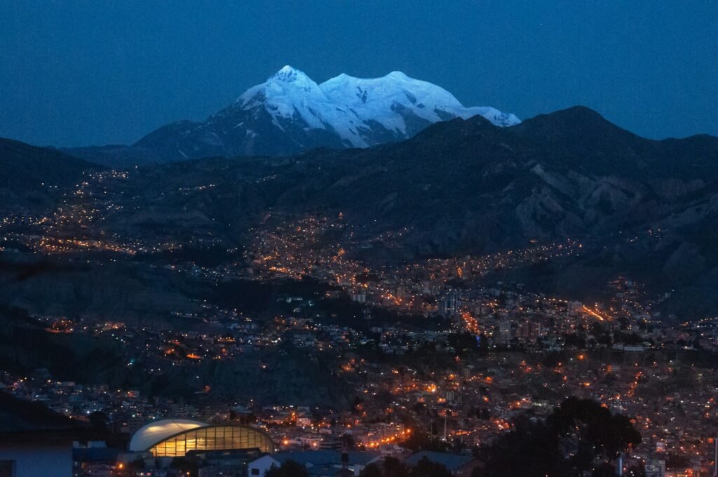
La Paz is nestled in a high-altitude valley in west-central Bolivia, about 42 miles (68 km) southeast of Lake Titicaca. The city sits in a bowl-like canyon carved by the Choqueyapu River, surrounded by the broad Altiplano plateau and Andean peaks. Overlooking La Paz is the triple-peaked Mount Illimani (elevation 6,438 m or 21,122 ft), snow-capped year-round and dominant on the skyline.
Altitude and Climate
At approximately 3,650 m (11,975 ft) above sea level, La Paz holds the title of the highest national capital on the planet. Its elevation sits far above any other capital city and inspires the nickname “city in the clouds.” For newcomers, climbing a flight of stairs can feel like a workout due to the thin atmosphere.
At this altitude the air has about 30% less oxygen than at sea level, so visitors and recent arrivals often need time to acclimate. The climate stays cool year-round: days are mild (generally around 59°F to 68°F, or 15–20°C) and nights turn cold, often near freezing. Despite lying just 16° south of the equator, the high elevation keeps temperatures comparable to far northern climates.
The city experiences a rainy summer (roughly November–March) and a dry winter.
City Layout and Microclimates
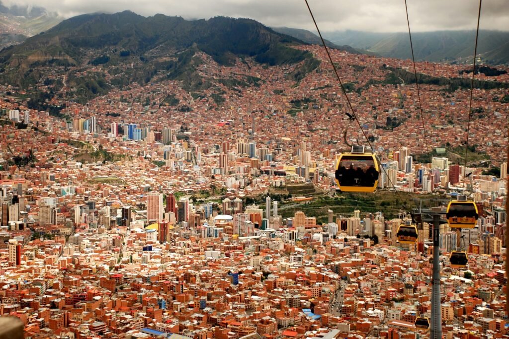
Elevation varies within the urban area. Lower neighborhoods in the southern valley (e.g., Zona Sur at ~3,250 m) enjoy slightly warmer conditions. The adjacent city of El Alto, spread across the plateau at 4,000–4,150 m (13,100+ ft), is colder and has thinner air.
Being in a sheltered valley about 1,400 feet (430 m) below the rim of the Altiplano helps central La Paz avoid some harsh highland winds. It also means the city has expanded up the steep canyon walls over time.
| Metric | Value |
|---|---|
| Elevation (city center) | ≈3,650 m (11,975 ft) above sea level |
| Highest Point (El Alto area) | ≈4,100 m (13,450 ft) |
| Population (2024, city) | 755,732 inhabitants |
| Population (2024, metro) | ~2,200,000 inhabitants |
| Area (city proper) | 472 km² (182 sq mi) |
| Founded | 20 October 1548 (by Alonso de Mendoza) |
| Capital status | Seat of government since 1898 (constitutional capital: Sucre) |
Historical Background
Indigenous Roots and Spanish Foundation
The area of La Paz was originally home to Indigenous settlements — it lies on what was once an Inca village known as “Chuqi Yapu” or Chuquiago. Spanish conquistadors, led by Captain Alonso de Mendoza, founded the city on October 20, 1548.
It was first established at a site called Laja, then moved a few days later to the present valley of Chuquiago Marka for a milder climate and better resources. Mendoza named the city Nuestra Señora de La Paz (“Our Lady of Peace”) to commemorate the restoration of peace after a civil rebellion in Peru. During colonial times, La Paz was part of the Spanish Viceroyalty of the Río de la Plata and grew as a commercial stopover between the silver mines of Potosí and the Peruvian coast.
Revolts, Independence, and Dual-Capital Status
La Paz has a strong history of political activism and upheaval. In 1781, Indigenous leader Túpac Katari led a months-long siege seeking to oust Spanish rule. Later, on July 16, 1809, local patriot Pedro Domingo Murillo launched a revolt remembered as one of Latin America’s first cries for independence. Murillo’s uprising is honored annually on La Paz Day.
These events helped spark the broader Spanish American wars of independence, which led to Bolivia’s freedom in 1825. After independence, the city’s name was briefly extended to “La Paz de Ayacucho,” honoring the decisive battle that ended Spanish colonial control.
By the late 19th century, La Paz had eclipsed Sucre in economic and political weight. A civil war in 1898 made La Paz the seat of the national government — effectively the administrative capital — while Sucre remained the constitutional capital, retaining the Supreme Court. This dual-capital arrangement persists: Sucre holds the judiciary; La Paz hosts the executive and legislative branches.
20th Century to Present
Throughout the 20th century, La Paz grew and modernized. It experienced political instability at times, yet asserted itself as Bolivia’s hub of commerce and culture.
Life at High Altitude (Culture and Society)
Indigenous Traditions and Daily Life
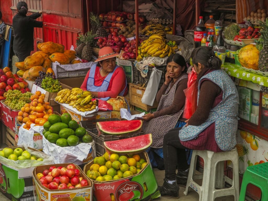
Life in La Paz is deeply influenced by Aymara and Quechua heritage alongside Spanish colonial legacy. Many residents are of Aymara descent, and their traditions shape daily culture. It’s common to see cholitas — Aymara women in traditional dress — in bowler hats, layered pollera skirts, and shawls.
Once marginalized, cholitas are now icons of paceño identity, even starring in local cholita wrestling events. Markets are central to city life. The most famous is the Witches’ Market (Mercado de las Brujas), where vendors sell medicinal herbs, dried llama fetuses, and other remedies used in Aymara spiritual ceremonies. Locals sip coca tea — an age-old remedy that helps people cope with thin air. Coca leaf tea and chewing are legal and culturally embedded, believed to ward off fatigue and altitude sickness.
Landmarks, Museums, and Festivals
La Paz is a city of contrasts, where modern life mingles with ancient traditions. In the center, colonial landmarks like the Basilica of San Francisco (18th century) and the Metropolitan Cathedral by Plaza Murillo stand beside newer office towers.
Plaza Murillo is the historic heart, home to the Presidential Palace and Congress, and often filled with pigeons and sun-seekers. Nearby, cobbled Calle Jaén preserves bright colonial houses that host museums of art, ethnography, and local history. The city’s cultural scene includes the National Museum of Art, the Museum of Ethnography and Folklore, theaters, and folk-music venues. Festivals are frequent and vibrant — from the Gran Poder parade with elaborate costumes to the Alasita fair where people buy miniature goods for luck.
Despite the altitude, nightlife and dining flourish. You’ll find street snacks and high-end restaurants serving Bolivian and international cuisine.
Sports, Cable Cars, and Outdoors
Sports and recreation come with a high-altitude twist. The main football stadium, Hernando Siles, sits at about 3,600 m — so high that visiting teams often struggle with the thin air. FIFA once briefly considered altitude limits for official matches, a move later lifted in part due to its impact on Bolivia’s home games.
Many locals stay active by necessity, climbing steep streets daily. On weekends, families ride cable cars to El Alto for panoramic views or head to mountain trails. The surrounding Andes offer hiking and mountaineering. Climbers use La Paz to acclimatize before peaks like Huayna Potosí or Illimani. In daily life, paceños adapt with resilience — not many city-dwellers can claim to live among the clouds.
Economy and Infrastructure
Economic Profile and Trade
As the administrative capital and a major economic center, La Paz punches above its weight in Bolivia’s economy. The metro area generates roughly a quarter of national GDP thanks to government institutions, finance, and industry. Key sectors include food processing, textiles and clothing, consumer goods, and telecommunications.
The city’s elevation once made heavy industry challenging, yet it thrives in commerce and services. La Paz is also capital of the surrounding department, serving as a marketplace for Altiplano goods (agricultural produce and handicrafts) and a distribution point for imports from the Pacific coast. Historically, its location controlled routes between mineral-rich highlands and the coast. Today, highways connect La Paz to ports in Peru and Chile and to other Bolivian cities. Overland routes link La Paz to the Peruvian border (and onward to Cusco) and to Chile’s Arica port, facilitating trade for landlocked Bolivia.
Mi Teleférico: A Subway in the Sky
The high altitude poses unique infrastructure challenges, and La Paz has innovated. El Alto International Airport sits on the plateau above La Paz at over 4,060 m (13,320 ft) — among the highest international airports in the world. Planes require longer takeoff runs in thin air, and engines need special calibration.
Urban transport long relied on steep roads plied by minibuses and taxis. Congestion and sharp terrain made commuting difficult. That changed in the 2010s with Mi Teleférico, an aerial cable-car transit system. As of today, Mi Teleférico is the highest and longest urban cable-car system in the world. The bright gondolas glide over the city, linking La Paz with sprawling El Alto in minutes. Opening in 2014 with three lines, the network expanded to 10 lines by 2019, earning a Guinness World Record for the largest public-transit cable-car network. This “subway in the sky” cut travel times, eased road traffic, and became a tourist attraction.
Engineering Challenges and City Solutions
Many neighborhoods cling to hillsides, so engineers build terraced roads and retaining walls to manage steep grades. Public works mitigate natural hazards, as heavy summer rains can trigger mudslides on deforested slopes.
Water supply is another focus. Glacial meltwater historically fed La Paz, but climate change has shrunk nearby glaciers, prompting new management strategies. Despite challenges, the city continues to modernize. Shopping centers and telecom networks coexist with traditional open-air markets and colonial plazas, all set against the Andes.
Visiting La Paz (Travel and Tourism)
High-Altitude Tips for Visitors
Visiting La Paz is unforgettable, but you should prepare for altitude. If you fly into El Alto Airport (4,060 m), you step off the plane into thin air. Many people feel lightheaded or short of breath on arrival.
Take it slow for the first day or two. Avoid intense activity and give your body time to acclimatize. Locals recommend coca tea, a traditional infusion offered at many hotels, to ease mild symptoms. Stay hydrated — high-altitude air is dry and dehydrates you faster. Skip alcohol and heavy meals at first, as both can aggravate altitude effects.
Most better hotels keep oxygen canisters on hand, and the city has a High Altitude Medical Institute for severe cases. Listen to your body. Headache, dizziness, or nausea signal that you need rest. According to the U.S. CDC, gradual ascent, good sleep, and avoiding overexertion are key to safe adjustment. After a couple of days, most visitors enjoy La Paz with only occasional shortness of breath.
Top Attractions in La Paz
Start with a ride on the Mi Teleférico cable cars. They are practical for getting around and provide breathtaking views of the city in its mountain bowl. The Yellow Line or Red Line will carry you high above neighborhoods with Illimani on the horizon — a unique capital-city experience.
On the ground, explore the colonial charm of Calle Jaén, a narrow cobblestone street lined with preserved 18th-century houses that host small museums (from Bolivian musical instruments to the history of precious metals). For everyday life, wander through markets. The Witches’ Market is famous, but Mercado Rodríguez bustles with fresh tropical fruits, Andean potatoes, and coca leaves sold as souvenirs.
Don’t miss the historic center. Plaza Murillo invites you to sit by the fountain among pigeons and admire the Government Palace (Palacio Quemado), National Congress, and the grand La Paz Cathedral. Nearby, the Iglesia de San Francisco displays a baroque facade filled with mestizo-indigenous carvings. Plaza San Francisco often brims with vendors and performers. In the evening, try a folklore peña (music club) to hear panflutes and charangos and see traditional dances.
Day Trips and Nearby Wonders
Just outside the city lies Valle de la Luna (Moon Valley), a surreal landscape of eroded clay spires and canyons only about 6 miles (10 km) from downtown. A couple of hours away, visit the ancient ruins of Tiwanaku, a pre-Inca site, or drive to Lake Titicaca, the world’s highest navigable lake.
Adventure seekers can bike the famous Yungas “Death Road,” descending from the high Andes into the tropics — but only after full acclimatization. Whether you’re shopping for artisanal textiles, savoring a bowl of chairo, or gazing at city lights from a viewpoint at night, La Paz blends natural beauty with rich culture.
FAQ
Is La Paz the highest capital city in the world?
Yes. La Paz sits roughly 3,650 meters (11,975 feet) above sea level, making it the highest national capital on Earth. No other country’s capital reaches this altitude. It stands about 800 meters (2,600 ft) higher than the next highest capital city.
Why does Bolivia have two capital cities (La Paz and Sucre)?
Bolivia’s constitution designates Sucre as the official capital. La Paz has been the seat of government since 1898 after a civil-war compromise. Today, Sucre holds the judiciary (Supreme Court). La Paz hosts the executive and legislative branches and functions as the administrative capital.
How do people cope with the high altitude in La Paz?
Residents have adapted over generations, with slightly larger lung capacity and more red blood cells aiding oxygen uptake. Daily life moves at a measured pace. Coca leaf tea or chewing coca leaves is common to fend off fatigue and mild altitude sickness.
Visitors should acclimate gradually: rest, hydrate, and avoid heavy exertion or alcohol for the first days. With time, most people adjust and enjoy the city normally.
What is the population of La Paz?
The city proper has about 755,000 inhabitants (2024 census). Including the surrounding urban area — notably El Alto and other suburbs — the metro region has roughly 2.1–2.2 million people. It is one of Bolivia’s largest urban centers (second only to the Santa Cruz metro area). El Alto is a separate city administratively, though it is economically and socially intertwined with La Paz.
What are the top things to do in La Paz for tourists?
Ride Mi Teleférico for sweeping views. Visit the Witches’ Market for traditional remedies and handicrafts. Explore Plaza Murillo, the San Francisco Church, and Calle Jaén’s museums. Enjoy Bolivian cuisine at markets or modern restaurants.
Popular day trips include Moon Valley, Lake Titicaca, and the Tiwanaku ruins. Adventurous travelers may bike the Yungas “Death Road” or hike in the Andes (after proper acclimatization).
Which city is the second-highest capital in the world after La Paz?
Quito, Ecuador, at approximately 2,850 meters (9,350 feet) above sea level. Other high capitals include Thimphu, Bhutan (about 2,648 m or 8,688 ft) and Bogotá, Colombia (about 2,640 m or 8,660 ft). None approach La Paz’s extraordinary elevation, which stands over 800 m (2,600 ft) higher.
What Did We Learn Today?
- La Paz, Bolivia is the world’s highest capital city, at about 3,650 m (11,975 ft) above sea level in the Andes.
- The city was founded in 1548 by Spanish colonists and became Bolivia’s seat of government in 1898, while Sucre remains the constitutional capital.
- La Paz’s geography is unique — a bowl-shaped valley high on the Altiplano, with snow-capped Mount Illimani overlooking the city.
- Life at such a high altitude requires adaptation: locals often use coca tea to ease altitude effects, and visitors should acclimatize to the thin air.
- Despite extreme elevation, La Paz thrives as Bolivia’s administrative, cultural, and economic hub — and it boasts the world’s highest urban cable-car network.