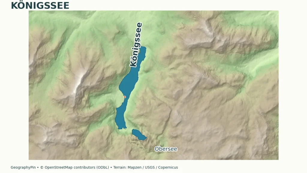
A long, narrow lake beneath steep Alpine slopes can look like a coastal fjord even when it lies far inland. At Königssee, the shape of the valley, the wooded shores and the separate basin of Obersee help explain a landscape that a single photograph can easily compress.
Königssee is a freshwater lake near Berchtesgaden in southeastern Bavaria, Germany. Its steep-sided glacial valley gives it a fjord-like appearance, but it is not a sea inlet. The separate Obersee lies beyond its southern end, while St. Bartholomä marks a peninsula on Königssee’s western shore.
How to use this article: Start with the map landmarks, compare the lake measurements, or see why Obersee is separate.
1. Where Is Königssee in Bavaria?
Königssee is in Schönau am Königssee, near Berchtesgaden in southeastern Bavaria, Germany. It is an inland Alpine lake, not a waterway along the German coast. The Watzmann massif rises to its west; the Jenner and Gotzenberg stand to the east. At the head of the valley, the smaller Obersee continues the sequence of water and mountain walls.
Orient yourself from north to south
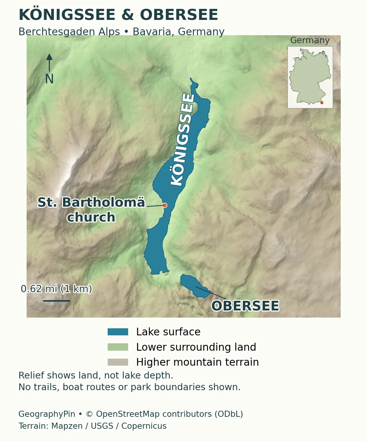
Begin with the northern end of Königssee, where the main visitor landing is located. Follow the long lake southward to St. Bartholomä, the church and peninsula on its western shore. Farther south, Salet is the landing associated with onward visits to Obersee. The smaller lake lies beyond the intervening land, not inside a southern bay of Königssee. The map labels the two lakes and St. Bartholomä; it does not mark boat routes or every landing.
A place name can describe more than one thing on a visitor map. St. Bartholomä identifies a landmark and destination, while Königssee names the lake itself. Salet is not another name for Obersee. Keeping those distinctions straight makes photographs, boat information and landscape descriptions easier to match to the correct location.
2. How Deep and Large Is the Lake?
The Bavarian water-management office’s lake profile supplies the measurements below. They describe a deep, narrow basin: the maximum depth is much greater than a view of the shoreline alone would suggest. The table does not represent a new survey or today’s water level.
| Measure | Value | How to read it |
|---|---|---|
| Maximum depth | About 623 feet (190 meters) | Deepest point, not the depth along every shore |
| Mean depth | About 322 feet (98.1 meters) | Average across the basin |
| Surface area | About 2.01 square miles (5.218 square kilometers) | The lake surface, not its catchment |
| Length | About 4.5 miles (7.2 kilometers) | Water-management profile reference |
| Reference surface elevation | About 1,979 feet (603.3 meters above sea level) | Profile elevation, not a live water-level reading |
Why some descriptions say roughly eight kilometers
The Bavarian Palace Administration gives the lake’s length as around 5 miles (8 kilometers), while the water-management profile lists about 4.5 miles (7.2 kilometers). Neither page explains that difference in measurement method. This article uses the water-management table consistently rather than combining the figures into an artificial average.
Depth, elevation and surrounding relief answer different questions. Depth is measured below the water surface; elevation places that surface relative to sea level. Relief describes the height differences in the surrounding land. A shaded mountain map can show the last of these without supplying a bathymetric survey of the lake floor.
3. How Ice Shaped the Valley
An older valley reshaped by ice
The national park’s account describes a valley following a fracture zone in the rock, first cut by flowing water and later enlarged by glaciers. Ice erosion widened and deepened the valley into a trough; water occupied the basin after the ice retreated. The modern lake is therefore part of a much longer landscape history, not evidence that today’s water body has existed unchanged for hundreds of millions of years.
The contrast between a river valley and a glacial trough concerns cross-section. A river commonly concentrates erosion into a relatively narrow channel. A valley glacier occupies a much broader space and can erode the floor and sides together. Once the ice disappears, the enlarged valley remains. Our guide to glacial erosion landforms explains how troughs, hanging valleys and other features fit that wider pattern.
Fjord-like does not mean a fjord
Königssee is often described as fjord-like because its long, narrow surface lies between steep mountain walls. That is a comparison of appearance. A fjord is a glacially carved coastal valley flooded by seawater; Königssee is a freshwater lake far above sea level. Similar shapes do not make the two water bodies geographically identical.
A useful way to read the landscape is to separate the shape of the basin from the water now filling it. Glacial erosion explains the trough. The present drainage system explains why it is a lake rather than a marine inlet. Neither the green appearance of the water nor a dramatic photograph can establish that distinction on its own.
4. Königssee and Obersee: Two Lakes, Not One
Obersee is a separate lake southeast of Königssee, linked to it by a stream. The land between the two is important evidence, not simply an obstacle on the way to a viewpoint. It preserves material deposited by ice as well as debris that fell from the surrounding slopes.
The separation is not explained by a medieval rockslide alone
The Bavarian Environment Agency’s geotope account describes glacial sediments beneath later rockfall debris. It specifically challenges the older assumption that a historical rockslide split one lake into two. The national park likewise identifies a moraine associated with a late glacial advance as the separating feature.
There is a narrower historical uncertainty. Park visitor material assigns large boulders beside the path to a rockfall in 1172, while the Environment Agency says a connection with a twelfth-century earthquake is not demonstrated. The secure geographic point is the sequence: glacial deposits came first, with rockfall material added above them later. A firm medieval date is not needed to explain why the lakes are separate.
This illustrates the difference between erosion and deposition. Ice can excavate a basin while also transporting sediment that is eventually left behind as a moraine. Later slope failures add another layer. A single scenic valley can therefore preserve several processes rather than one simple origin story.
5. Where the Water Goes
Königssee has an outlet: its water drains through the Königsseer Ache into the Berchtesgadener Ache, then onward through the Salzach, Inn and Danube system. It is not a closed basin where evaporation is the only way water can leave. Obersee’s connection to Königssee is one part of this larger downhill network.
The water-management office classifies Königssee as nutrient-poor. That describes nutrient availability in the lake, not a blanket drinking-water guarantee or an independently established cleanliness ranking. Clear-looking water and low nutrient levels should not be treated as interchangeable measures of every aspect of water quality.
The distinction also helps explain what makes a lake a lake: water occupies a basin even when inflows and an outlet connect it to rivers. A lake is not necessarily isolated, motionless or hydrologically self-contained. Following the outlet on a regional map reveals connections that a close-up photograph hides.
6. Reading the Landscape Before a Visit
The steep sides that make Königssee visually distinctive also limit simple lakeshore access. Bayerische Seenschifffahrt states that there is no continuous shore path connecting the northern landing with St. Bartholomä and Salet, and no lakeside path between St. Bartholomä and Salet. Mountain routes are a different proposition from a level promenade around the water.
The national park describes a walk from the Salet area to the western shore of Obersee. Do not confuse that local connection with walking the length of Königssee. Similarly, the Malerwinkel circuit near the northern shore is a local loop, not a complete circuit of the lake.
Most of Königssee lies within Berchtesgaden National Park. The park’s landscape includes both areas managed primarily for natural processes and areas where established uses continue. A boat landing or church does not mean the wider shore is an unrestricted recreation area.
For an actual visit, check the boat operator’s current service information and the national park’s route guidance. Salet service is seasonal, and a geographic map does not establish whether a boat or path is available on a particular day. This profile intentionally keeps changing fares and departure times separate from the enduring geography.
What Did We Learn Today?
Königssee combines a deep freshwater basin with the steep walls of a glacial trough. Obersee is a separate lake, and the deposits between them record ice activity followed by later rockfall. Following the shoreline landmarks, distinguishing depth from elevation, and tracing the river outlet reveal more than the familiar fjord-like view alone.
Sources & Data Notes
US customary measurements are rounded conversions. The water-management profile supplies the numerical lake dimensions; other official descriptions use different rounded lengths without explaining their methods. The geological explanation distinguishes older glacial deposits from later rockfall and does not assume a verified medieval earthquake connection.
- Wasserwirtschaftsamt Traunstein: Königssee. Lake dimensions, drainage and nutrient classification. Profile measurements are not a live gauge report.
- Bavarian Palace Administration: Königssee and Obersee. Mountain setting, lake connection and contrasting rounded length description.
- Berchtesgaden National Park: park leaflet, March 2024. Valley development and moraine explanation; visitor account of the historical boulders.
- Bavarian Environment Agency: geotope 172R029. Glacial sediment beneath later rockfall deposits; limits of the medieval-earthquake interpretation. Geological description dated December 2018.
- U.S. National Park Service: glacial valleys and fjords. General distinction between glacial troughs and seawater-filled fjords.
- Bayerische Seenschifffahrt: visitor questions. Shore-access limitations. Consult the operator separately for current service.
- Berchtesgaden National Park: easy walks. Local Malerwinkel and Obersee route context, not a guarantee of current trail conditions.
Map sources and method: Original GeographyPin cartography uses lake outlines and the church location from © OpenStreetMap contributors, under the Open Database License. The two lake outlines are separate polygons; the small island within Königssee is retained. Terrain is drawn from the historical Mapzen elevation-tile collection, with USGS and Copernicus source attribution; produced using Copernicus data and information funded by the European Union – EU-DEM layers. Additional regional source credit: Austrian terrain © offene Daten Österreichs, Digitales Geländemodell (DGM) Österreich. Exact per-tile source composition was not independently resolved. Shading describes surrounding land elevations, not lake-bottom depth, current vegetation or hiking difficulty. The scale is approximate for the map’s central latitude. The separate Germany locator inset uses public-domain Natural Earth country geometry and is not at the scale of the main map. The map does not depict national-park boundaries, trails or present boat services. OpenStreetMap geometry is used for illustration, not to replace the water-management office’s published measurements.