Kaspi, Georgia is a historic small town in the Shida Kartli region of central Georgia (the country). Situated on the Mtkvari River about 50 kilometers (30 miles) northwest of Tbilisi, records first mention Kaspi in the 4th century AD, and authorities granted it town status in 1959. Today it has roughly 12,700 residents and is known both for its medieval heritage and for housing one of Georgia’s largest cement factories.
Location and Geography

Position and Setting
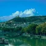
Kaspi lies in central Georgia, in the eastern part of Shida Kartli. The town sits on the banks of the Mtkvari (Kura) River, which skirts Kaspi’s outskirts and long served as a route for water and transport.
Kaspi stands about 50 km (31 mi) northwest of Tbilisi, roughly midway along the highway and rail line between Tbilisi and Gori. Elevation ranges from about 560 m (1,840 ft) by the river to around 700 m (2,300 ft) in nearby foothills, placing the town on the Shida Kartli plain.
Climate and Landforms
The climate is moderate and typical of eastern Georgia’s inland valleys: hot, dry summers and cold winters. Forested slopes of the Trialeti Range rise to the south, while Caucasus foothills edge the north. These features temper the weather and frame the scenery.
Agriculture and Land Use
Fertile soils support vineyards and orchards across the countryside. The district devotes roughly one-third of its land to forests, so fields, woodlands, and the winding river valley alternate across the landscape. Viticulture and fruit farming remain visible markers of local life.
Historical Background
Deep Roots and Early Records
Archaeological finds trace human presence here to the Stone Age. The settlement took shape in the early Middle Ages. Kaspi ranks among Georgia’s oldest towns: written sources mention it in the 4th century AD as a key place in the ancient Georgian kingdom of Iberia.
Its strategic location along major trade routes drew caravans. The late antique Peutinger Map includes Kaspi among Roman roads. By the 5th century, under King Vakhtang Gorgasali of Kartli, Kaspi had grown into a fortified, prosperous town. Chronicles note its reputation as an educational center; nobles, including Vakhtang’s sister Mirandukht, reportedly studied and lived here. The town had its own spasalar (military governor), signaling military and administrative importance.
Early History
In the 8th century, war struck Kaspi. Around 735–737, Arab commander Marwan II (Marwan the Deaf) attacked and destroyed the town. Life halted, and ruins remained for a time.
Later centuries brought recovery under various Georgian realms. By the 15th century, the influential Amilakhvari family controlled Kaspi as a small fortress-town. In the late 16th century, King Simon I of Kartli seized Kaspi from the Amilakhvaris and donated the town and its lands to the Georgian Orthodox Church, specifically to Svetitskhoveli Cathedral in Mtskheta. Under the Russian Empire in the 19th century, Kaspi declined to a quiet village.
The 20th century reshaped Kaspi. After the Soviet takeover, it regained administrative weight. In 1930 the Soviets created Kaspi District (raion), and the settlement began to urbanize as industry spread after World War II.
Modern Era
Authorities conferred town status in 1959. Industrial development accelerated. During the 1950s–1980s, manufacturers produced textiles and furniture, but the standout project was the large cement plant. Opened in 1931, it grew into one of Georgia’s largest industrial sites and, by the late 20th century, produced over 760,000 tonnes of cement annually.
Kaspi endured the 2008 Russia–Georgia war. Air raids bombed the cement factory and the railway bridge, damaging key infrastructure. In the aftermath, the town repaired and upgraded facilities. A new plant opened in 2019 to replace older kilns, cutting dust and noise. Today, Kaspi blends old and new—ancient roots and a cautious, forward-looking economy.
| Year / Period | Key Event in Kaspi |
|---|---|
| 4th century AD | Records first mention Kaspi as a major town in the ancient Georgian kingdom of Iberia. |
| c. fifth century | Kaspi flourishes under King Vakhtang Gorgasali as an educational and military center in Kartli. |
| 8th century | Arab forces under Marwan II destroy the town; life in Kaspi halts for a time. |
| 15th–16th centuries | The Amilakhvari noble family controls Kaspi; later, King Simon I seizes it and donates the town to the Georgian church. |
| 1930 | The Soviet government creates Kaspi District (raion), making Kaspi the administrative center. |
| 1959 | Authorities grant Kaspi official urban town status. |
| 2008 | During the Russia–Georgia war, air raids bomb the cement plant and the railway bridge, underscoring Kaspi’s strategic importance. |
Population and Demographics
Population Trend
Kaspi is a relatively small town. In 2023 it had an estimated 12,700 inhabitants, and a preliminary 2024 count put the figure at about 12,415. The number has declined from earlier decades: more than 15,000 residents in 2002 fell to roughly 13,423 by 2014.
This mirrors broader Georgian trends as young people move to larger cities. Even so, Kaspi remains the district’s main urban center and draws villagers for schools, markets, and services.
Ethnic and Religious Makeup
Kaspi is predominantly Georgian. According to 2014 data, about 91% of residents are ethnic Georgians. A notable Azerbaijani minority makes up roughly 6%, with roots in nearby villages. Smaller Armenian and other communities also live here.
Georgian is the dominant language. Most residents follow the Georgian Orthodox Church. A minority—primarily among Azerbaijani Georgians—are Muslim. This mix adds cultural variety to daily life.
Age Profile and Community Life
The demographic profile skews slightly older, as many young adults leave for higher education and jobs in Tbilisi. Local schools, a public library, and a cultural center support families and help keep community ties strong. Life moves at a friendly, slower pace, and neighbors often know one another well.
Economy and Industry
Cement Industry
Industrial production defines Kaspi’s economy. The flagship is the Kaspi cement plant, among the South Caucasus’s largest. Established in 1931, it became a major employer and driver of growth. By the 2010s, annual output reached about 0.76 million tonnes, supplying construction across Georgia.
Operated in recent years by HeidelbergCement Caucasus, the plant has also raised environmental concerns. A 2010 ministry study named it a top air polluter due to dust and coal-fired kilns. Residents reported dust impacts, which spurred filtration upgrades and a major modernization. In 2019, a new production line replaced the old rotary kilns, significantly reducing dust and noise. The factory still provides hundreds of jobs and substantial revenue.
Other Industries
Kaspi municipality also hosts construction-materials firms that use local limestone and clay, including brick-making. Small manufacturers operate an alcohol distillery, a canning factory, and a confectionery plant. Many date to Soviet times; some faced post-Soviet headwinds, yet they continue to support local employment.
Agriculture
Rural areas around Kaspi rely on fertile land. Farmers grow grapes, peaches, apples, and vegetables, supplying the town’s market. Viticulture stands out: the district’s grapes feed Georgia’s renowned wine industry. Households also keep cattle and poultry. Small-scale farms preserve traditional rural life and provide self-sufficiency.
Services
The service sector remains modest but has grown. As a district capital, Kaspi hosts government offices, schools, a hospital, and shops. A few small hotels and guesthouses now welcome visitors who come for historical sites. Industry and agriculture together anchor the town’s livelihood.
Culture and Attractions
Major Landmarks
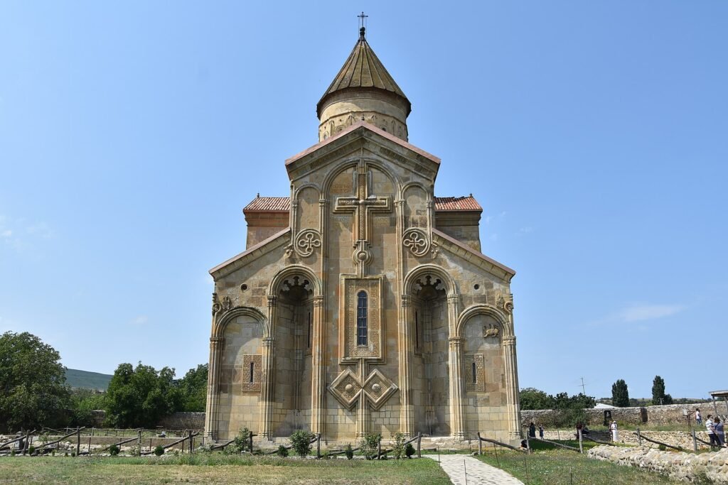
Kaspi sits amid a dense cluster of cultural monuments. The Samtavisi Cathedral, built around 1030, exemplifies Georgian medieval design with its elegant dome and intricate stonework. The nearby Kvatakhevi Monastery (12th–13th centuries) rests in the hills and offers quiet cloisters and carved façades. Along the Tedzami River, the Rkoni Monastery and Fortress pairs a 7th-century church with fortress ruins reachable by scenic paths.
Museums and Archaeology
In town, the Kaspi Local Museum of History and Ethnography preserves more than 20,000 regional artifacts. The collection spans Bronze Age tools, pottery, medieval weapons, jewelry, and manuscripts. Exhibits connect to Grakliani Hill on the nearby highway, where excavations revealed material from the 2nd millennium BC and an early script inscription possibly from the 7th century BC.
Townscape Highlights
Kaspi’s St. George’s Church—sometimes called the Kaspi Cathedral—dates to the 19th century and was recently renovated. Its white-stone walls and bell tower shape the skyline. In the central square, a World War II memorial honors residents who fell in the conflict, reflecting the period’s heavy toll.
Nature and Outdoor Spots
The Mtkvari River and green hills invite fishing, picnics, and short hikes. The Rkoni canyon draws visitors to a medieval stone arch often called “Queen Tamar’s Bridge.” Waterfalls at Tskhaveri and Noste add peaceful viewpoints. Spring and summer bring wildflowers to the fields around town.
Traditions and Everyday Culture
Kaspi keeps Georgian traditions alive. Orthodox festivals such as Alaverdoba and the feast of St. George fill churches and community supras (banquets). Folk singing and dance groups perform at the House of Culture. Visitors won’t find big-city nightlife, but they often encounter generous hospitality—homemade wine, cheese, and khachapuri shared at long tables.
Transportation and Accessibility
By Road
Kaspi sits just off Georgia’s east–west E60 highway linking Tbilisi and Gori. Driving from Tbilisi takes about 50–60 minutes for the ~50 km distance. Marshrutka minibuses run several times daily from Tbilisi’s Didube station and typically need 1 to 1.5 hours, depending on stops.
By Rail
Georgian Railway operates commuter trains between Tbilisi and Kaspi. Departures occur a couple of times daily, and the trip usually lasts 47–55 minutes. The station stands on the town’s northern edge, on the mainline continuing to Gori, Kutaisi, and the Black Sea.
Getting Around Town
Kaspi is compact and walkable. Taxis serve local trips, and residents use cars or minibuses to reach nearby villages. Central streets are paved and in fair condition, while some rural roads remain gravel.
Air Access
Tbilisi International Airport lies about 60 km (37 mi) east of Kaspi—a drive of roughly 1 to 1.5 hours. This proximity makes Kaspi an easy day trip or stopover during tours of central Georgia.
FAQ
Where exactly is Kaspi, Georgia located?
Kaspi is located in central Georgia, in the eastern part of the Shida Kartli region. It lies on the Mtkvari (Kura) River, about 50 km west/northwest of Tbilisi. The town is roughly halfway between the cities of Mtskheta and Gori, just a short distance off the country’s main east–west highway.
How old is Kaspi and what is its historical significance?
Kaspi is one of Georgia’s oldest towns – it was first mentioned in the 4th century AD. In the early Middle Ages it was an important fortified town and educational center under King Vakhtang Gorgasali. Over the centuries, Kaspi saw periods of destruction (e.g. by Arab invasions in the 8th century) and revival. It became part of noble estates in the 15th–16th centuries and later developed as a Soviet industrial town in the 20th century. Its long history is evidenced by nearby ancient ruins and churches.
What is the population of Kaspi today and who lives there?
As of recent data (2023), Kaspi has around 12–13 thousand residents. The vast majority of locals are ethnic Georgians (over 90%) and Georgian is the main language. There is also a small Azerbaijani minority (a few hundred people) and a few Armenian and other families. The community is mostly Georgian Orthodox Christian, with a minority Muslim presence (mostly among Azerbaijani Georgians). Kaspi’s population has been slowly declining in recent years as some younger people move to bigger cities.
What is Kaspi best known for?
Kaspi is primarily known for its large cement factory, which is one of the biggest in Georgia. This industrial plant has put Kaspi on the map economically (and was even targeted in the 2008 war). Culturally, Kaspi is also known for its historical significance – it’s near important medieval landmarks like Samtavisi Cathedral and has archaeological sites (like Grakliani Hill) indicating very ancient habitation. In short, Kaspi is known both as an industrial hub and as a place with deep historical roots.
How can I travel to Kaspi from Tbilisi?
Kaspi is easy to reach from Tbilisi. You can drive – it’s about a 50–60 minute drive via the Tbilisi–Gori highway (approximately 50–65 km depending on your starting point). Alternatively, train service is available: Georgian Railway runs commuter trains from Tbilisi to Kaspi twice daily, taking roughly 50 minutes. Marshrutka minibuses also go to Kaspi from Tbilisi’s Didube station frequently and take about 1 hour. All options are affordable (just a few dollars) given the short distance.
Are there interesting places to see in and around Kaspi?
Yes. History enthusiasts can visit the Samtavisi Cathedral (an 11th-century church famed for its architecture) and the Kvatakhevi Monastery nearby. The town’s local museum in Kaspi showcases artifacts spanning Bronze Age to medieval times. Nature lovers can explore scenic spots like the Rkoni Fortress and Rkoni Monastery in a beautiful river gorge, or take a short hike to waterfalls in the Kaspi district. In town, you can see the St. George’s Church, the WWII memorial, and soak in the atmosphere of a typical Georgian small town. Kaspi is not a tourist hotspot, but it offers an authentic glimpse of Georgian history and rural life.
What Did We Learn Today?
- Ancient origins: Kaspi is among Georgia’s oldest towns – it was first recorded in the 4th century AD and was a major city in the ancient Georgian kingdom of Iberia.
- Modern population: Today the town is home to only about 12,000 people (as of 2023), making it small in size despite its historical significance.
- Industrial prominence: Kaspi hosts one of Georgia’s largest cement factories, producing around 760,000 tons of cement yearly and contributing significantly to the country’s construction industry.
- Wartime impact: During the 2008 Russia–Georgia war, the town’s cement plant and railway bridge were bombed and damaged, underscoring Kaspi’s strategic importance.
- Cultural heritage: The Kaspi area is rich in history, featuring landmarks like the 11th-century Samtavisi Cathedral and an archaeological museum with 20,000+ artifacts, revealing continuous human activity since prehistoric times.