Crater Lake’s blue water and steep enclosing walls can make it look like a simple hole in a mountain. Its real story is more revealing: a volcanic collapse, new eruptions inside the basin and a lake built by rain and snow. Even its famous depth needs to be separated from the height of the surrounding rim.
Crater Lake lies in southern Oregon within the caldera of Mount Mazama, which collapsed during a major eruption about 7,700 years ago. It is not an impact crater. The summer 2000 survey measured a maximum depth of 1,949 feet (594 meters), making it the deepest lake in the United States.
How to use this article: Distinguish lake and caldera, understand the collapse, explore the water balance, and check the dated access update before planning a visit.
1. Where Is Crater Lake?
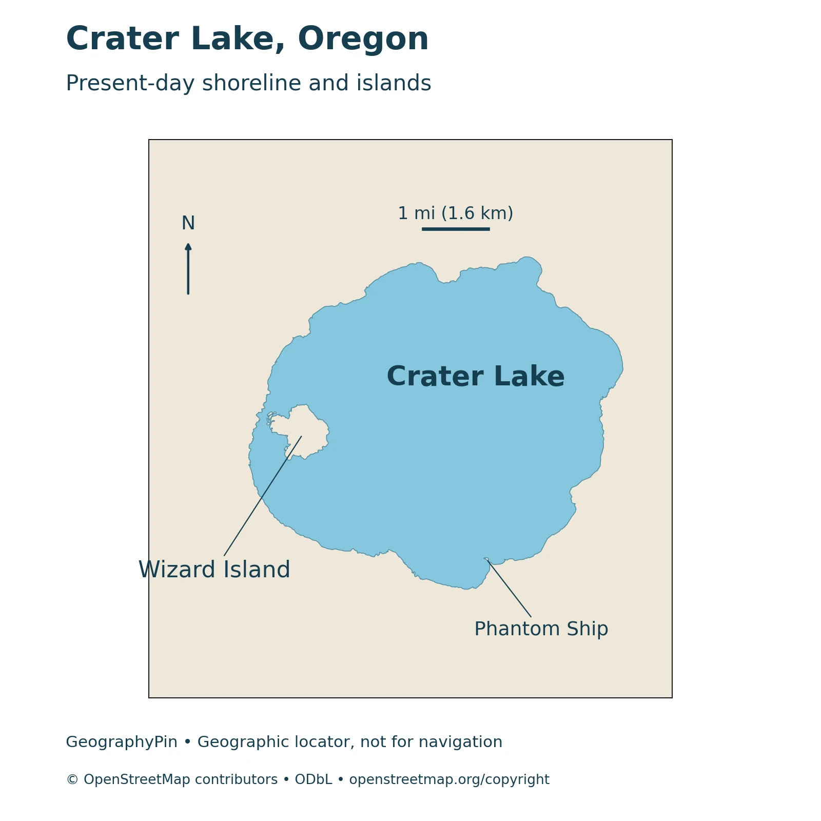
Crater Lake is in southern Oregon, near the crest of the Cascade Range. It lies within Crater Lake National Park in Klamath County. The surrounding mountain landscape is volcanic, but the lake is water occupying a basin within a volcano, not a separate mountain summit.
The lake, the caldera and the park
Three boundaries are easy to confuse. The lake shoreline encloses the water. The caldera rim stands above that shoreline and marks the large collapse depression. The national park extends beyond both and contains other mountains, forests and valleys. A figure describing the caldera’s width is therefore not automatically a measurement of the lake itself.
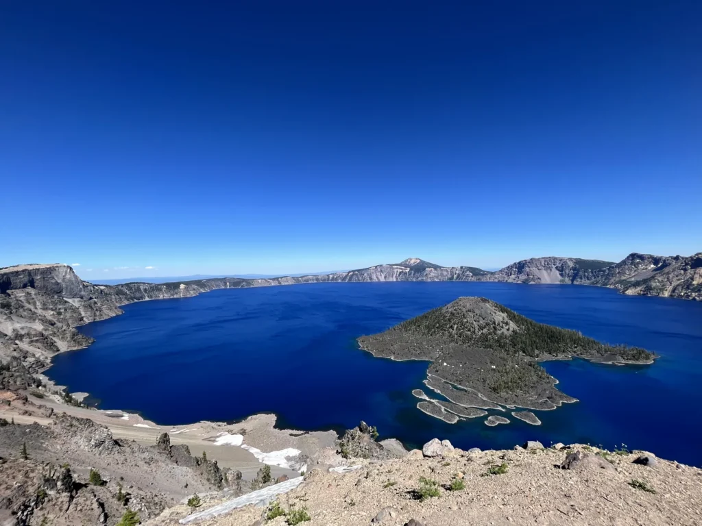
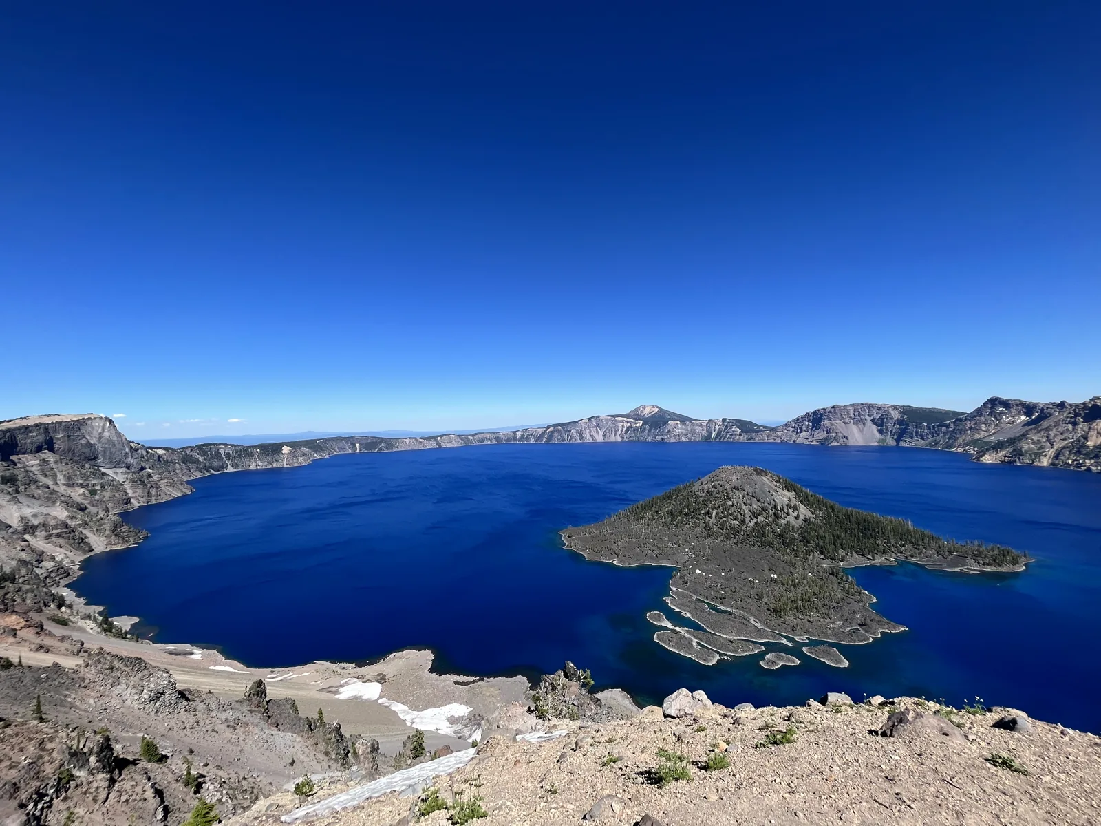
Wizard Island rises from the western part of the lake. Its volcanic cone is one of the most recognizable features in views from the rim. The locator in this article is for understanding these relationships, not for finding a legal route down the steep caldera walls.
2. Depth and Other Reference Facts
Crater Lake is the deepest lake in the United States. Its commonly cited maximum depth of 1,949 feet (594 meters) comes from the modern survey completed in the summer of 2000, not from a new measurement made when a web page was last updated.
Maximum depth is not average depth
| Feature | Reference | Interpretation |
|---|---|---|
| Maximum water depth | 1,949 feet (594 meters) | USGS account of the summer 2000 lake-floor survey |
| Lake surface area | About 20.5 square miles (53 km²) | Reference area reported in a 2007 limnological study |
| Caldera width | About 5 by 6 miles (8 by 10 km) | Collapse basin dimensions, not the lake’s water area |
| Caldera-forming eruption | About 7,700 years ago | Mount Mazama’s major eruption and collapse |
Depth measures the distance between the water surface and the bottom. Elevation measures height relative to a reference level such as sea level. A mountain’s summit elevation, the rim’s elevation and the lake surface’s elevation are different quantities and should not be substituted for one another.
The deepest point is also not representative of every part of the lake floor. Sonar and submersible investigations have revealed volcanic cones, platforms and deposits beneath the water. A simple outline map does not show that underwater relief, and the conceptual formation panels below are not a measured lake-floor cross-section.
The area conversion in the table is rounded. Survey results and reference dimensions describe the basin; they do not provide a live lake-level report or a current navigation chart.
3. How Mount Mazama Became a Caldera
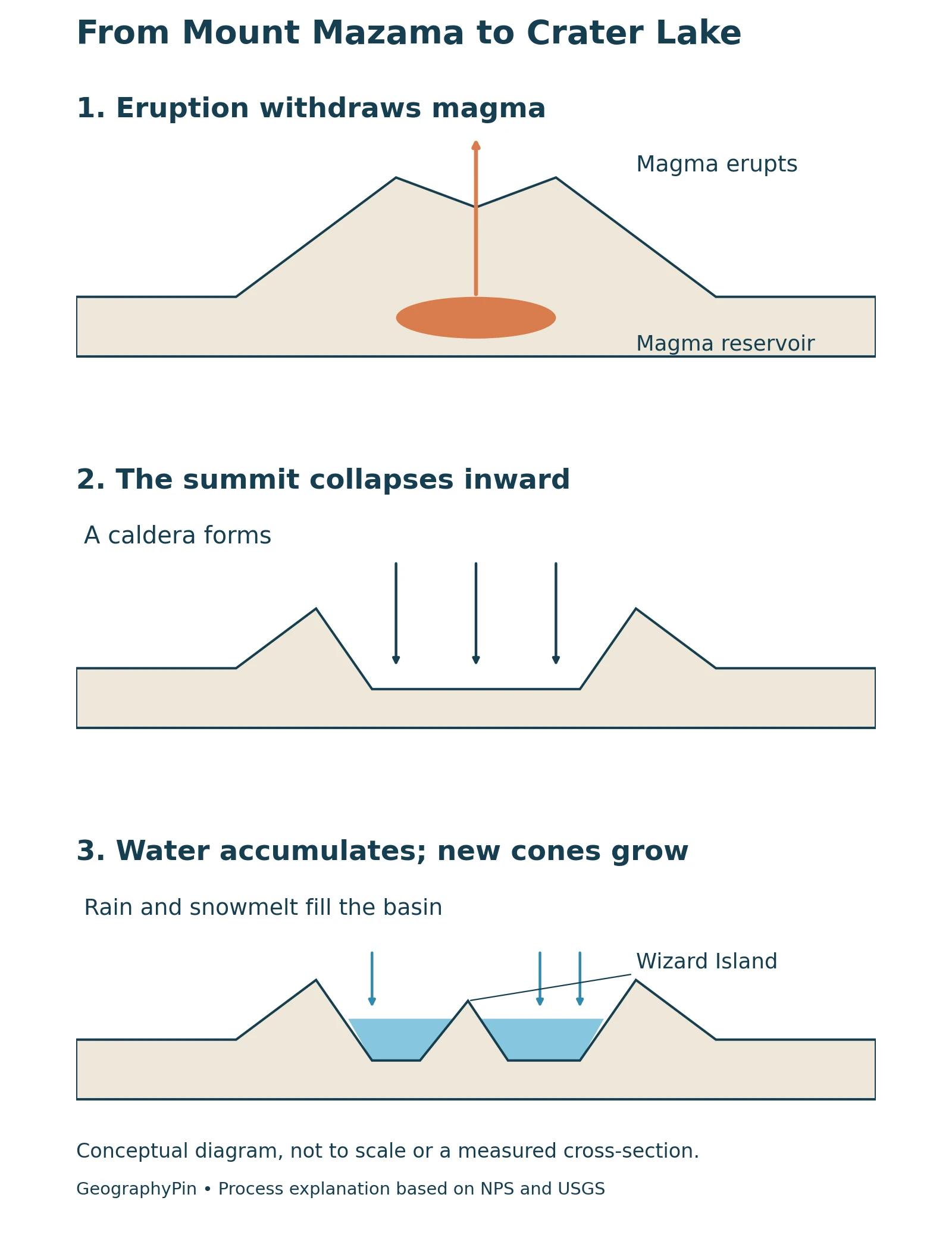
Despite the name, Crater Lake does not fill a meteorite-impact crater. It occupies a volcanic caldera, a large depression created when the upper part of Mount Mazama collapsed during a major eruptive episode.
Eruption, withdrawal of magma and collapse
Mount Mazama developed over a long history of volcanic activity. About 7,700 years ago, a powerful eruption discharged large amounts of volcanic material. As the eruption depleted the underlying magma reservoir, the overlying mountain lost support and collapsed inward. The result was a broad basin within the remaining flanks of the volcano.
It is misleading to imagine the entire mountain simply being blasted away and leaving a neat hole of the same size. Ejection of material and structural collapse were connected processes. The surviving rim and outer slopes are parts of the larger volcanic landscape.
Over time, rain and melting snow accumulated in the depression. The lake now partially fills the caldera; its water surface does not reach the rim. This distinction explains why the drop from an overlook to the water and the water’s own depth are separate measurements. Volcanic basins are one of the formation types discussed in our guide to how lakes form.
4. Wizard Island and the Hidden Lake Floor
Volcanic activity continued after the main collapse. Wizard Island is not the exposed peak of the original Mount Mazama. It formed from later eruptions within the newly created caldera.
An island growing as the water rose
USGS describes new vents building the base of Wizard Island and other volcanic features while rain and snowmelt were beginning to fill the basin. The growing cones and rising water were part of an overlapping history, rather than a sequence in which the lake first filled completely and an island appeared only afterward.
Other volcanic structures remained below the surface or were eventually submerged. Sonar mapping reveals features that a visitor looking across the blue water cannot see. The island above water is therefore only part of the post-collapse volcanic landscape.
The presence of an old volcanic cone does not establish current access to it. Wizard Island visits depend on permitted shore and boat access, which can be suspended for construction, weather or other park-management reasons.
5. Water Supply, Clarity and Blue Color
Crater Lake has no large river flowing through it. Rain and snow supply water to the lake and its small surrounding catchment. Small streams and springs can contribute surface inflow, but there is no outlet stream carrying water over the rim.
Why the lake does not fill to the top
Water leaves through evaporation and seepage into the surrounding rock. The balance between incoming precipitation and these losses helps determine the lake level. No visible outlet river does not mean that all incoming water remains in the basin indefinitely.
Its deep blue appearance also has a physical explanation. Light interacts with the water: longer wavelengths are absorbed more readily, while some shorter blue light is scattered back toward an observer. Great depth and relatively clear water make this effect particularly striking. The color is not simply a blue sky painted onto the surface.
Clarity and depth should not be confused. Researchers measure water transparency using instruments such as a Secchi disk, lowered until it disappears from view. The disappearance depth is not the distance to the lake bottom. A 2007 study reported seasonal and annual variation in Crater Lake’s clarity, so one reading should not be presented as a permanent lake-wide value.
Nor does an attractive color demonstrate drinking-water safety. This profile describes the lake’s geography and optical properties, not a water-quality test for personal use.
6. Snow, Roads and Shore Access
Snow affects travel around Crater Lake even though the deep lake itself rarely freezes over completely. The rim roads, viewpoints and trail to the water are separate access questions. Seeing the lake from above does not mean the shoreline or Wizard Island can be visited.
Shore access during the Cleetwood Cove closure
Checked November 13, 2026: The National Park Service lists Cleetwood Cove Trail as closed for the 2026, 2027 and 2028 seasons for major rehabilitation. It is the only legal route to the lake shore. Do not use an older guide’s normal summer swimming, fishing or boat-tour description as evidence that shore access is currently available. The project notice is not a guarantee of a particular reopening date.
On the same check, the park listed Rim Drive and the North Entrance Road as closed for the season. Highway 62 through the park and the road to Rim Village were listed open, with lake views weather-dependent. These are dated observations, not promises for your travel day.
Before setting out, consult the park’s current conditions and Cleetwood Cove project notice. Snow, visibility and road restrictions can change. Stay on permitted routes rather than attempting to reach the water by descending another part of the caldera wall.
What Did We Learn Today?
Crater Lake fills part of a volcanic collapse caldera, not a meteorite crater. Its deep water, later volcanic island and precipitation-fed water balance explain different parts of the landscape. Surveyed depth is separate from clarity and rim elevation, while current road and shoreline access must be checked independently of the lake’s enduring geography.
Sources & Data Notes
Maximum depth is attributed to the summer 2000 survey described by USGS, not to the publication date of its web summary. Lake area comes from the 2007 study and is rounded when converted to square miles. Caldera dimensions describe a different feature. The map retains the source lake shoreline and island holes from OpenStreetMap; it is not a map of the caldera rim or a permitted trail. Formation panels are conceptual and carry no measured magma-chamber, ancient mountain-profile or historical waterline dimensions. Access statements were checked November 13, 2026 and should be rechecked directly with the park before travel.
- USGS: Crater Lake location, caldera and deepest-U.S.-lake designation
- USGS: Mount Mazama and the caldera-forming eruption
- USGS: summer 2000 survey and lake-floor research
- USGS: Wizard Island and overlapping lake filling and volcanic growth
- Larson and colleagues, 2007: lake area, inflows and changing clarity
- National Park Service: water balance and blue color
- National Park Service: snow, lake filling and rare complete freezing
- National Park Service: conditions checked November 13, 2026
- National Park Service: only legal shore route and 2026–2028 closure