Costa Rica is a Central American country between Nicaragua and Panama, bordered by the Pacific Ocean and Caribbean Sea. Its geography combines volcanic ranges, the high Talamanca mountains, inland valleys and coastal lowlands. San José lies in the Central Valley. Mountain relief and contrasting rainfall regimes help explain why the two coasts and the interior differ.
How to use this article: Compare the highest mountains with the volcano-only picture, distinguish the Central Valley from the metropolitan area, or jump to the two coasts’ rainfall patterns.
1. Where Is Costa Rica?
Costa Rica is a Central American country between Nicaragua and Panama, with the Pacific Ocean to its west and south and the Caribbean Sea to its east. It belongs to the North American continent under the usual continental convention. Its position within the narrow Central American land bridge is more informative than simply calling it a tropical country.
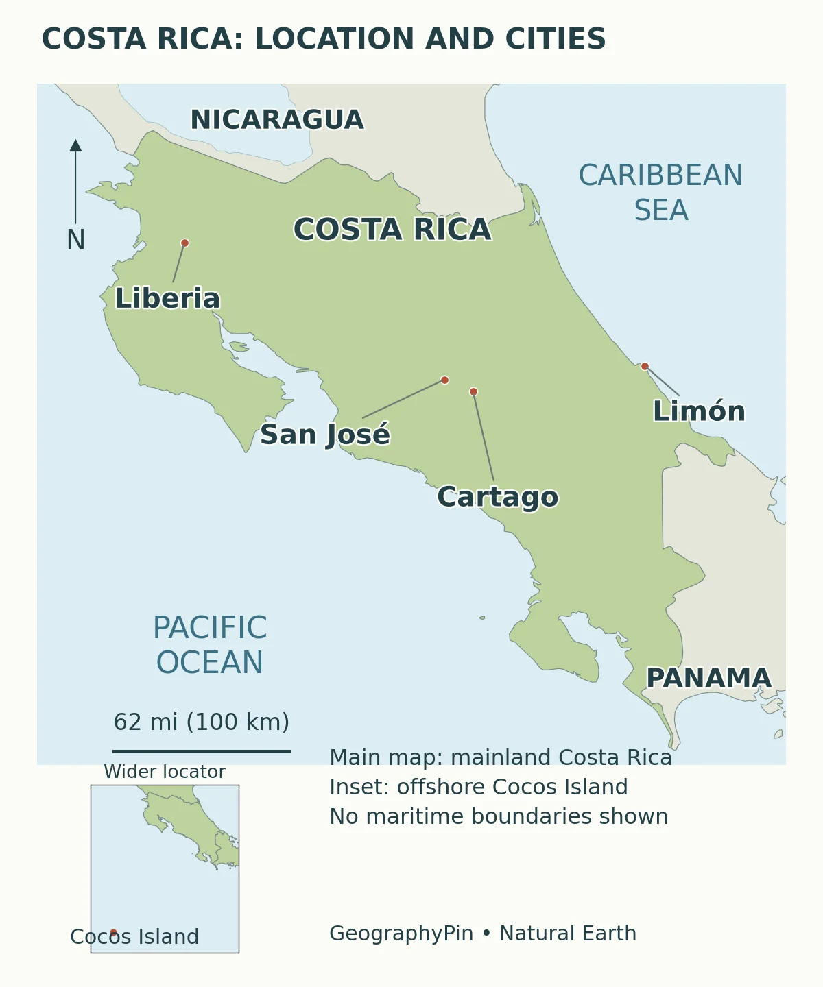
San José, Costa Rica’s capital, is inland rather than on either coast. Liberia provides a reference point in the northwest, Limón on the Caribbean side, and Cartago east of the capital. These locations help connect country-level facts to actual places. They are orientation points, not a ranking of the largest or most important settlements.
Costa Rica also includes offshore islands. Cocos Island, far out in the eastern Pacific, should not disappear from the idea of the country simply because a mainland map cannot show it at a useful scale. Land territory and maritime jurisdiction are different measurements. For the wider regional setting, see our Central America countries map.
2. Country Facts and Dated Figures
A country table needs more than a number: it needs the kind of number and its reference date. The population below comes from the national statistics office’s Costa Rica en cifras 2025, rather than from a real-time population counter.
| Fact | Figure or answer | Scope |
|---|---|---|
| Capital | San José | National capital, not the entire metropolitan region |
| Land area | About 19,730 square miles (51,100 square kilometers) | INEC, Costa Rica en cifras 2025; terrestrial area |
| Population | 5,191,823 | June 30, 2025; INEC population projection, not a live count |
| Highest point | Cerro Chirripó, about 12,530 feet (3,820 meters) | SINAC park reference; rounded elevation |
| Language | Spanish | Language listed in INEC’s national facts; not a claim that no other languages are spoken |
| Land neighbors | Nicaragua and Panama | National land boundaries |
| Coastal waters | Pacific Ocean and Caribbean Sea | The Caribbean is part of the Atlantic Ocean system |
A population projection is not a census count
The 2025 figure describes June 30 of that year and is published as part of INEC’s estimates and projections program. It should not be relabeled a 2026 census result. A projection combines a population base with assumptions and demographic evidence; a census is an enumeration exercise. Differences between releases can reflect revisions as well as population change.
The land-area figure likewise should not be compared directly with a much larger maritime area. Coastline length is omitted because it changes with mapping resolution and the features included. Neither an apparently precise coastline total nor an undated population figure would make the physical geography clearer.
3. Mountains: More Than a Line of Volcanoes
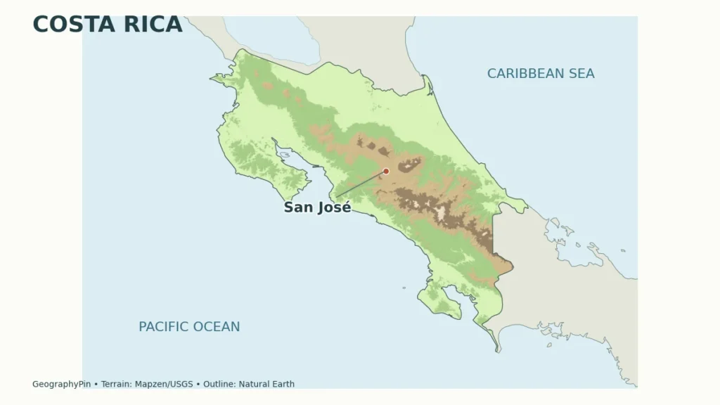
Mountains run broadly northwest to southeast through Costa Rica, but the spine is not one uniform string of currently active volcanoes. The Guanacaste and Central volcanic ranges contrast with older, deeply dissected mountain terrain in Tilarán-Aguacate and the high Talamanca range farther southeast.
A recent geomorphological study distinguishes active volcanic ranges from older magmatic and plutonic mountain systems and from intervening tectonic depressions. That distinction matters when reading relief: a high summit does not automatically identify an active volcano, and an intermontane basin is not simply an empty gap in a chain of cones.
Chirripó and the limits of a volcano-only picture
Cerro Chirripó, in the Talamanca range, is the country’s highest point. SINAC gives its elevation as about 12,530 feet (3,820 meters). UNESCO describes the wider Talamanca–La Amistad landscape as a high mountain conservation area with evidence of past glaciation. Glacially shaped valleys and mountain grasslands add another chapter to the country’s landscape history.
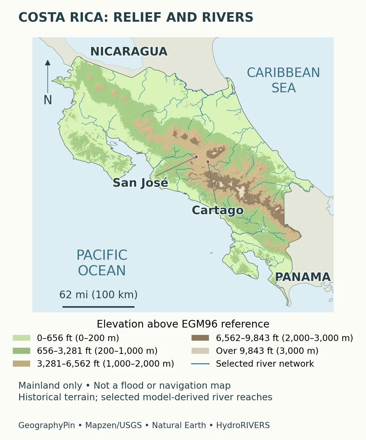
Read the relief map in two steps: first find the high ground, then look at the valleys and lower passages between it. Those relationships help explain why a straight line between two towns is not a description of the route connecting them. The map depicts terrain, not current volcanic activity or road conditions.
4. Rivers Connect the Interior to Two Coasts
Rain falling on different parts of the interior can reach different coastal waters. The Río Grande de Tárcoles system drains toward the Pacific, while the Reventazón–Parismina system carries water toward the Caribbean. These are useful examples of connections between uplands, settled valleys and coastal lowlands, not an exhaustive inventory of Costa Rican rivers.
Follow a river system, not just its most familiar name
The lower-course name is important on the Caribbean side. A published account of the Reventazón explains that it joins the Parismina in the lowlands and the combined flow reaches the Caribbean under the name Parismina. A country map that labels a major river needs to respect that connection rather than extend one familiar name across every downstream reach.
River basins and administrative areas answer different questions. A basin follows the movement of water; a province or municipality follows an administrative boundary. Research comparing management of the Tárcoles and Reventazón basins emphasizes why cooperation across jurisdictions matters for water management.
Hydroelectric development on the Reventazón also shows that rivers are not just blue lines dividing a landscape. Water, gradients, reservoirs, communities and ecosystems are connected. An elevation map can show the setting, but it cannot establish a safe crossing, a current flow or whether a particular reach is suitable for recreation.
5. The Central Valley and Its Cities
The Central Valley is the inland setting of Costa Rica’s principal urban concentration. San José, Alajuela, Heredia and Cartago are distinct cities within this wider settlement system. The National Museum’s geographic description emphasizes valleys, hills, river canyons and the surrounding mountains, rather than treating the region as a flat platform.
Central Valley and Greater Metropolitan Area are not synonyms
The Central Valley is a geographic landscape. The Greater Metropolitan Area, usually abbreviated GAM from the Spanish Gran Área Metropolitana, is a metropolitan and planning concept. San José is also the name of a city and a province. Those units overlap, but they are not interchangeable containers for population or land area.
This is why a percentage describing the metropolitan population needs its boundary and date. Even an authoritative study can use a specially defined study area rather than the boundary another publication uses. The museum explicitly identifies the area delimited for its own work; its extent should not be silently turned into a universal definition of the GAM.
For reading the country map, the practical point is simpler: the capital and neighboring urban centers sit within a mountainous interior, while other communities occupy coastal and lowland settings. Compare the city locations with the relief before assuming that all major economic activity lies along the coast.
6. Why the Two Coasts Have Different Rainfall Patterns
Costa Rica’s tropical location does not produce one uniform rainfall calendar. The Instituto Meteorológico Nacional distinguishes Pacific and Caribbean rainfall regimes, then subdivides the country into seven broad climatic regions. Elevation, mountain orientation, prevailing winds and ocean influences help explain the differences.
The Pacific dry season is not a nationwide rule
IMN’s general climate guide describes a clearer dry season on the Pacific side, broadly December through March, with transition months and regional variation. Its wetter period broadly occupies May through October. The Caribbean side does not have an equally defined dry season: relatively less-rainy periods do not mean rain disappears.
The contrast can be especially revealing around September and October. In the guide, these are among the wettest months on the Pacific side but form a relatively drier period along the Caribbean coast. “The rainy season in Costa Rica” therefore needs a location before it becomes a useful statement.
These are broad climatological patterns from a historical climate guide, not a forecast for a particular week. Nor does a lowland rainfall pattern describe a high mountain site. If you move between Liberia, the Central Valley and Limón, compare regional climate and elevation rather than carrying one coastal expectation across the country.
7. Elevation, Forests and Protected Landscapes
Costa Rica’s habitats are better understood as connected gradients than as one continuous rainforest. In the northwest, the Área de Conservación Guanacaste protects important tropical dry-forest habitats as well as mountain and marine-coastal environments. Dry forest is not failed rainforest; seasonal dryness is part of the conditions to which its organisms are adapted.
At a different scale, the transboundary Talamanca–La Amistad protected landscape spans major changes in elevation and habitat across Costa Rica and Panama. UNESCO describes lowland and mountain forests, cloud forest and high-elevation grassland within that wider landscape. A national boundary does not stop the mountain system or its ecological connections.
These two examples explain more than an unsupported claim that the whole country is equally biodiverse. Guanacaste illustrates seasonal and coast-to-mountain contrasts. Talamanca illustrates elevation and cross-border continuity. The places differ in physical setting, so the conservation questions differ too.
A general relief map helps locate those contrasts but is not a vegetation survey. It cannot tell you which species occur at a particular point or whether a trail is open. Protected-area boundaries, visitor rules and current access require the relevant park information, not inference from a green patch on a country map.
8. Livelihoods and Connections Beyond the Tourist Map
Costa Rica’s economy should not be reduced to beaches and wildlife tourism. Agricultural production, services and manufacturing connect different parts of the country to domestic and international markets. PROCOMER’s specialized-industry material, for example, documents medical-device and other manufacturing supply chains alongside the better-known visitor economy.
That does not mean a factory location can be explained by scenery, rainfall or proximity to a port alone. Skills, institutions, investment and transport connections also matter. Geography provides the setting and the relationships between places; it is not a single-factor explanation for national prosperity.
The inland urban concentration and the two coasts make connectivity a useful question. Where are people and workplaces concentrated? Which mountain passages connect them to other regions? Which river basins support water uses downstream? These questions connect the maps to everyday activity without turning a profile into an unreliable transport schedule.
A strong mental map of Costa Rica therefore holds several layers together: a Central American location, contrasting mountain systems, rivers flowing toward different coastal waters, a major inland settlement region and regional climate differences. None of those layers alone represents the whole country.
What Did We Learn Today?
Costa Rica’s small outline contains several different geographic stories. Its mountains are not all active volcanoes, its rivers connect the interior to different coasts, and the Central Valley is not the same unit as a city or metropolitan boundary. Climate patterns also change across the country. Dated statistics and clearly scoped maps make those relationships easier to understand without mistaking a general profile for a forecast or local travel guide.
Sources & Data Notes
Population is a dated INEC projection, not a real-time count. Land area excludes maritime jurisdiction. Feet and square miles are rounded conversions. The climate discussion describes broad historical patterns, while the maps explain geographic setting rather than current hazards.
- INEC: Costa Rica en cifras 2025. Page 3, national facts including June 30, 2025 population projection and terrestrial area.
- Unidades morfotectónicas de Costa Rica (2025). Mountain-system and intermontane-depression distinctions, particularly the internal-arc section.
- SINAC: Chirripó National Park. Highest-point reference. The stated 3,820 meters is rounded here to approximately 12,530 feet; no current access advice is inferred from the park page.
- IMN: El clima y las regiones climáticas de Costa Rica. General regional and seasonal contrasts. Its historical climatological analysis is not a current forecast or a new climate-normal dataset.
- National Museum: Greater Metropolitan Area description. Settlement and terrain context; its specifically delimited study area is not adopted as a universal GAM boundary.
- El río Reventazón: producción de energía y gestión ambiental (2020). River-system relationship with the lower Parismina and hydropower context.
- Schröter, Aguilar-González and Castro-Arce (2025). Comparison of the Tárcoles and Reventazón basin-management systems.
- UNESCO: Área de Conservación Guanacaste. Dry-forest and wider conservation-landscape context.
- UNESCO: Talamanca–La Amistad. Cross-border mountain landscapes, elevational habitats and past glacial landforms.
- PROCOMER: specialized industry. Evidence of manufacturing and medical-device supply chains, not an independent ranking of economic performance.
- Cocos Marine Conservation Area. Costa Rica’s offshore Pacific conservation setting.
The original GeographyPin maps use public-domain Natural Earth outlines and settlement points. Relief comes from historical Mapzen Terrain Tiles, including USGS sources, referenced to EGM96 and sampled at approximately 6 arc-seconds. The blue overlay selects HydroRIVERS v1 reaches of Strahler order 4 or greater, clipped to the mainland outline; smaller channels and cross-border continuation are omitted. It is model-derived, not a survey of current flow or navigable channels. The locator’s offshore inset uses a separate scale.
River-data attribution: This product GeographyPin Costa Rica relief and rivers map incorporates data from the HydroSHEDS version 1 database which is © World Wildlife Fund, Inc. (2006-2022) and has been used herein under license. WWF has not evaluated the data as altered and incorporated within GeographyPin Costa Rica relief and rivers map, and therefore gives no warranty regarding its accuracy, completeness, currency or suitability for any particular purpose. Portions of the HydroSHEDS v1 database incorporate data which are the intellectual property rights of © USGS (2006-2008), NASA (2000-2005), ESRI (1992-1998), CIAT (2004-2006), UNEP-WCMC (1993), WWF (2004), Commonwealth of Australia (2007), and Her Royal Majesty and the British Crown and are used under license. The HydroSHEDS v1 database and more information are available at https://www.hydrosheds.org.
HydroSHEDS license and attribution terms (Appendix A, Exhibit B).