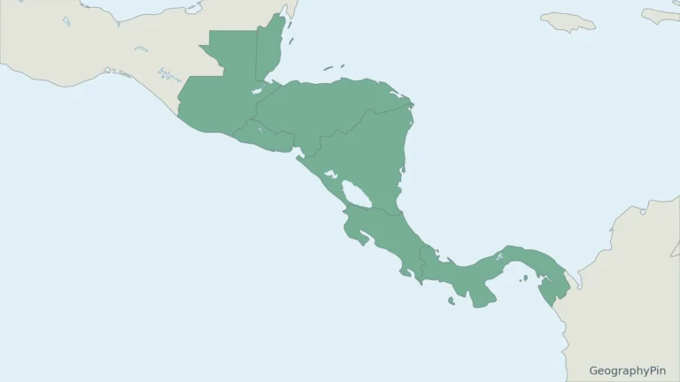
Panama is narrow enough to be crossed by an interoceanic canal, but its geography is more varied than that single route suggests. Western mountains, Pacific lowlands, wet Caribbean slopes and eastern forests occupy different parts of an isthmus that bends mainly from west to east.
Panama is the southeasternmost country of Central America, between Costa Rica and Colombia. Its isthmus links the North and South American landmasses while separating the Caribbean Sea from the Pacific Ocean. Panama City is the capital, on the Pacific side. The Panama Canal crosses the central isthmus using locks and reservoirs rather than an open sea-level channel.
How to use this article: Orient the land bridge and two coasts, compare the main landscapes, or explore the canal’s dependence on freshwater.
1. Locate Panama between two seas
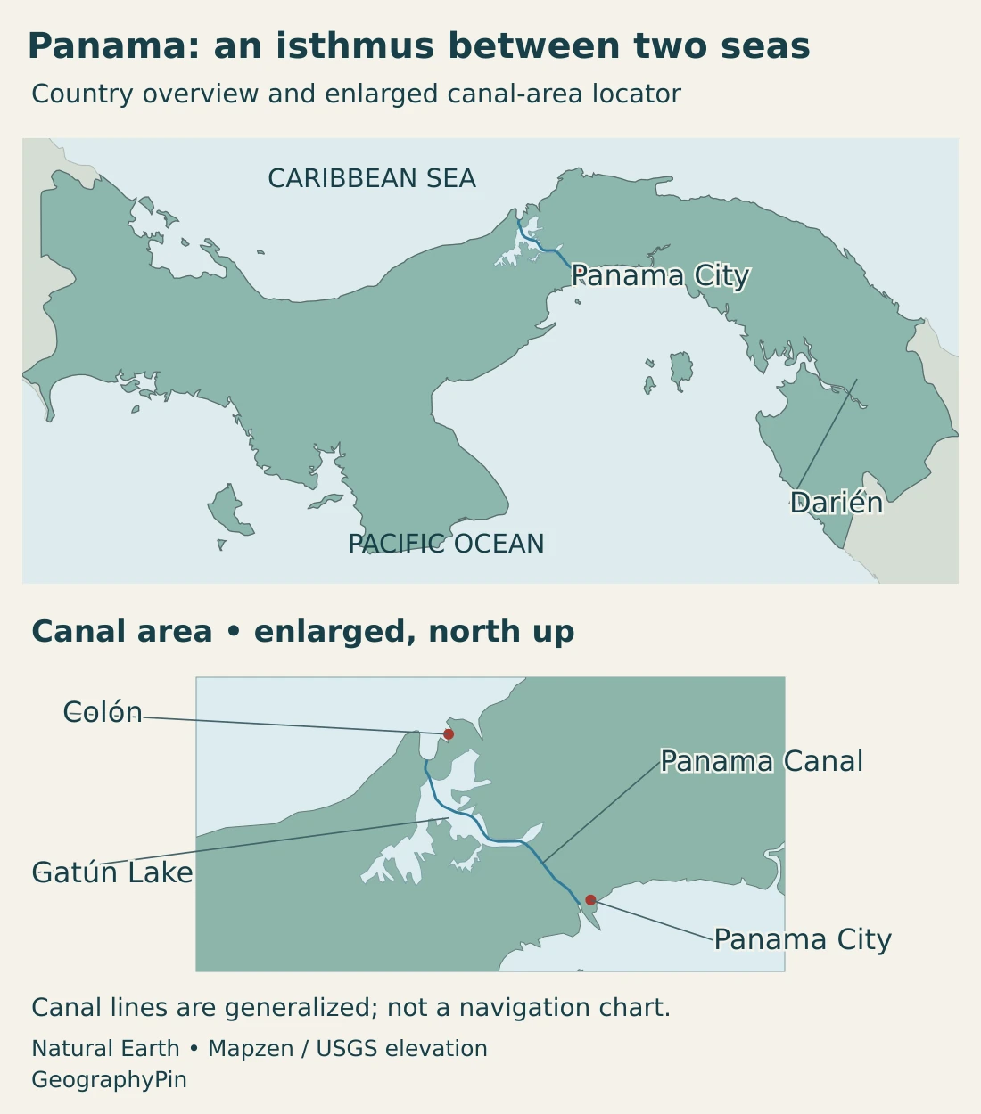
Panama borders Costa Rica to the west and Colombia to the east. Its northern coast faces the Caribbean Sea, part of the Atlantic system, while its southern coast faces the Pacific. The coastline bends, so those directions describe the broad national setting rather than every individual bay.
Central America, not a country split by the canal
Panama belongs to Central America, conventionally treated as part of North America in the seven-continent model. Colombia lies in South America. The canal is an engineered waterway, not the conventional continental boundary and not a border between two sovereign countries.
The isthmus is a land bridge in a physical and biological sense: land connects the American landmasses, while marine environments lie on opposite sides. “Separating two oceans” is shorthand for separating the Caribbean–Atlantic side from the eastern Pacific, not a claim that Panama divides the entire global ocean.
At the national scale, Panama extends mainly west to east. This is why its familiar map does not resemble a simple north–south corridor. Reading the coastline and the actual canal alignment is more useful than assuming that every Atlantic-to-Pacific transit must run directly east to west.
2. Country facts and Panama City
| Item | Detail |
|---|---|
| Capital | Panama City |
| Population | 4,645,375 in INEC’s projection for July 1, 2026, based on the 2023 census. |
| Published land-area figure | About 28,755 sq mi (74,474.2 km²), excluding water bodies in the INEC census-area table. |
| Official language | Spanish |
| Currency | Balboa (PAB), at parity with the U.S. dollar; the U.S. dollar is legal tender. |
| Administrative geography | Ten provinces, with Indigenous comarcas under special arrangements. |
| Coasts | Caribbean Sea and Pacific Ocean |
Population is a projection, not the raw 2023 census count. INEC’s area table excludes 1,142.5069 km² of water bodies and uses geographic data supplied by the Tommy Guardia institute; it is not a new 2026 survey. The rounded square-mile conversion follows that same land-area figure.
Panama City, the national capital, lies on the Pacific side near the canal’s southern end. Colón occupies the Caribbean-side setting. They have different locations and functions, even though the canal corridor connects their wider urban and port regions.
A figure for Panama province, Panama district or a metropolitan area is not automatically the population of Panama City. The national figure above uses its stated statistical coverage and reference date; it should not be compared with an urban figure without checking those definitions.
3. Highlands, lowlands and the central isthmus
A compact country with strong regional contrasts
| Setting | Landscape | Geographic importance |
|---|---|---|
| Western highlands | Mountain country around the Cordillera Central and Chiriquí. | Higher elevations bring cooler environments and divide drainage toward opposite coasts. |
| Central isthmus and canal corridor | Lower crossing terrain, hills and engineered reservoirs. | Connects the two coasts while concentrating transport and water-management infrastructure. |
| Pacific lowlands and Azuero | Coastal plains, valleys and the south-projecting Azuero Peninsula. | Includes agricultural landscapes with a more pronounced dry season than much of the Caribbean slope. |
| Caribbean slopes and islands | Wet coastal environments, hills and offshore island groups. | Links maritime settings with humid forest and coastal communities. |
| Darién and eastern ranges | Lowland and upland forests, rivers, mountains and coastal habitats. | Forms the eastern land connection toward Colombia, with landscapes very different from the urban canal corridor. |
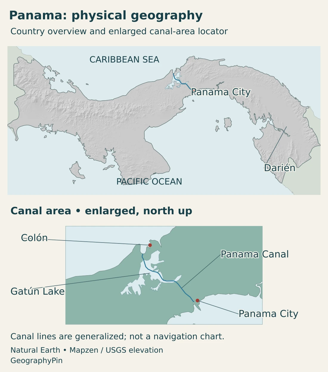
The Cordillera Central gives western Panama a mountainous backbone. Volcán Barú rises in this western setting and is the country’s highest mountain, reaching about 11,401 ft (3,475 m). Its elevation illustrates why a tropical latitude does not produce identical temperatures at every height.
The central crossing is lower than the western highlands, but it is not simply a flat gap at sea level. Canal construction required cuts through terrain, dams, reservoirs and locks. The landform and the engineered route should be read together.
Azuero projects south into the Pacific. Its hills and lowlands form a distinct setting within the broader Pacific side, rather than belonging to the canal watershed merely because they are in the same country.
Farther east, Darién contains both lowland and upland environments. UNESCO’s description of Darién National Park includes mangroves, swamps, rocky and sandy coasts, and tropical forests at different elevations. The region is not one uniform flat swamp, nor does the protected area represent every part of eastern Panama.
Island groups also matter on both sides of the isthmus. A country overview can show their geographic relationship to the mainland without treating a generalized small-scale outline as a complete inventory of every island or reef.
4. Rainfall, rivers and canal watersheds
Panama has a tropical climate with strong seasonal and regional rainfall contrasts. The national meteorological institute describes the rainy season broadly from May to November and the more noticeable dry period from December to April. The Caribbean side is an important exception: rain occurs through much of the year.
Mountain barriers, exposure to moist winds and elevation help explain the contrast between nearby places. Coastal lowlands are warm, while higher western locations are cooler. The Pacific-side dry season is therefore a more useful regional distinction than a claim that the whole country becomes uniformly dry for several months.
Rivers drain toward both the Caribbean and Pacific. The continental divide follows topography, not the canal’s shipping lane or an administrative border. The Chagres system is especially important to the canal’s water supply; eastern rivers such as the Tuira and Chucunaque belong to a different geographic setting.
Why rainfall matters to an ocean-to-ocean route
The Panama Canal is a lock canal. Vessels are raised above sea level to cross the reservoir-and-channel system and then lowered toward the other ocean. Gatún Lake is an artificial reservoir and a major part of the route, not a natural sea strait through the country.
Rain falling across the watershed supplies stored freshwater in Gatún and Alhajuela. That water supports canal operations and drinking-water supply for large urban populations. The canal therefore depends on conditions beyond the narrow channel visible between ships: surrounding catchments and reservoir storage are part of the operating system.
Lock operation, urban water supply and other uses create a shared management problem. A wet tropical climate does not guarantee unlimited water at every time of year. Rainfall variability and dry seasons can change the balance between inflow, storage and demand.
The legally defined Canal watershed and the water currently feeding individual reservoirs are related but not identical concepts. The Canal Authority’s present watershed description includes an expanded western area following a court ruling. A proposed reservoir or future water project should not be mistaken for an existing lake on a physical map.
Ownership and treaty history are separate questions. Our guide to who owns the Panama Canal covers that subject; here, the important geographic point is that an international shipping route depends on a nationally managed freshwater landscape.
5. People, provinces and Indigenous territories
Panama City and the central corridor combine national administration, transport and service activities. Colón occupies the other end of the crossing, facing the Caribbean. Their connection helps explain the importance of the central isthmus without making it representative of every rural or island community.
The national administrative framework includes ten provinces, divided into districts and corregimientos, alongside Indigenous comarcas with special legal arrangements. These comarcas do not all occupy the same administrative level. A simple count that treats every comarca as an ordinary province would misrepresent that structure.
Spanish and the country’s linguistic diversity
Spanish is the official language under Article 7 of the Constitution. Indigenous languages are also spoken, including languages associated with Guna, Ngäbe, Buglé, Emberá, Wounaan and Naso communities. The official-language rule does not make the country linguistically uniform.
Indigenous territories and communities are part of Panama, not separate sovereign countries. Their legal arrangements should be distinguished from the broad physical regions used in this article. A mountain range, a watershed, a province and an Indigenous comarca can overlap without referring to the same kind of boundary.
6. Government and an economy of connections
Panama is a sovereign unitary republic. Its constitutional framework separates legislative, executive and judicial organs. Panama City is the national capital; neither Colón nor the canal’s administrative facilities constitutes a separate national capital.
The canal corridor is a clear example of geography shaping economic activity. Ports and transport services connect the two coasts, while ships use the canal to avoid much longer sea routes. The corridor’s value comes from the relationship between location, engineered infrastructure and dependable water supply, not location alone.
Yet Panama’s economy cannot be reduced to canal transits. Azuero offers a different example: the Ministry of Agricultural Development’s 2026 work with maize producers describes attention to sowing dates, soils and local growing conditions. These are the practical concerns of an agricultural landscape, quite different from those of a port terminal.
Western highlands and eastern forest regions also present different environmental settings for settlement and land use. Elevation, rainfall, terrain and accessibility influence what activities are possible and how communities connect to markets.
The country’s coast-to-coast role brings a further distinction: a shipping route crossing Panama is not the same as a continuous natural marine passage. The land bridge still separates the two marine environments, while the canal provides a controlled route through locks and freshwater reservoirs.
Panama’s geography is best understood through these overlapping systems. The national territory connects continents; the canal connects shipping routes; watersheds connect rainfall with reservoirs and cities. None of those systems has exactly the same boundary, and each explains a different part of the country.
Frequently Asked Questions
Is Panama in North America or South America?
Panama is in Central America, conventionally included in North America in the seven-continent model. It borders Colombia in South America. The canal is not the conventional continental boundary.
Is the Panama Canal a sea-level channel?
No. It uses locks to raise and lower vessels through a route that includes Gatún Lake and excavated channels. Freshwater storage is essential to the system.
Does Panama have the same dry season on both coasts?
No. A pronounced dry period affects much of the Pacific side, broadly from December to April, while the Caribbean side receives rain through much of the year. Local conditions vary.
What Did We Learn Today?
Panama is a Central American land bridge with Caribbean and Pacific coasts. Its western mountains, Pacific lowlands, central canal corridor and eastern forests create distinct environments. Panama City is the capital, and the canal crosses the isthmus through locks and reservoirs. Rainfall and watershed management are therefore as important to the crossing as the country’s narrow shape.
Sources & Data Notes
Population and area use separately stated definitions and reference dates. The canal’s shipping route, reservoir catchments and legal watershed are distinct geographic concepts. Reviewed in November 2026.
- INEC, population projections by province and comarca: Revised projection series: July 1, 2026 total of 4,645,375. The statistical series is distinct from the raw census enumeration.
- INEC, census population and geographic-area table: Table 4: 74,474.2 km², with the footnote explicitly excluding water bodies; geographic data supplied by Instituto Geográfico Nacional Tommy Guardia.
- IGN Tommy Guardia, administrative geography metadata: Official geographic metadata distinguishes Indigenous comarcas at different administrative levels.
- Electoral Tribunal, current Constitution: Articles 1–2, 5 and 7: state structure, administrative framework and official language.
- UNData, Panama country profile: Capital and regional classification. The national INEC series supplies the population and scoped area used here.
- ICAO, Panama meeting information 2026: Balboa parity and the U.S. dollar’s legal-tender role.
- Panama Tourism Authority, national guide-study manual: Pages 14–15: mountain and lowland geography, Volcán Barú, rivers and language diversity.
- IMHPA, Panama rainfall regime: Broad rainy and dry seasons, with the Caribbean-side exception.
- IMHPA, general climate description: East–west isthmus orientation, maritime influences, relief and regional climate.
- UNESCO, Darién National Park: The eastern land bridge and the park’s variety of coastal, wetland and forest habitats.
- Panama Canal Authority, how the canal works: Lock operation, Gatún Lake and the excavated crossing. Historic original-lock specifications are not treated as specifications for all present-day locks.
- Panama Canal Authority, water and the canal: Reservoir storage, public water supply and the legally defined watershed. Projected infrastructure is not represented as an existing lake.
- MIDA, maize production in Azuero: June 2026 account of agricultural work in Azuero, including planting dates, soils and field conditions.
Map sources and scope: Original GeographyPin maps use public-domain Natural Earth country outlines, source islands, city coordinate attributes, lake polygons and canal lines. All Panamanian source components are retained; small islands are generalized and this is not a complete island inventory or official boundary chart.
The canal-area inset preserves the source geometry and city positions, but is enlarged at a different scale from the overview and remains north-up. It is a flat locator even on the physical map. Gatún Lake and both source canal-line records are generalized reference features, not current water levels, comprehensive modern lock approaches or navigation guidance. The Canal Authority describes the Culebra Cut’s crossing of the continental divide; no invented or surveyed divide line is drawn here. Darién is a broad location label, not a park or province perimeter.
Main-map hillshade is calculated from real elevations accessed through Mapzen Terrain Tiles. Global elevation data courtesy of the U.S. Geological Survey. Elevation-source attribution and terms apply. Shading represents terrain form, not numerical elevation bands or local navigation detail.
The cover uses Panama flag artwork by Zscout370 and Commons contributors as an outline motif alongside an intact flag, decorative divider and GeographyPin branding.