Antarctica
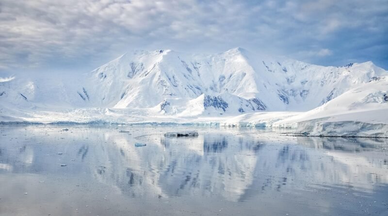
Antarctica is the highest, driest, and coldest continent, a polar desert covered by an ice sheet averaging about 1.34 miles (2.16 kilometers) thick. It stores ~30 million km³ (7.2 million mi³) of ice—enough to raise seas ~190 feet (58 meters) if fully melted. No nation owns it; activity is governed by the 1959 Antarctic Treaty.
Antarctica at a Glance
Antarctica covers almost 5.4 million square miles (≈14 million square kilometers), making it the world’s fifth-largest continent. Nearly all of it is buried under the Antarctic Ice Sheet, which is up to ~3.0 miles (4.9 kilometers) thick in places and contains roughly 30 million cubic kilometers (7.2 million cubic miles) of ice. Its average surface elevation is about 8,200 feet (2,500 meters)—the highest of any continent—because ice is literally stacked atop the land.
Antarctica’s highest peak is Mount Vinson at 16,050 feet (4,892 meters) in the Ellsworth Mountains; its coldest reliably measured air temperature is −128.6°F (−89.2°C) at Vostok Station on 21 July 1983. The continent is encircled by the Southern Ocean, now formally recognized by major authorities, including NOAA and the International Hydrographic Organization (IHO).
Where is Antarctica and what counts as the “Southern Ocean”?
Antarctica spans everything south of 60°S. In 2021 National Geographic and, in 2023, the IHO reaffirmed the “Southern Ocean” as the waters surrounding Antarctica with a northern limit at 60°S. This clarifies mapping and science while aligning with how oceanographers trace currents like the Antarctic Circumpolar Current.
| Metric | Value (as of 2025) |
|---|---|
| Area (land & ice) | ≈5.4 million sq mi (≈14 million km²) |
| Average elevation | ≈8,200 ft (≈2,500 m) |
| Ice sheet average thickness | ≈1.34 mi (≈2.16 km) |
| Maximum ice thickness | ≈3.0 mi (≈4.9 km) |
| Ice volume (sea-level equivalent) | ≈30 million km³ (≈7.2 million mi³) ≈ 190 ft (≈58 m) SLR |
| Highest point | Mount Vinson, 16,050 ft (4,892 m) |
| Coldest measured air temperature | −128.6°F (−89.2°C), Vostok, 1983 |
| Parties to the Antarctic Treaty | 58 Parties total; 29 Consultative Parties |
| Seasonal population (research) | ~10,000 in summer; ~950 over winter (approx.) |
Sources: NSIDC; Australian Antarctic Division; British Antarctic Survey; WMO; ATS; COMNAP; Britannica.
Landscape, Ice & Climate
Antarctica is split by the Transantarctic Mountains into East and West Antarctica. East Antarctica is the larger, high-elevation polar plateau; West Antarctica includes marine-based ice resting below sea level in places. The ice sheet flows outward under its own weight, feeding floating ice shelves such as Ross and Filchner-Ronne. The bedrock and ice thickness have been mapped in detail by the international BEDMAP projects, confirming mean ice thickness a little over 2 kilometers (≈1.24 miles) and maxima near 4.9 kilometers (≈3.0 miles).
Temperatures are brutal. The World Meteorological Organization (WMO) confirms the world’s coldest measured air temperature at Vostok Station: −89.2°C (−128.6°F) on 21 July 1983. Meanwhile, satellites have detected even colder surface “cold pools” on the East Antarctic Plateau during clear, still winter nights.
Why Antarctic sea ice behaves differently from the Arctic
Unlike the Arctic Ocean (an ocean hemmed in by land), Antarctica is a continent surrounded by ocean. Sea ice has “room to breathe” in winter, then retreats far toward the coast in summer. Seasonal sea-ice thickness is generally ~3–6 feet (1–2 meters), much thinner than multi-year Arctic ice.
Since 2017, Antarctic sea ice has shown record-low extents. On 20 February 2024, the summer minimum tied for second lowest in the satellite record at ~768,000 square miles (1.99 million km²); in 2025 the minimum was again among the four lowest on record—marking four consecutive lows since 2022. These swings are still being studied, but warmer oceans and shifting winds are likely contributors. See NSIDC analysis for details.
Mass balance—the net gain or loss of ice—matters for sea level. The IMBIE consortium’s reconciled satellite record indicates the Antarctic Ice Sheet lost ice overall from 1992–2020, contributing to global sea-level rise with an average loss rate that increased over time, and recent GRACE/GRACE-FO estimates point to losses on the order of ~150 gigatons per year since 2002.
Life on the Ice
Antarctica looks empty, but its surrounding seas teem with life. Antarctic krill form the base of a rich food web that supports penguins, seals, and whales. On land, only a handful of hardy plants (mosses, lichens) and invertebrates survive the polar desert. Marine birds and mammals time their breeding to sea-ice cycles and summer productivity.
Iconic penguins include emperor, Adélie, chinstrap, and gentoo. Their colonies cluster where sea ice, open water, and rocky land meet. Fishing and conservation in these waters are managed through the Commission for the Conservation of Antarctic Marine Living Resources (CCAMLR), a pillar of the Antarctic Treaty System that sets catch limits and marine protected areas to keep ecosystems healthy.
Human Footprint & Science
No one lives permanently in Antarctica. Instead, dozens of nations operate research stations. The largest logistics hub is McMurdo Station (U.S.), and at the Pole itself the Amundsen-Scott South Pole Station hosts astronomy and climate experiments at ~9,301 feet (2,835 meters) elevation. Population varies seasonally—about 10,000 people in summer and around 950 “winter-overs” remain through the polar night, according to COMNAP.
Stations, field camps, and ice runways are supported by ships, aircraft, and over-snow traverses. International collaboration is the norm: data sharing, joint expeditions, and common environmental rules help minimize impacts while maximizing science—glaciology, seismology, astrophysics, and more. Explore the station map via COMNAP’s public facilities portal.
History & Governance
Antarctica entered the modern age of exploration in the 1800s, but the big pivot came during the International Geophysical Year (1957–1958), when many nations built stations and coordinated polar science. On 1 December 1959, 12 countries signed the Antarctic Treaty in Washington; it entered into force in 1961. The Treaty demilitarizes the continent, guarantees freedom of scientific investigation, and suspends sovereignty disputes. Today there are 58 Parties (as of 2025).
Environmental protection was deepened by the Protocol on Environmental Protection (Madrid Protocol, 1991; in force 1998). It designates Antarctica as a “natural reserve, devoted to peace and science,” bans mineral resource activities (except for scientific research), and requires rigorous environmental impact assessment. Read the Antarctic Treaty Secretariat for the legal texts and meeting documents.
Who gets a say? Consultative vs. non-consultative parties
Parties that demonstrate substantial scientific activity in Antarctica are granted “Consultative” status; they draft and adopt measures by consensus at annual meetings. As of 2025 there are 29 Consultative Parties within the 58 total Treaty Parties. Non-Consultative Parties may attend but do not participate in decision-making.
Visiting Responsibly
Tourism occurs mainly from November to March (austral summer) by ship or small aircraft, with strict rules to protect wildlife and sites. Visitors travel with operators that follow guidelines akin to those promoted by IAATO—limited group sizes, biosecurity boot washes, no feeding wildlife, and careful distance rules for penguin and seal colonies. Conditions can change quickly; even in summer, katabatic winds and sea-ice conditions can disrupt plans. (Consult IAATO and national programs for current procedures.)
FAQ
Is Antarctica a country?
No. Antarctica has no sovereign government or citizens. It is managed collectively through the Antarctic Treaty System, which sets rules for peaceful use, science, and environmental protection.
How cold does it really get?
The coldest reliably measured air temperature on Earth is −128.6°F (−89.2°C), recorded at Vostok Station on 21 July 1983. Wind chill can make it feel even colder.
Is Antarctic sea ice shrinking every year like the Arctic?
Antarctic sea ice varies a lot year-to-year, but since 2022 the annual summer minimums have been the four lowest in the satellite record, pointing to unusual conditions. Scientists are investigating links to ocean warming and wind patterns.
What Did We Learn Today?
- Antarctica holds ~61% of Earth’s fresh water in ice—~30 million km³ (7.2 million mi³)—with sea-level rise potential of ~58 meters (190 feet) if fully melted.
- The world’s coldest measured air temperature is −89.2°C (−128.6°F) at Vostok (1983).
- Antarctic sea ice hit a near-record summer low in 2024 and remained extremely low in 2025, part of a recent string of record minima.
- There are no permanent residents; seasonal research populations peak ~10,000 in summer and ~950 in winter across international stations.
- The Antarctic Treaty (1959/1961) keeps the continent for peace and science; 58 Parties (29 consultative) govern by consensus, with strong environmental rules.