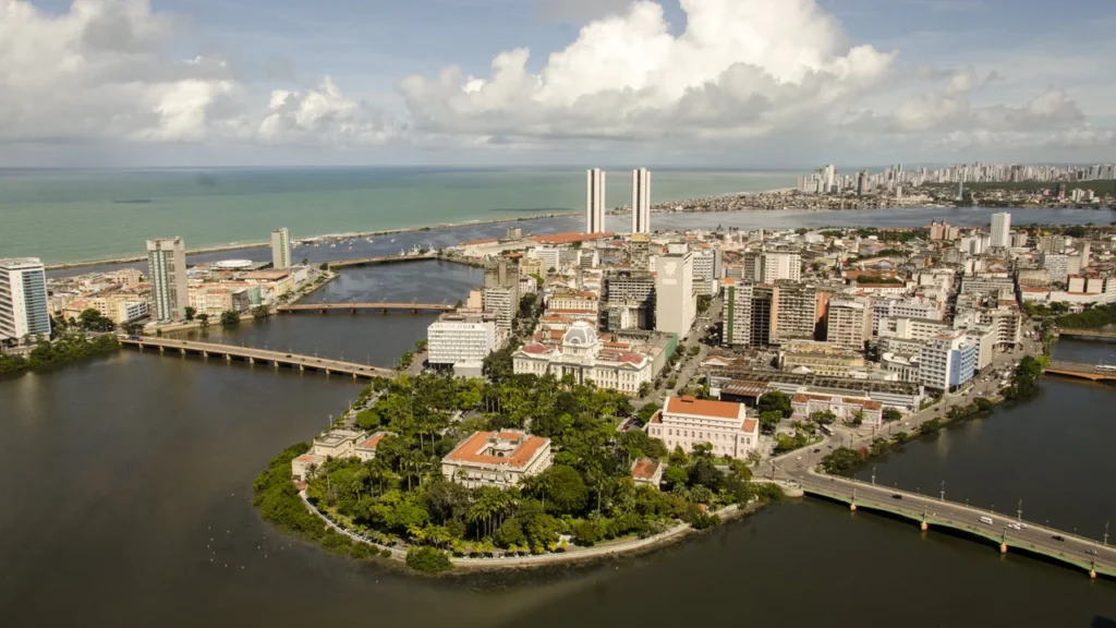
Recife is the capital of Pernambuco, on Brazil’s northeastern Atlantic coast. The city’s old port and neighboring historic districts grew around a tidal meeting of rivers, rather than on a single stretch of mainland.
Bridges connect several parts of central Recife that sit on different banks and islands. Near the old harbor, the northern branch of the Capibaribe meets the Beberibe. Other channels separate Recife Antigo, Antônio Vaz and the mainland, so a short trip across the center may cross more than one bridge.
How to use this article: Try the city boundary map, see the reef-sheltered harbor, or go to the city and metropolitan populations.
The city and its municipal limits
Follow the boundary beyond the port
Start with the rust-colored line on the map. It encloses the municipality of Recife, taking in much more than the old harbor and the coastal skyline. The wider metropolitan region, shown with a dashed edge, reaches north through Goiana and south through Ipojuca. Neither the city line nor the metropolitan line is simply the edge of the buildings.
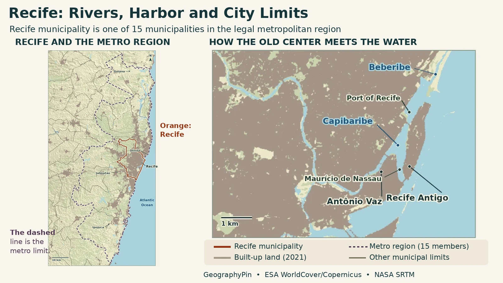
The developed stretches around Recife, Olinda and the municipalities to the south are easier to see from the gray overlay. That layer records built-up land under the 2021 WorldCover classification, not population or commuting. Where developed land seems to run across a line, a person can leave Recife municipality without leaving the urban area.
How the Capibaribe divides in central Recife
Two branches, different paths toward the water
The Capibaribe approaches from the west and divides in central Recife. Its northern branch winds past the center toward the Beberibe. The southern arm runs through the Afogados and Ilha do Retiro side toward Ilha Joana Bezerra and joins the Tejipió system before reaching the port area. The two branches help explain why the downtown water does not look like one clean river channel on a street map.
Antônio Vaz, the historic island associated with the districts of Santo Antônio and São José, is not the same as the old port neighborhood. On the detail map, start at the Maurício de Nassau Bridge. Its two ends face different parts of the historic center: Santo Antônio on the west and Recife Antigo on the east.
Where the Beberibe joins the city’s waterways
The junction is inland of the open Atlantic
The Beberibe drains the north side of Recife. It meets the northern Capibaribe arm in the basin of Santo Amaro, inland of the harbor entrance. The meeting helps explain the broad spread of water on the northern side of the center, while closer to the old port the bridge crossings run across narrower channels. These are different points on the same estuarine system.
Names can be misleading at this scale. Recife Antigo is the common name for the Bairro do Recife, the port-side neighborhood, not all of central Recife. Antônio Vaz and Boa Vista belong to the story of the historic center too, even though they are on the other side of one or more crossings.
Why the reefs mattered to the harbor
Sheltered water on an exposed coast
The port authority describes a natural shelter formed by reefs and strengthened by built breakwaters. At the sculpture park across the harbor from Marco Zero, geologists documented beachrock, sand hardened by carbonate cement. Banco Inglês is a separate offshore breakwater. Not every wall or exposed strip in a harbor photograph is untouched rock.
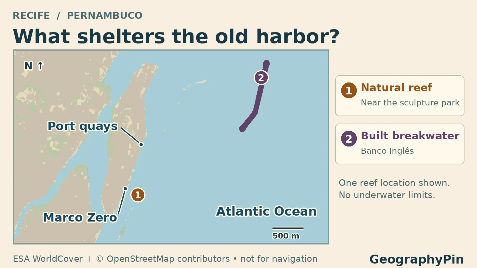
Recife’s early port activity took advantage of this protected setting. The city-and-metro map identifies the port area; the harbor detail above marks one documented reef site and one built structure. Neither figure tells you what is exposed at a given tide.
Where the city ends and the metro begins
Compare populations using one census
Recife municipality had 1,488,920 residents in the 2022 census. To put it alongside a comparable metro figure, add the 2022 populations of the 15 municipalities named in Pernambuco’s law for the Região Metropolitana do Recife. That gives 3,808,029, including Recife itself.
| Area counted | Residents |
|---|---|
| Recife municipality | 1,488,920 |
| Legal Recife Metropolitan Region (15 municipalities including Recife) | 3,808,029 |
Olinda and Jaboatão dos Guararapes are separate municipalities even where settlement runs together. Farther away, Goiana still counts in the legal region. That is a useful limit on the term “metro”: this total includes all inhabitants of the member municipalities, not only those inside one continuous patch of development.
IBGE also studies arranjos populacionais, groupings based on commuting links for work or study or continuity of built-up land. Those are a different statistical geography. The table uses the state-law planning region so readers can match its total to the dashed boundary.
Frequently Asked Questions
Which part of the harbor barrier is a natural reef and which is a breakwater?
The beachrock near the sculpture park is a naturally hardened deposit. The separately marked Banco Inglês breakwater is built infrastructure. The port authority credits natural reefs and engineered works with sheltering the harbor.
Does Olinda belong to Recife municipality?
No. Olinda is its own municipality immediately north of Recife. Both belong to the legal Recife Metropolitan Region, and their built-up areas meet near the municipal line.
Is the coast at Boa Viagem the same waterfront as the old harbor?
No. Boa Viagem is on Recife’s Atlantic-facing southern coast. Recife Antigo is farther north, beside the older sheltered port and the river channels of the historic center.
What Did We Learn Today?
Recife’s bridges make sense once you separate the river branches, the harbor and the coast. Two rivers meet near the old districts, and coastal reefs and breakwaters shelter the port. The municipal boundary covers a wider area than that historic core, but the legal metro region takes in 14 other municipalities as well.
Sources & Data Notes
IBGE municipal polygons and the population count use 2022. The metropolitan boundary is the union of the 15 members named in Pernambuco Complementary Law 382/2018, checked against the state’s membership list. The gray built-up class is not an estimate of population. © ESA WorldCover project 2021 / Contains modified Copernicus Sentinel data (2021) processed by ESA WorldCover consortium.
- IBGE: official Recife municipality population and identifier
- IBGE SIDRA table 4714: 2022 census population; sum of all 15 member municipalities
- IBGE: 2022 municipal mesh for Pernambuco
- Pernambuco Complementary Law 382/2018: definition and membership of the Recife Metropolitan Region
- Pernambuco Condépe/Fidem: 15 municipalities shown in the legal region
- IBGE: distinct commuting or built-continuity grouping method
- Recife Official Gazette, May 14, 2026: lower Capibaribe branches, Beberibe and Santo Amaro basin
- Recife Municipal Law 16.293: waterways and named crossings
- City of Recife: surveyed reference points PD-06 and PD-07 at Maurício de Nassau Bridge
- Waterway label positions verified against © OpenStreetMap contributors (ODbL); water extent is WorldCover
- Recife tourism authority: Bairro do Recife and its port history
- Port of Recife: reefs and protection by breakwaters
- Port of Recife: natural sandstone-limestone reef description
- ESA WorldCover 2021 (CC BY 4.0), mapped water and class 50 built-up land
- Terrain: Mapzen Terrain Tiles / NASA SRTM and source attribution
- Featured image credit: Portal da Copa/ME, Antônio Vaz, July 12, 2012; cropped and converted
- Photo license: Creative Commons Attribution 3.0 Brazil
- Harbor detail: © ESA WorldCover project 2021 / contains modified Copernicus Sentinel data (2021) processed by ESA WorldCover consortium, reclassified and recolored for this figure (ESA WorldCover 2021 v200, CC BY 4.0). Banco Inglês geometry: © OpenStreetMap contributors (ODbL data). Reef locality: SIGEP Arrecifes geosite study, fig. 9 and Recife city points PM-94 and PM-95. The Brazilian Navy lights publication was consulted to corroborate the structure identification and was not reproduced.