The São Francisco stays a large river even where many smaller streams in Brazil’s dry interior flow only in the wet season. The reason starts well upstream, in wetter parts of the country that send water into the channel long before it reaches the Atlantic.
The São Francisco starts in the Serra da Canastra area of Minas Gerais, flows north into Bahia and bends east through Brazil’s semi-arid interior. It reaches the Atlantic between Alagoas and Sergipe. Wetter upstream areas supply much of its water, and reservoirs such as Sobradinho regulate the flow downstream.
How to use this article: Start with the two length conventions, then locate the Canastra branch, follow the water through the sertão and find the Atlantic mouth.
Where the São Francisco begins and ends
The São Francisco is a Brazilian river with a long inland course before it reaches the coast. It starts in the high country of Minas Gerais, runs broadly north into Bahia and then turns east, ending at the Atlantic on the Alagoas–Sergipe boundary.
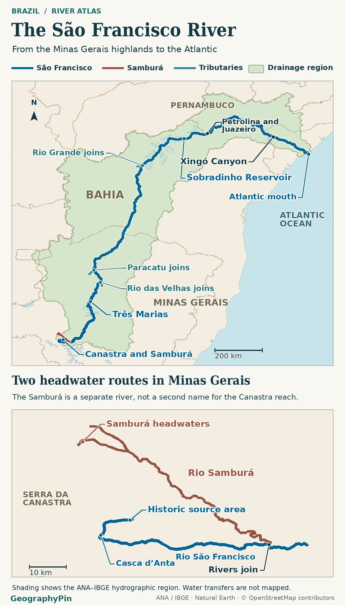
Compare two ways to measure the river
Brazil’s federal development agency Codevasf measures about 1,749 miles (2,814 km) from the historic source in the Serra da Canastra, or 1,779 miles (2,863 km) if the route starts farther up the separate Samburá branch near Medeiros. Both figures end at the same coast. The longer route starts on a named tributary, so the map distinguishes the Samburá from the São Francisco itself.
The river’s basin covers about 246,000 square miles (636,000 km²) in the Codevasf inventory. The basin committee gives about 247,000 square miles (639,000 km²). Those are published estimates from different inventories, not measurements of the area of the blue river line or reasons to redraw the watershed by hand.
Minas Gerais: headwaters and the first big tributaries
Locate the Canastra branch
The route from the traditional source crosses the Serra da Canastra highlands near São Roque de Minas. At Casca d’Anta the young river drops over a rocky escarpment. Farther down, the São Francisco and Samburá join well upstream of Três Marias. The waterfall belongs to the traditional source route, not to the alternate Samburá headstream.
After Três Marias and Pirapora, the river gathers water from tributaries that reach far into the Brazilian interior. The Rio das Velhas approaches from the east and the Paracatu from the west. Farther north in Bahia, the Rio Grande joins at Barra, upstream of Sobradinho Reservoir. The tributary lines explain why rainfall far from the riverbank matters.
How the river crosses the semi-arid interior
Follow the water through the sertão
Much of the basin’s water comes from wetter areas of central Brazil and Minas Gerais. Tributaries carry that runoff into the São Francisco before and along its route through drier country. In the semi-arid sertão, some smaller rivers flow only part of the year, but the São Francisco carries water from a much larger area than the land right beside its banks.
Sobradinho Reservoir, upstream of the neighboring cities of Juazeiro and Petrolina, makes a second difference. It stores upstream water and its outlet can release more or less than is arriving at that moment. On October 10, 2022, Brazil’s water agency ANA reported about 27,500 cubic feet per second (780 m³/s) entering Sobradinho and 46,800 cubic feet per second (1,325 m³/s) leaving it. This is a dated inflow-and-release comparison, not a guaranteed flow for downstream towns.
From Xingó Canyon to the Atlantic outlet
Find the mouth below the canyon
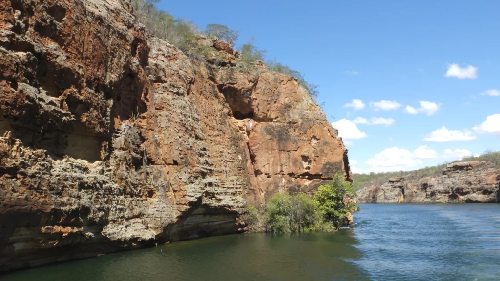
East of the inland reach, the river passes a chain of dams and the rock-walled, partly impounded Xingó Canyon. It continues beyond Xingó through the lower valley and past Propriá, then reaches the Atlantic between the municipalities of Piaçabuçu in Alagoas and Brejo Grande in Sergipe. The coastal mouth is downstream of both town centers.
At the coast, the river opens between sandy shores affected by tides and waves. The delta does not have a fixed shoreline: severe erosion by the late 1990s submerged much of the community of Cabeço on the Sergipe side. Field and shoreline studies identify waves and reduced sediment supply as factors. An outline of today’s river network should not be read as permanent land at the mouth.
What the basin boundary leaves out
The named river touches five Brazilian states: Minas Gerais, Bahia, Pernambuco, Alagoas and Sergipe. The larger drainage area also reaches Goiás and the Federal District. Conversely, there are places outside the natural basin supplied by engineered transfers. The federal São Francisco Integration Project takes water near Cabrobó for its North Axis and from the Itaparica reservoir for its East Axis. A canal carrying water out of the watershed does not extend the natural river’s mapped course.
ANA’s October 13, 2022 bulletin lists October 10 mean flows of about 47,000 cubic feet per second (1,330 m³/s) at the Juazeiro station and 40,600 cubic feet per second (1,149 m³/s) at Propriá. These are readings for different reaches with reservoirs and tributaries in between, not a measurement of how much water one cause removed. Codevasf’s approximately 105,000 cubic feet per second (2,980 m³/s) annual mean at the mouth is a separate statistic, not a competing reading for that day.
Frequently Asked Questions
Which side of the São Francisco are Petrolina and Juazeiro on?
Petrolina is on the north bank in Pernambuco; Juazeiro is across the river in Bahia. The Presidente Dutra Bridge links them at the state boundary.
What does Velho Chico mean?
It means “Old Chico”; Chico is a familiar form of Francisco in Portuguese. On Brazilian signs and in local accounts, Velho Chico is a nickname for the same river.
Do the project canals mean the São Francisco flows through Ceará or Rio Grande do Norte?
No. The river’s own channel does not run through either state. Parts of both are served through the transfer project and connected water systems, which carry some of its water beyond the natural basin.
What Did We Learn Today?
The São Francisco can cross dry country because the river gathers water from wetter parts of a much larger basin, then carries it onward through regulated reaches. The historic Canastra branch and longer Samburá route lead into the same main channel and reach the same Atlantic outlet.
Sources & Data Notes
Codevasf’s inventory distinguishes the two source conventions and lists the basin area and mouth mean; the basin committee uses a slightly different basin area. Minas Gerais water-planning documents identify the Samburá junction; the Geological Survey of Brazil describes Casca d’Anta’s escarpment and maps the Minas Gerais tributaries; Bahia’s state survey maps the Rio Grande junction. Brazil’s road agency identifies the bridge and state line. The Ministry of Integration uses the Velho Chico nickname, identifies the transfer’s recipient states, explains where basin runoff is generated and documents the transfer intakes.
Discharge examples use ANA’s October 13, 2022 bulletin, page 3. ANA labels the bulletin’s figures preliminary and subject to checks; US customary conversions and area values are rounded. The Piaçabuçu protected-area decree describes the Alagoas side of the outlet; the coastal wave and sediment study and the shoreline-change study support the Cabeço example.
Featured photograph: Navegando pelos Cânios de Xingó, Daniel Wander, April 17, 2015, CC BY-SA 4.0. Minimally cropped, resized and converted to WebP; the adaptation remains under CC BY-SA 4.0.
Prepared for final factual and editorial review by Zurab Koniashvili (Z.K. Atlas). AI tools assisted with editorial preparation.
Map: GeographyPin. Original GeographyPin cartography. Hydrographic region adapted from ANA–IBGE’s open Regiões Hidrográficas dataset (DHN250), with upstream linework from ANA’s Ottocoded hydrographic drainage network. ANA’s SNIRH data policy describes its open data portal as providing machine-readable data for free access without licence restrictions. Some river geometry © OpenStreetMap contributors (ODbL), general coastline, lakes and administrative lines from Natural Earth. The boundary and channel layers were selected, generalized and rendered together; no official source map pixels are reproduced.