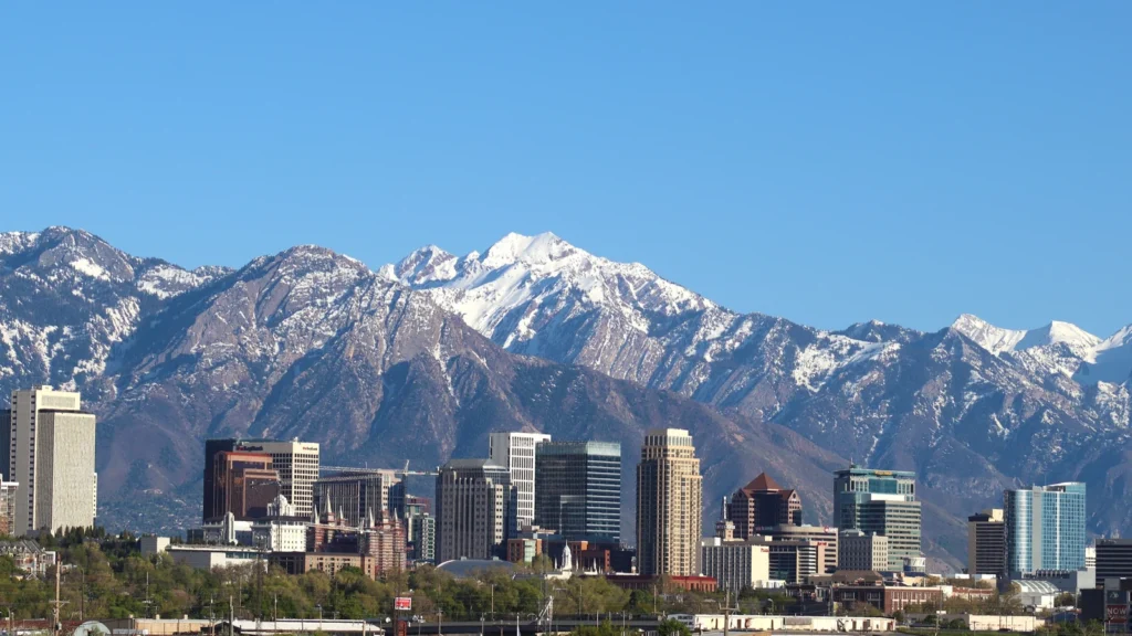
Salt Lake City is Utah’s capital, at the north end of the Salt Lake Valley. The Wasatch Mountains rise just east of the city, while the Great Salt Lake lies beyond the lower ground to the west and northwest. The lake gave the city its name, but downtown is not on its shore.
Salt Lake City sits between mountains and lake
Salt Lake City is in northern Utah, east and southeast of the Great Salt Lake and at the western foot of the Wasatch Range.
Downtown sits east of the Jordan River. The city limits reach much farther west than downtown, and the lake’s wet shoreline shifts as water levels rise and fall.
How to use this article: Read the city’s two map scales, follow the Jordan River from Utah Lake, or compare downtown’s distance from the lake and the marina.
Where Salt Lake City sits on the map
Find the city at two different scales
At the state scale, locate the Great Salt Lake in north-central Utah, then find Salt Lake City at the lake’s southeastern side. At city scale, the points spread out: the downtown street grid is east of the Jordan River, the airport is farther west, and the foothills rise on the east. The City and County Building at 451 South State Street gives the downtown distances below a named starting point.
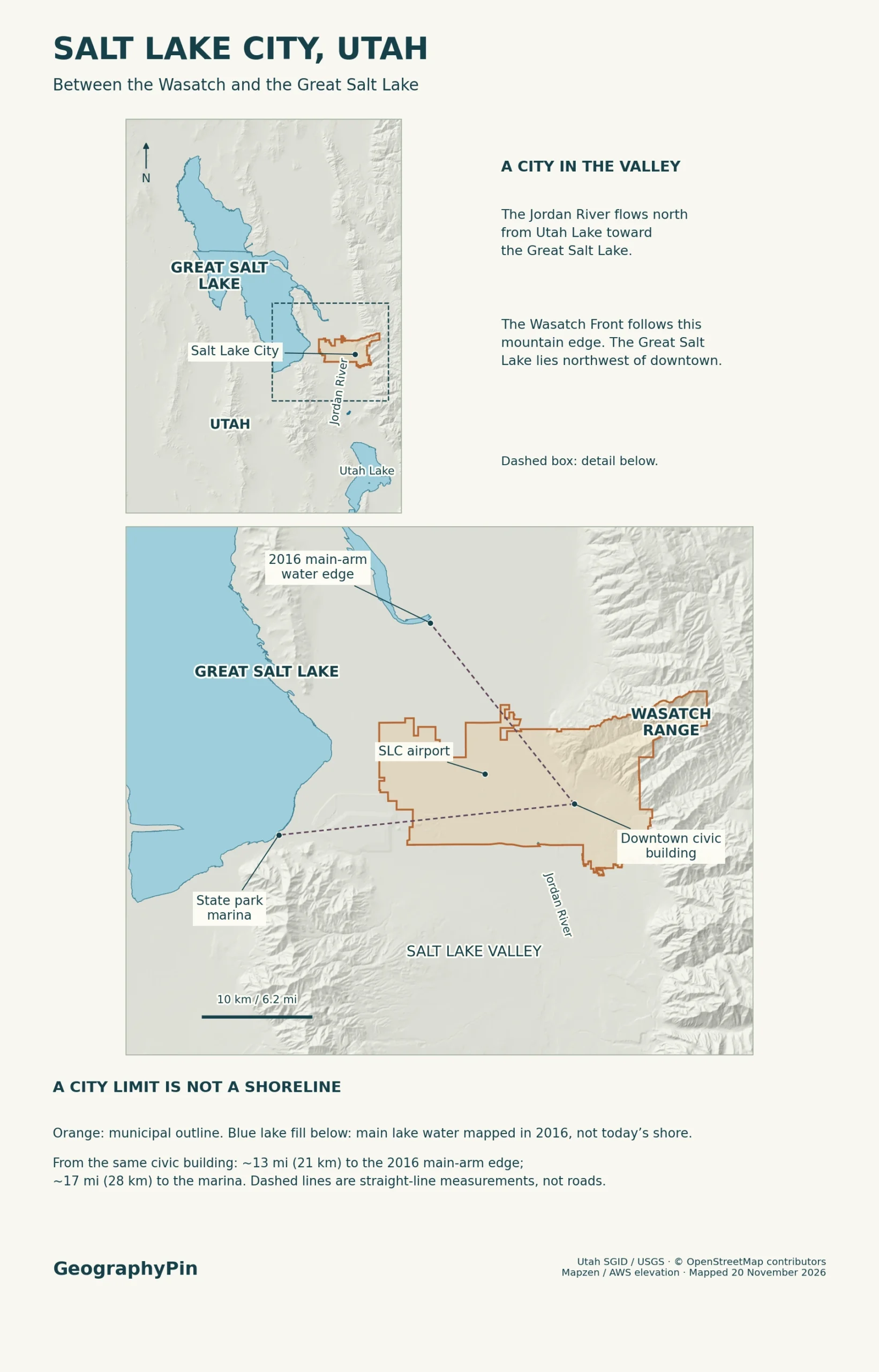
The municipal outline is not the outline of the built-up area. It includes industrial land and shorelands in the western Northwest Quadrant, not just the neighborhoods around downtown. Nor does it include every settlement in the Salt Lake Valley. Salt Lake County contains several separate cities, including Salt Lake City, South Salt Lake and West Valley City.
The Wasatch Front and the foothills
The Wasatch Range is the line of mountains east of the city. The Wasatch Front is the western front of that range and, in regional planning, the much wider urban corridor running along it. A regional map can include Ogden and Provo as well as Salt Lake City without claiming that all three lie inside one municipality or even one valley.
The steep mountain front and the flatter basin are connected. Utah Geological Survey research explains how fault movement raised mountain blocks relative to the valley floor. The fault zone is not just one line at today’s first steep slope: mapped branches include the East Bench fault near the University of Utah. That distinction matters if you compare a street map with a geology map.
Some low benches are older shorelines rather than faults. When freshwater Lake Bonneville covered much of western Utah, waves cut ledges and moved sediment around the basin. The Utah Geological Survey identifies a former Stansbury shoreline terrace just below the Utah State Capitol. The bench helps explain how a lake left a mark on land well above the Great Salt Lake today.
The Jordan River across the valley floor
Follow the Jordan River north from Utah Lake
Utah Lake, south of Salt Lake City, drains north through the Jordan River. The river passes through the Jordan Narrows and across the Salt Lake Valley before its water reaches Great Salt Lake wetlands and bays. Seen on a regional map, the flow is from the freshwater lake toward the salt lake, not the other way around.
In Salt Lake City the river runs west of downtown through Westside neighborhoods. The Jordan River Parkway follows it and makes the corridor easier to recognize on a street map. The river and the paved trail have different routes and lengths. In the lower valley, diversions and canals also move water, so the one line on a small map cannot show every way that water reaches the lake.
The Great Salt Lake has no river outlet to the ocean. Water can leave by evaporation, while dissolved salts delivered by its watershed stay behind. That is why a river feeding the lake does not have to be salty itself.
How close downtown is to the Great Salt Lake
Compare a mapped shore with a place you can navigate to
There is no fixed figure for how far downtown is from the modern wet shoreline. It depends on the day, the downtown starting point and whether you count the waters in shallow bays or just the lake’s main open body. The Great Salt Lake is shallow enough for modest changes in water level to expose or cover broad stretches of flat lakebed.
| Reference | What you are comparing | How to read it |
|---|---|---|
| Dated water edge | About 13 miles (21 km) northwest, straight line from the City and County Building to the nearest edge of the mapped south arm in 2016. | This lidar-based outline excludes water outside the main arms, including bays. It is not the nearest wet edge today. |
| State park destination | About 17 miles (28 km) straight line from the City and County Building to the Great Salt Lake State Park marina. | For the road approach, Utah State Parks directs visitors to I-80 exit 104. The marina is not the nearest point on the lake. |
| Municipal outline | The municipal outline shows the approximate extent of the city. | A line through shorelands may remain in place even as water moves over or away from the flat ground. |
The two distances use the same landmark but answer different questions. For a separate water-level reference, Utah’s Division of Wildlife Resources displayed about 4,190 feet (1,277 m) at the Saltair Boat Harbor gauge on November 19, 2026. That was a water-surface elevation, not a depth or a map of the shoreline. The south-arm gauge does not establish the exact water position in every bay.
How to read the city and shoreline together
Read the foothills, river, wetland and main lake as features tied together by a slope. Water can move downhill from the mountains toward the valley and lake, even though the city boundary cuts across the same terrain. Start with the city outline for jurisdiction, a dated water image for the wet edge, and a labeled park or road for a destination.
Do not mistake the pale flats near the lake for permanent dry land or the edge of a broad blue polygon for a bank you can walk to. For a newer view of how much water was visible, compare the USGS July 2026 Landsat images with earlier views. Even a recent image is dated, not a live access map. For changes in level between images, use the USGS gauges.
Frequently Asked Questions
Is North Salt Lake a neighborhood of Salt Lake City?
No. North Salt Lake is a separate city in Davis County. South Salt Lake is also a separate city, in Salt Lake County. On a search result or map, look for the full municipal name rather than reading north and south as informal directions.
What does “Great Salt Lake City” mean on a historical map?
It is an older name for Salt Lake City. Utah’s territorial records contain the 1868 act changing the names of Great Salt Lake City and Great Salt Lake County. The longer name did not mean that the city and lake shared one boundary.
Why do downtown addresses use numbers such as 400 South?
Salt Lake City’s address grid counts north and south from South Temple Street and east and west from Main Street. Those two streets meet at the zero point downtown. A numbered street gives a direction and position in the grid; it does not measure distance from the lake or the river.
Are the Bonneville Salt Flats on the edge of downtown Salt Lake City?
No. The Bonneville Salt Flats lie much farther west, toward the Nevada border, in the Great Salt Lake Desert. They preserve a different part of the former Lake Bonneville basin from the modern Great Salt Lake west and northwest of the city.
What Did We Learn Today?
Downtown Salt Lake City sits between the Jordan River and the Wasatch foothills. The wider city reaches west into shorelands, but its boundary does not follow the Great Salt Lake’s changing water edge. Use a survey date for the shore and a named destination, such as the state park marina, for travel.
Sources & Data Notes
The map uses Utah’s municipal boundary data and 2016 lidar-derived lake polygons; the city explains the Northwest Quadrant and city address grid and civic landmark. See its city capital history and city name origin for the capital and its name, and Wasatch Front regional context for the regional corridor. Utah Geological Survey fault research, ancient shorelines and modern lake behavior and Utah Geological Survey salt flats setting explain the terrain; Jordan River watershed, Jordan River channel and diversions and city-side river trail document the river. Rounded straight-line distances use the civic landmark footprint as the start and the 2016 water edge or the marina footprint as the endpoint. Use Utah State Parks’ marina approach, the Saltair Boat Harbor gauge readout and USGS Landsat comparisons for the distinct destination, dated gauge and imagery. The Utah Territorial Assembly records and Utah municipal names and grid origins support the map-name questions. Skyline photograph: Invictus323 (CC BY 4.0), cropped and converted to WebP. Editorial responsibility: Zurab Koniashvili (Z.K. Atlas); AI tools assisted in preparation.
Map: GeographyPin; reference geometry from OpenStreetMap contributors (ODbL) and relief from Mapzen/AWS. The 2016 lake outline is a dated measurement reference rather than a contemporary shoreline or current access map.