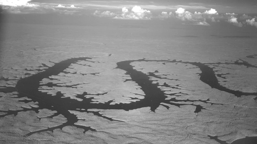
Lake of the Ozarks is a reservoir in south-central Missouri. Its blue outline looks less like a single open basin than a river with dozens of branches. The dam raised the water; the bends and side valleys that give the lake its shape were already there.
Lake of the Ozarks follows a flooded river valley
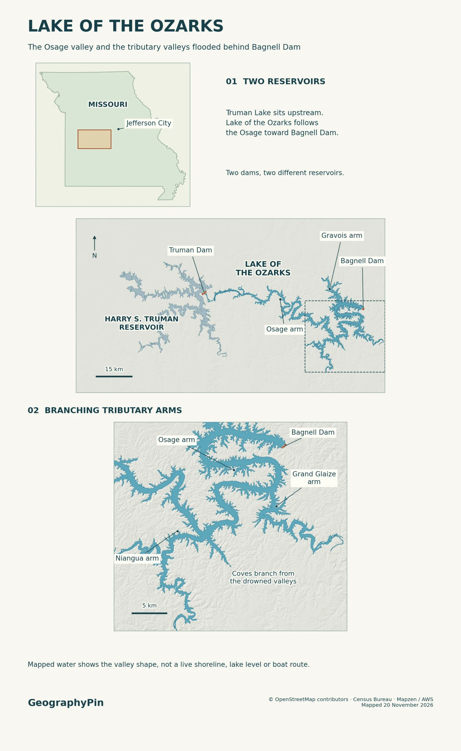
Lake of the Ozarks lies southwest of Jefferson City, Missouri. Bagnell Dam, completed in 1931, backed up the Osage River, flooding part of its winding valley and the lower reaches of tributaries.
On a map, the Osage Arm forms the main stem, with the Niangua, Gravois and Grand Glaize arms branching off.
How to use this article: Read the two-scale lake map, distinguish the two dams on the Osage, or compare surface area and shore length.
Where Lake of the Ozarks sits in Missouri
Find the long main stem before tracing the smaller coves
Look about 45 miles (72 km) southwest of Jefferson City, the approximate location used by Missouri’s Department of Natural Resources. The reservoir arcs through parts of Benton, Camden, Miller and Morgan counties. On the detailed map, start at Bagnell Dam near the northeastern end, then follow the longer waterway inland toward Warsaw. The narrow offshoots are not detached lakes.
Lake Ozark, without “of the” or a plural, is a city by Bagnell Dam. Lake of the Ozarks is the reservoir around multiple communities. Osage Beach is another city along its shores, not a single beach or a second name for the whole lake.
How Bagnell Dam made the lake
Union Electric built Bagnell Dam across the Osage River between 1929 and 1931 to produce hydroelectric power. Water began to build up behind it in 1931. It rose over low reaches of the river and its tributaries, leaving higher ridges and steep slopes along the newly formed shore. Ameren Missouri operates the dam today.
Below Bagnell Dam, water continues into the lower Osage River. The broad water on one side of the dam and the narrower river on the other are two parts of the same drainage system. The reservoir did not create the drainage divides, and the mapped water edge is not the watershed boundary.
Rising water also displaced communities. Missouri State Archives records the flooding of Old Linn Creek, which had been the Camden County seat. Residents moved, including to Camdenton or to the new Linn Creek. The modern town’s map label is not the position of the former settlement.
The Osage Arm between two dams
Follow the Osage upstream from Bagnell toward Truman Dam
The Osage Arm follows the old main valley. Missouri’s geologists describe rivers in the Ozarks that cut deeply into the landscape while keeping their winding courses. At the lake, the dam raised water over those bends rather than straightening them. A peninsula that projects into the lake can be the high ground inside one old river bend.
The Federal Energy Regulatory Commission describes an approximately 93-mile (150-km) reservoir, distinct from the much longer shoreline that runs around both sides and into the arms. Harry S. Truman Dam, upstream near Warsaw, holds back a different reservoir with its own water level. On the map, Truman Lake sits on the upstream side of that dam; water released from it enters the Osage corridor feeding Lake of the Ozarks.
If you compare maps, distinguish a curved route through the reservoir from a straight line between dams. A line drawn across a bend may cross an entire ridge on land. Neither line gives the shoreline distance or tells you how to navigate safely.
Why tributary coves add so much shoreline
Similar water area does not mean similar shoreline
The main stem receives the drowned lower reaches of the Niangua River, Gravois Creek and Grand Glaize Creek. Each broad arm contains smaller coves along its margins. A narrow inlet can extend well into the hills, adding two long banks but little water area.
| Reservoir | Published surface area | Published shoreline |
|---|---|---|
| Lake of the Ozarks | About 55,342 acres (224 km²) at normal pool in a 2011 FERC order. | About 1,150 miles (1,850 km), FERC. |
| Harry S. Truman Lake | About 55,600 acres (225 km²) at normal multipurpose pool, U.S. Army Corps of Engineers. | About 950 miles (1,530 km) in the Corps’ 1988 master plan. |
These are published figures, not measurements made from the same shoreline data. A higher or lower water level changes the edge, and a detailed map can follow bends that a small-scale map skips. The figures show why a lake’s area does not tell you how much shoreline to expect, not how much of the difference comes from its shape alone.
A simple comparison isolates the shape effect: a one-mile square covers one square mile and has four miles of edge. A rectangle four miles long and a quarter-mile wide covers the same area but has 8.5 miles of edge. A branching reservoir adds bends and coves rather than keeping its sides straight.
Reading the lake’s shore and place names
When a map label names an arm, it usually identifies a wide branch of the reservoir. A cove is a smaller inlet along that branch or the main stem. The same creek’s name can appear both on the arm and on the flowing water upstream of the reservoir. Missouri’s watershed references also use Grandglaize Creek as one word; the park uses Grand Glaize on its beach and marina labels.
A public site is a separate thing from a geographic label. The Grand Glaize Beach area of Lake of the Ozarks State Park is approached from U.S. 54 west of the Grand Glaize bridge, while Public Beach 1 has a different approach from Missouri 134. For a real visit, use the state park map and alerts instead of reading every shore on the atlas as public access.
Frequently Asked Questions
What older names might appear in records about Lake of the Ozarks?
The City of Lake Ozark’s history lists Osage Reservoir and Lake Osage as names used during construction, and Lake Benton as a name adopted by the Missouri General Assembly. They did not displace the name Lake of the Ozarks in common use. In current documents, LOZ is also used as shorthand.
Do lake mile markers start at the mouth of the Osage River?
No. FERC says marker zero on the lake is at Bagnell Dam, with main-channel numbers increasing upstream toward Truman Dam. Osage River miles start at the river mouth and use a separate system. On a lake listing, look for the named arm as well as the mile number.
Is a “headwater” reading at Bagnell Dam taken downstream?
No. Bagnell Dam headwater readings refer to the upstream, reservoir side; tailwater readings refer to the river below the dam. Ameren publishes the two separately. Neither number is the depth at a particular dock or cove.
What Did We Learn Today?
Bagnell Dam raised water into the main Osage valley and its tributary valleys. The resulting arms and coves explain why so much shoreline fits around the reservoir. Truman Lake lies upstream behind a different dam, and a length measured along the waterway is not the same as a length measured around its edge.
Sources & Data Notes
The Missouri watershed summary, FERC project license and USGS Bagnell monitoring location establish the Osage reservoir. The FERC normal-pool figures, Corps of Engineers’ Truman Lake description and Truman master plan provide separately published area and shoreline values; metric values are rounded. The Missouri Geological Survey on valley shape, Missouri State Archives on the dam and Linn Creek and City of Lake Ozark’s history explain the valley and its history. Use FERC mile-marker notes, Ameren’s dam-gauge reports, state park access points and Ameren shoreline management for mile-marker, water-level and access context. The atlas is not a navigation chart. October 1945 aerial photograph: Gerald Massie, courtesy of the Missouri State Archives, item CID_057_358, public domain; cropped and converted to WebP. Editorial responsibility: Zurab Koniashvili (Z.K. Atlas); AI tools assisted in preparation.
Map: GeographyPin; reference geometry from OpenStreetMap contributors (ODbL) and relief from Mapzen/AWS. The mapped shore is not a current lake-level reading or a property line.