Hunting Island is a South Carolina barrier island known for its state park, forest and lighthouse. Its beaches are not fixed edges: the lighthouse was moved because of erosion, and storms later opened a breach near the island’s southern end.
Hunting Island is a changing barrier, not a fixed outline
Hunting Island lies on the Atlantic coast of Beaufort County, South Carolina, between the Harbor Island area and Fripp Island. Its beach, maritime forest, lagoon and tidal marsh form a changing coastal landscape. The lighthouse’s 1889 relocation and the southern breach documented in 2016–2017 show different consequences of that change.
How to use this article: Distinguish the neighboring islands, understand the lighthouse move and compare different kinds of map lines.
Hunting Island on the South Carolina coast
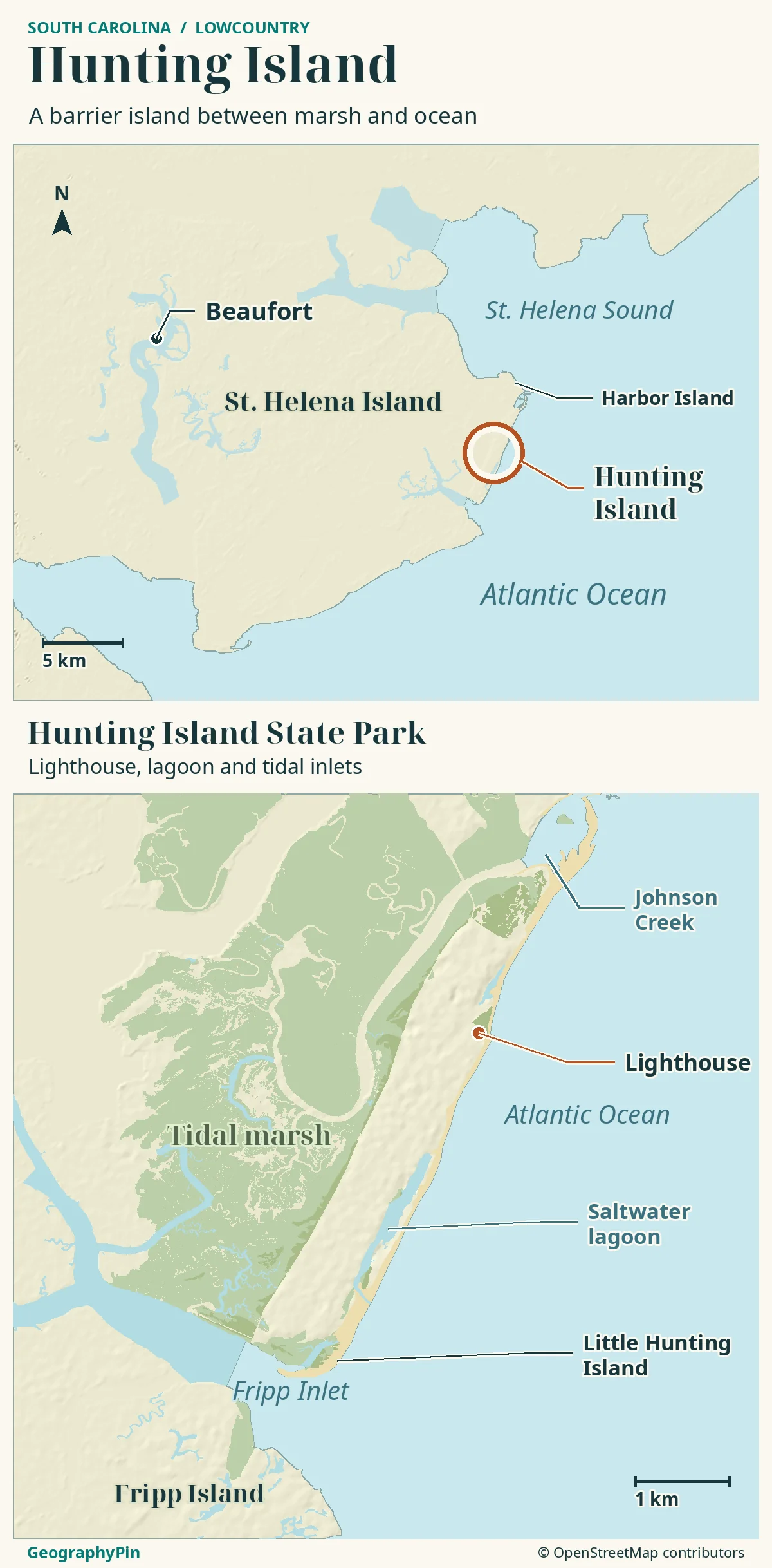
Hunting Island is a barrier island in Beaufort County, South Carolina, with the Atlantic Ocean on its seaward side and a landscape of beaches, forest, lagoon and tidal marsh. Hunting Island State Park is the visitor destination associated with the island; it is not another name for the neighboring Fripp Island community.
On a regional map, find Beaufort first, then follow the coastal road corridor toward Hunting Island. The park’s official directions use U.S. Highway 21. Harbor Island and Johnson Creek Inlet lie toward Hunting Island’s northeastern end; Fripp Inlet and Fripp Island are to the southwest.
Fripp Island is across the inlet
Fripp Island is a separate island, not the southern beach of Hunting Island. Fripp Inlet is the waterway between them. A road connection between neighboring islands does not make them one landform or give them the same visitor-access arrangements.
The regional map locates Beaufort and the surrounding islands; the close-up shows Hunting Island’s lighthouse, ocean beach, lagoon and marsh. These contrasting settings occupy different parts of the same barrier island.
Why a barrier beach changes shape
When storm waves overtop dunes, they can carry sand across the barrier. That process, called overwash, can reshape the beach without cutting a lasting channel. At Hunting Island’s south end, Hurricane Matthew washed across the beach in October 2016; the breach became permanent after Hurricane Irma in September 2017. The opening separated the southernmost beach from the rest of the island.
A single photo’s waterline does not show a long-term erosion rate. To measure change, compare the same shoreline feature on known dates.
The lighthouse move and the southern breach
The lighthouse makes coastal change visible on a human timescale. The present cast-iron tower dates from 1875. Its sectional construction allowed it to be dismantled and relocated when erosion threatened the site, and the move took place in 1889 (South Carolina State Parks).
Moving a tower is not the same as measuring retreat
The distance a building is moved is a preservation decision, not a measurement of how far the entire beach has retreated. It cannot be divided by the tower’s age to calculate an island-wide erosion rate.
That new opening near Fripp Inlet is a different kind of evidence from the 1889 lighthouse relocation: it records a new connection across the barrier, not a decision about where to move a building.
| Record | What it establishes | What it does not establish |
|---|---|---|
| Lighthouse relocation, 1889 | Erosion threatened a fixed structure and prompted relocation. | A uniform annual retreat rate for the whole island. |
| Southern breach, 2016–2017 | A documented storm-related change in the continuity of the southern beachfront. | The exact width or shape of that opening on a future visit. |
The park now uses the name Little Hunting Island for the southern visitor area reached by a pedestrian bridge. Treat the bridge and beach as places whose access needs checking, not as a permanently continuous beach walk.
Tidal marsh, maritime forest and a lagoon with a history
The ocean beach is only one part of Hunting Island. Inland are maritime forest and wetland habitats, with tidal creeks and salt marsh toward the more sheltered side. The contrast explains why an oceanfront photograph and a marsh-boardwalk photograph can show very different landscapes on the same island.
South Carolina State Parks describes the forest as vegetation established on old sand dunes, including slash pine, cabbage palmetto and live oak. This is not simply an inland lawn behind the beach: the wooded terrain is part of the barrier’s older sandy landscape.
The lagoon also has a human history. The park dates its creation to sand dredging in 1968. Its present wildlife habitat should therefore not be used as evidence that every water feature on the island formed without intervention.
The official trail descriptions distinguish the Lagoon Trail, interior Maritime Forest Trail and Marsh Boardwalk Trail. Those settings offer different ways to understand the island: water beside the lagoon, wooded upland and the salt-marsh edge. Their names are orientation aids, not assurances that every trail segment is open on a particular day.
A shoreline is not a park boundary or a permitting line
Read the date and the kind of line
A coastline on a road map, a water edge in an aerial photograph and a regulatory line answer different questions. The first helps orient you; the second records conditions when the image was taken; the third applies an administrative framework.
The South Carolina Department of Environmental Services maintains beachfront baseline and setback lines. Its public viewer states that the final Phase I lines, including Hunting Island, took effect on July 24, 2026. These are not tracings of the water’s edge and should not be presented as a historical shoreline comparison.
The same viewer warns that changing aerial imagery can make an overlay appear to shift. Its displayed lines are approximate reference information; exact property-specific positions require the published coordinates and a survey.
For ordinary geographic reading, the rule is simpler: keep the physical shore, mapped habitat and administrative boundary separate. An old road map can still help locate Beaufort while failing to show a newer opening in a beach.
Likewise, a park acreage is not a promise about the area of dry sand above a particular tide. The park lists approximately 5,000 acres (about 2,020 hectares) including beach, marsh and maritime forest. That mixed landscape should not be treated as one fixed dry-land island polygon.
Check access to Little Hunting Island and the lighthouse
As of November 19, 2026, the park’s official advisory said the bridge to Little Hunting Island/Boneyard Beach was temporarily closed because of hazardous conditions associated with recent and forecast high tides. It gave no reopening date.
Check the current park advisory before making that area the purpose of your visit. A trail description showing the bridge does not override a closure notice. Do not try to replace a closed crossing with an improvised beach or water route.
The lighthouse has a separate operating history: State Parks announced its reopening in May 2026 after a restoration closure that began in 2022. That dated reopening is not a guarantee of climbing access on every future day; use the official lighthouse page for present requirements.
Give shorebirds space and respect posted habitat areas. A coastal atlas helps you understand where you are; signs and current park instructions determine where you may go.
Frequently Asked Questions
Is Hunting Island the same as Huntington Beach State Park?
No. Hunting Island is in the Beaufort area. Huntington Beach State Park is a different South Carolina park near Murrells Inlet, associated with Atalaya and the Grand Strand. Check the complete park name when choosing directions or accommodation.
Why is Little Hunting Island separated from the main beach?
Two storms changed the island’s southern end. Matthew washed over it in October 2016, and the opening persisted after Irma in September 2017. For the pedestrian bridge, check the park’s current advisory.
What Did We Learn Today?
Hunting Island is a distinct barrier island near Beaufort, not Fripp Island or Huntington Beach. Its lighthouse, southern breach, forest and dredged lagoon reveal different parts of its changing coastal history. Read maps by date and purpose, and use current park notices rather than a mapped trail to judge access.
Sources & Data Notes
South Carolina State Parks supplies geography, habitat, lighthouse and access information. SCDES’s October 2025 report documents the 2016–2017 breach; its current viewer establishes the separate 2026 regulatory-line date. USGS and NPS explain barrier processes, not a Hunting Island erosion forecast. The park acreage conversion is rounded. Access was checked November 19, 2026 and may change.
- State Parks: park geography, acreage and current advisory
- State Parks: Beaufort County and road approach
- State Parks: maritime forest, marsh, lagoon history and habitat
- State Parks: named trails and Little Hunting Island
- State Parks: lighthouse construction and relocation
- State Parks: May 2026 lighthouse reopening
- SCDES: October 2025 technical report, including the southern breach chronology
- SCDES: current beachfront jurisdictional lines and mapping limitations
- USGS: sediment movement and storm-driven barrier change
- NPS: overwash, dune response and barrier limitations
- State Parks: Hunting Island and Huntington Beach locations
Map: GeographyPin original atlas using OpenStreetMap coastlines from the November 18, 2026 snapshot, with mapped lighthouse, lagoon, wetlands and woods retrieved November 19. © OpenStreetMap contributors, ODbL. These are data-retrieval dates, not shoreline survey dates: the atlas does not depict historical erosion lines or guarantee the present width of a breach. Relief: Mapzen/AWS Terrain Tiles and its underlying elevation sources. The park map was consulted for feature names, not traced. No trail to Little Hunting Island or legal boundary is drawn.
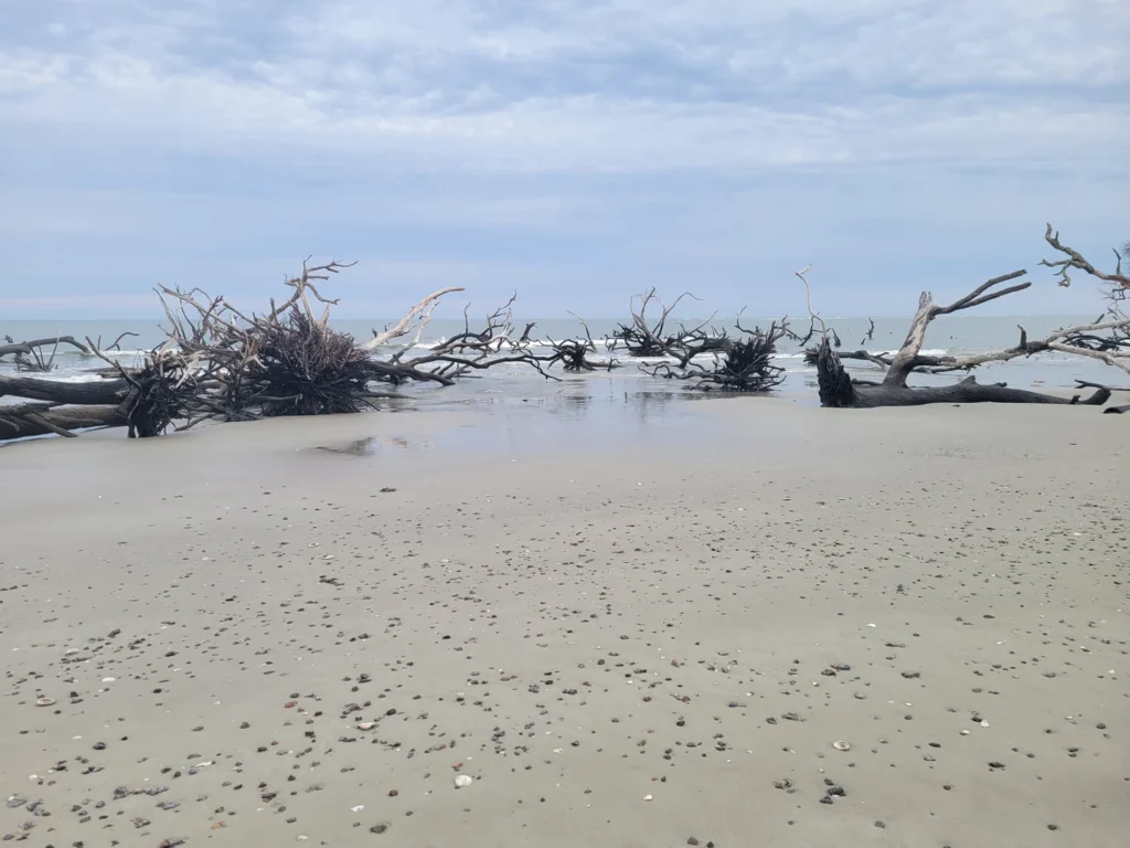
Photograph: Hunting Island Beach, CurlingMan13 / Wikimedia Commons, April 17, 2024, CC BY-SA 4.0. Resized and converted to WebP. The photo documents that landscape view, not present-day access.