Augusta is a Savannah River city whose history reaches well beyond golf. Its trading-town origins, canal mills, Black civic institutions and medical schools help explain a modern community with regional healthcare, education and cyber-training connections.
A river city with an industrial and civic legacy
Augusta is a city in east-central Georgia, United States, on the Savannah River at the South Carolina border. Its setting spans the Fall Line between the Piedmont and Coastal Plain. Augusta and Richmond County consolidated their governments in 1996; the Census balance area excludes Blythe and Hephzibah.
Find your starting point: Understand the river setting, distinguish the city’s statistical extent, or explore medicine and cyber work.
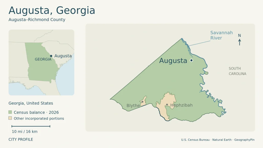
The map’s green area is the Census balance; tan marks Blythe and Hephzibah within the full consolidated area. The point locates Augusta generally, not its whole urban footprint. Enlarge map
1. Where Augusta sits on the Savannah River
A city at the Fall Line
Augusta lies in east-central Georgia, beside the Savannah River and the South Carolina state line. Its setting brings together the Piedmont uplands, the Sand Hills and the Coastal Plain. The Fall Line marks the transition between the Piedmont and Coastal Plain, making water and changing terrain central to the city’s geography.
The landscape is more varied than a flat riverfront might suggest. Richmond County’s northern and western areas include ridges and hillsides, while the Savannah River and its tributaries have lower floodplains. The river system drains much of the county, connecting urban neighborhoods with wetlands and woodland beyond the older center.
Augusta developed outward from the Savannah River, chiefly toward the south and west. Its riverfront commercial core, former industrial corridors and later neighborhoods belong to different phases of that growth. Summerville, once a separate community associated with seasonal homes and resort hotels, became part of Augusta in 1911.
2. Augusta, Richmond County and the balance area
What the population figures cover
The City of Augusta and Richmond County merged their governments in 1996 after a 1995 referendum. The consolidated government is led by a mayor and ten commissioners. Blythe and Hephzibah remained separate municipalities, so the county, the consolidated-city balance and the historic city are not interchangeable areas.
The Census Bureau calls the area outside those separate municipalities Augusta–Richmond County consolidated government (balance). This profile uses that geography for population and land area. It covers much more than the older downtown city, but it does not include all of Richmond County.
The Census Bureau’s Vintage 2025 estimate puts the balance population at 201,999 on July 1, 2025. The April 1, 2020 census counted 202,081 residents. These are local figures, not totals for the wider Augusta region, which extends into surrounding Georgia and South Carolina communities.
A map of this administrative area will include places that do not look like a continuous downtown. Its boundary identifies a government and statistical extent, not the outer edge of buildings. That distinction matters when comparing Augusta with cities whose municipal boundaries surround a much smaller historic core.
3. From trading town to canal industry
The colonial town dates to 1736, when James Oglethorpe had surveyor Noble Jones lay out its first forty lots. The site already belonged to a landscape of Indigenous communities and trade: the county’s historical account identifies Creek inhabitants and an established fur trade across the river at Fort Moore.
Named for Princess Augusta, the town developed as a trading center for commodities including tobacco and cotton. River transport connected the inland settlement with markets beyond the region. Augusta also briefly held a political role that is easy to overlook today: it served as Georgia’s capital from 1785 to 1795.
The Augusta Canal, built in 1845, supplied water, transportation and power for industry. Factories soon lined it. During the Civil War, the canal helped support Confederate manufacturing, including the Powder Works that produced ammunition. Later expansion brought large textile mills and associated workers’ communities.
The mills’ history was also a history of labor. The Canal Authority describes factory work performed largely by women and children, the growth of mill villages, and unrest over difficult working and living conditions. Industrial buildings are therefore evidence of workers’ lives as well as engineering ambition.
As textile production declined, the canal acquired a stronger recreational and heritage role. It remains functional infrastructure, not simply a preserved ditch: the National Park Service identifies continuing hydroelectric generation and a municipal water supply drawn from it.
4. Black civic institutions and civil rights
Augusta’s Black churches were important institutions for education, community organization and political action. Tabernacle Baptist Church, organized in 1885, illustrates how those roles developed over generations rather than beginning only with the best-known years of the civil rights movement.
Its founding pastor, Charles T. Walker, helped bring the Walker Baptist Institute to Augusta in 1891. The institution provided secondary education and teacher training for African Americans. That work connected religious leadership with opportunities denied or restricted elsewhere under segregation.
In the 1960s, under Charles Spencer Hamilton, Tabernacle helped organize students from Paine College who participated in sit-ins. The church also hosted Martin Luther King Jr., mass rallies and meetings devoted to nonviolent strategy. The National Park Service recognizes it within the African American Civil Rights Network.
This history makes the city’s institutions easier to understand. A church could be a place of worship, an educational partner and a meeting place for people challenging segregation. Augusta’s civic landscape was shaped by those overlapping uses, not only by government offices and commercial development.
5. Medicine, education and cyber work
Institutions with regional reach
Medical education has deep roots in Augusta. The Medical Academy of Georgia was chartered in 1828 and began classes the following year in the city hospital. It took the name Medical College of Georgia in 1833. The early connection between classrooms and hospital care helps explain the long relationship between education and healthcare in the city.
That institutional history includes exclusion and change. The college admitted its first woman student, Loree Florence, in 1921, and its first African American students, Frank Rumph and John Harper, in 1967. These dates show how access widened long after the school’s establishment.
A newer educational district is the Georgia Cyber Innovation & Training Center near the downtown riverfront. Augusta University’s School of Computer and Cyber Sciences is based there, alongside facilities for research, training and entrepreneurship. The university describes a setting designed to connect classes with employers and internships.
The military provides another major connection to technical work. Fort Gordon is home to the U.S. Army Cyber Center of Excellence, with a focus on signal and cyber training. The university and military institutions have different missions, but both help explain Augusta’s role in technical education and cybersecurity beyond the local market.
6. Music and golf in the city’s identity
James Brown grew up in Augusta during the Great Depression and World War II. His development from rhythm and blues into soul and funk gave the city an enduring connection to music heard around the world. The Augusta Museum of History preserves costumes, recordings, photographs and oral histories documenting that career.
Brown’s local legacy also included educational and philanthropic work. That connection adds a community dimension to a name often encountered chiefly through recordings and stage performances. He was not simply a famous person associated with a city; Augusta was part of the life behind his music.
Golf supplies another internationally recognizable association. Augusta National Golf Club opened in 1933, and its first tournament followed in 1934. The event later known as the Masters grew from a city that already had golf clubs connected with its resort history, including Augusta Country Club and Forest Hills.
Music and golf give Augusta a wide public profile, but neither alone explains the place. The river, industrial workforce, Black civic institutions, medical education and technical training all belong alongside them in the city’s story.
7. Dated Augusta facts
| Fact | Value |
|---|---|
| Location | East-central Georgia, on the Savannah River at the South Carolina boundary |
| Colonial town laid out | 1736 |
| Government consolidation | 1996, following the 1995 referendum |
| 2020 census count | 202,081 on April 1, 2020 |
| Population estimate | 201,999 on July 1, 2025; Vintage 2025 |
| Land area | 302.28 square miles (782.90 square kilometers), 2020 Census geography |
For a visit built around the riverfront, museums and separate canal outings, use the Augusta travel guide to compare routes, transport and places to stay.
What Did We Learn Today?
Augusta’s river setting supported trade and canal-powered industry, while churches and colleges shaped civic life and access to education. Medicine and cyber training broaden its modern role. The Masters and James Brown are important parts of its identity, but population and area describe the much wider consolidated-city balance, not just the historic center.
Sources & Data Notes
Open sources and data notes
Population and land area refer to Augusta–Richmond County consolidated government (balance), Census FIPS 1304204, excluding Blythe and Hephzibah. The 2025 estimate and 2020 census count are separate releases; land area is for 2020 and the metric conversion is rounded. Older comprehensive-plan chapters support physical geography and historical development only, not current population, employer rankings or operational advice. Fort Gordon’s current name and training role follow the Army’s own website.
Original GeographyPin locator using Census 2026 TIGER/Line consolidated-city, balance and water geometry, with Natural Earth populated-place and state context. Map boundaries use the 2026 release, not the 2020 land-area vintage.
- U.S. Census Bureau: Augusta–Richmond County consolidated government (balance), QuickFacts
- U.S. Census Bureau: consolidated-city balance definition
- Augusta government: consolidation presentation, April 2025, slide 8
- Augusta–Richmond County Comprehensive Plan: Natural Resources, pp. 179–181
- Augusta–Richmond County Comprehensive Plan: Cultural Resources, pp. 163–165
- Augusta Canal Authority: canal and mill history
- National Park Service: Augusta Canal National Heritage Area
- National Park Service: Tabernacle Baptist Church and civil rights
- Augusta University: Medical College of Georgia historical timeline
- Augusta University: School of Computer and Cyber Sciences facilities
- U.S. Army: Fort Gordon and its training role
- Augusta Museum of History: James Brown
- Augusta Museum of History: Celebrating a Grand Tradition