Macon’s name can mean the familiar downtown or the much larger consolidated Macon–Bibb County. Understanding that difference makes its map and population easier to read. The Ocmulgee River, Indigenous homelands, a planned trading town and locally rooted music all help explain the place beyond its statistics.
Macon’s river setting and city-county identity
Macon is a consolidated city-county in central Georgia, United States, on the Ocmulgee River at the Fall Line between the Piedmont and Coastal Plain. Its government is Macon–Bibb County. The city combines a nineteenth-century commercial core with Indigenous archaeological landscapes, music heritage, educational institutions and regional services.
Find your starting point: Explore the river landscape, clarify the city-county extent, or understand Macon’s institutions and work.
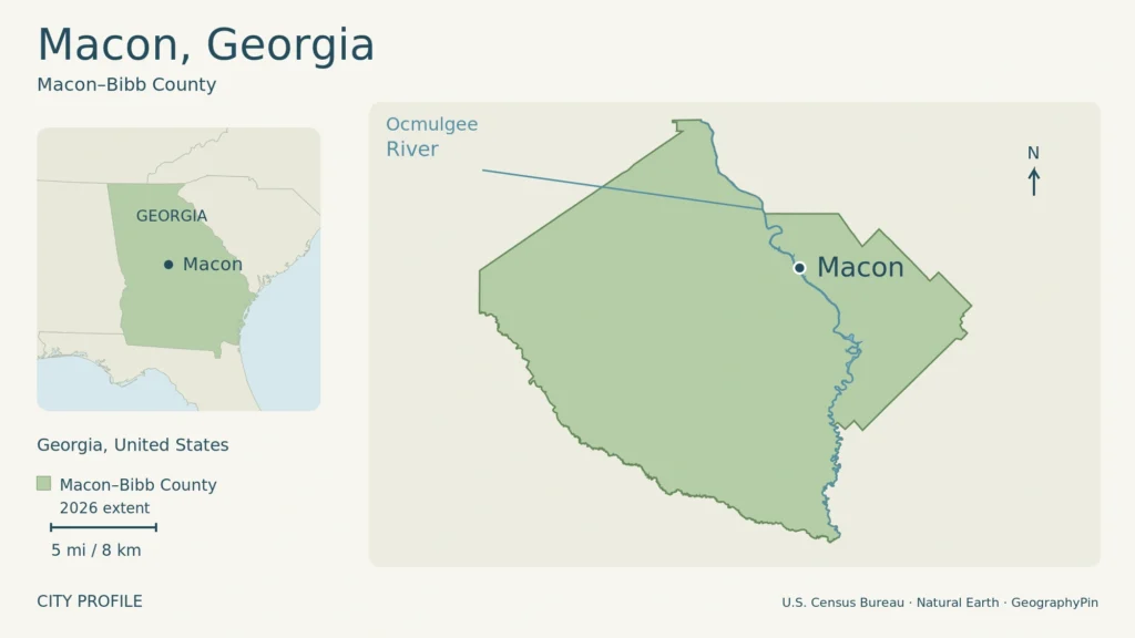
The map above shows Macon–Bibb County’s administrative extent and the Ocmulgee River, with a Georgia state locator. The shaded area is not the built-up city or metropolitan area. Enlarge map.
1. The Ocmulgee River and the Fall Line
Where two landscapes meet
Macon is in central Georgia, south of Atlanta, on the Ocmulgee River. It is an inland city rather than a coastal port. Its physical setting lies at the Fall Line, the transition between the rolling, rocky Piedmont and the lower Coastal Plain.
The river changes character around this meeting of landscapes. Upstream, it runs among hills, shoals and rocky stretches; downstream, it enters broad floodplains with wooded wetlands and oxbow lakes. The National Park Service describes the contrast particularly clearly at Ocmulgee Mounds, where upland woodland and low wet ground occur close together.
That combination helps explain why Macon’s river corridor is more than a strip beside downtown. It connects an urban setting with archaeological landscapes and floodplain habitats. Looking only at the street grid misses a defining part of the city’s geography.
2. What Macon–Bibb County includes
A consolidated government, not just downtown
Macon and Bibb County combined their governments on January 1, 2014, after voters approved consolidation in 2012. Macon–Bibb County therefore describes a much wider administrative area than the old city center. It contains the historic core, surrounding neighborhoods and less densely developed land within the county.
The small municipality of Payne City initially remained separate, but its separate status ended in 2015. Today’s Census place is named Macon-Bibb County, not “Macon-Bibb County balance.” The population and land figures below refer to that consolidated place. They are not a metropolitan-area total or a measurement of continuously built-up streets.
Pre-consolidation city figures cover a smaller area, so they cannot measure population growth within today’s boundary.
3. Indigenous homelands and the nineteenth-century town
Human settlement along the Ocmulgee long predates the city established in 1823. Around 900 CE, Mississippian communities developed a ceremonial complex and town on the Macon Plateau. Earthen mounds supported buildings, while other mounds served burial purposes. Farmers cultivated crops including corn and beans, alongside hunting and other food gathering.
These earthworks are evidence of a settled society, not natural hills. They form part of the landscape now protected at Ocmulgee Mounds National Historical Park. The National Park Service distinguishes the surviving ceremonial complex from the larger network of settlements that once occupied the area.
Muscogee history connects the river valley with communities whose homelands were progressively taken through settler expansion, contested treaties and forced removal. The Old Ocmulgee Fields Reserve was excluded from the 1805 land cession between the Oconee and Ocmulgee rivers. During the 1830s, forced removals carried Muscogee people west to Indian Territory, now Oklahoma. The Muscogee Nation continues today; this is not simply the story of a vanished people.
A planned center of trade
The 1823 town plan arranged Macon as a grid, with building lots, garden lots and land reserved around the settlement. Its river location allowed agricultural goods to move downstream and imported goods to reach the interior. Railways later strengthened the connection: the Monroe Railroad reached Macon in 1838, followed by the Central Railroad from Savannah in 1843.
Town growth also took place within a slaveholding economy. Mercer researchers and the Bibb County Superior Court Clerk’s Office have documented transactions involving the sale and lease of enslaved people in county deed books from 1823 to 1865. Those records put individuals and coerced labor back into a history too easily told only through buildings and commerce.
4. Music rooted in local places
Macon’s musical importance comes from people, stages and recording businesses, not from one genre alone. Otis Redding grew up here, although he was born in Dawson, Georgia. His early musical life included the Vineville Baptist Church choir and talent shows at the Douglass Theatre.
Those local settings help explain his connection to Macon without relocating his later recording career. His breakthrough recording of “These Arms of Mine” was made at Stax in Memphis in 1962. Macon was the formative community; Memphis was another crucial place in the music’s production.
Capricorn Sound Studios represents a different part of the city’s music geography. The studio opened in 1969 and became closely associated with the Southern rock recordings of the Allman Brothers Band, the Marshall Tucker Band and other artists. Musicians, recording rooms and a record business brought national activity into a downtown building.
Mercer’s restoration reopened the complex as Mercer Music at Capricorn in December 2019, combining recording facilities, rehearsal space and a museum. That reuse links music history with the continuing production of music, rather than treating the building only as a memorial to past performers.
5. An educational and employment center
Colleges, healthcare and industry
Mercer University moved from Penfield to Macon in 1871. Its arrival helped extend the city’s institutional landscape around Tattnall Square. The university’s history also records the later placement of its law school on Coleman Hill, giving Mercer a presence beyond one campus.
Education remains one part of a broader employment base. The Macon-Bibb County Industrial Authority identifies Mercer, Middle Georgia State University and the Bibb County School District alongside healthcare providers and businesses. Atrium Health Navicent and Piedmont Macon Medical Center illustrate the city’s role in providing medical services for Middle Georgia.
Insurance and manufacturing add other kinds of work. GEICO maintains a regional office in Macon, while YKK makes zippers and other fastening products there. These examples give a more concrete picture than describing Macon solely as a music destination or a college town.
Interstates 75 and 16 meet in Macon–Bibb County. The north–south and east–west connections support its central-Georgia role, and the industrial authority identifies warehousing, distribution and food processing among local industries. The modern road network continues the city’s long association with moving goods, although trucks and industrial sites now operate at a different scale from the early river town.
6. Dated facts and the shape of the city
The U.S. Census Bureau estimated 157,556 people in Macon-Bibb County on July 1, 2025. Its April 1, 2020 census count was 157,346. The figures are close, but an annual estimate and a census enumeration are different products, not two counts conducted in the same way.
| Fact | Value and date |
|---|---|
| Setting | Central Georgia, United States; Ocmulgee River and Fall Line |
| Town plan | 1823 |
| Government consolidation | January 1, 2014 |
| Census population | 157,346; April 1, 2020 |
| Population estimate | 157,556; July 1, 2025, Vintage 2025 |
| Land area | 249.38 square miles (645.89 square kilometers); 2020 geography |
Within that wider area, the historic commercial center retains the influence of its early plan. Attached commercial buildings, broad streets with planted medians, civic buildings and nearby residential districts describe a different urban texture from the river wetlands or outer industrial sites. The National Register documentation traces how these settings developed together.
For museum choices, music stops and a separately planned Ocmulgee outing, use the Macon travel guide to organize the visit around opening days and your group’s mobility.
What Did We Learn Today?
Macon makes sense as both a river landscape and a city built through several eras. Indigenous settlement preceded the planned trading town; slavery shaped its early economy, while music and education created lasting institutions. Today’s consolidated city-county is broader than downtown, so its population and map need that wider frame.
Sources & Data Notes
Open sources and data notes
Population and land area use Macon-Bibb County, Census place FIPS 1349008; the corresponding Bibb County totals were cross-checked. The 2025 estimate is not the 2020 census count. Land area uses 2020 geography, with a rounded metric conversion. The 2015 county report supports consolidation history only. National Register documentation supports historic urban development, not current building-by-building conditions. Business examples are not an employer ranking. Visitor access and tickets are outside this reference profile.
Original GeographyPin map using U.S. Census Bureau TIGER/Line 2026 place and water geography, checked against January 1, 2026 county boundaries, with Natural Earth 5.1.1/5.1.2 locator data. Map and statistical land-area vintages differ.
- U.S. Census Bureau: TIGER/Line map data
- Natural Earth: public-domain data
- U.S. Census Bureau: Macon-Bibb County QuickFacts
- U.S. Census Bureau: Bibb County QuickFacts, cross-check
- Macon-Bibb County: 2015 Analysis of Impediments, jurisdictional background, p. 8
- National Park Service: Natural Features & Ecosystems at Ocmulgee
- National Park Service: Mississippian Culture
- National Park Service: The Muscogee Nation
- National Register nomination: Macon Historic District (revised), description and significance
- Mercer University: research into Bibb County slavery records, October 2022
- Estate of Otis Redding: The Man
- Mercer University: Capricorn reopening, December 2019
- Mercer University: institutional history
- Macon-Bibb County Industrial Authority: major employers
- Macon-Bibb County Industrial Authority: location, highways and industries