Atlanta’s reputation reaches far beyond its city limits. Its role as Georgia’s capital, a transportation center and a place central to Black American history becomes clearer when the municipality is separated from the much larger metropolitan region around it.
Georgia’s capital and a regional crossroads
Atlanta is the capital of the U.S. state of Georgia, located in the northern Piedmont. The city extends across Fulton and DeKalb counties and grew from a railroad terminus. Its history includes Reconstruction, Black institution-building and civil rights activism; today it anchors a much larger metropolitan economy.
Find your starting point: Distinguish city from metro Atlanta, understand Sweet Auburn’s importance, or trace the changing urban landscape.
1. Where Atlanta sits in Georgia
Atlanta lies inland in the northern part of Georgia, the U.S. state, in the Piedmont. This is the rolling upland between the Appalachian mountains and the lower coastal plain. The city developed around a railroad junction rather than a seaport, and its transport connections still help explain its regional importance.
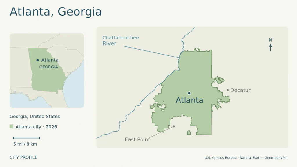
Green shading on the map marks Atlanta’s municipal territory, not the metropolitan area. City dots are representative points rather than downtown landmarks. Enlarge map.
The city is smaller than metro Atlanta
The municipal boundary crosses Fulton and DeKalb counties. Neither county is simply another name for Atlanta: each also includes places outside the city. The city’s GIS parcel service explicitly covers the parts of both counties inside Atlanta’s boundary.
Metro Atlanta extends much farther into surrounding communities. Its connected employment and housing markets give the city an influence far larger than its municipal population. A city map therefore answers a different question from a regional transport map: the first identifies the local-government area; the second helps explain how people and businesses connect across it.
The Census Bureau estimated 529,110 residents in Atlanta city on July 1, 2025, in its Vintage 2025 release. That figure is for the municipality, not everyone who describes their home as being in the Atlanta area.
2. From railroad terminus to state capital
Rail construction explains the location of the modern city, but not the beginning of human history here. Atlanta’s growth followed the dispossession and forced removal of Indigenous peoples from the region, including Muscogee and Cherokee communities. The nineteenth-century transport story belongs within that larger history.
Atlanta History Center dates the Western & Atlantic Railroad’s terminus at the future city site to 1837. The settlement became known as Terminus and then Marthasville before adopting Atlanta in 1845. These names trace a small rail settlement’s development into a city serving connections beyond a single line.
The surviving Zero Mile Post is a useful reminder of this origin. The History Center identifies it as an 1850s railroad marker, now preserved with the locomotive Texas. It should not be confused with the original 1837 survey stake. Railroads were both the reason for the settlement and an organizing force in its growth.
During the Civil War, Atlanta became a Confederate manufacturing and supply center. Union forces captured it in September 1864; destruction later that year devastated its railroad facilities and much of the built city. Reconstruction brought rebuilding and a new political role.
According to the Georgia Capitol Museum, Atlanta became Georgia’s capital in 1868, replacing Milledgeville. State lawmakers initially used other buildings before the present Capitol was completed in 1889. The capital’s move and the opening of today’s building are therefore separate dates.
3. Black Atlanta and the civil rights movement
Sweet Auburn was a living community
Auburn Avenue was not simply a backdrop for famous speeches. Black-owned businesses, churches and households made Sweet Auburn a center of community life under segregation. Martin Luther King Jr. was born and grew up here, within a neighborhood whose institutions showed both Black achievement and the constraints of racial discrimination.
The National Park Service’s account connects that setting with King’s life and the wider civil rights movement. The historic landscape includes his boyhood home and the original Ebenezer Baptist Church. Understanding the neighborhood means seeing the businesses and religious institutions together, rather than reducing its significance to one person’s biography.
Student organizing also shaped Atlanta’s struggle against segregation. The Capitol Museum records the Atlanta University Center students’ March 1960 appeal for equal rights and protests at government cafeterias. Six students who requested service at the Capitol cafeteria were arrested. This history places everyday public spaces, not only memorials, within the city’s civil rights story.
Higher education remains a major part of Black Atlanta. In southwest Atlanta, the Atlanta University Center Consortium brings together Clark Atlanta University, Morehouse College, Morehouse School of Medicine and Spelman College. They are separate institutions that collaborate through shared opportunities, including approved cross-registration. Their nearby campuses anchor an educational community with ties extending well beyond the city.
4. An economy built on connections
Atlanta’s transport role now reaches far beyond its original railroad junction. Hartsfield-Jackson Atlanta International Airport is owned by the City of Atlanta and operated through its Department of Aviation. Its domestic and international connections support passenger travel, freight, business activity and a large workforce across the region.
Airlines, contractors, concession businesses and government agencies work within the airport economy. Their overlapping activities connect Atlanta with employers and communities throughout the region.
Universities provide another kind of connection. Georgia Tech’s Midtown setting links teaching and research with businesses in Tech Square, while Science Square on the Westside focuses on health and technology. The university describes research labs, startups and corporate teams working around these districts. Atlanta’s knowledge economy has a physical geography: campuses and nearby workspaces bring institutions and employers into close contact.
Clark Atlanta University likewise describes opportunities across finance, media, healthcare, technology and the arts. Alongside state government and transportation, these institutions show why the city’s working life cannot be summarized as a single industry.
5. How redevelopment reshapes the city
Olympic sites and the Beltline
The 1996 Olympic and Paralympic Games left a lasting mark on Atlanta’s urban landscape. Centennial Olympic Park and new or adapted sporting venues changed the central city. Atlanta History Center also documents the costs: redevelopment around the Games affected established neighborhoods and public-housing residents, and replacement housing did not accommodate all former tenants.
The result is a history of both investment and displacement. A skyline or stadium photograph shows only part of that change; the experiences of residents explain why large projects can be celebrated and contested at the same time.
The Beltline represents another transformation of transport land. Its redevelopment program follows a historic 22-mile (35-kilometer) railroad corridor, combining trails, parks, housing initiatives and plans for transit. The corridor’s scale describes the program, not a promise that every planned component is already complete. It connects the city’s rail past to present debates about mobility, development and who can afford to remain nearby.
6. Atlanta city facts, with their dates
| Fact | Value |
|---|---|
| State role | Capital of Georgia since 1868 |
| Counties | Fulton and DeKalb |
| 2020 census population | 498,715, April 1, 2020 |
| Population estimate | 529,110, July 1, 2025; Vintage 2025 |
| Land area | 135.31 square miles (350.45 square kilometers), 2020 Census geography |
The table uses city figures throughout. The land area is a dated Census measurement, while the later population is an estimate. Neither describes the whole metropolitan region.
For sightseeing days, base-area choices and airport arrivals, use the Atlanta travel guide.
What Did We Learn Today?
Atlanta’s development joins transport, government and community history. Railways established its modern center; the capital, universities and airport broadened its reach. Sweet Auburn and student activism explain its civil rights significance, while Olympic redevelopment and the Beltline show how changing infrastructure also changes neighborhood life. The city boundary remains essential to understanding its population and size.
Sources & Data Notes
Open sources and data notes
Population figures refer to Atlanta city: the 2020 census count and the separate Census Vintage 2025 estimate. Land area is for 2020; the metric conversion is rounded. Beltline program scope is not a claim that all proposed transit and trail elements are complete. Institutional sources support their own activities; the New Georgia Encyclopedia supplies broader geographic and historical context.
Original GeographyPin map: U.S. Census Bureau TIGER/Line 2026 municipal and water geometry, with boundaries dated January 1, 2026; Natural Earth v5.1.1 public-domain state inset. It does not depict metro boundaries or travel routes.
- U.S. Census Bureau: Atlanta city QuickFacts
- City of Atlanta GIS: municipal tax-parcel coverage
- New Georgia Encyclopedia: Atlanta, by Andy Ambrose of Atlanta History Center
- Atlanta History Center: Locomotion, Railroads and the Making of Atlanta
- Georgia Capitol Museum: Welcome to the Georgia State Capitol
- National Park Service: Martin Luther King Jr. National Historical Park
- Clark Atlanta University: The Atlanta Advantage
- Georgia Tech: Campus Life and Atlanta research districts
- Hartsfield-Jackson Atlanta International Airport: About ATL
- Atlanta History Center: Venues and Impact, Planning the Sites of ’96
- Atlanta Beltline: About the redevelopment program