A journey across Russia passes through broad European plains, the Urals, wet Siberian lowlands, plateaus and Pacific mountain landscapes. Yet the country’s enormous outline tells only part of the story. Its rivers lead toward different seas, its climate changes across latitude and distance from the ocean, and its population is far more concentrated than its land area.
Russia spans eastern Europe and northern Asia, with Moscow in its European part. The Urals separate the broad European plain from the West Siberian Plain; farther east lie plateaus, mountain systems and the Pacific coast. European and southern settlement corridors contrast with the sparsely populated north. Large Arctic-draining rivers do not share the Volga’s Caspian destination.
How to use this article: Compare the main physical regions, follow the river systems, or explore why settlement is uneven.
1. Locate Russia and read its map
Russia occupies the northern part of the Eurasian landmass. Its Arctic coast faces north, while its eastern shores face the Pacific and its marginal seas. Moscow is well west of the Urals, not near the geographic center of the country. Kaliningrad is a separate Baltic exclave between Poland and Lithuania, disconnected from the rest of Russia by other countries.
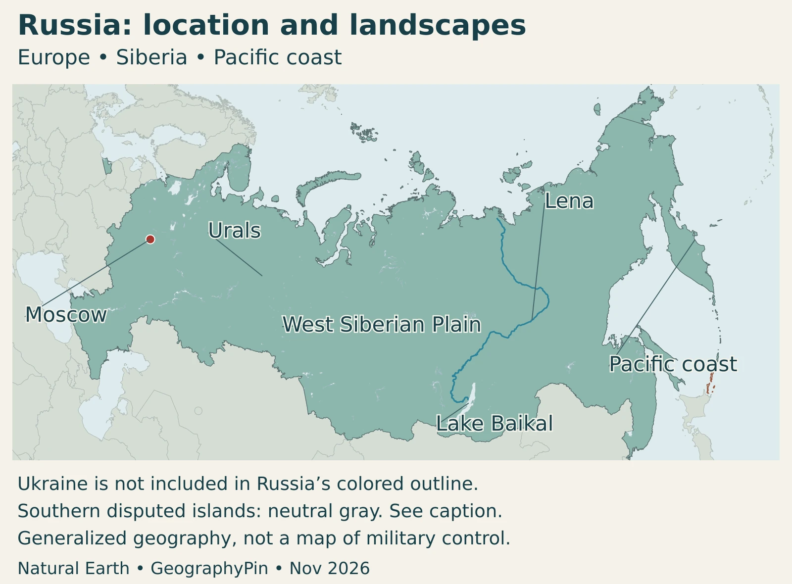
Europe and Asia are conventional geographic divisions of one connected landmass. The Urals are a widely used reference for their division in this part of Eurasia, but they are not a national border inside Russia. Siberia and the Russian Far East are regional terms; their geographic meanings should not automatically be replaced with the boundaries of similarly named federal districts.
Territorial scope: This profile distinguishes internationally recognized borders from claims and military control. Crimea and Sevastopol, and the Donetsk, Luhansk, Kherson and Zaporizhzhia regions, are Ukrainian territory. UN General Assembly resolutions reject Russia’s attempted changes to their status. The maps do not treat Russian annexation claims as internationally recognized additions to Russia, and they are not live battlefield maps.
In the Pacific, Russia administers the southern Kuril islands claimed by Japan as its Northern Territories. That separate sovereignty dispute is identified in the map notes rather than silently resolved by a fill color.
Russia’s scale is explored separately in our largest-country guide. Here, the emphasis is on the landscapes and connections within that outline.
2. Country facts with dates and scope
| Item | Fact and scope |
|---|---|
| Capital | Moscow |
| Population | About 143.4 million: UN World Population Prospects 2024 medium projection for 2026, not a census count |
| Reported surface area | About 6,601,670 square miles (17,098,246 km²), UNData’s figure dated 2023; separate from the generalized map footprint |
| Currency | Russian ruble (RUB) |
| State language | Russian nationwide; republics may establish additional state languages under the Constitution |
| Administrative structure | A federation of republics, territories, regions, federal cities and autonomous units; Russian official lists also contain annexation claims not recognized by the UN General Assembly |
Population projections and national statistical estimates are not interchangeable census counts. Territorial coverage also matters: a dataset may include areas that another source assigns differently. The figures above retain their own dates and definitions; no population density is calculated by combining them with the display map.
Similarly, the area of a country is not the area of its territorial sea or exclusive economic zone. An Arctic coastline, an inland lake and an offshore maritime claim are different kinds of geography, even when all appear in discussions of Russia’s size.
3. European Russia, Siberia and the Far East
A west-to-east framework
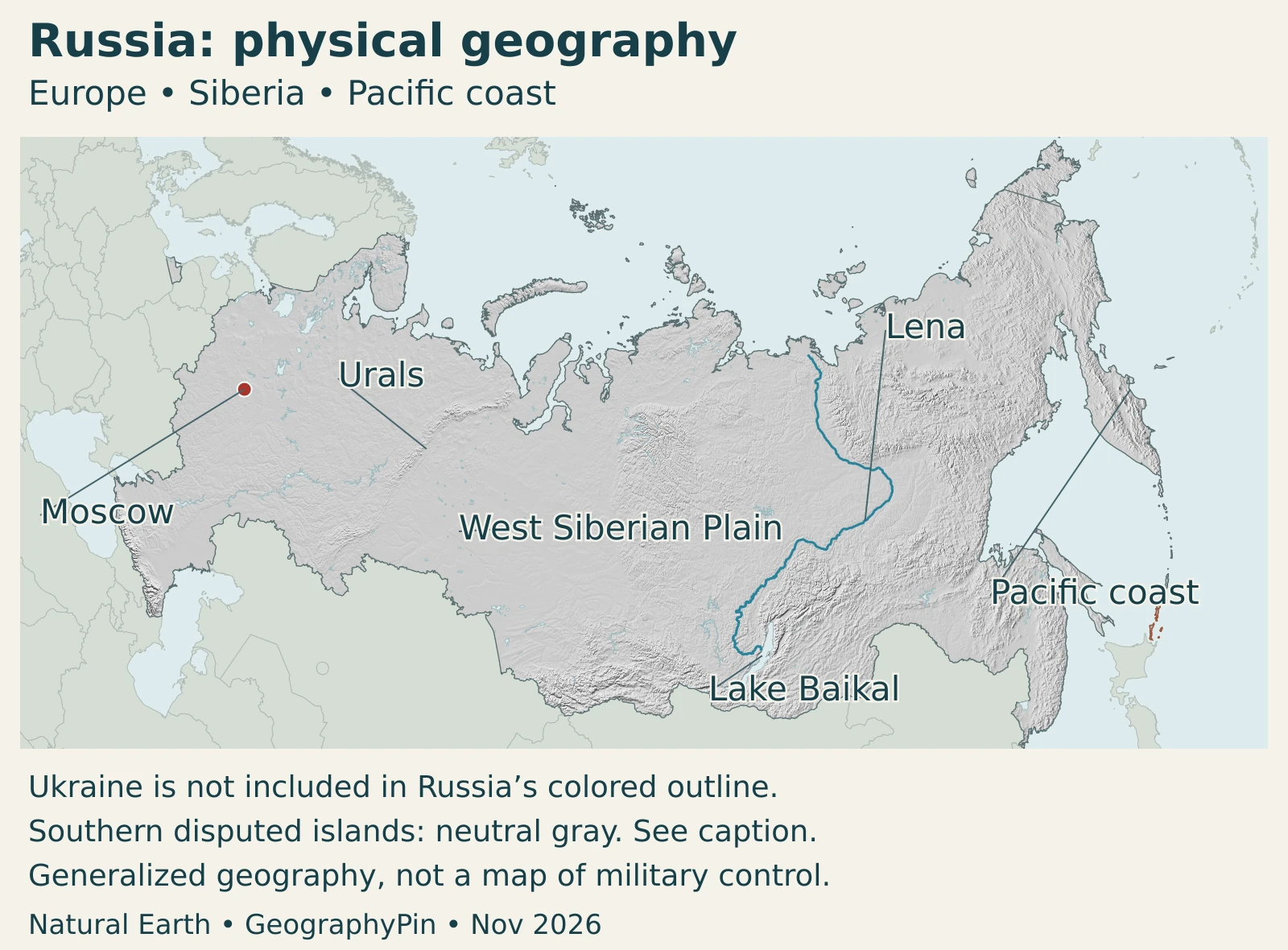
European Russia is largely a lowland and low-hill landscape. Crossing the Urals leads into another great lowland, the West Siberian Plain. The landscape does not stay flat across all of Asian Russia: the Central Siberian Plateau and eastern mountain systems introduce substantial relief.
| Setting | Terrain and position | Useful distinction |
|---|---|---|
| European Russia | Extensive plains and low hills west of the Urals | Contains Moscow and many longstanding settlement networks |
| Ural Mountains | North–south mountain belt between European and western Siberian lowlands | A geographic reference, not a separate country boundary |
| West Siberian Plain | Broad, low-relief terrain between the Urals and Yenisey | Flatness does not mean dry ground; wetlands and river networks are prominent |
| Central Siberian Plateau | Uplands cut by valleys east of the Yenisey | A plateau is not a perfectly level surface |
| Far Eastern mountains and coast | Mountain landscapes, coastal lowlands, peninsulas and islands toward the Pacific | Not simply a continuation of the western plain |
| Arctic margin | Northern coasts, islands and tundra environments crossing several regions | A climatic and coastal setting, not one uniform landform |
The West Siberian Plain is especially useful for understanding scale. It extends across contrasting vegetation zones, from northern tundra through forested environments toward southern grasslands. Low gradients encourage slow drainage in many places. Peatlands, ponds and winding channels make parts of this apparently simple surface hydrologically complex.
Farther east, satellite observations show rivers cutting into the Central Siberian Plateau, with hills, slopes and exposed rock layers. Local terrain can vary greatly even within one broad plateau label. Neither “Siberia” nor “plateau” means one uninterrupted, featureless surface.
Broad region labels on the map are locators. Their purpose is to connect recognizable terrain, not to draw exact edges around every forest, wetland or mountain province.
4. Climate, rivers and environmental contrasts
Cold does not mean one climate everywhere
Much of Russia has strong seasonal temperature contrasts associated with its continental setting. The interior is far from the moderating influence of oceans, while latitude and elevation add further differences. A Siberian winter, a summer in the southern steppe and conditions near the Black Sea are not interchangeable examples of “Russian weather.”
The Arctic margin has a much shorter warm season than southern regions. European Russia has greater Atlantic influence than the deep interior, while the southern Pacific side has a different seasonal moisture pattern. Countrywide averages hide these contrasts and should not be used to predict conditions in a particular city.
Permafrost is ground remaining at or below 32°F (0°C) for at least two years, not simply snow that lasts through winter. It occurs extensively in northern and eastern environments, but its distribution is uneven. Seasonal thaw near the surface and longer-term thaw can affect drainage and the stability of ground supporting roads and buildings; a terrain map alone cannot show those engineering conditions.
Three very different water settings
The Ob, Yenisey and Lena carry water northward toward Arctic seas through separate, enormous drainage basins. Their tributaries connect southern and interior landscapes with the Arctic coast. Snowmelt produces a strong seasonal flow pulse, and reservoirs affect some river systems; annual discharge is not evenly distributed across the calendar.
The Volga follows a different path. It flows toward the Caspian Sea, forming a large delta at its northern shore. The Caspian is an inland body of water, so the Volga does not empty directly into the Arctic Ocean simply because it is a major Russian river.
Lake Baikal in southeastern Siberia is another distinct setting: an ancient, exceptionally deep freshwater lake with many endemic species. Its ecological importance comes from its geological history and unusual freshwater communities, not just the size of its outline. Our Lake Baikal article examines the lake in detail.
A lake, a river basin and a physical region are not interchangeable boundaries. Baikal belongs within Siberia, but Siberia is not one lake catchment; the Arctic river basins and the Volga system demonstrate how different drainage directions coexist within one country.
5. People, cities and languages
Why population does not follow the size of the map
Russia’s population is concentrated much more strongly toward the west and south than its land area. Research examining regional patterns from 2002 to 2020 found a pronounced west–east and south–north imbalance, with important eastern concentrations along the Trans-Siberian transport corridor. This is a pattern of settlement, not a claim that Siberia is empty.
Established cities, transport connections, employment and the costs of living in harsh environments reinforce one another. A place with services and reliable links can attract people even when another region has far more land. Climate helps explain the pattern, but it is not the sole cause: historical investment and economic connections matter too.
Moscow and St. Petersburg anchor major western urban networks. Siberian and Far Eastern cities serve their own regional economies rather than merely filling gaps between them. Comparing these places requires consistent boundaries: a federal city, a surrounding administrative region and a metropolitan area are different statistical units.
Citizenship, language and region are different categories
Under Article 68 of Russia’s Constitution, Russian is the state language throughout the federation, while republics may establish their own state languages for use alongside it. That legal arrangement is different from saying every citizen has the same mother tongue. Citizenship, ethnicity and language are related aspects of identity, not interchangeable categories.
A broad label such as “Siberian” describes a geographic connection, not one ethnicity or mother tongue. Large regions contain distinct Indigenous communities, cities and rural economies. Neither sparse population on a map nor a low national density means that the land lacks communities or local histories.
6. Government and economy in their geographic setting
Russia’s constitutional structure is federal and republican. Its constituent units have several legal categories, including republics, regions and territories; these administrative divisions are not the same as physical Siberia, a river basin or the Urals. Official Russian lists include claimed Ukrainian territories, so an unqualified count would obscure the distinction between Russia’s domestic claims and internationally recognized borders.
Energy production illustrates the gap between where resources occur and where people live. The U.S. Energy Information Administration’s July 2025 assessment identifies Western Siberia as the principal crude-oil and condensate production region, while the Volga–Urals area is also important. The Kuznetsk Basin, or Kuzbass, is a major coal-producing area. These are regional production patterns, not a description of every local economy.
Moving resources requires connections across considerable distances. Pipelines, railways and ports link inland production with processing centers and markets. A resource-rich region can therefore have substantial economic output without having the population concentration of Moscow. Conversely, a large service and administrative center need not sit above a major oilfield.
These networks also change. The EIA’s 2025 assessment describes shifts in energy trade following Russia’s full-scale invasion of Ukraine and subsequent sanctions. That dated account should not be read as a promise that a particular route, project or trade arrangement remains unchanged. This profile emphasizes the underlying economic geography rather than live trade volumes.
The Russian Federation is not the Soviet Union, and a country’s constitutional label does not by itself explain how its political system operates. Our separate Russia political-system explainer addresses that narrower question.
Frequently Asked Questions
Is all of Russia in Asia?
No. Russia spans eastern Europe and northern Asia. Moscow is in the European part, west of the Urals. The Europe–Asia division is a geographic convention within Eurasia, not a national border dividing Russia into separate countries.
Why is Russia’s population concentrated toward the west and south?
Long-established urban networks, transport, employment and more favorable living conditions reinforce settlement in those areas. Climate is part of the explanation, but history and infrastructure also matter. Siberia and the Far East contain important cities and communities despite their much lower average population concentration.
Do Russia’s major rivers all flow to the Arctic Ocean?
No. The Ob, Yenisey and Lena drain toward Arctic seas, but the Volga flows into the inland Caspian Sea. A country boundary can contain several drainage systems with different destinations.
What Did We Learn Today?
Russia’s vast outline contains contrasting plains, plateaus, mountains and coasts. The Urals help orient European and Asian landscapes, while river destinations reveal a different set of connections. Population and economic activity are unevenly distributed, and neither climate nor resources alone explains that pattern. Dated statistical definitions and clear distinctions between recognized borders, territorial claims and actual control are essential when reading the country’s maps and facts.
Sources & Data Notes
- United Nations General Assembly, resolution 68/262: Ukraine’s territorial integrity and the status of Crimea and Sevastopol.
- United Nations General Assembly, resolution ES-11/4: Non-recognition of attempted annexation of four Ukrainian regions.
- Ministry of Foreign Affairs of Japan, Northern Territories: Japan’s stated claim concerning the islands administered by Russia.
- Library of Congress, Russia country profile: 2006 geographical background for broad physical regions; contemporary figures are dated separately.
- NASA Earth Observatory, West Siberian Plain: Low relief, vegetation transitions and drainage setting.
- NASA Earth Observatory, Central Siberian Plateau: Observed hills, valleys and terrain within the plateau.
- CMCC, G20 Climate Risk Atlas: Russia: Regional climatic contrasts; future scenarios are not presented as current observations.
- National Snow and Ice Data Center, permafrost: Temperature-based definition and distinction from seasonal freezing.
- Arctic Great Rivers Observatory, river basins: Separate Ob, Yenisey and Lena drainage basins and river monitoring context.
- NOAA Arctic Report Card, river discharge: Seasonal discharge and snowmelt context, not a current-year flow estimate.
- NASA, Volga River and Caspian Sea: Volga drainage destination and delta.
- UNESCO, Lake Baikal: Lake setting, antiquity and distinctive freshwater biodiversity.
- Chu and colleagues, spatial population and economic patterns: Research based on 2002–2020 regional data; no current population share inferred from historical results.
- U.S. Energy Information Administration, Russia country analysis: July 24, 2025 assessment of energy-producing regions and transport connections.
- UN World Population Prospects 2024, Russia projection: 2026 medium projection of 143,394,458, rounded in the facts table.
- UNData, Russian Federation country profile: Area dated 2023, capital and currency. Other rows in that profile can use different territorial coverage; they are not combined here.
- Ministry of Justice, Constitution of the Russian Federation: Federal structure, state-language provisions and Moscow’s capital status; domestic territorial listings are not treated as international recognition.
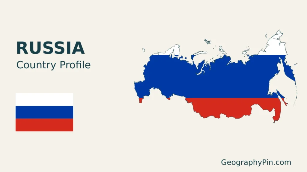
Map sources and scope: Original GeographyPin compositions use public-domain Natural Earth country, city, river and lake geometry and its actual shaded-relief raster. The Ukrainian-view country dataset keeps Ukraine, including Crimea, outside Russia’s highlighted outline. The 2014 and 2022 UN General Assembly resolutions explain the legal-status convention. No current front line or military-control boundary is drawn.
The maps use one Lambert azimuthal equal-area frame centered at 65°N, 100°E. Islands remain in their source positions, including across the 180° meridian; there are no relocated insets. The southern islands administered by Russia and claimed by Japan are neutral-styled rather than assigned national colors. This does not imply a lack of Russian administration. Generalized outlines can omit small coastal details, and regional labels identify broad settings rather than measured borders.
The Lena line and Lake Baikal outline follow source features; terrain shading depicts landform, not elevation classes. November 2026 is the artwork preparation date, not a new boundary survey. The cover uses the authentic proportions and colors of the Russian flag with a complete flag shown alongside the decorative outline. GeographyPin branding identifies the original composition.