A map of Spain is easy to misread if it shows only the peninsula or treats the entire interior as mountains. The useful starting point is the relationship between the elevated Meseta, its surrounding ranges, rivers flowing to two seas, and islands far beyond the mainland.
Spain is a southwestern European country occupying most of the Iberian Peninsula, with additional territory in the Mediterranean, Atlantic and North Africa. Its mainland geography centers on the Meseta plateau, surrounding mountain systems and rivers draining toward the Atlantic or Mediterranean. The Balearic and Canary islands add distinct geological and climatic settings.
How to use this article: Start with what the national outline includes, understand the Meseta, or follow the rivers to their coasts.
1. Where is Spain?
Spain occupies most of the Iberian Peninsula in southwestern Europe, but a mainland-only outline leaves out important parts of the country. The Balearic Islands lie in the Mediterranean, the Canary Islands in the Atlantic, and Ceuta and Melilla on the North African coast.
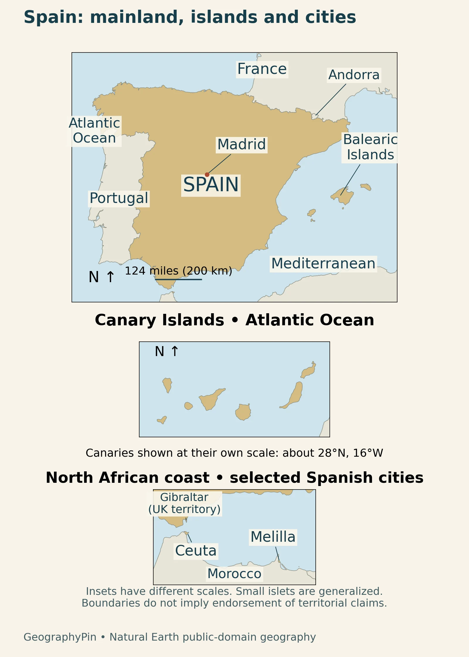
Mainland borders are not the whole national outline
On the peninsula, Spain borders Portugal, France and Andorra, and meets the British Overseas Territory of Gibraltar at its southern edge. Ceuta and Melilla have land borders with Morocco. Gibraltar is not part of Spain, while the two Spanish autonomous cities are not on the European mainland. A national population or area figure must therefore use a wider territorial scope than “mainland Spain.”
The IGN physical-geography overview places the archipelagos and North African cities alongside the peninsula when describing national territory. The map uses generalized outlines rather than a complete inventory of every small islet or a statement about disputed claims.
2. Country facts with dates and scope
The table combines stable national context with statistics that need a reference date. Population counts residents, not everyone worldwide holding Spanish nationality. Area includes territory beyond the mainland. Neither figure should be compared with a mainland-only map without checking the scope.
| Topic | Figure or description | Scope |
|---|---|---|
| Capital | Madrid | National capital |
| Area | About 195,361 sq mi (505,983 km²) | EU overview, 2026 geographical-size series |
| Population | 49,935,642 residents | October 1, 2026; provisional INE estimate |
| Currency | Euro (€) | National currency |
| Political system | Parliamentary monarchy | Constitutional form of government |
| Territorial administration | 17 autonomous communities and 2 autonomous cities | Administrative units, not physical regions |
| Highest point | Teide, about 12,188 ft (3,715 m) | Tenerife, Canary Islands; park authority figure |
The INE release of November 12, 2026 supplies the population estimate. INE revises its provisional series as newer census information becomes available, which is why an earlier release may give a different figure for the same date. Area and administrative context come from the EU country overview; the summit height comes from the Teide park authority.
3. The Meseta and the mountain systems
The Meseta is a plateau, not a mountain range
Much of mainland Spain is organized around the Meseta, an extensive elevated interior. It is not a uniformly flat surface: valleys, basins and mountain ranges break it into distinct landscapes. The Sistema Central separates its northern and southern parts, while the Montes de Toledo interrupt the southern plateau. The IGN description of the Meseta explains this structure rather than treating all high ground as one continuous mountain chain.

Mountains around and beyond the plateau
The Cantabrian Mountains border the plateau to the north, the Iberian System lies to the east, and Sierra Morena marks its southern edge. The Pyrenees and Betic ranges are exterior systems rather than simply additional names for the Meseta. The Ebro and Guadalquivir lowlands occupy different positions around these uplands.
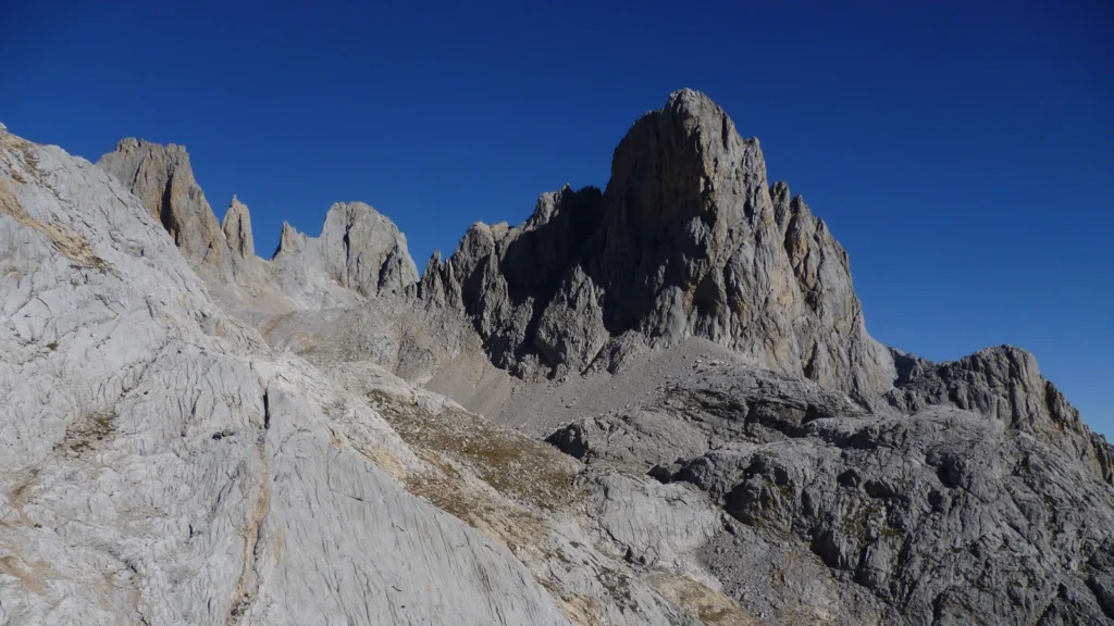
The IGN description of the mountain rim highlights an important asymmetry in the Cantabrian Mountains: slopes toward the northern coast are steeper than the gentler approach from the plateau. That contrast helps explain why a short trip on a map can cross a substantial elevation change. The featured photograph shows the Picos de Europa, a northern limestone mountain landscape, not a typical view of every Spanish region.
4. Rivers and their coastal destinations
Atlantic and Mediterranean drainage
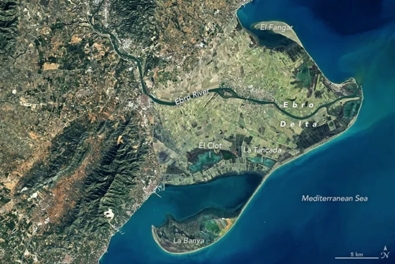
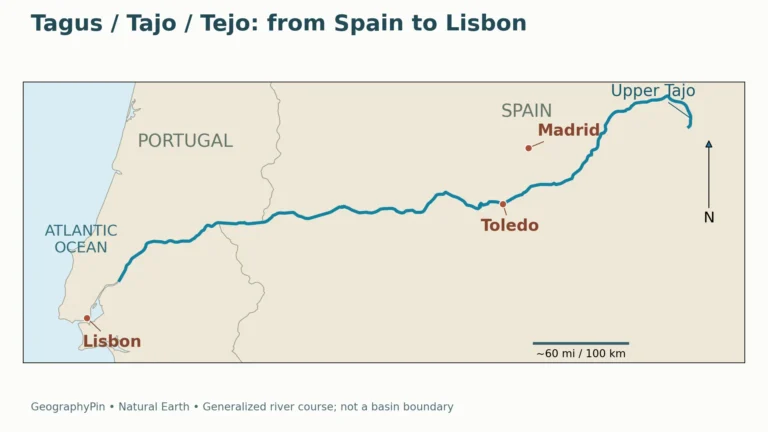
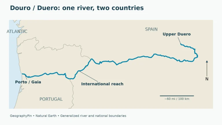
The Duero, Tajo, Guadiana and Guadalquivir drain toward the Atlantic. The Ebro flows toward the Mediterranean. The Duero and Tajo become the Douro and Tagus in Portugal, so a map that stops their courses at Spain’s border hides their downstream connections. A river name can change without the river becoming a different water system.
A river basin is the land contributing runoff to a shared outlet. MITECO’s basin definitions distinguish that hydrologic unit from its smaller subbasins. These divisions do not have to match autonomous-community borders. The relief image draws selected river courses, not precise drainage-basin boundaries or water-management jurisdictions.
Read the river lines together with the terrain. The Duero crosses the northern plateau, the Tajo drains much of the southern plateau, and the Ebro occupies a separate depression south of the Pyrenees. These courses connect interior basins with different coastal outlets.
5. Two archipelagos beyond the mainland
Balearic and Canary islands are different landscapes
The Balearics are Mediterranean islands with geological connections to the peninsula’s mountain systems. Mallorca’s Serra de Tramuntana occupies its northwest, while Menorca has a different structural relationship. The IGN island overview contrasts these landscapes with the volcanic Canary Islands in the Atlantic.
On Tenerife, Teide rises above the surrounding volcanic landscape. The Canary Islands park authority identifies it as Spain’s highest peak, about 12,188 feet (3,715 m) above sea level. This makes the distinction between “highest in Spain” and “highest on mainland Spain” essential: the national summit is not in the Pyrenees or on the Meseta.
Islands also contain working landscapes rather than only beaches and mountains. UNESCO’s description of Mallorca’s Serra de Tramuntana explains how agricultural terraces, dry-stone structures and interconnected waterworks adapted steep terrain to cultivation. That is a concrete example of people reshaping a Mediterranean mountain environment without removing its underlying relief.
6. Why climate changes across the country
Spain does not have one climate that can be applied equally to a northern mountain village, an interior plateau city and a Canary coastal settlement. Latitude, elevation, ocean exposure and mountain barriers interact. A climate classification describes patterns over many years, not the weather on a particular day.
AEMET’s 2022 climate-classification study, covering 1951–2020 maps mild-summer climates without a dry season in parts of Galicia, the Cantabrian region and the Pyrenees. Dry-summer Mediterranean types occur widely elsewhere, while dry steppe conditions appear in parts of the southeast and interior. The Canary Islands contain pronounced contrasts between coastal lowlands and higher ground.
These are broad patterns with local exceptions. “Northern Spain is wet” is a starting point, not a substitute for a location-specific climate record. Likewise, “Mediterranean” does not mean that mountains, inland basins and exposed coasts share identical temperatures or rainfall. The terrain map helps identify where elevation or shelter may matter, but it is not itself a rainfall map.
7. People, languages and regional boundaries
Physical regions and autonomous communities are different
The Meseta, Pyrenees and Ebro Basin describe landforms or drainage. An autonomous community is a unit of government. A physical region can cross several administrative areas, and an administrative area can contain contrasting landscapes. Confusing the two makes maps of languages, population or government powers difficult to interpret.
Under Article 3 of Spain’s Constitution, Castilian Spanish is the official language of the state. Other Spanish languages may also be official in their respective autonomous communities according to their statutes. That does not make every regional language official throughout the entire country. Language use, cultural identity and administrative boundaries are related subjects, but they are not interchangeable maps.
The Basque Country profile illustrates the distinction: the Spanish autonomous community is not identical to every use of the wider historical and cultural name. Madrid’s role is different again. It is the national capital, not a separate physical region that replaces the surrounding interior landscape.
8. Economy through regional connections
Geography shapes economic connections without determining every outcome. A high interior does not prevent links to the coast, and a Mediterranean location does not mean that every local economy depends on beach tourism. Ports, overland transport, farming and processing connect contrasting regions.
A Mediterranean port serving the interior
The Valencia Port Authority describes road and rail connections between its Mediterranean port system and Madrid and central Spain. This illustrates how the coast and the Meseta work together: a maritime gateway can serve production and consumption far inland. Port location is only part of the explanation; the inland transport network makes that location useful.
Agriculture provides another regional example. The Andalusian government’s February 2025 olive-sector strategy identifies olives as a major crop linked to rural employment, processing and exports. It also addresses water storage and irrigation efficiency. An olive-growing landscape therefore involves more than suitable terrain: water management, farming decisions and processing infrastructure help shape its economic role.
What Did We Learn Today?
Spain’s geography is organized around an elevated mainland interior, surrounding ranges and rivers with different coastal destinations. The Balearics and Canaries are geographically and geologically distinct, while Ceuta and Melilla extend the national outline to North Africa. A useful country profile keeps physical regions separate from administrative boundaries and attaches dates and territorial scope to national statistics.
Sources & Data Notes
Population is the provisional INE estimate for October 1, 2026, released November 12. Area follows the EU overview’s 2026 geographical-size series. Climate descriptions use AEMET’s 1951–2020 classification, not a short-term forecast. Teide’s elevation follows its park authority.
- INE: population as of October 1, 2026, provisional
- European Union: Spain country overview
- IGN: the main features of Spain’s relief
- IGN: the Meseta and its interior divisions
- INTEF: Spain’s Atlantic drainage
- IGN: mountain systems around the Meseta
- IGN: the relief of the Spanish islands
- MITECO: river basins and subbasins
- AEMET Technical Note 37: Köppen climate classification, 1951–2020
- Spanish Constitution: Articles 1, 3 and 5
- Government of the Canary Islands: Teide National Park
- Valencia Port Authority: maritime and land connections
- Andalusian government: olive-sector strategy, February 2025
- UNESCO: Cultural Landscape of the Serra de Tramuntana
Original cartography: GeographyPin, using Natural Earth public-domain geography. Locator insets have different scales; small islets are generalized. The relief image focuses on the mainland and five selected river courses, not exact basin boundaries or current water levels.
Elevation uses Mapzen Terrain Tiles, decoded from Terrarium data in Web Mercator, with source cells roughly 3,000 ft (900 m) wide near 40°N. Display resampling does not increase source precision. Credit: Mapzen; Europe data produced using Copernicus data and information funded by the European Union, EU-DEM layers; USGS SRTM/GMTED2010; NOAA ETOPO1. See the terrain attribution.
Featured photograph: Picos de Europa, October 2011, AnaisGoepner, CC BY-SA 4.0. Cropped to a wide frame and resized; the derivative retains the same license.