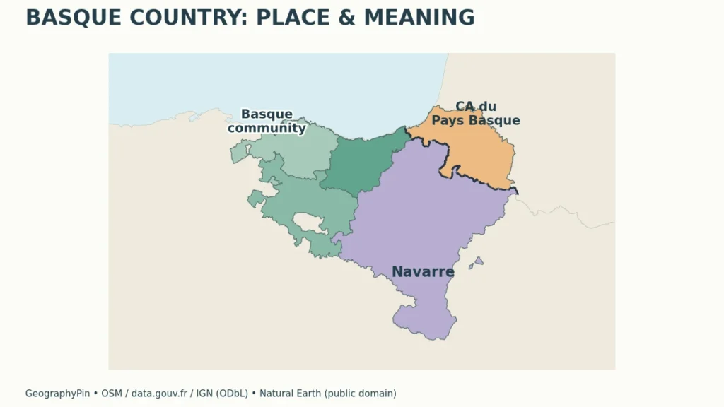
A map labeled “Basque Country” may show three territories, seven historical territories or a French intermunicipal area. The first task is not choosing which outline looks familiar, but understanding what each outline is intended to represent.
The Basque Country is not an independent sovereign state. In administrative usage, it often means Spain’s Basque Autonomous Community, comprising Araba/Álava, Bizkaia and Gipuzkoa. A wider historical and cultural meaning also includes Navarre and the French Basque territories, which remain under different present-day institutions in Spain and France.
How to use this article: Start with the territorial definitions, check Navarre’s separate status, or compare the seven historical territories.
1. Which Basque Country Does a Map Show?
Start with the territorial definition
The name Basque Country can refer to an autonomous community in northern Spain or to a wider historical and cultural region extending into southwestern France. Those meanings overlap, but they do not have identical boundaries or institutions. A map, statistic or travel description needs to say which meaning it uses.
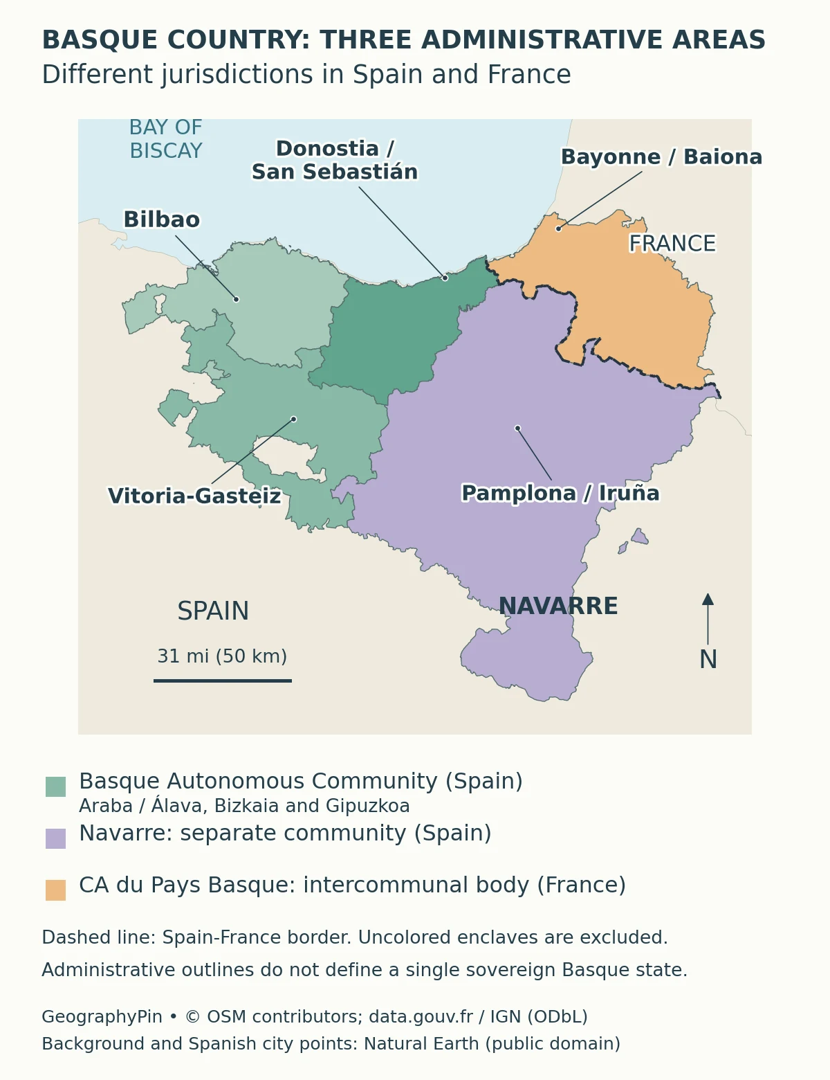
The present international boundary separates Spain and France. Within Spain, the Basque Autonomous Community and Navarre are separate autonomous communities. On the French side, the Communauté d’Agglomération Pays Basque is an intermunicipal body, not a Spanish-style autonomous community.
| Name or usage | What it describes | What it does not mean |
|---|---|---|
| Basque Autonomous Community / Euskadi | Three historical territories in Spain: Araba/Álava, Bizkaia and Gipuzkoa. | Not all seven historical territories and not a sovereign state. |
| Navarre / Navarra | A separate foral autonomous community in Spain. | Not presently part of the Basque Autonomous Community. |
| French Basque Country / Iparralde | A historical and cultural regional term on the French side. | Not the whole Pyrénées-Atlantiques department or an independent country. |
| Communauté d’Agglomération Pays Basque | A French intermunicipal institution grouping member communes. | Not equivalent in powers or status to a Spanish autonomous community. |
| Wider Basque Country / Euskal Herria | A historical and cultural framework commonly described through seven territories. | Not one current cross-border sovereign administration. |
2. The Basque Autonomous Community in Spain
Three territories, with institutions in Vitoria-Gasteiz
The Basque Autonomous Community comprises Araba/Álava, Bizkaia and Gipuzkoa. These are often called historical territories in the region’s institutional system. Their provincial centers are Vitoria-Gasteiz, Bilbao and Donostia-San Sebastián respectively.
The Statute of Autonomy establishes the community within the Spanish state. It has its own parliament and government, exercising powers within that constitutional and statutory framework. Basque and Spanish are co-official languages in this autonomous community. Self-government is not the same thing as sovereignty: an autonomous community is not a separate internationally independent state.
Vitoria-Gasteiz is the seat of the Basque Parliament and Government, as reaffirmed in the 2023 consolidated law. It is consequently described as the administrative capital. Bilbao’s prominence does not make it the seat of those common institutions, and the capital of one historical territory should not be confused with the institutions serving all three.
Why the outline has holes and detached pieces
Administrative geography is more intricate than a single smooth outline. The Treviño enclave, comprising Condado de Treviño and La Puebla de Arganzón, belongs to Burgos in Castile and León despite being surrounded by Álava. Valle de Villaverde belongs to Cantabria despite its position within the surrounding Bizkaia landscape.
Conversely, Orduña is a detached part of Bizkaia. These details matter when shading a political map: surrounding land does not automatically determine which administration governs an enclave, and a separated piece can still belong to a province. Generalized maps may make small features difficult to see, so their limitations should be stated.
3. Navarre Is a Separate Community
Shared cultural connections do not merge governments
Navarre is the Comunidad Foral de Navarra, a separate autonomous community whose capital is Pamplona. Its institutional framework is set out in Organic Law 13/1982. Pamplona and Iruña are the city’s official Spanish and Basque names; a bilingual label does not identify two different cities.
Navarre appears in the wider historical and cultural account of the Basque Country, but that does not place it inside the present three-territory autonomous community. The Basque Statute includes a conditional procedure concerning possible incorporation. A legal provision for something that could happen should not be read as evidence that it has happened.
Language status also requires territorial precision. Spanish is official throughout Navarre, while Basque is also official in its Basque-speaking zone under the statutory framework. It is inaccurate to transfer the Basque Autonomous Community’s blanket co-official-language statement to every part of Navarre.
A cultural map can therefore include Navarre while an administrative map of Euskadi excludes it, without either map necessarily being wrong. The difference lies in the question each map answers. Both become misleading if their legends hide that distinction.
4. The French Basque Country and Its Institutions
An intermunicipal body, not a new sovereign region
The French Basque Country lies in southwestern France, within Pyrénées-Atlantiques. Its historical territories are commonly named Labourd, Lower Navarre and Soule, alongside their Basque names Lapurdi, Nafarroa Beherea and Zuberoa. The surrounding department also contains territory outside the French Basque Country.
The Communauté d’Agglomération Pays Basque was created on January 1, 2017, through the merger of ten former intermunicipal bodies. Its official institutional account, updated in September 2026, states that it groups 158 communes. It undertakes shared functions on behalf of those member municipalities.
This provides a current administrative boundary that can be mapped, but it should be labeled for what it is. It is not a sovereign state, and its powers are not interchangeable with those of the Basque Autonomous Community in Spain. Nor does an administrative membership line measure the identity or language use of every person on either side.
Bayonne is a useful geographic reference on the French side, while Donostia-San Sebastián lies on the Spanish side. Their presence within a broader cultural discussion does not erase the international boundary between the two states.
5. Seven Historical Territories and a Wider Cultural Region
A historical framework across an international border
The General Assemblies of Bizkaia describe a seven-territory Basque framework: the three territories of the Basque Autonomous Community, Navarre, and the three historical territories on the French side. This is a useful explanation of why some maps use a broader meaning of Basque Country than a present-day administrative map of Euskadi.
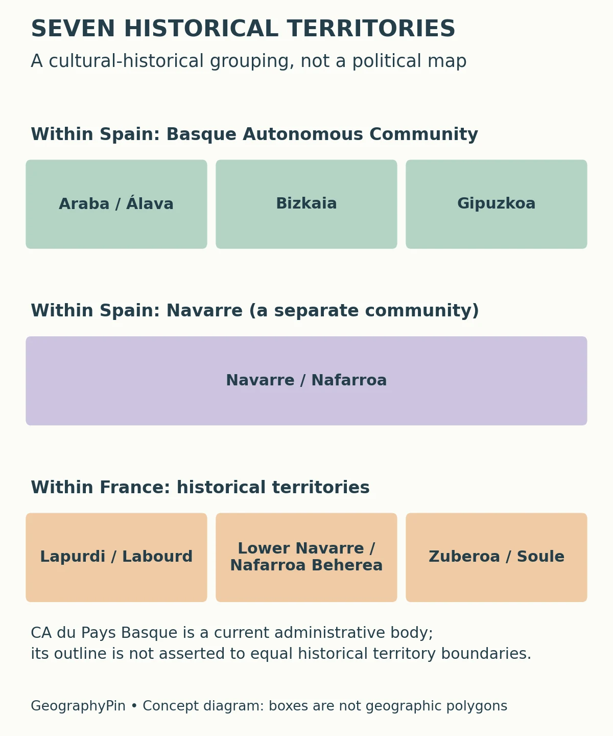
The term Euskal Herria is commonly used for the wider historical and cultural region. Euskadi is widely used in administrative contexts for the autonomous community, although institutional and historical writing can use terminology differently. It is safer to read the definition supplied by a source than to assume every occurrence of a name has exactly the same scope.
Language, culture and political status are related but distinct. A regional cultural tradition can extend across an international border without creating a single government. Equally, people living within the same administrative territory need not describe their identity in the same way.
The word “country” itself can be cultural or geographic as well as sovereign. Thus the direct political answer is that the Basque Country is not an independent sovereign state; the wider cultural use of the name remains meaningful without implying independence.
6. Coast, Mountains and Drainage Divides
One region does not mean one landscape
The coast faces the Bay of Biscay, while mountains and inland basins create sharp contrasts over comparatively short distances. In the autonomous community, the Basque Government distinguishes drainage toward the Cantabrian coast from rivers feeding the Ebro basin and ultimately the Mediterranean.
A mountain divide separates these drainage directions. Northern valleys descend toward the coast; farther inland, the Álava landscape connects with the Ebro system. A watershed is a physical boundary defined by drainage, not the same kind of line as a province or an international border.
Climate likewise varies within the region. Official Basque descriptions distinguish a humid oceanic northern side, transitional inland areas and a drier Mediterranean influence in southern Rioja Alavesa. A rainy coastal image should not be used as a complete description of the interior.
These contrasts help explain why a regional map benefits from both administrative labels and physical context. Towns, transport corridors and settlement patterns occupy particular valleys and coastal settings, while political units can extend across more than one physical environment. The same place can belong to an administrative region, a watershed and a cultural region at the same time. Our geography explainer develops this distinction between places, spatial relationships and the ways people interpret them.
7. Reading Names, Languages and Statistics Carefully
Ask which territory a number measures
Before comparing population, area or language figures, identify the territory, date and definition. A statistic for the three-territory autonomous community is not a total for the seven historical territories. A figure for the French intermunicipal body is not automatically a figure for the whole Pyrénées-Atlantiques department.
Bilingual and historical place names also need context. Araba and Álava refer to the same historical territory; Bizkaia and Biscay are different-language names associated with another. Donostia-San Sebastián names one city, not a pair of neighboring capitals. Use the labels on the map alongside the definition in its legend.
For language statements, distinguish legal status from the number of people who speak a language. Co-official status does not mean every resident is bilingual, and the presence of Basque place names alone does not measure everyday use. Such questions require suitable dated language surveys, not assumptions from a shaded map.
A useful final map check has three parts: identify the international boundary, identify the subnational or municipal units, and identify any historical or cultural overlay. Keeping those layers separate makes the Basque Country easier to understand without flattening its geography into one disputed label.
What Did We Learn Today?
Basque Country is a name with more than one territorial meaning. The autonomous community, Navarre, the French intermunicipal body and the wider historical framework describe different things. Political boundaries do not map personal identity, language status does not count speakers, and physical divides do not necessarily follow administrative lines.
Sources & Data Notes
Administrative descriptions are tied to the institutions named, while the seven-territory framework is identified as historical and cultural. The French commune count comes from the institution’s September 2026 account. No population, language-speaker count or area total combines these different definitions. Map boundaries do not identify the ethnicity or political preferences of residents.
- Basque Cultural Institute: Northern Basque Country / Iparralde. Names of the three historical territories on the French side; no population or area statistics imported.
- Government of Cantabria: regional environmental study. Physical geography introduction, page 36: Valle de Villaverde is a Cantabrian enclave within Bizkaia.
- Basque Government: Treviño study, 2023. Geographic introduction, page 11: the two-municipality enclave belongs to Burgos in Castile and León and is surrounded by Álava.
- Official Bizkaia tourism: Orduña. Orduña as a geographically detached part of Bizkaia, surrounded by Álava and Castilian territory.
- Government of Navarre: official capital names. Pamplona and Iruña identify the same city.
- Basque Statute of Autonomy. Institutional status, historical territories and official languages; the Navarre provision is conditional.
- BOE: 2023 consolidated law on the institutional seat. Vitoria-Gasteiz as seat of the Basque Parliament and Government.
- BOE: Navarre Organic Law 13/1982. Navarre’s institutional framework, capital and territorially specific language status.
- University of the Basque Country: political organization. The three historical territories and principal institutional centers.
- Communauté Pays Basque: institutional functions. September 2026 account of its creation and 158 member communes.
- General Assemblies of Bizkaia: Country of the Basques. Institutional explanation of the wider seven-territory historical and cultural framework.
- Basque Government: Ibaialde geography. Drainage divides and broad coastal–inland climatic contrasts.
The administrative map uses actual source polygons, retaining the Treviño and Valle de Villaverde exclusions and detached pieces of territory. The French intermunicipal contour comes from the official geographic API for entity 200067106, sourced from the administrative-contours dataset derived from IGN AdminExpress. Source data were retrieved on November 13, 2026; this is a geographic illustration, not a cadastral or legal boundary survey. Bayonne is shown by a representative municipal center; the Spanish city points and country context are generalized Natural Earth data. The international boundary is distinct from subnational lines. The historical-territory diagram is conceptual and does not invent cultural boundary coordinates. Original cartography: GeographyPin. Spanish boundaries and international border: © OpenStreetMap contributors, ODbL. French administrative outline and Bayonne center: data.gouv.fr / IGN, ODbL. Context and Spanish city points: Natural Earth, public domain.