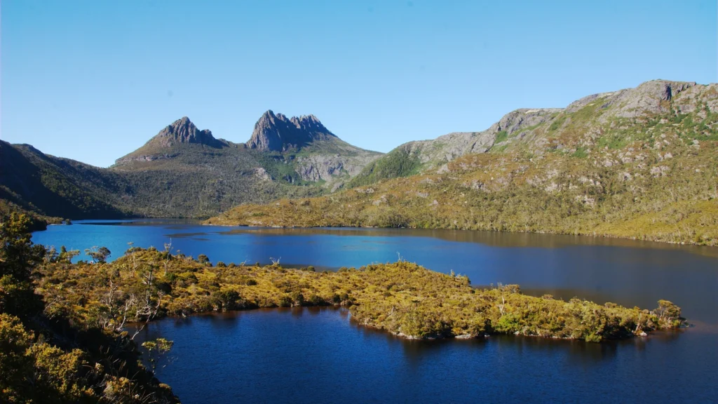
Cradle Mountain’s jagged skyline above Dove Lake is one view of a much larger Tasmanian landscape. The mountain becomes easier to understand when its rock, glacial surroundings and protected-area boundaries are considered separately.
Cradle Mountain is a dolerite peak in Tasmania, Australia, rising to about 5,069 feet (1,545 meters). It stands near the northern end of Cradle Mountain–Lake St Clair National Park, above Dove Lake. Its rock formed underground long before glaciers helped shape the surrounding valleys and lake landscape.
Read the landscape: Find the peak on the map, compare rock formation with glacial shaping, or check what the height measurement means.
1. Locate the peak, lake and national park
Cradle Mountain is in Tasmania, the island state south of mainland Australia. The peak stands near the northern end of Cradle Mountain–Lake St Clair National Park, with Dove Lake immediately to its north. The long park extends much farther south than the familiar mountain-and-lake view suggests.
Reading the mapped features
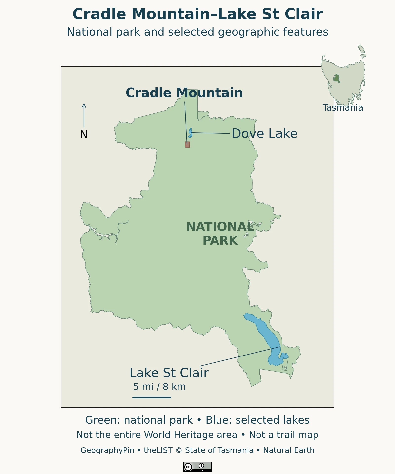
Read the map in that order: first find Tasmania, then the protected area, then the individual mountain. A label placed over a large park does not mean that every place inside it belongs to the mountain itself. The named mountain area is not an entrance or a recommended starting point.
The Tasmania Parks and Wildlife Service: Cradle Mountain identifies separate northern and southern access ends. There is no direct road through the park between Cradle Mountain and Lake St Clair. A journey connecting the two by road therefore cannot be planned simply by drawing a straight line along the park’s shape.
2. A dolerite mountain, not a volcanic cone
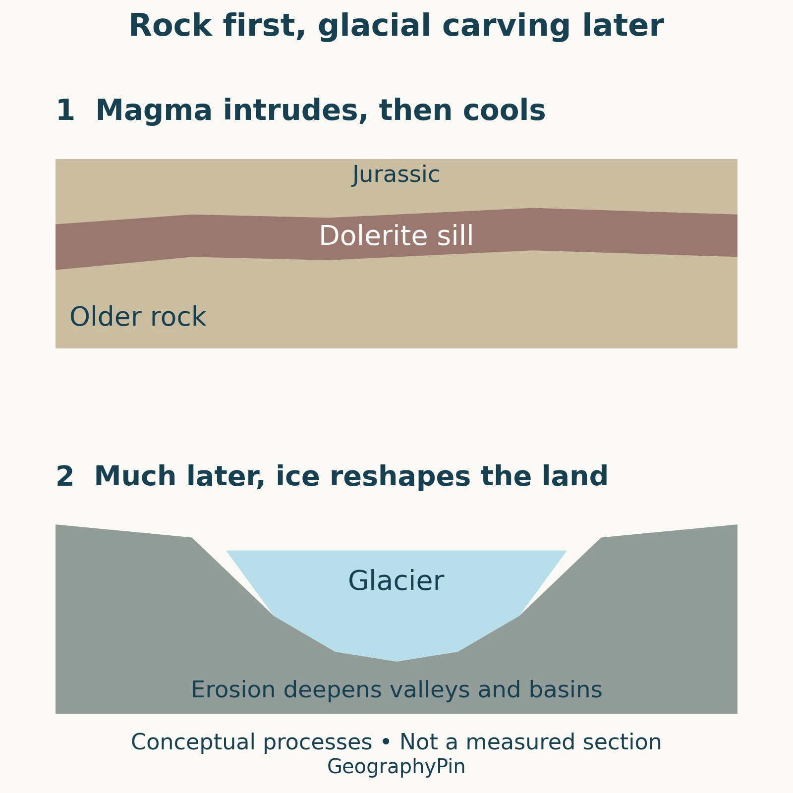
Cradle Mountain’s prominent rock is dolerite, an igneous rock that crystallized from magma underground. It should not be interpreted as a cone built by repeated surface eruptions. Dolerite and basalt have related compositions, but their cooling settings and resulting textures differ.
Lon Abbott, GSA Today (2026): Fire and Ice; DOI 10.1130/GSATG122GH.1 describes Jurassic intrusion and the columnar joints visible in the landscape. Cooling fractures help divide the rock into angular columns; the columns are not separate piles of lava placed side by side.
The mountain is also not made from an isolated block resting on an otherwise featureless foundation. The older I. B. Jennings: Geology of the Cradle Mountain Reserve (1958), Mineral Resources Tasmania describes relationships between dolerite, older sedimentary units and basement rocks. Those relationships change locally: the Wynyard sedimentary unit visible beneath Little Horn pinches out toward Cradle Mountain. A single layer cake drawn identically beneath every summit would conceal that variation.
Two different questions are involved here. “What is the mountain made of?” concerns the rock and its geological setting. “Why does the mountain have this shape?” concerns what later happened to that rock. This distinction is central to physical geography: identifying a material does not, by itself, explain the landscape visible today.
3. Much later, ice reshaped the landscape
The rock is older than the glacial scenery. Moving ice eroded and redistributed material around the mountain long after the dolerite formed. The result is a landscape in which rock structure and glacial action both matter, rather than one in which a glacier somehow created the igneous rock.
Dove Lake in the glacial story
The 2026 GSA account describes ice occupying the northern side of the mountain and reaching the Dove Lake area during the last glaciation. Its reconstruction explains why the lake belongs in the geological story, not only in a scenic photograph. It does not imply that today’s lake is a surviving glacier.
4. Dove Lake and the living landscape
The Parks and Wildlife Service: Dove Lake describes a lake shaped by glaciation beneath Cradle Mountain. Around it, the visitor encounters changing vegetation, including buttongrass and rainforest. The lake is therefore useful for reading both the physical setting and the ecological contrasts around the peak.
A recognizable seasonal feature is fagus, the deciduous beech Nothofagus gunnii. According to the Parks and Wildlife Service: fagus, this Tasmanian endemic occurs in long-unburnt areas and loses its leaves in winter. Autumn color is a seasonal response, not a fixed annual appointment that can be guaranteed for a particular date.
A photograph captures only one combination of season, weather and viewpoint. Green vegetation in one image and autumn color in another need not mean that either image depicts the wrong mountain. For interpreting the landform, compare the rock skyline and lake relationship; for interpreting vegetation, also consider when the photograph was taken.
5. Summit height is not the height of your climb
The Parks and Wildlife Service: Overland Track walk notes gives Cradle Mountain’s summit elevation as approximately 5,069 feet (1,545 meters). Elevation measures height above sea level. It is not the amount every walker must climb, because a route begins above sea level and may include additional descents and ascents.
Compare the measurements
| Measurement | What it tells you |
|---|---|
| 5,069 feet (1,545 m) | Published summit elevation above sea level. |
| Route ascent | Uphill height accumulated along a particular route, not the summit elevation. |
| Walking distance | Length along a route, not vertical height or straight-line map distance. |
This matters when comparing a lakeside circuit with the summit walk. Official descriptions classify the Dove Lake circuit as Grade 3 and Cradle Summit as Grade 5. The Parks and Wildlife Service: Cradle Summit describes exposed scrambling and warns against attempting the summit in unsuitable weather. A familiar photograph of the peak is not evidence that the route to its top is straightforward.
Use current park guidance for access, closures and weather-dependent decisions. A geographic profile explains the setting; it cannot establish that a particular path is open or suitable on the day of a visit.
6. The national park is part of a larger World Heritage area
Cradle Mountain–Lake St Clair National Park and the Tasmanian Wilderness World Heritage Area are not interchangeable boundaries. The park is one protected area within a broader recognized landscape. A map of one should not be relabeled as the other.
UNESCO: Tasmanian Wilderness recognizes the Tasmanian Wilderness for both natural and cultural values. Its inscription began in 1982. The cultural significance includes evidence of Aboriginal occupation, so describing the region as an entirely empty landscape untouched by people would be misleading.
These distinctions also change how a statistic should be read. A total area quoted for the World Heritage property does not give the area of this national park, and neither figure gives the area of Cradle Mountain. Before comparing numbers, identify whether the subject is a peak, a protected area or the larger World Heritage property.
Frequently Asked Questions
Can you see Cradle Mountain without climbing to its summit?
Yes. Dove Lake lies below the peak and offers views of the mountain when conditions allow. Seeing the mountain from the lake and completing the exposed summit route are different experiences; neither visibility nor access is guaranteed in all weather.
Does snow in a photograph mean there is a glacier there today?
No. Seasonal snow and a glacier are different things. The glacial explanation here concerns past landscape shaping; a photograph showing snow does not establish the presence of a present-day glacier.
What Did We Learn Today?
Cradle Mountain combines underground rock formation with much later glacial landscape change. Reading it accurately means separating summit elevation from climbing effort, the peak from its national park, and that park from the wider World Heritage area. Dove Lake connects the familiar view to the landscape’s physical history.
Sources & Data Notes
Summit elevation follows the Parks and Wildlife Service walk notes. The conversion uses 1 meter = approximately 3.28084 feet and rounds to the nearest foot. The geology discussion distinguishes Jurassic rock formation from much later glaciation. The older geological report supports local rock relationships, not current visitor information. The original process drawing is conceptual and does not copy published geological figures.
- Tasmania Parks and Wildlife Service: Cradle Mountain
- Lon Abbott, GSA Today (2026): Fire and Ice; DOI 10.1130/GSATG122GH.1
- I. B. Jennings: Geology of the Cradle Mountain Reserve (1958), Mineral Resources Tasmania
- Parks and Wildlife Service: Overland Track walk notes
- Parks and Wildlife Service: Dove Lake
- Parks and Wildlife Service: fagus
- UNESCO: Tasmanian Wilderness
- Parks and Wildlife Service: Cradle Summit
Map and photograph credits: Map adapted by GeographyPin from LIST Public Land Classification, Named Features and Water Bodies from theLIST © State of Tasmania, CC BY 3.0 Australia. The green national-park outline uses six official land-classification polygons; the mountain uses a named-area polygon, not a surveyed summit coordinate. Selected lakes use official water-body outlines. The Tasmania inset uses Natural Earth data (public domain) at a separate scale. The main map uses an equirectangular view centered at 42°S. It shows neither the full World Heritage boundary nor walking routes.
The featured photograph shows Dove Lake and Cradle Mountain from Glacier Rock on January 13, 2009. Photo: Karora, Wikimedia Commons, released into the public domain by the photographer; cropped and resized. It does not show current conditions. The rock-and-ice diagram is original GeographyPin artwork explaining general processes, not a reproduction of the published GSA illustrations.