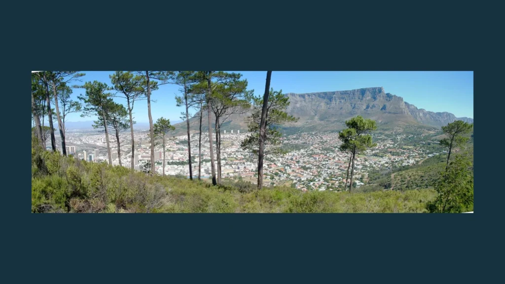
Table Mountain’s skyline looks simple: a broad, nearly level top above Cape Town. Look more closely, and the mountain becomes a story of resistant sandstone, older basement rocks, changing weather, and a peninsula that extends well beyond the city’s best-known view.
Table Mountain stands beside Cape Town on South Africa’s Cape Peninsula. Its highest point is Maclear’s Beacon, approximately 3,563 feet (1,086 meters) above sea level. Resistant sandstone helps form its prominent cliffs and flat-looking skyline. The mountain is part of a wider national park and the Cape Floral Region’s protected landscapes.
How to use this article: Distinguish the mountain from the park, check the summit measurements, or explore the rocks behind the skyline.
1. Where is Table Mountain?
Table Mountain rises beside Cape Town in South Africa’s Western Cape. It stands in the northern part of the Cape Peninsula, where a chain of mountains continues south toward Cape Point. The familiar flat skyline is one part of that larger landscape, not the whole peninsula.
The Atlantic coast lies to the west. Farther southeast, False Bay and the low-lying Cape Flats help separate the peninsula’s mountain chain from the mainland’s mountainous interior. This setting makes a locator map more useful than an isolated photograph: the mountain belongs to both an urban landscape and a much larger coastal peninsula.
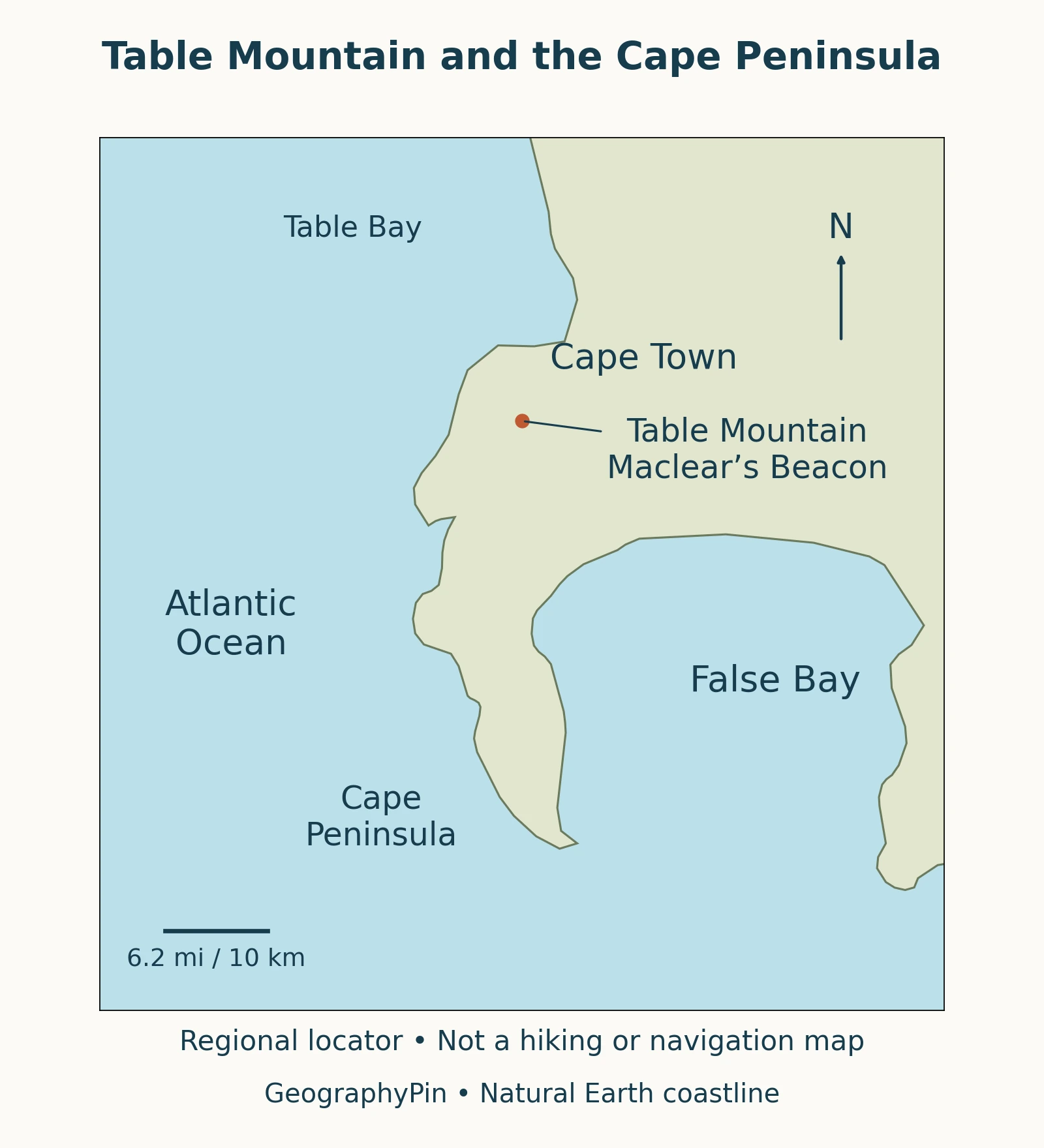
The mountain and the national park are not the same thing
Table Mountain is a landform. Table Mountain National Park is a protected area containing several parts of the peninsula, including places far from the summit. A reference to the park should not be read as a description of the mountain’s plateau alone. The SANParks: 2015–2025 Park Management Plan describes this wider geographical setting.
2. How high is Table Mountain?
Maclear’s Beacon marks the highest part of Table Mountain. A useful approximate elevation is 3,563 feet (1,086 meters) above sea level. That meter figure is reported for the primary survey station in Sterken (2026): Geodetic Surveying in South Africa, drawing on earlier surveying history rather than announcing a new measurement.
Why published heights differ slightly
Authoritative references do not all give the same number. The SANParks 2015–2025 management plan lists 3,570 feet (1,088 meters), while the Cableway’s older visitor guide gives 3,560 feet (1,085 meters). These small differences should not be turned into claims that the mountain has grown or shrunk.
The sources do not establish a common explanation for the discrepancy. For that reason, the approximate summit value here is tied to its reference, not presented as a newly verified survey. Nor should the height of a cable station or viewing terrace be substituted for the mountain’s high point.
“Flat-topped” describes the appearance of the skyline. It does not mean every spot on top has the same elevation or that the plateau is a level paved surface. A summit landscape can look nearly horizontal from the city while still containing uneven ground, local rises, and steep edges.
3. The sandstone layers behind the skyline
The bulk of Table Mountain’s upper cliffs consists of the Peninsula Formation, a resistant sandstone. Beneath it lies the Graafwater Formation, which includes sandstone and finer-grained sedimentary beds. Older rocks, including Cape granite, form the underlying foundation in parts of the peninsula.
These names describe geological units, not three independent mountains. SANParks: Table Mountain Geology identifies the main formations, including the Pakhuis Formation preserved near the highest ground.
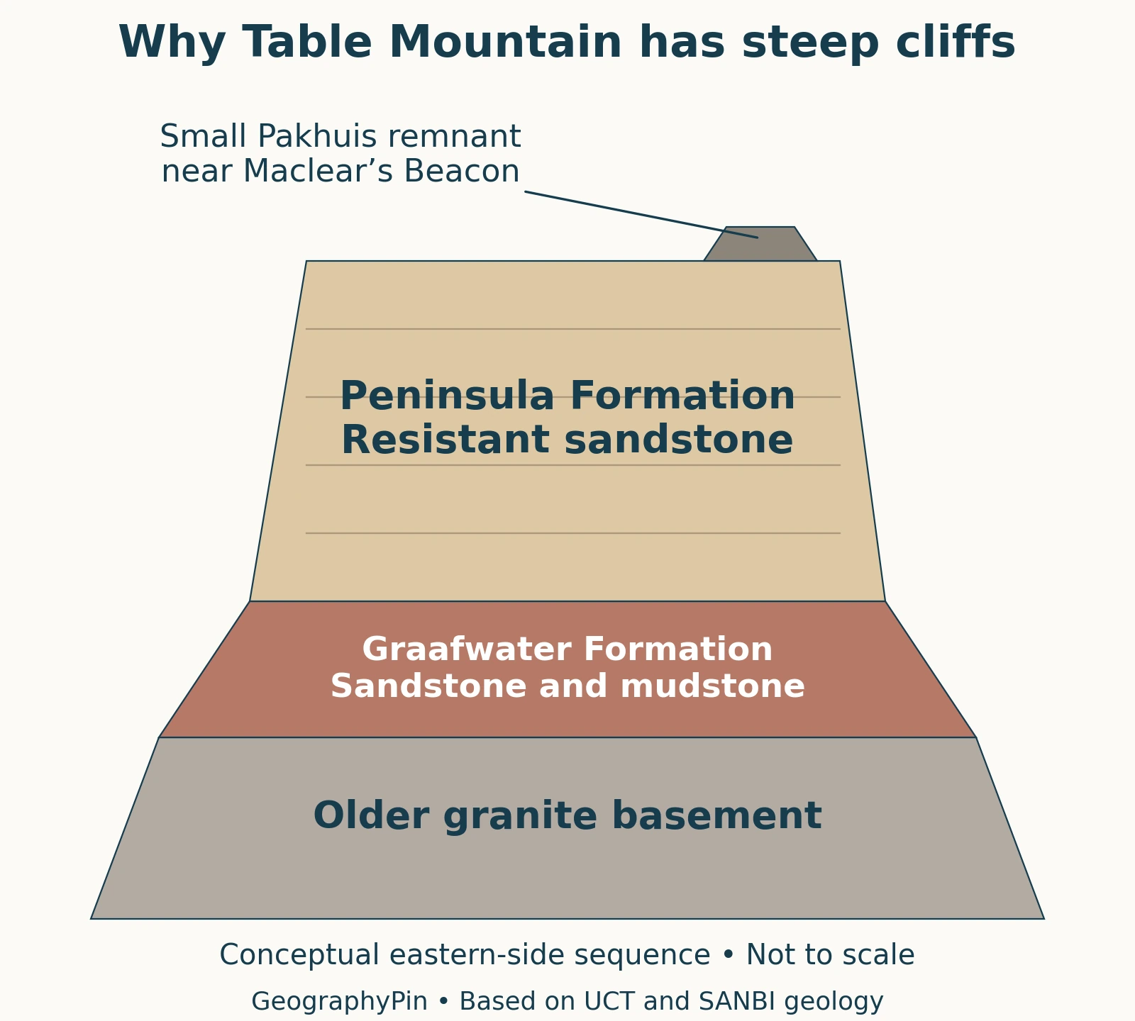
Sandstone and granite record different processes
Sandstone began as sediment deposited and later compacted and cemented into rock. Granite formed when magma cooled and crystallized below the surface. The granite’s presence does not make Table Mountain a volcanic cone.
On the Kirstenbosch side, the visible sequence includes Peninsula sandstone over Graafwater beds and granite basement. SANBI: Kirstenbosch Geology describes these rocks and their contrasting behavior during weathering. The diagram is a simplified explanation of their relationship, not a survey showing the thickness of each layer beneath every point.
A small surviving Pakhuis deposit near Maclear’s Beacon preserves evidence of ancient glacial sediment. It should not be drawn as a continuous cap over the entire summit. University of Cape Town: Geology of Cape Town describes its localized occurrence.
4. Why is Table Mountain flat-topped?
The short answer involves rock structure and differential erosion. Resistant sandstone survives as prominent cliffs and high ground, while other material is more readily removed. The present mountain is an erosional remnant, not a freshly built platform.
UCT’s geological account suggests that Table Mountain may preserve a downfaulted trough of a larger fold, left standing as surrounding rocks were eroded. That is a geological interpretation, not a reason to draw the whole mountain as a perfectly undisturbed stack.
A durable cliff can still break down
Hard sandstone is resistant, not indestructible. SANBI describes softer underlying beds being worn away, leaving overhangs that can eventually collapse under gravity. Fallen blocks on lower slopes are part of that continuing erosion.
This also explains why the age of the rock is not the age of the visible mountain shape. Sediment deposition, burial, deformation, uplift, and erosion are different stages. Calling Table Mountain “hundreds of millions of years old” without saying what is being dated can hide more than it explains.
The distinction is a useful example of physical geography: the landscape we see combines geological materials with processes that continue to alter them.
5. The tablecloth, climate and living landscape
The Cape Peninsula has a Mediterranean-type climate: generally warmer, drier summers and cooler, wetter winters. Winter weather systems bring rain, while summer southeasterly winds can carry moisture against the mountain barrier. SANParks: Cape Peninsula Climate describes how relief and exposure create differences across the peninsula.
The famous “tablecloth” is cloud associated with the mountain and the southeaster. It can obscure the plateau even when parts of the city remain visible below. A clear view from one neighborhood does not establish conditions on every slope or on top.
Fynbos connects the mountain to the Cape Floral Region
Fynbos is a distinctive shrubland, including plants such as proteas, ericas, and restios. Its relationship with nutrient-poor soils, seasonal rainfall, and periodic fire helps explain why the mountain is much more than a bare rock landmark. SANParks: Natural and Cultural History discusses that ecological setting.
Table Mountain National Park forms part of the Cape Floral Region Protected Areas World Heritage property. The wider property comprises multiple protected-area clusters, rather than one uninterrupted reserve centered on the summit. UNESCO: Cape Floral Region Protected Areas emphasizes its plant diversity and evolutionary and ecological processes.
Statistics for the entire Cape Floral Region should not be relabeled as the number of species living on Table Mountain. The mountain, park, peninsula, and floristic region describe different geographical areas.
6. Reading the landscape before a visit
Geography explains the setting; it does not confirm that a route or cableway is open. For operating status, hours, and ticket information, use the Table Mountain Aerial Cableway. Those details can change and are separate from the mountain’s relatively stable physical description.
The Cableway provides access to the upper mountain, but a cableway visit and a walk to Maclear’s Beacon are not interchangeable destinations. Check a suitable visitor map rather than assuming every summit landmark is next to the station.
SANParks: Visiting Table Mountain warns that the mountain remains a wild setting despite its position beside a major city. It has sheer cliffs, challenging routes, and cold conditions. Stay on established paths, use appropriate equipment, and check official advice before setting out.
The locator in this article is for geographical orientation, not trail navigation. Its place markers do not identify safe routes, current closures, climbing lines, or emergency access. Those require current, purpose-made information.
What Did We Learn Today?
Table Mountain is both a distinctive landform and part of a much larger coastal landscape. Its sandstone cliffs, older underlying rocks, and ongoing erosion explain more than the skyline alone. Maclear’s Beacon identifies its highest ground, while the national park and Cape Floral Region extend the story beyond one summit. Keeping those geographical scales separate makes maps, heights, and conservation descriptions easier to understand.
Sources & Data Notes
The summit figure is attributed, not a new survey. Published heights differ slightly; the cited park management plan covers 2015–2025. The geological diagram is conceptual and does not assign measured thicknesses to its layers. The locator uses Natural Earth public-domain coastline data, with approximate regional placement checked against SANParks mapping. The featured photograph is “Table Mountain” by Conrad Freethy (February 2001), via Wikimedia Commons, CC BY 2.5; resized, placed on a neutral background and converted to WebP. It is a historical view, not a current-condition image.
- University of Cape Town: Geology of Cape Town
- SANParks: Table Mountain Geology
- SANBI: Kirstenbosch Geology
- Sterken (2026): Geodetic Surveying in South Africa
- SANParks: 2015–2025 Park Management Plan
- SANParks: Cape Peninsula Climate
- SANParks: Natural and Cultural History
- UNESCO: Cape Floral Region Protected Areas
- SANParks: Visiting Table Mountain
- Table Mountain Aerial Cableway
- Cableway 2016 visitor guide: historical elevation comparison only, not current visitor information.