Grandfather Mountain is known for both rugged ridges and rhododendron flowers, but those two views tell only part of its story. Its highest summit, private attraction, state park, and changing plant communities need to be distinguished before a map or bloom calendar becomes useful.
Grandfather Mountain rises in western North Carolina’s Blue Ridge. Its highest point, Calloway Peak, reaches 5,946 feet (1,812 meters). Forests and exposed summits support varied habitats, including rhododendrons with different flowering seasons. The state park and the private attraction containing the Mile High Swinging Bridge are separate places to plan for.
How to use this article: Distinguish the bridge from the summit, compare flowering seasons, or check the two visitor arrangements.
1. Where is Grandfather Mountain?
Grandfather Mountain rises in the Blue Ridge of western North Carolina. North Carolina State Parks places its parkland in Avery, Caldwell, and Watauga counties, about 13 miles (21 kilometers) southwest of Boone. The mountain is part of the southern Appalachian landscape, not an isolated volcanic peak. The Appalachian Mountains map places the Blue Ridge within the wider mountain system.
A useful map must separate the physical mountain from the places managed around it. The state park, the privately operated attraction, and nearby Blue Ridge Parkway lands are not one visitor facility. A point labeled “Grandfather Mountain” cannot identify every entrance, trailhead, or summit.
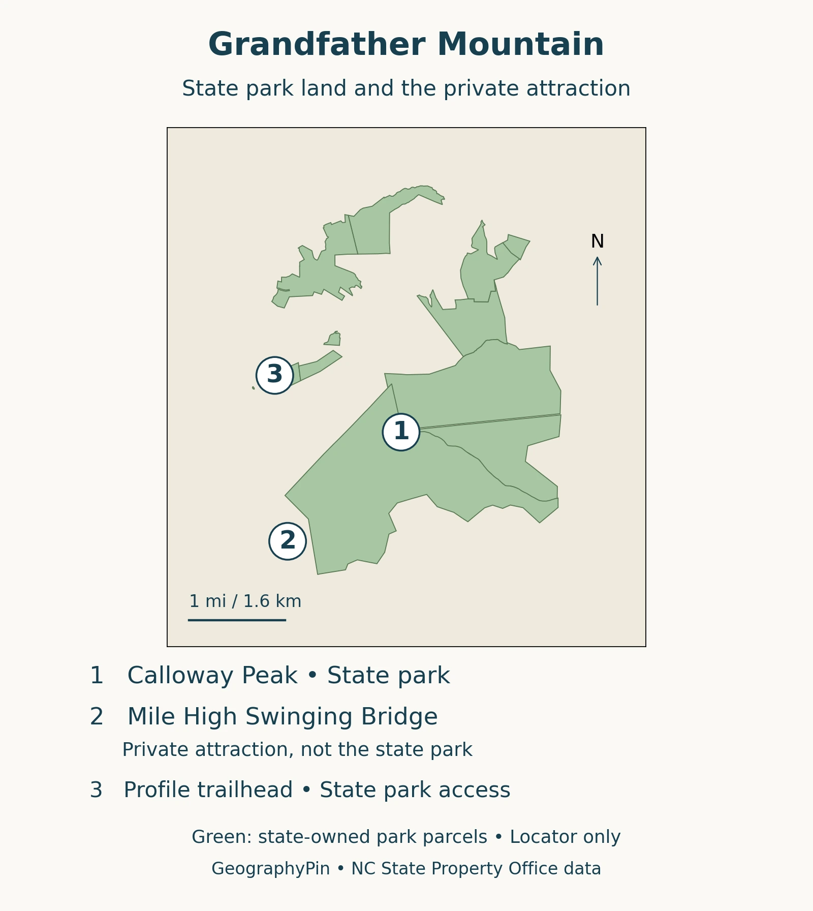
The state park’s official trail map provides the more detailed trail context. The geographical map here is not a substitute for current closure notices, route descriptions, or navigation on exposed terrain.
2. Which elevation belongs to the summit?
Calloway Peak is Grandfather Mountain’s highest point, at 5,946 feet (approximately 1,812 meters) above sea level. Both North Carolina State Parks and the U.S. Fish and Wildlife Service report that height. It describes the summit, not the elevation of a visitor center, entrance gate, or bridge.
The official park map also labels MacRae Peak at 5,845 feet (approximately 1,782 meters). These are separate high points on the mountain, which has a ridge-and-peak landscape rather than one smooth summit dome.
The Mile High Swinging Bridge is not the highest point
The Mile High Swinging Bridge is a separate visitor destination. It belongs to the private attraction, while Calloway Peak is the mountain’s high point. Visiting the bridge and reaching Calloway Peak are different destinations; a description of one should not be used as a route or accessibility description of the other.
The state park warns that the mountain can be colder than the Banner Elk forecast. A nearby town’s forecast is therefore not a precise prediction for the ridge.
3. When do the rhododendrons flower?
There is no single bloom date for every rhododendron on Grandfather Mountain. Species, elevation, and weather all matter. A purple-flowered shrub photographed beside a road in one week does not prove that the same stage has reached every higher slope.
Catawba and rosebay do not share one timetable
| Species | Flower color | Timing guide |
|---|---|---|
| Catawba rhododendron Rhododendron catawbiense | Pink to purple | Late spring into early summer; local accounts emphasize May and June. |
| Rosebay rhododendron Rhododendron maximum | White to pale pink | Generally later; Grandfather’s description highlights late June. |
The Foundation’s Grandfather Mountain: Wildflower Bloom Calendar places Catawba under May and rosebay under June. Its more detailed Grandfather Mountain: Rhododendron Rambles describes Catawba flowering in early to mid-June depending on elevation. These are overlapping seasonal guides, not competing promises of an exact peak day.
Across the Blue Ridge Parkway, the National Park Service: Blue Ridge Parkway blooms explains that cooler conditions at higher elevations can delay flowering by several weeks. North-south position also matters. That regional pattern helps explain why photographs from another mountain, or even a lower part of the same mountain, may show a different stage.
For a flowering visit, check the mountain’s recent bloom reports rather than relying only on a month printed in an evergreen guide. A past festival date is not evidence that flowers will peak on that date next year.
4. A small mountain area with many habitats
The vegetation changes with height, but it does not form a stack of perfectly horizontal bands. Soil, moisture, slope position, and exposure affect where communities occur. These connections between landforms, climate and vegetation are part of physical geography. The Foundation’s Grandfather Mountain: Natural Communities describes overlapping communities, including cove forests, northern hardwood forests, spruce-fir forests, heath balds, and rocky summits.
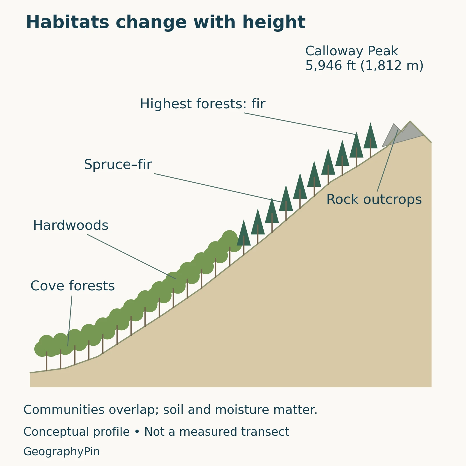
Cove forests occupy lower or middle mountain settings, while northern hardwood communities include trees such as birch, beech, and maple. Higher ground supports red spruce and Fraser fir, with Fraser fir favoring the highest forested terrain. A rocky summit or shrub-covered heath bald is not the same habitat as an adjacent forest.
The U.S. Fish and Wildlife Service: Southern Appalachian spruce restoration describes Grandfather as one of the Southern Appalachians’ mountain “sky islands.” The term refers to cool, moist high-ground habitats separated by warmer lower terrain, not to islands surrounded by water.
This pattern matters for conservation. Spruce-fir forests support specialized wildlife, including the spruce-fir moss spider and Carolina northern flying squirrel. Regional restoration efforts address the legacy of logging and fire as well as damage associated with the balsam woolly adelgid, an insect that attacks fir trees.
The elevation profile illustrates broad relationships, not surveyed vegetation boundaries. A real slope can contain several communities at similar heights, and the map of a park does not double as a habitat map.
5. What the rocks reveal
Grandfather Mountain’s rocks have experienced deformation and metamorphism: changes produced by pressure, heat, and related processes. The local geology descriptions identify metamorphosed conglomerate around Split Rock and finer-grained metamorphic rocks near the upper parking area. A conglomerate begins as rock fragments bound together; metamorphism alters that original material.
The mountain also gives its name to a much larger geological feature, the Grandfather Mountain window. In a geological window, erosion exposes rocks beneath an overlying thrust sheet. It is not a cave or a literal opening through a summit.
The USGS: Grandfather Mountain Window geology data release describes the Blue Ridge thrust sheet as breached by erosion in this region. The exposed rocks include older basement rocks and sedimentary and volcanic sequences. The relationship is more complicated than saying every visible rock is one age or every lower layer must be younger.
Rock age, the time of mountain building, and the age of today’s eroded landforms answer different questions. Ancient rock can be part of a landscape that has changed repeatedly. A single “age of the mountain” is therefore less informative than distinguishing the materials, deformation, and erosion.
6. State park and private attraction: choose the right information
One mountain, separate visitor arrangements
North Carolina State Parks: Grandfather Mountain explicitly distinguishes the state park from the privately owned attraction containing the Mile High Swinging Bridge. The state park’s day-use access has no entrance fee; the attraction charges admission. Camping and other arrangements are separate, and current details belong on the relevant operator’s website.
The Grandfather Mountain Stewardship Foundation publishes its own opening information, tickets, and weather-related updates. State park notices cover its trails and accesses. Neither website’s operating information should be treated as automatically applying to every part of the mountain.
Some state park trails involve steep, exposed terrain, ladders, or cables. A seasonal flower photograph does not describe the difficulty of reaching that location. Consult the official trail information and current advisories before choosing a route, and do not infer that a trail is open merely because it appears on a map.
Frequently Asked Questions
Are the azaleas on Grandfather Mountain rhododendrons too?
Yes. The pink-shell azalea, Rhododendron vaseyi, and flame azalea, Rhododendron calendulaceum, belong to the same genus as Catawba and rosebay rhododendrons. Their common names and flower colors differ, so a report that “rhododendrons are blooming” may need a more specific identification.
What Did We Learn Today?
Grandfather Mountain combines a varied ridge landscape, altered rocks, and plant communities shaped by elevation and local conditions. Its rhododendrons do not flower on one universal schedule, and its visitor destinations do not share one management system. Keeping summit heights, habitat patterns, flowering guides, and access information separate makes the mountain easier to understand.
Sources & Data Notes
Summit elevations follow North Carolina State Parks, with metric equivalents rounded to the nearest meter. Bloom periods are seasonal guidance, not a live flowering forecast. Geological discussion distinguishes the mountain from the broader structural window; the USGS data release preserves regional geological descriptions rather than dating the present skyline. Habitat boundaries are conceptual, not surveyed lines.
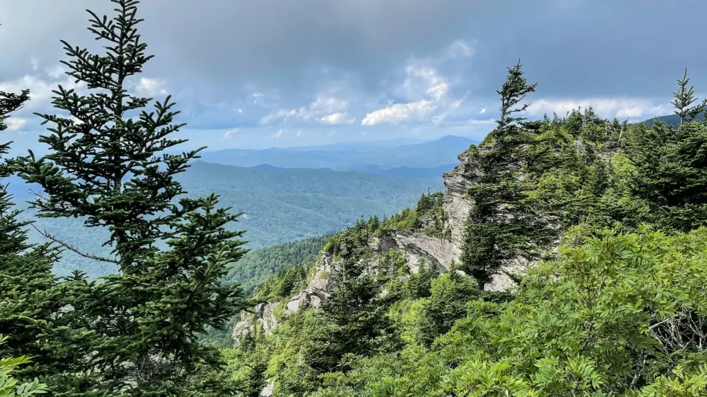
The context map uses 11 parcels from the North Carolina State Property Office inventory; it does not draw a private-property boundary. Its equirectangular display uses 36.11°N, with an approximate local scale. Peak and bridge locators are approximate rather than survey positions; the official park map was used to check their relationships. The featured image is a view from Grandfather Mountain by Sue Cameron/USFWS, August 2022, explicitly public domain; cropped, resized and converted to WebP. It is not a live condition report.
- Grandfather Mountain: Mile High Swinging Bridge
- North Carolina State Parks: Grandfather Mountain
- North Carolina State Parks: Grandfather Mountain map
- Grandfather Mountain: Wildflower Bloom Calendar
- Grandfather Mountain: Rhododendron Rambles
- National Park Service: Blue Ridge Parkway blooms
- Grandfather Mountain: Natural Communities
- U.S. Fish and Wildlife Service: Southern Appalachian spruce restoration
- USGS: Grandfather Mountain Window geology data release
- Grandfather Mountain: Local rock descriptions
- Grandfather Mountain Stewardship Foundation